
Macksville is a small town on the Nambucca River in the Nambucca Valley, New South Wales, Australia. It is halfway between Sydney and Brisbane, along the Pacific Highway, approximately 40 minutes north of Kempsey, 40 minutes south of Coffs Harbour, 1 hour 10 minutes north of Port Macquarie, 5 hours south of Brisbane and 5 hours north of Sydney.

Kirby is an unincorporated community in Hampshire County in the U.S. state of West Virginia situated along Grassy Lick Run, a tributary of North River. Kirby is located south of Romney at the crossroads of Grassy Lick Road and Rock Oak Road.

Pleasant Dale is an unincorporated community in Hampshire County in the U.S. state of West Virginia. Pleasant Dale is located between Capon Bridge and Augusta on the Northwestern Turnpike. Tearcoat Creek flows through Pleasant Dale and offers whitewater rafting in the Spring from the U.S. Route 50 bridge to its confluence with the North River.
Purgitsville is an unincorporated community in Hampshire County in the U.S. state of West Virginia. According to the 2000 census, the ZCTA for Purgitsville had a population of 813. Purgitsville is located on U.S. Highway 220/West Virginia Route 28 at its intersection with Huffman Road south of Junction. An elementary school, Mill Creek Elementary, was open here until 1993 when it was consolidated with Romney Elementary.

Shanks is an unincorporated community in Hampshire County in the U.S. state of West Virginia. According to the 2000 census, the Shanks community has a population of 806.

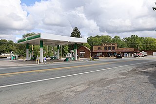
Wappocomo is an unincorporated community in Hampshire County in the U.S. state of West Virginia. The community is located south of Springfield on West Virginia Route 28 at Hanging Rocks along the South Branch Potomac River. Wappocomo has also historically been referred to as The Rocks, Wapocoma, and Wapocomo.
Loom is an unincorporated community in Hampshire County, West Virginia, United States. Loom is located between Capon Bridge and Hanging Rock along the Northwestern Turnpike on the western flanks of Cooper Mountain. Timber Mountain Road and Beck's Gap Road converge at Loom on U.S. Route 50.
Rada is an unincorporated community in Hampshire County in the U.S. state of West Virginia. Rada is located on U.S. Highway 220/West Virginia Route 28 between Junction and Purgitsville in southwest Hampshire County along Mill Creek. It lies at an intersection of US 220/WV 28 with Rada Road.
Baker is an unincorporated community on the Lost River in Hardy County, West Virginia, United States. Baker is located at the intersection of U.S. Route 48, West Virginia Route 55, West Virginia Route 29 and West Virginia Route 259. The ZCTA population for Baker's ZIP Code was 1,262 at the 2000 census, though the zip code covers a much larger area than the actual community itself.
The Huntington–Ashland metropolitan area is a metropolitan area in the Appalachian Plateau region of the United States. Referred to locally as the “Tri-State area”, the region spans seven counties in the three states of West Virginia, Kentucky, and Ohio. With a population of 361,580, the Tri-State area is nestled along the banks of the Ohio River. The region offers a diverse range of outdoor activities.
Bream is an unincorporated community along Indian Creek Rd in Kanawha County, West Virginia, United States. It is the first community after State Route 114 turns across the Elk River to Big Chimney. Bream is located between Milliken and Pinch, and is usually omitted from the map, because of its size.
Belva is an unincorporated community and census-designated place in west Nicholas County and north Fayette County, West Virginia, United States; while the CDP only includes the Nicholas County portion, the Fayette County portion is considered part of the community. The town is situated at the bottomland surrounding the convergence of Bells Creek with Twentymile Creek and, subsequently, Twenty Mile Creek with the Gauley River. Belva is also the location of the convergence of two state highways: West Virginia Route 16 and West Virginia Route 39.
Verdunville is an unincorporated community and census-designated place (CDP) in Logan County, West Virginia, United States. It is 3.5 miles (5.6 km) west of Logan, the county seat. Verdunville has a post office with ZIP code 25649. The Verdunville CDP includes the neighboring community of Shegon. As of the 2010 census, the total CDP population was 687.
Davin is an unincorporated community in Logan County, West Virginia, United States. Davin is located on West Virginia Route 10 and Huff Creek, 3 miles (4.8 km) east-southeast of Man. Davin has a post office with ZIP code 25617. Davin's population is counted as part of the Mallory census-designated place.
Edray is an unincorporated community in Pocahontas County, West Virginia, United States. Edray is located near U.S. Route 219 and West Virginia Route 55, 3.5 miles (5.6 km) north of Marlinton. It is home to the Edray State Trout Hatchery.
Mace is an unincorporated community in Pocahontas County, West Virginia, United States. Mace is located on U.S. Route 219 and West Virginia Route 55, 16.5 miles (26.6 km) north-northeast of Marlinton.
Dickinson, also known as Quincy, is an unincorporated community in Kanawha County, West Virginia, United States. Dickinson is located on the north bank of the Kanawha River, 3 miles (4.8 km) southeast of Belle. The community is served by U.S. Route 60.
Silverton is an unincorporated community in Jackson County, West Virginia, United States. Silverton is located at the junction of Interstate 77, U.S. Route 33 and West Virginia Route 2, 3 miles (4.8 km) southeast of Ravenswood.
Fellowsville is an unincorporated community in Preston County, West Virginia, United States. Fellowsville is located at the junction of U.S. Route 50 and West Virginia Route 26, 4.5 miles (7.2 km) south-southeast of Newburg.
Deerwalk is an unincorporated community in Wood County, West Virginia, United States. Deerwalk is located on West Virginia Route 31 north of its junction with U.S. Route 50, 12.5 miles (20.1 km) east of Parkersburg.


