
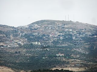
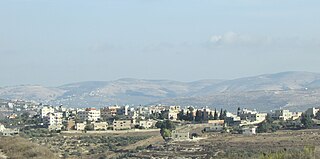
Tell, pronounced Till, is a Palestinian town in the Nablus Governorate in northern West Bank, located five kilometers southwest of Nablus. According to the Palestinian Central Bureau of Statistics (PCBS), the town had a population of 4,334 inhabitants in 2007. Most of the town's laborers work in agriculture, with figs and olives being the major source of income.

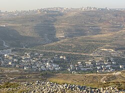
Asira ash-Shamaliya is a Palestinian town in the Nablus Governorate, located 3.5 kilometers north of Nablus in the northern West Bank. According to the Palestinian Central Bureau of Statistics, the town had a population of approximately 8,813 inhabitants in 2017.

Jinsafut is a Palestinian village in the Qalqilya Governorate in the northeastern West Bank, located east of Qalqilya. According to the Palestinian Central Bureau of Statistics, the village had a population of approximately 2,300 inhabitants in mid-year 2006.

Duma is Palestinian town in the Nablus Governorate in the northern West Bank, located 25 kilometers southeast of Nablus. According to the Palestinian Central Bureau of Statistics, the town had a population of 2,220 inhabitants in mid-year 2006. Duma's total land area consists of 17,351 dunams, about 200 of which are designated as built-up area.
Bizzariya is a Palestinian village in the northern West Bank, located 13.3 kilometers northwest of Nablus at the northernmost point of the Nablus Governorate. It is situated in a valley, having an altitude of 460 meters above sea level. According to the Palestinian Central Bureau of Statistics, Bizzariya had a population of over 2,252 inhabitants in 2007.

Jit is a Palestinian town in the northern West Bank, located 10 kilometers (6.2 mi) west of Nablus. According to the Palestinian Central Bureau of Statistics, the village had a population of approximately 2,320 inhabitants in 2006.
Einabus is a Palestinian village in the northern West Bank, located 12 kilometers south of Nablus and a part of the Nablus Governorate. Nearby towns include Huwara and Beita to the east and Jammain to the south.

Qabalan is a Palestinian town in the Nablus Governorate in the eastern West Bank, located 19 kilometers (12 mi) southeast of Nablus. According to the Palestinian Central Bureau of Statistics (PCBS), the town had a population of 7,130 inhabitants in 2007.

’Asira al-Qibliya is a Palestinian village in the Nablus Governorate in the eastern West Bank, located southwest of Nablus. According to the Palestinian Central Bureau of Statistics (PCBS), the village had a population of 2,935 inhabitants in 2017.
’Azmut is a Palestinian village in the Nablus Governorate in the eastern West Bank, located five kilometers northeast of Nablus. According to the Palestinian Central Bureau of Statistics (PCBS), the village had a population of 2,724 inhabitants in mid-2006.
Kafr Laqif is a Palestinian village in the Qalqilya Governorate in the western West Bank, located 22 kilometers southwest of Nablus. According to the Palestinian Central Bureau of Statistics, the village had a population of approximately 984 inhabitants in 2006.

Burin is a Palestinian village in the Nablus Governorate of the State of Palestine, in the northern West Bank, located 7 kilometres (4.3 mi) southwest of Nablus. The town had a population of around 2,800 in 2008.
Deir Sharaf is a Palestinian town in the Nablus Governorate in northern West Bank, located northwest of Nablus. According to the Palestinian Central Bureau of Statistics (PCBS), the town had a population of 2,759 inhabitants in mid-year 2006.

Jurish is a Palestinian town in the Nablus Governorate in northern West Bank, located 27 kilometers Southeast of Nablus. According to the Palestinian Central Bureau of Statistics (PCBS), the town had a population of 1,384 inhabitants in mid-year 2006.

Kafr Qallil is a Palestinian town in the Nablus Governorate of the State of Palestine, in the northern West Bank. According to the Palestinian Central Bureau of Statistics (PCBS), the town had a population of 2,491 inhabitants in mid-year 2006.

An-Naqura is a Palestinian village in the Nablus Governorate in northern West Bank, located 10 kilometers northwest of Nablus and adjacent to the Israeli settlement of Shavei Shomron. According to the Palestinian Central Bureau of Statistics (PCBS) census, the village had a population of 1,545 in 2007. An-Naqura is administered by a ten-member village council headed by Muhammad Hashish.

Yasid is a Palestinian town in the Nablus Governorate in northern West Bank, located 15 kilometers northeast of Nablus. According to the Palestinian Central Bureau of Statistics (PCBS), the town had a population of 2,291 inhabitants in mid-year 2006.
Sarra is a Palestinian town in the Nablus Governorate in northern West Bank, located 11 kilometers southwest of Nablus. According to the Palestinian Central Bureau of Statistics (PCBS), the town had a population of 2,892 inhabitants in mid-year 2006.

Urif is a Palestinian village in the Nablus Governorate of the State of Palestine, in the northern West Bank, located 13 kilometers south of Nablus. According to the Palestinian Central Bureau of Statistics (PCBS), the town had a population of 2,839 inhabitants in mid-year 2006.
Talfit is a Palestinian village in the Nablus Governorate in the northern West Bank, located southeast of Nablus. According to the Palestinian Central Bureau of Statistics (PCBS) census, it had a population of 2,824 in 2007.

