Malda, West Bengal

Last updated

Malda
Old Malda, English Bazar
City
Malda skyline.jpg
Malda City Skyline view
Nickname: 
Mango City
West Bengal location map.svg
Red pog.svg
Malda
Location in West Bengal, India
India location map 3.png
Red pog.svg
Malda
Malda (India)
Asia laea location map.svg
Red pog.svg
Malda
Malda (Asia)
Coordinates: 25°00′43″N88°08′36″E / 25.0119°N 88.1433°E / 25.0119; 88.1433
CountryFlag of India.svg  India
State ..West Bengal Flag(INDIA).png West Bengal
District Malda
Division Malda
Total wards 49
Government
  Type Municipality
  Body English Bazar Municipality
Old Malda Municipality
   Chairman Krishnendu Narayan Choudhury
   Chairman Kartik Ghosh
Area
[1]
  City13.25 km2 (5.12 sq mi)
  Urban
[2]
22.79 km2 (8.80 sq mi)
  Metro
206.6 km2 (79.8 sq mi)
Elevation
17 m (56 ft)
Population
 (2011) [3]
  City216,083
  Rank 6th in West Bengal
  Density16,000/km2 (42,000/sq mi)
   Urban
[2]
300,088
   Metro
324,237
Demonym Maldabasi
Languages
  Official Bengali [4] [5]
  Additional official English [4]
Time zone UTC+5:30 (IST)
PIN
732101, 732102, 732103, 732141, 732142, 732128
Telephone code91-3512-2xxxxx
Vehicle registration WB-65/WB-66
Lok Sabha constituency Maldaha Uttar, Maldaha Dakshin
Vidhan Sabha constituency Malda, English Bazar
River Mahananda River
Website www.englishbazarmunicipality.com

Malda, also known as English Bazar, is a city in the Indian state of West Bengal. It is the sixth largest city (urban agglomeration) in West Bengal. [6] It is the headquarters of the Malda district as well as of the Malda division of West Bengal. It consists of two municipalities, viz. English Bazar Municipality and Old Malda Municipality, under Malda Metropolitan Area. The city is located on the banks of the Mahananda River. Malda was an undeveloped city which was enlarging from 1925 to 1930. The city is growing rapidly nowadays with its population inching towards half a million.

Contents

Etymology

The name English Bazar is a calque of Angrezābād ("English-town"), applied in the 17th century to the surroundings of the English factory. [7] It was named in accordance with the factories built on the banks of River Mahananda by the British.The English traders set their factories here for the high profitable trade.

Geography

Location

Malda is located at 25°00′43″N88°08′36″E / 25.0119°N 88.1433°E / 25.0119; 88.1433 . [8] It has an average elevation of 17 metres (56 feet). It is situated on both the western and eastern banks of the river Mahananda.

Climate

Like the most other places in West Bengal, the weather of Malda is usually extremely humid and tropical. Temperatures can reach as high as 42 °C (108 °F) during the day in May and June and fall as low as 8 °C (46 °F) overnight in December and January. Malda's highest recorded temperature was 45.0 °C (113.0 °F) on 27 May 1958 and lowest recorded temperature was 3.9 °C (39.0 °F) on 3 February 1905.

In Malda, the average annual temperature is 26.4 °C (79.5 °F). Precipitation is about 1,554 mm (61.2 in) per year. The driest month is December. There is 4.3 mm (0.17 in) of precipitation in December. The greatest amount of precipitation occurs in July, with an average of 352 mm (13.9 in).

Climate data for Malda (1981–2010, Extremes 1901–2012)
MonthJanFebMarAprMayJunJulAugSepOctNovDecYear
Record high °C (°F)32.5
(90.5)
37.8
(100.0)
41.7
(107.1)
44.1
(111.4)
45.0
(113.0)
44.4
(111.9)
38.7
(101.7)
40.0
(104.0)
40.9
(105.6)
40.5
(104.9)
34.4
(93.9)
31.7
(89.1)
45.0
(113.0)
Mean maximum °C (°F)27.9
(82.2)
32.2
(90.0)
37.8
(100.0)
40.7
(105.3)
40.6
(105.1)
39.3
(102.7)
36.1
(97.0)
35.9
(96.6)
35.6
(96.1)
34.6
(94.3)
32.7
(90.9)
29.3
(84.7)
42.1
(107.8)
Mean daily maximum °C (°F)24.2
(75.6)
28.2
(82.8)
33.3
(91.9)
36.2
(97.2)
35.6
(96.1)
34.4
(93.9)
32.5
(90.5)
32.7
(90.9)
32.5
(90.5)
31.9
(89.4)
30.0
(86.0)
26.3
(79.3)
31.5
(88.7)
Mean daily minimum °C (°F)12.2
(54.0)
15.3
(59.5)
19.3
(66.7)
23.0
(73.4)
24.8
(76.6)
26.0
(78.8)
26.3
(79.3)
26.4
(79.5)
25.9
(78.6)
23.7
(74.7)
19.1
(66.4)
14.2
(57.6)
21.4
(70.5)
Mean minimum °C (°F)8.9
(48.0)
11.5
(52.7)
15.2
(59.4)
18.7
(65.7)
20.6
(69.1)
23.0
(73.4)
23.8
(74.8)
24.2
(75.6)
23.5
(74.3)
20.5
(68.9)
15.3
(59.5)
11.0
(51.8)
8.7
(47.7)
Record low °C (°F)4.1
(39.4)
3.9
(39.0)
7.2
(45.0)
11.1
(52.0)
13.7
(56.7)
18.0
(64.4)
18.5
(65.3)
19.3
(66.7)
17.9
(64.2)
11.7
(53.1)
8.3
(46.9)
5.0
(41.0)
3.9
(39.0)
Average rainfall mm (inches)10.4
(0.41)
12.3
(0.48)
16.6
(0.65)
41.7
(1.64)
129.5
(5.10)
240.3
(9.46)
352.0
(13.86)
307.1
(12.09)
308.1
(12.13)
119.9
(4.72)
12.0
(0.47)
4.3
(0.17)
1,554.3
(61.19)
Average rainy days0.81.31.42.76.311.215.314.412.84.70.60.772.0
Average relative humidity (%) (at 17:30 IST)63544751586975747671656564
Source: India Meteorological Department [9] [10] [11]

Demographics

As of the 2011 census, Malda metropolitan city had a total population of 324,237. [12]

As of the 2011 census, English Bazar municipality had a population of 216,083. [3] The municipality had a sex ratio of 877 females per 1,000 males and 14.9% of the population were under six years old. [3] Effective literacy was 84.69%; male literacy was 85.44% and female literacy was 83.86%. [3]

As of 2001 India census, [13] Old Malda Municipality had a population of 62,944. Males constitute 52% of the population and females 48%. Old Malda has an average literacy rate of 61%, higher than the national average of 59.5%: male literacy is 67%, and female literacy is 54%. In Old Malda, 15% of the population is under 6 years of age.

Religion

As of 2011 census, the majority of the population of the English Bazar municipality were Hindus with 86.95% adherents, followed by 11.02% Muslims and small populations of Sikhs and Christians. [14]

Civic administration

There are two municipalities in Malda, i.e. the English Bazar Municipality and the Old Malda Municipality.

The municipality of English Bazar is divided into 29 wards. The Trinamool Congress (with 25 councillors) holds the power in this municipality (as of 2022).

The municipality of Old Malda is divided into 20 wards. [15]

Transport

Road

A busy Rathbari Junction Night View Rathbari.jpg
A busy Rathbari Junction Night View

NH12-IN.svg NH 12 crosses through the city. The Gour Kanya Bus Terminus serves as the bus depot for both private buses and government bus service operated by the North Bengal State Transport Corporation (NBSTC).

Rail

Malda Town Railway Station Malda Town Railway Station.jpg
Malda Town Railway Station
Malda Tourist Lodge (Amarapali) WB Tourist Lodge Malda.jpg
Malda Tourist Lodge (Amarapali)

There are four railway stations which serves the metropolitan city. Malda Town railway station serves the English Bazar area; Old Malda Junction serves the Old Malda area; Malda Court serves Mangalbari and Naldubi area, and Gour Malda serves Mahadipur and Gauḍa (Gour) area.

Air

Malda Airport (IATA: LDA, ICAO: VEMH) was closed in 1972 due to the Bangladesh War. Before that there were direct daily flights from Malda to Kolkata, Delhi, and Guwahati. In 2014, direct helicopter services were started between Malda and Kolkata, by the government of West Bengal. As of 2017, the airport is under construction and the flight service will start very soon but the construction work has not been started yet.

Education

Malda Town Malda Town Skyscrapers.png
Malda Town
Nimasarai Minar Nimasarai Minar 1.jpg
Nimasarai Minar

University

Colleges

General degree colleges
Engineering colleges
The main building of the University of Gour Banga University of Gour Banga.jpg
The main building of the University of Gour Banga
Polytechnic colleges
Medical colleges

Schools

Some of the notable high schools of the city include Kendriya Vidyalaya Malda (Co-education)

Boys' high schools
A.C. Institution during prize ceremony A.C Institution.jpg
A.C. Institution during prize ceremony
Girls' high schools
Rail schools
English medium schools

Notable people

See also

Related Research Articles

<span class="mw-page-title-main">Purnia</span> Urban Agglomeration in Bihar, India

Purnia is the fourth largest city of Bihar and is emerging as the largest economic hub in North Bihar. It serves as the administrative headquarters of both Purnia district and Purnia division in the Indian state of Bihar. It is well known for its favourable climate like Darjeeling and has an abundance of resources for human settlements and economic activities.

<span class="mw-page-title-main">Chapai Nawabganj District</span> District of Bangladesh in Rajshahi Division

Chapainawabganj is located in the north-western part of Bangladesh. It is a part of the Rajshahi Division, and was formerly a sub-division of Malda district of Bengal Province. The north and west part of Chapai Nawabganj is bounded by Malda and Murshidabad districts of India, the east by Naogaon District, and south-east by Rajshahi District.

<span class="mw-page-title-main">Malda district</span> District in West Bengal, India

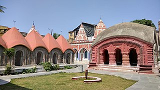
Malda district, also spelt Maldah or Maldaha, is a district in West Bengal, India. It lies 347 km north of Kolkata, the capital of West Bengal. Mango, jute and silk are the most notable products of this district. The special variety of mango, Fazli, produced in this region is popularly known by the name of the district and is exported across the world and is internationally acclaimed. The folk culture of gombhira is a feature of the district, being a unique way of representation of joy and sorrow in daily life of the common people, as well as the unique medium of presentation on national and international matters. According to the National Investigation Agency Malda is believed to be a hub of a fake currency racket. It is reported that 90 per cent of the fake currency that enters India originates in Malda.

<span class="mw-page-title-main">Balurghat</span> Town in West Bengal, India

Balurghat (pron:bʌlʊəˈgɑ:t) is a city and a municipality in the state of West Bengal, India. It is the district headquarter of the Dakshin Dinajpur district. It is one of the major cities connected through National Highway 512. In this town there are museum, parks, super speciality hospital, govt. offices, district court, schools, colleges, a university, police station, railway station, hotels, restaurants, cinema halls, temples, mosques, churches, etc. There is the Atreyee river which flows through this town. It is a place/town to live peacefully. It is a place to visit in the month of October to November when one can enjoy ritualistic and religious festivals. From the inner area of Balurghat one can go Hilli, a rural area, where one can see India-Bangladesh border.

<span class="mw-page-title-main">Raiganj</span> City in West Bengal, India

Raiganj is a city and a municipality in the Indian state of West Bengal. It is the headquarters of the Uttar Dinajpur district. The police station was set up 125 years ago and railway connectivity reached the place 115 years ago. The city houses the 111-year-old Raiganj Coronation High School and more than 50-years-old government primary Raiganj Sarala Sundari GSFP School. Raiganj got its railway connection in 1896. The train used to go to Parbatipur junction in Bangladesh from Raiganj. It is a 200-year-old town.

<span class="mw-page-title-main">Berhampore</span> City in West Bengal, India

Berhampore, also known as Baharampur, is a city and a municipality in the state of West Bengal, India. Berhampore is the administrative headquarters of the Murshidabad district. As of 2011 census, Berhampore is the seventh largest city in West Bengal. It is located about 200 km (124 mi) from Kolkata, the state capital.

<span class="mw-page-title-main">Dalkhola</span> City in West Bengal, India

Dalkhola is a city and a municipality of Uttar Dinajpur district in the state of West Bengal, India.

<span class="mw-page-title-main">Dhuliyan</span> Town in West Bengal, India

Dhuliyan is a municipality town in the Samserganj block of Jangipur subdivision of Murshidabad district in the state of West Bengal, India. This municipality was established in the year 1909 and comprises 21 wards. It is located between the Ganges and the Feeder canal.

<span class="mw-page-title-main">Mahiari</span> Census Town in West Bengal, India

Mahiari is a census town in Domjur CD Block of Howrah Sadar subdivision in Howrah district in the Indian state of West Bengal. It is a part of Kolkata Urban Agglomeration.

Old Malda is a census town in Malda district in the Indian state of West Bengal. It is a part of the Malda Metropolitan Area. It is located on the eastern bank of the river Mahananda.

<span class="mw-page-title-main">Gazole (community development block)</span> Community development block in West Bengal, India

Gazole is a community development block that forms an administrative division in Malda Sadar subdivision of Malda district in the Indian state of West Bengal.

<span class="mw-page-title-main">Malda Sadar subdivision</span> Subdivision in West Bengal, India

Malda Sadar subdivision is an administrative subdivision of the Malda district in the Indian state of West Bengal.

<span class="mw-page-title-main">Kaliachak I</span> Community development block in West Bengal, India

Kaliachak I is a community development block that forms an administrative division in Malda Sadar subdivision of Malda district in the Indian state of West Bengal.

<span class="mw-page-title-main">Manikchak</span> Community development block in West Bengal, India

Manikchak is a community development block that forms an administrative division in Malda Sadar subdivision of Malda district in the Indian state of West Bengal.

<span class="mw-page-title-main">Bamangola (community development block)</span> Community development block in West Bengal, India

Bamangola is a community development block that forms an administrative division in Malda Sadar subdivision of Malda district in the Indian state of West Bengal.

<span class="mw-page-title-main">Kaliachak III</span> Community development block in West Bengal, India 87.9776

Kaliachak III is a community development block that forms an administrative division in Malda Sadar subdivision of Malda district in the Indian state of West Bengal.

<span class="mw-page-title-main">Old Malda (community development block)</span> Community development block in West Bengal, India

Old Malda is a community development block that forms an administrative division in Malda Sadar subdivision of Malda district in the Indian state of West Bengal.

<span class="mw-page-title-main">English Bazar (community development block)</span> Community development block in West Bengal, India

English Bazar is a community development block that forms an administrative division in Malda Sadar subdivision of Malda district in the Indian state of West Bengal.

<span class="mw-page-title-main">Ratua II</span> Community development block in West Bengal, India

Ratua II is a Community Development Block that forms an administrative division in Chanchal subdivision of Malda district in the Indian state of West Bengal.

References

  1. "English Bazar Municipality". sudawb.org. Archived from the original on 27 July 2021. Retrieved 7 February 2024.
  2. 1 2 "Old Malda Municipality". sudawb.org. Archived from the original on 27 July 2021. Retrieved 7 February 2024.
  3. 1 2 3 4 "Provisional Population Totals, Census of India 2011; Cities having population 1 lakh and above" (PDF). Office of the Registrar General & Census Commissioner, India. Archived from the original (PDF) on 7 May 2012. Retrieved 27 March 2012.
  4. 1 2 "Fact and Figures". www.wb.gov.in. Retrieved 15 January 2019.
  5. "52nd Report of the Commissioner for Linguistic Minorities in India" (PDF). nclm.nic.in. Ministry of Minority Affairs. p. 85. Archived from the original (PDF) on 25 May 2017. Retrieved 15 January 2019.
  6. "Urban Agglomerations/Cities having population 1 lakh and above" (PDF). Provisional Population Totals, Census of India 2011. Retrieved 10 October 2011.
  7. Yule, Henry; Burnell, Arthur (1903). "E". Hobson-Jobson (New ed.). London: William Crooke, B.A. p. 344. English-Bazar
  8. "Maps, Weather, and Airports for Ingraj Bazar,India". fallingrain.com.
  9. "Station: Malda, Climatological Table 1981–2010" (PDF). Climatological Normals 1981–2010. India Meteorological Department. January 2015. pp. 465–466. Archived from the original (PDF) on 5 February 2020. Retrieved 10 January 2021.
  10. "Climate for Malda city" . Retrieved 19 October 2020.
  11. "Extremes of Temperature & Rainfall for Indian Stations (Up to 2012)" (PDF). India Meteorological Department. December 2016. p. M238. Archived from the original (PDF) on 5 February 2020. Retrieved 19 October 2020.
  12. "Provisional Population Totals, Census of India 2011; Urban Agglomerations/Cities having population 1 lakh and above" (PDF). Office of the Registrar General & Census Commissioner, India. Retrieved 27 March 2012.
  13. "Census of India 2001: Data from the 2001 Census, including cities, villages and towns (Provisional)". Census Commission of India. Archived from the original on 16 June 2004. Retrieved 1 November 2008.
  14. "C-1 Population By Religious Community". census.gov.in. Retrieved 27 December 2020.
  15. Maitra, Subhro (25 March 2015). "Battle of couples in Malda civic polls". The Times of India. Retrieved 19 September 2023.

Further reading

Wikivoyage-Logo-v3-icon.svg Gour-Pandua travel guide from Wikivoyage