Maloy, Iowa | |
---|---|
Coordinates: 40°40′23″N94°24′43″W / 40.67306°N 94.41194°W | |
Country | United States |
State | Iowa |
County | Ringgold |
Government | |
• Mayor | Betsy Keenan |
Area | |
• Total | 0.63 sq mi (1.62 km2) |
• Land | 0.62 sq mi (1.61 km2) |
• Water | 0.01 sq mi (0.01 km2) |
Elevation | 1,119 ft (341 m) |
Population (2020) | |
• Total | 22 |
• Density | 35.43/sq mi (13.68/km2) |
Time zone | UTC-6 (Central (CST)) |
• Summer (DST) | UTC-5 (CDT) |
ZIP code | 50836 [3] |
Area code | 641 |
FIPS code | 19-48675 |
GNIS feature ID | 2395824 [2] |
Maloy is a city in southwest Ringgold County, Iowa, United States, along the Little Platte River. The population was 22 at the time of the 2020 census. [4]
Settlement of the western part of Ringgold County began in the 1850s. Maloy was platted in 1887, in the same year as the railroad arrived. Maloy was incorporated as a city in 1901. In 1917, the two-story brick Maloy High School was built; after serving from 1920 to 1952, it became an elementary school in the Mount Ayr Community School District.[ citation needed ]
A major fire on June 17, 1931, razed the Catholic Church, five businesses, a house, and a barn. [5] The school closed in 1972 and was torn down in 1987. The railroad, which once offered both freight and passenger service, was dismantled in 1985.[ citation needed ]
Maloy is on Iowa County Road J43 approximately ten miles west-southwest of Mount Ayr. The Little Platte River flows past the west side of the community. [6]
According to the United States Census Bureau, the city has a total area of 0.62 square miles (1.61 km2), all land. [7]
Year | Pop. | ±% |
---|---|---|
1910 | 127 | — |
1920 | 121 | −4.7% |
1930 | 112 | −7.4% |
1940 | 95 | −15.2% |
1950 | 90 | −5.3% |
1960 | 68 | −24.4% |
1970 | 45 | −33.8% |
1980 | 38 | −15.6% |
1990 | 36 | −5.3% |
2000 | 28 | −22.2% |
2010 | 29 | +3.6% |
2020 | 22 | −24.1% |
Source: "U.S. Census website". United States Census Bureau . Retrieved March 29, 2020. and Iowa Data Center Source: |
As of the census [9] of 2010, there were 29 people in 12 households, including 10 families, in the city. The population density was 46.8 inhabitants per square mile (18.1/km2). There were 15 housing units at an average density of 24.2 per square mile (9.3/km2). The racial makup of the city was 100.0% White.
Of the 12 households 33.3% had children under the age of 18 living with them, 75.0% were married couples living together, 8.3% had a male householder with no wife present, and 16.7% were non-families. 16.7% of households were one person and 8.3% were one person aged 65 or older. The average household size was 2.42 and the average family size was 2.60.
The median age was 42.5 years. 20.7% of residents were under the age of 18; 13.7% were between the ages of 18 and 24; 24% were from 25 to 44; 20.5% were from 45 to 64; and 20.7% were 65 or older. The gender makeup of the city was 62.1% male and 37.9% female.
As of the census [10] of 2000, there were 28 people in 10 households, including 7 families, in the city. The population density was 45.1 inhabitants per square mile (17.4/km2). There were 11 housing units at an average density of 17.7 per square mile (6.9/km2). The racial makup of the city was 100.00% White.
Of the 10 households 50.0% had children under the age of 18 living with them, 50.0% were married couples living together, 10.0% had a female householder with no husband present, and 30.0% were non-families. 20.0% of households were one person and 10.0% were one person aged 65 or older. The average household size was 2.80 and the average family size was 3.29.
The age distribution was 32.1% under the age of 18, 7.1% from 18 to 24, 28.6% from 25 to 44, 14.3% from 45 to 64, and 17.9% 65 or older. The median age was 36 years. For every 100 females, there were 86.7 males. For every 100 females age 18 and over, there were 90.0 males.
The median income for a household in the city is $36,250, and the median family income was $13,750. Males had a median income of $16,250 versus $11,875 for females. The per capita income for the city was $10,386. There were 50.0% of families and 42.9% of the population living below the poverty line, including 55.6% of under eighteens and none of those over 64.
Mount Ayr Community School District operates public schools serving the community. [11]
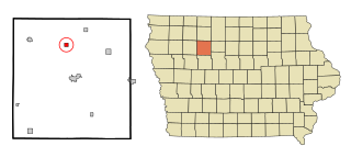
Ringgold County is a county located in the U.S. state of Iowa. As of the 2020 census, the population was 4,663, making it the Iowa county with the second-smallest population. The county seat is Mount Ayr. The county is named after Maj. Samuel Ringgold, a hero of the Battle of Palo Alto fought in May 1846, during the Mexican–American War. It is one of the 26 Iowa counties with a name that is unique across the nation.
Shellsburg is a city in Benton County, Iowa, United States. The population was 961 at the time of the 2020 census. It is part of the Cedar Rapids Metropolitan Statistical Area.
Rinard is a city in Calhoun County, Iowa, United States. The population was 38 at the time of the 2020 census.
Grand River is a city in northwest Decatur County, Iowa, United States. The population was 196 at the time of the 2020 census.
Paton is a city in Greene County, Iowa, United States. The population was 221 at the time of the 2020 census.
Oxford Junction is a city in Jones County, Iowa, United States. The population was 424 at the time of the 2020 census. It is part of the Cedar Rapids Metropolitan Statistical Area.
Wyoming is a city in Jones County, Iowa, United States. The population was 523 at the time of the 2020 census. It is part of the Cedar Rapids Metropolitan Statistical Area.
Cotter is a city in western Louisa County, Iowa, United States. The population was 39 at the 2020 census. It is part of the Muscatine Micropolitan Statistical Area.
Havelock is a city in Pocahontas County, Iowa, United States. The population was 130 at the time of the 2020 census.
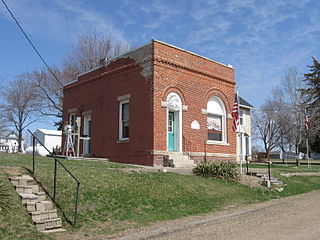
Beaconsfield is a city in Ringgold County, Iowa, United States. The population was 15 in the 2020 census, unchanged from 2010 and an increase from 11 in 2000. In the 2000 census Beaconsfield was the least populated incorporated city in Iowa; with the increase in the 2020 census, it is now the second smallest, after Le Roy.
Benton is a city in Ringgold County, Iowa, United States. The population was 39 at the 2020 census.
Delphos is a former city in Ringgold County, Iowa, United States. The population was 26 at the 2020 census. In 2017 the community of Delphos voted to disincorporate. This was approved by the Ringgold County Board of Supervisors in 2018.
Kellerton is a city in eastern Ringgold County, Iowa, United States. The population was 243 at the time of the 2020 census.
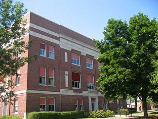
Mount Ayr is a city in Ringgold County, Iowa, United States. The population was 1,988 at the time of the 2020 census. It is the county seat of Ringgold County. Mount Ayr is a rural community in southwestern Iowa, 22 miles west of Interstate 35 on State Highway 2. Mount Ayr was founded in 1875 and the community was named in honor of poet Robert Burns’ birthplace in Ayr, Scotland. The “mount” was added to indicate its location on the highest point of land in the area.
Redding is a city in southwest Ringgold County, Iowa, United States. The population was 63 at the time of the 2020 census.
Tingley is a city in northern Ringgold County, Iowa, United States. The population was 136 at the time of the 2020 census.
Westphalia is a city in Shelby County, Iowa, United States. The population was 126 at the time of the 2020 census.
Crawfordsville is a city in Washington County, Iowa, United States. It is part of the Iowa City, Iowa Metropolitan Statistical Area. The population was 277 at the 2020 census.
West Chester is a city in Washington County, Iowa, United States. It is part of the Iowa City, Iowa Metropolitan Statistical Area. The population was 144 at the time of the 2020 census.
Castalia is a city in Winneshiek County, Iowa, United States. The population was 145 at the 2020 census.