Malpas, Newport

Last updated

Malpas
Hilly Malpas, Newport - geograph.org.uk - 1742825.jpg
Newport UK location map.svg
Red pog.svg
Malpas
Location within Newport
Population7,997 (2011) [1]
Language English
Cymraeg (Welsh)
OS grid reference ST305908
Principal area
Country Wales
Sovereign state United Kingdom
Post town NEWPORT
Postcode district NP20 6
Dialling code 01633
Chartist exchange
Police Gwent
Fire South Wales
Ambulance Welsh
UK Parliament
Senedd Cymru – Welsh Parliament
List of places
UK
Wales
Newport
51°36′42″N3°00′18″W / 51.61172°N 3.00509°W / 51.61172; -3.00509

Malpas is an electoral district (ward) and coterminous community (parish) of the city of Newport, South Wales. The area is governed by the Newport City Council. [2]

Contents

Boundaries

The ward is bounded by the A4042 Heidenheim Drive to the east, the city boundary to the north, Malpas brook to the west, and Bettws Lane, Llanover Close, and the western and northern edges of Graig Wood, Yewberry Lane and Grove Park Drive to the south.

Name origin

The name is French and comes from Mal (bad/poor) and Pas (passage/way). Earlier examples of the name include the definite article 'Le' and even an odd Welsh definite article 'Y' i.e. Le Malpas, Y Malpas.

The community

There are two large housing estates either side of the main Malpas Road (A4051). To the west is Hollybush and the council estates of Westfield and Malpas Court, although many of the houses are now in private ownership. To the east are the privately owned estates Woodlands, Malpas Park, Pilton Vale and Claremont. The roads in Malpas Court take their names from famous inventors and scientists, while those in Malpas Park are named after trees. The roads in Woodlands are named after World War II generals, e.g. Allenbrooke Avenue, Horrocks Close, Montgomery Road, Robertson Way, Wavell Drive, etc. Claremont and Pilton Vale however are just single street names with large house numbers.

The Malpas Institute Trust is a charitable fund, founded on the sale of the World War I Memorial Institute. [3]

There are four primary schools in the ward: Malpas Church in Wales Primary, [4] Malpas Court, [5] and Malpas Park. [6]

There are three Christian churches in Malpas, St. Mary's Church in Wales, Trinity Presbyterian, and St. Anne's Roman Catholic. The fourth Malpas Church, Christchurch, [7] which is just off the Old Malpas Road is in the Shaftesbury Ward. There are no formal places of worship for other religions or faiths.

Malpas is also home to St Joseph's Hospital, Newport, one of Wales's largest private hospitals, and an in-patient hospice service, St Anne's Hospice, [8] both originally run by the Sisters of St. Joseph of Annecy. [9] Since 2013 the hospice has been run by St David's Foundation Hospice Care, [10] whilst the hospital was taken over by a consortium of businessmen and doctors in July 2014. [11]

There is a detachment for Gwent & Powys Army Cadet Force near Oliphant Circle. [12]

A station of South Wales Fire and Rescue Service is located in Malpas.

Cycling and walking

A cycle and pedestrian walkway alongside the River Usk links Malpas to Caerleon and Newport city centre at Crindau. [13]

Related Research Articles

<span class="mw-page-title-main">Caerleon</span> Town and community in Newport, Wales

Caerleon is a town and community in Newport, Wales. Situated on the River Usk, it lies 5 miles (8 km) northeast of Newport city centre, and 5.5 miles (9 km) southeast of Cwmbran. Caerleon is of archaeological importance, being the site of a notable Roman legionary fortress, Isca Augusta, and an Iron Age hillfort. Close to the remains of Isca Augusta are the National Roman Legion Museum and the Roman Baths Museum. The town also has strong historical and literary associations: Geoffrey of Monmouth elevated the significance of Caerleon as a major centre of British history in his Historia Regum Britanniae, and Alfred Lord Tennyson wrote Idylls of the King (1859–1885) while staying in Caerleon.

<span class="mw-page-title-main">Cwmbran</span> Human settlement in Wales

Cwmbran is a town in the county borough of Torfaen in South Wales.

<span class="mw-page-title-main">Newport, Wales</span> City and county borough in Wales

Newport is a city and county borough in Wales, situated on the River Usk close to its confluence with the Severn Estuary, 12 mi (19 km) northeast of Cardiff. The population grew considerably between the 2011 and the 2021 census, rising from 145,700 to 159,587, the largest growth of any unitary authority in Wales. Newport is the third-largest principal authority with city status in Wales, and sixth most populous overall. Newport became a unitary authority in 1996 and forms part of the Cardiff-Newport metropolitan area, also known as the Cardiff Capital Region.

<span class="mw-page-title-main">Newport City Council</span> Local government of Newport, Wales

Newport City Council is the governing body for Newport, one of the principal areas of Wales. It consists of 51 councillors, who represent the city's 20 wards.

<span class="mw-page-title-main">Lliswerry</span> Human settlement in Wales

Lliswerry, or Liswerry is an electoral district (ward) and community of the city of Newport, South Wales. The area is governed by Newport City Council. It is the largest community/ward in the city.

St Julians is a community and coterminous electoral district (ward) of the City of Newport, South Wales.

<span class="mw-page-title-main">Bettws, Newport</span> Human settlement in Wales

Bettws is a large modern housing estate, electoral ward and coterminous community (parish) of the city of Newport, South Wales.

<span class="mw-page-title-main">Langstone, Newport</span> Human settlement in Wales

Langstone is a community and village of the city of Newport, Wales. The area is governed by the Newport City Council. The community had a population of 3,279 in 2011.

Newport Poor Law Union was a health and social security organisation in Newport, Monmouthshire and surrounding parishes. It was formed on 1 August 1836 under the Poor Law Amendment Act 1834 and was composed of 40 constituent parishes:

<span class="mw-page-title-main">Christchurch, Newport</span> Human settlement in Wales

Christchurch is a village located at the top of Christchurch Hill in the Caerleon ward and community of the city of Newport, South Wales. The top of the hill affords panoramic views both towards the Bristol Channel in the south and through the Vale of Usk and into the Monmouthshire countryside to the north. The road, which runs along the crest of the hill, runs westwards to Newport and eastwards towards Caerleon and Catsash.

<span class="mw-page-title-main">Crindau</span> Human settlement in Wales

Crindau is a Victorian inner-city area just north of the city centre in Newport in south-east Wales. It lies within the Shaftesbury electoral district (ward) and community (parish).

The Newport and District Football League is a football league covering the city of Newport and surrounding areas in South Wales. The headquarters are located at Newport Civic Centre.

The Newport Deanery is a Roman Catholic deanery in the Archdiocese of Cardiff that covers several churches in Newport and Monmouthshire, Wales.

<span class="mw-page-title-main">Aneurin Bevan University Health Board</span> NHS local health board in South East Wales

Aneurin Bevan University Health Board (ABUHB) is the local health board of NHS Wales for Gwent, in the south-east of Wales. Headquartered in Caerleon, the local health board (LHB) was launched in October 2009 through the merger of Gwent Healthcare NHS Trust and Blaenau Gwent, Caerphilly, Newport, Torfaen, and Monmouthshire LHBs. It is named after Aneurin Bevan, a Member of Parliament who represented the area and who was the Minister of Health responsible for the foundation of the National Health Service. Aneurin Bevan University Health Board is the operational name of Aneurin Bevan Local Health Board.

<span class="mw-page-title-main">St Cadoc's Church, Caerleon</span>

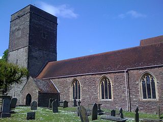
St Cadoc's Church is a Church in Wales church located in Caerleon, Newport, Wales and is Grade II* listed. It is one of many buildings associated with the travels of St Cadoc.

Riverside is a mixed residential and commercial area close to Newport city centre, South Wales.

<span class="mw-page-title-main">St Joseph's Hospital, Newport</span> Hospital in Newport, Wales

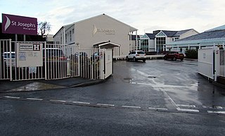
St Joseph's Hospital is one of the largest privately owned hospitals in Wales. It is situated on Harding Avenue, Malpas, Newport.

<span class="mw-page-title-main">Pil (placename)</span> Placename element in Brythonic languages

Pîl is a Welsh placename element. The name is defined as the tidal reach of a waterway, suitable as a harbour, and is common along the Bristol Channel and Severn Estuary. The highly localised distribution suggests it may have been part of a common maritime culture on the waterways within the tidal reach of the Severn Sea.

References

  1. "Community Well-being Profile" (PDF). newport.gov.uk. May 2017.
  2. "Councillors". democracy.newport.gov.uk. 1 March 2022.
  3. "A new life: How the trust was restarted". malpas-trust.com.
  4. "Malpas Church in Wales Primary School". mylocalschool.gov.wales.
  5. "Malpas Court Primary". mylocalschool.gov.wales.
  6. "Malpas Park Primary". mylocalschool.gov.wales.
  7. "Welcome to Christchurch | Christchurch Newport Wales". Ephesians | Christchurch.
  8. "Welcome to St Anne's Hospice". st anne's hospice.
  9. "Celebration of 75th anniversary of foundation of St. Joseph Hospital, Malpas".
  10. "From humble beginnings to caring for thousands - St David's Hospice Care is 40 this year". South Wales Argus.
  11. "Newport private hospital St Joseph's sold to team of consultants and investors in a deal worth £10m". Wales Online. 28 July 2014.
  12. "Gwent And Powys Army Cadets". Army Cadets UK.
  13. "'Vital' Caerleon cycle link opens". South Wales Argus.