Caerleon is a town and community in Newport, Wales. Situated on the River Usk, it lies 5 miles (8 km) northeast of Newport city centre, and 5.5 miles (9 km) southeast of Cwmbran. Caerleon is of archaeological importance, being the site of a notable Roman legionary fortress, Isca Augusta, and an Iron Age hillfort. Close to the remains of Isca Augusta are the National Roman Legion Museum and the Roman Baths Museum. The town also has strong historical and literary associations: Geoffrey of Monmouth elevated the significance of Caerleon as a major centre of British history in his Historia Regum Britanniae, and Alfred Lord Tennyson wrote Idylls of the King (1859–1885) while staying in Caerleon.

Chepstow is a town and community in Monmouthshire, Wales, adjoining the border with Gloucestershire, England. It is located on the tidal River Wye, about 2 miles (3 km) above its confluence with the River Severn, and adjoining the western end of the Severn Bridge. It is the easternmost settlement in Wales, situated 16 miles (26 km) east of Newport, 28 miles (45 km) east-northeast of Cardiff, 18 miles (29 km) northwest of Bristol and 110 miles (180 km) west of London.

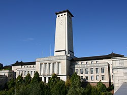
Newport is a city and county borough in Wales, situated on the River Usk close to its confluence with the Severn Estuary, 12 mi (19 km) northeast of Cardiff. With a population of 145,700 at the 2011 census, Newport is the third-largest authority with city status in Wales, and seventh most populous overall. Newport became a unitary authority in 1996 and forms part of the Cardiff-Newport metropolitan area. Newport was the site of the last large-scale armed insurrection in Great Britain, the Newport Rising of 1839. The population grew considerably during the 2021 census, rising to 159,587, the largest growth of a unitary authority in Wales.

The Sessions House at Usk, Wales, is a Victorian courthouse by Thomas Henry Wyatt of 1877. It is a Grade II* listed building as of 4 January 1974.

The Shire Hall in Agincourt Square, Monmouth, Wales, is a prominent Grade I listed building in the town centre. It was built in 1724, and was formerly the centre for the Assize Courts and Quarter Sessions for Monmouthshire. In 1839–40, the court was the location of the trial of the Chartist leader John Frost and others for high treason for their part in the Newport Rising. The building was also used as a market place. The Shire Hall is owned by Monmouthshire County Council and has audiovisual guides for visitors to Courtroom 1. It is currently used as a Tourist Information Centre and as the offices for Monmouth Town Council, and is open to the public in part.

The Church of St Thomas the Martyr at Overmonnow, Monmouth, south east Wales, is located beside the medieval Monnow Bridge across the River Monnow. At least part of the building dates from around 1180, and it has a fine 12th-century Norman chancel arch, though the exterior was largely rebuilt in the early 19th century. It is one of 24 buildings on the Monmouth Heritage Trail and is a Grade II* listed building.
The Rolls Hall, Whitecross Street, Monmouth, Monmouthshire is a Victorian hall, now public library, donated to the town in celebration of Queen Victoria's Golden Jubilee by John Rolls, the future Lord Llangattock. It is a Grade II listed building as of 8 October 2005, and is one of 24 buildings on the Monmouth Heritage Trail.

The Market Hall, in Priory Street, Monmouth, Wales, is an early Victorian building by the prolific Monmouth architect George Vaughan Maddox. It was constructed in the years 1837–39 as the centrepiece of a redevelopment of part of Monmouth town centre. After being severely damaged by fire in 1963, it was partly rebuilt and is now the home of Monmouth Museum. At the rear of the building are original slaughterhouses, called The Shambles, opening onto the River Monnow. The building is Grade II listed as at 27 June 1952, and it is one of 24 buildings on the Monmouth Heritage Trail. The Shambles slaughterhouses are separately listed as Grade II*.

George Vaughan Maddox was a nineteenth-century British architect and builder, whose work was undertaken principally in the town of Monmouth, Wales, and in the wider county. Working mainly in a Neo-Classical style, his extensive output made a significant contribution to the Monmouth townscape. The architectural historian John Newman considers that Monmouth owes to Maddox "its particular architectural flavour. For two decades from the mid-1820s he put up a sequence of public buildings and private houses in the town, in a style deft, cultured, and only occasionally unresolved." The Market Hall and 1-6 Priory Street are considered his "most important projects".

Hilston Park is a country house and estate between the villages of Newcastle and Skenfrith in Monmouthshire, Wales, close to the border with Herefordshire, England. The house and park are in the Monnow valley, beside the B4347 road, 7.9 miles (12.7 km) by road northwest of Monmouth and just over 1 mile (1.6 km) southwest of Skenfrith.
Kingsley House and Hendre House are a pair of 19th-century, semi-detached houses on the North Parade section of Monk Street in Monmouth, Monmouthshire, Wales. The grade II listed houses were designed by noted Monmouth architect and builder George Vaughan Maddox, who also designed at least two of the twenty-four blue plaque buildings on the Monmouth Heritage Trail, including the Market Hall and the Monmouth Methodist Church. Hendre House should be distinguished from The Hendre, the estate of the Rolls family.

Glendower Street is a historic street in the town centre of Monmouth, Monmouthshire, Wales. It extends to the southeast from the intersection of Agincourt Street and St John's Street, within the medieval town walls. Glendower Street is lined with numerous listed buildings, including one of the 24 blue plaque buildings on the Monmouth Heritage Trail.

Habershon & Fawckner or Habershon, Pite & Fawckner was a British architectural practice active in England and Wales from the 1860s, particularly in Cardiff and the South Wales area. They had had offices in London, Cardiff and Newport, designing a large number of houses, villas and non-conformist chapels.
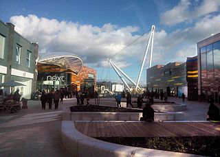
John Frost Square is a large public space in the centre of Newport, South Wales, named after the Chartist leader, John Frost. It was redeveloped as part of the Friars Walk shopping and leisure complex in 2014 and 2015.

Commercial Street is a 700-yard (660-metre) long main shopping street leading from the city centre of Newport, South Wales.

The Stable Block at Tredegar House forms part of the complex of buildings at Tredegar House, at Coedkernew, on the western edge of the city of Newport, Wales. The Stables were built by Thomas Morgan, son of William Morgan, who had rebuilt the main house as a "grand(.), classical house" between 1664 and 1672. Newman describes the stables as "match(ing) the house in scale and splendor" and the Stable Block, and attached orangery, were listed Grade I on 3 January 1963. and have been in the care of the National Trust since March 2012.
Gwent County Council was the upper-tier local authority that governed the county of Gwent in South Wales from its creation in 1974 to its abolition in 1996. For most of its existence, the county council was based in Cwmbran.

County Hall, Cwmbran was a municipal facility on Turnpike Road in Croesyceiliog in Cwmbran in Wales. It was the headquarters of Gwent County Council from 1978 to 1996 and of Monmouthshire County Council from 1996 to 2013.

Grosmont Town Hall is a municipal building in Grosmont, Monmouthshire, Wales. The structure, which is the meeting place of Grosmont Community Council, is a Grade II listed building.

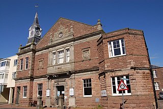
The Old Town Hall is a municipal building in Old Market Street, Usk, Monmouthshire, Wales. The structure, which is now used as the local club of the Royal British Legion, is a Grade II listed building.