
Cocos Island is an island 1 mile (1.6 km) off the southern tip of the United States territory of Guam, located within the Merizo Barrier Reef, part of the municipality of Merizo. The island is uninhabited, 1,600 meters (5,200 ft) long in a southwest-northeast direction, between 200 m (660 ft) and 300 m (980 ft) wide, and has an area of 386,303 m2. It sits atop the southwestern coral reef rim of Cocos Lagoon.

This is a list of the buildings, sites, districts, and objects listed on the National Register of Historic Places in Guam. There are currently 134 listed sites spread across 17 of the 19 villages of Guam. The villages of Agana Heights and Mongmong-Toto-Maite do not have any listings. Listed historic sites include Spanish colonial ruins, a few surviving pre-World War II ifil houses, Japanese fortifications, two massacre sites, and a historic district. Two other locations that were previously listed have been removed from the Register.

The following is an alphabetical list of articles related to the United States Territory of Guam.

Orote Field is a former air base in the United States territory of Guam built by the Empire of Japan with Chamorro forced labor during the Japanese occupation of Guam (1941-1944). It is separate from the Marine Corps amphibious airplane base at located at Sumay village that was operational from 1921 to 1931. Following the liberation of Guam in 1944, the U.S. military repaired the field for further use in the Pacific War. Located on Naval Base Guam, Orote Field was largely abandoned after World War II except for occasional training exercises. One major event in 1975 was Operation New Life, when a tent city for tens of thousands of South Vietnamese refugees was erected at the field. The field was listed on the National Register of Historic Places in 1975.
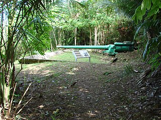
The Piti Guns or Piti Coastal Defense Guns is the site of three Vickers-type Model 3 140-millimetre (5.5 in) coastal defense guns in the War in the Pacific National Historical Park in Piti, Guam. The Japanese manufactured these Model 3 coastal defense guns in 1914. During the Japanese Occupation of Guam from 1941 to 1944, they built up defensive positions on the island. The Chamorro population was forced to work in building up these defenses, and did so here at the Piti Guns.

Malesso is the southernmost village in the United States territory of Guam. Cocos Island is a part of the municipality. The village's population has decreased since the island's 2000 census.
The Guam Congress Building, also known as the Guam Legislature Building, is the seat of the Legislature of Guam and is located in Chalan Santo Papa in Hagåtña, Guam. It was built in 1949 by Pacific Island Buildings and of Brown & Root Pacific Bridge & Maxon. It has served as a capitol and as a courthouse building. It is a Modern Movement-style building that was listed on the U.S. National Register of Historic Places in 2007.
Toves House, on Marine Dr. in the Anigua district of Hagåtña, Guam, was built in 1950, built mostly with ifil hardwood. It was a work of Pedro T. Toves in Pacific Spanish-Colonial vernacular architecture. It was listed on the National Register of Historic Places in 1985.
The Tinta Massacre Site, near Merizo, Guam, has significance from 1944. Also known as Tinta (66-06-1223), it was listed on the National Register of Historic Places in 1991. The listing included one contributing site and one contributing object.
The Merizo Bell Tower, on Guam Highway 4 in Merizo, Guam, is a bell tower that was built in 1914 or 1919. It was listed on the U.S. National Register of Historic Places in 1975.
The Guam Institute, located off in Guam Highway 1 in Hagåtña (Agana), Guam, was listed on the U.S. National Register of Historic Places in 1977; the listing included one contributing building. It was built in 1911. It has also been known as the Jose P. Lujan House.
The Mesa House, or Dr. Mesa House, is a historic house on Maxwell St. in Hagåtña, Guam.
The Agana Historic District in Hagåtña, Guam is a 2-acre (0.81 ha) historic district that was listed on the U.S. National Register of Historic Places in 1985. It includes five contributing buildings: the Calvo-Torres, Rosario, Martinez-Notley, Lujan and Leon Guerrero houses. The area is roughly bounded by 2nd S., 3rd S., and 9th W., Santa Cruz and Legaspi Sts. in Agana.

The Commissioner's Office is a rare surviving example of transitional Spanish-Japanese architecture on the island of Rota in the Northern Mariana Islands, an insular area of the United States in the western Pacific Ocean. It is a single-story structure with walls of manposteria, a construction method adopted during the Spanish period. The window trim consists of ifil lintels, and the building's cornice is Japanese in style. At the time of the building's listing on the National Register of Historic Places in 1981, it was in deteriorated condition, lacking a roof and with one collapsed wall. The structure was built in the 1930s by the local Chamorro people, who had been displaced to that part of the island by Japanese settlement undertaken as part of the South Seas Mandate. The building housed the offices of a local commissioner, or village head responsible to the Japanese authorities. Many buildings built by the Japanese during the mandate period were destroyed in World War II.
The Faha Massacre Site is located just behind the Pigua cemetery in the village of Merizo on the United States island of Guam. The site is demarcated by four concrete pillars, connected by metal cables, with several crosses placed inside that area. A metal plaque mounted on a concrete block commemorates the thirty native Chamorro men who were slaughtered here on July 16, 1944, by members of the Imperial Japanese Army (IJA) during the Japanese occupation of the island during World War II. The IJA routinely forced Guam's native population to work on its construction projects. The men who were killed here were rounded up for a work crew; why they were killed is unclear, as there were no survivors. The massacre took place one day after the Tinta Massacre, and about one week before the liberation of the island began.
The Malessu' Pillbox is a World War II-era Japanese-built defensive fortification on the shore of Merizo, Guam. Located about 15 metres (49 ft) from the high-tide line at Merizo Beach, it is a rectangular structure built of steel-reinforced concrete and basalt rock. It is 3.9 metres (13 ft) deep, 2.4 metres (7.9 ft) wide, and about 2.42 metres (7.9 ft) high, although only about 0.75 metres (2.5 ft) of the structure is visible above ground. Its gun port has a view of the Merizo pier, and is approximately at ground level. It was built by Japanese defenders during their occupation of the island 1941–44.
The Malesso Japanese Rice Mill is a historic World War II-era storage building in Merizo, Guam. It is a single-story concrete structure with two rooms, located on a small parcel in a residential area south of Guam Highway 4 off Barcinas Road. The concrete was made of locally sourced aggregate and lime. It was completed on December 24, 1943, by conscripted Chamorro labor working for the occupying Japanese authorities. It was built as part of a project by the Japanese to improve rice production in the area during the later period of the occupation. There is no evidence that the building was intended to house facilities for milling rice, although it has always been referred to locally as a rice mill. It is the only known non-military structure to survive on the island from the Japanese occupation period.

Gadao's Cave, also known as Liyang Gadao, is a rock art site on the United States island of Guam. Located near the village of Inarajan, the cave is the site of a panel of approximately 50 Chamorro pictographs, painted with a mixture of coral lime and tree sap. The most unusual images are of two human stick figures that appear to be carrying things. It is not known who painted them or when, and what their significance is. The legendary chief of Inarajan Gadao is believed to be the creator of the cave's images.
The Mana Pillbox is an old World War II-era Japanese-built defensive fortification on the east coast of the island of Guam. It is located south of the village of Talofofo, about 50 metres (160 ft) inland from the point marking the south end of As Anite Cove. It is a structure built out of coral limestone and concrete, with an interior chamber about 3 by 1.8 metres in size. The entrance is on the south side, measuring 0.85 by 1.45 metres. There is one gun port, facing north, measuring 0.32 by .9 metres. The structure was designed to be well hidden in view from the sea and air. It was built, probably by conscripted Chamorro labor, during the Japanese occupation period 1941–44.
The Merizo Conbento is a historic building on Guam Route 4 in Merizo, Guam. Built in 1856, it is the oldest known occupied building on the island. It is a two-story concrete and ifil-wood structure with a gabled corrugated-metal roof, and a large set of concrete stairs leading to the main level above a raised basement. The present-day exterior is a faithful representation of the building's original appearance (with the exception of the roofing material, and original walls of manposteria remain inside the structure. It was built as a parish house for the local Roman Catholic diocese, and saw use as a military post and prison during the Japanese occupation period during World War II.


