
Clarke County is a county in the Commonwealth of Virginia. As of the 2020 census, the population was 14,783. Its county seat is Berryville. Clarke County is included in the Washington-Arlington-Alexandria, DC-VA-MD-WV Metropolitan Statistical Area.

Boyce is a town in Clarke County, Virginia, United States. The population was 749 at the 2020 census, up from 589 at the 2010 census.

Buildings, sites, districts, and objects in Virginia listed on the National Register of Historic Places:

State Route 255 is a primary state highway in the U.S. state of Virginia. Known as Bishop Meade Highway, the state highway runs 3.84 miles (6.18 km) from U.S. Route 17 and US 50 near Millwood north to US 340 at Briggs in southern Clarke County.

Saratoga, also known as the General Daniel Morgan House, is a historic plantation house near Boyce, Virginia. It was built in 1779 by Daniel Morgan, a general in the Continental Army best known for his victory over the British at the Battle of Cowpens in 1781. He named his estate after the American victory in the 1777 Battles of Saratoga, in which he also participated. The estate was listed on the National Register of Historic Places in 1970 and was declared a National Historic Landmark in 1973. Privately owned, it is located about .5 miles south of Boyce on the west side of County Route 723, and is not open to the public.

Carter Hall was the Millwood, Virginia, USA estate of Lt. Col. Nathaniel Burwell (1750–1814). It is located in the upper Shenandoah Valley, off Virginia Route 255 northeast of Millwood. The estate includes a grand plantation house, a great lawn, and terraced gardens, and has panoramic views in all directions. It is listed on the National Register of Historic Places.

The Upper Historic District is a historic district encompassing the historic center of Washington, Massachusetts. Centered on the junction of Washington Mountain Road and Branch Road, the town center flourished from the town's establishment in the 1750s until the center of the town's business moved closer to the newly lain railroad in the 1830s. The district includes the old town hall, cemetery, common, and pound, as well as a number of residences. A meeting house (church) and schoolhouse once stood in the area, but the 1792 church was destroyed by lightning in 1859, and the schoolhouse is no longer extant. The district was added to the National Register of Historic Places in 1987.

Long Branch is a historic family seat in Millwood, Virginia built in the early 19th century; named after the creek that runs through the property. Built on approximately 1000 acres by Robert Carter Burwell in 1811 and owned by the Burwell-Nelson family until 1957. The property was placed on the National Register on October 1, 1969.
Hope Park was an 18th and 19th-century plantation in Fairfax County in the U.S. state of Virginia, where Dr. David Stuart (1753–1814), an old friend of and correspondent with George Washington lived with his wife, Eleanor Calvert Custis (1758–1811), and family. It was approximately 5 miles (8.0 km) southwest of Fairfax Court House.
The Burwells were among the First Families of Virginia in the Colony of Virginia. John Quincy Adams once described the Burwells as typical Virginia aristocrats of their period: forthright, bland, somewhat imperious and politically simplistic by Adams' standards. In 1713, so many Burwells had intermarried with the Virginia political elite that Governor Spotswood complained that " the greater part of the present Council are related to the Family of Burwells...there will be no less than seven so near related that they will go off the Bench whenever a Cause of the Burwells come to be tried."

Nathaniel Burwell was an American politician and plantation owner. Perhaps the most distinguished of five men of that name to serve in the Virginia General Assembly before the American Civil War, this Nathaniel Burwell won election to the Virginia House of Delegates as well as the Virginia Ratifying Convention, and also served as the county lieutenant for the James City County militia.
Wickliffe Church is a historic Episcopal church building located in Berryville, Clarke County, Virginia. The church has not been in active use since 1918, except for an annual homecoming service held in August and occasional special events.

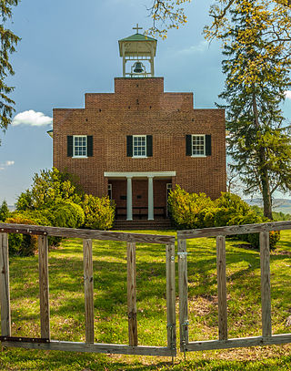
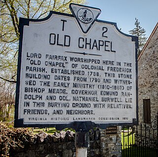
Old Chapel is a historic Episcopal church building located near Millwood, Clarke County, Virginia. Old Chapel is now the oldest Episcopal church building still in use west of the Blue Ridge Mountains. It was listed on the National Register of Historic Places in 1973. In 2014, the Chapel Rural Historic District was recognized, and which encompasses both Cunningham parish churches, discussed below, as well as approximately 700 other structures and an area of nearly 10,500 acres.
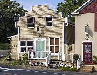
Millwood Commercial Historic District is a national historic district located at Millwood, Clarke County, Virginia.

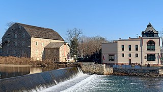
Burwell-Morgan Mill, also known as the Millwood Mill, is a historic grist mill located at Millwood, Clarke County, Virginia. It was built about 1785 by Gen. Daniel Morgan and Lt. Col. Nathaniel Burwell, who both served in the American Revolution. Burwell was the project's financier and Morgan managed the construction. The project overseer was L.H. Mongrul, whose initials and the date 1782 are carved in a stone in the mill's wall. The mill operated until the 1950s. In 1964 it was donated to the Clarke County Historical Association, which finished restoration in 1970 and operates the mill as a museum.

Old Pine Church, also historically known as Mill Church, Nicholas Church, and Pine Church, is a mid-19th century church located near to Purgitsville, West Virginia, United States. It is among the earliest extant log churches in Hampshire County, along with Capon Chapel and Mount Bethel Church.
The Chapel Rural Historic District is an expansive rural historic district in Clarke County, Virginia. The district encompasses an area of nearly 11,500 acres (4,700 ha), a rural landscape that extends from Millwood in the south, nearly to Berryville in the north. The district takes its name from the Old Chapel, an 18th-century building that stands prominently at the junction of several roads near the center of the district. The district includes nearly 700 contributing properties.
The Civil War Trust's Civil War Discovery Trail is a heritage tourism program that links more than 600 U.S. Civil War sites in more than 30 states. The program is one of the White House Millennium Council's sixteen flagship National Millennium Trails. Sites on the trail include battlefields, museums, historic sites, forts and cemeteries.
The Clinton Historic District is a 175-acre (71 ha) historic district encompassing much of the town of Clinton in Hunterdon County, New Jersey. It was added to the National Register of Historic Places on September 28, 1995, for its significance in architecture, commerce, engineering, industry and exploration/settlement. The district includes 270 contributing buildings, one contributing structure, and three contributing sites. Five were previously listed on the NRHP individually: Dunham's Mill, M. C. Mulligan & Sons Quarry, Music Hall, Old Grandin Library, and Red Mill.


