
Jefferson County is located in the Shenandoah Valley in the Eastern Panhandle of West Virginia. It is the easternmost county of the U.S. state of West Virginia. As of the 2020 census, the population was 57,701. Its county seat is Charles Town. The county was founded in 1801, and today is part of the Washington metropolitan area.
Warren County is a U.S. county located in the Commonwealth of Virginia. The 2020 census places Warren County within the Washington-Arlington-Alexandria, DC-VA-MD-WV Metropolitan Statistical Area with a population of 40,727. The county was established in 1836. The county seat is Front Royal.

Shenandoah County is a county located in the Commonwealth of Virginia. As of the 2020 United States Census, the population was 44,186. Its county seat is Woodstock. It is part of the Shenandoah Valley region of Virginia.

Rockingham County is a county located in the U.S. state of Virginia. As of the 2020 census, the population was 83,757. Its county seat is the independent city of Harrisonburg.

Page County is located in the Commonwealth of Virginia. As of the 2020 census, the population was 23,709. Its county seat is Luray. Page County was formed in 1831 from Shenandoah and Rockingham counties and was named for John Page, Governor of Virginia from 1802 to 1805.

Madison County is a county located in the Commonwealth of Virginia. As of the 2020 census, the population was 13,837. Its county seat is Madison.

Stephens City is an incorporated town in the southern part of Frederick County, Virginia, United States, with a population of 2,016 at the time of the 2020 census, and an estimated population of 2,096 in 2022. Founded by Peter Stephens in the 1730s, the colonial town was chartered and named for Lewis Stephens in October 1758. It was originally settled by German Protestants from Heidelberg. Stephens City is the second-oldest municipality in the Shenandoah Valley after nearby Winchester, which is about 5 mi (8 km) to the north. "Crossroads", the first free black community in the Valley in the pre-Civil War years, was founded east of town in the 1850s. Crossroads remained until the beginning of the Civil War when the freed African Americans either escaped or were recaptured. Stephens City was saved from intentional burning in 1864 by Union Major Joseph K. Stearns. The town has gone through several name changes in its history, starting as "Stephensburg", then "Newtown", and finally winding up as "Stephens City", though it nearly became "Pantops". Interstate 81 and U.S. Route 11 pass close to and through the town, respectively.

Luray is the county seat of Page County, Virginia, United States, in the Shenandoah Valley in the northern part of the Commonwealth. The population was 4,895 at the 2010 census.

Shenandoah is a town in Page County, Virginia, United States. The population was 2,373 at the 2010 census.

Mount Jackson is a town in Shenandoah County, Virginia, United States. The population was 1,994 at the 2010 census.
New Market is a town in Shenandoah County, Virginia, United States. Founded as a small crossroads trading town in the Shenandoah Valley, it has a population of 2,146 as of the most recent 2010 U.S. census. The north–south U.S. 11 and the east–west U.S. 211 pass near it and cross Massanutten Mountain at the town's titular gap.

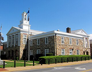
Woodstock is a town and the county seat of Shenandoah County, Virginia, United States. It has a population of 5,212 according to the 2017 census. Woodstock comprises 3.2 square miles of incorporated area of the town, and is located along the "Seven Bends" of the north fork of the Shenandoah River. While some tourism references list Woodstock as the fourth oldest town in Virginia, the area was sparsely settled and perhaps platted in 1752 or shortly thereafter, but the town was actually established by charter in 1761. While there are a number of Virginia towns closer to the eastern seaboard that claim earlier founding dates, Woodstock was one of the first towns west of the Blue Ridge.

The Eastern Panhandle is the eastern of the two panhandles in the U.S. state of West Virginia; the other is the Northern Panhandle. It is a small stretch of territory in the northeast of the state, bordering Maryland and Virginia. Some sources and regional associations only identify the Eastern Panhandle as being composed of Morgan, Berkeley, and Jefferson counties. Berkeley and Jefferson counties are geographically located in the Shenandoah Valley. West Virginia is the only U.S. state with two panhandles.

The Valley campaigns of 1864 began as operations initiated by Union Lieutenant General Ulysses S. Grant and resulting battles that took place in the Shenandoah Valley of Virginia during the American Civil War from May to October 1864. Some military historians divide this period into three separate campaigns. This article considers them together, as the campaigns interacted and built upon one another.

Shenandoah Junction is a census-designated place (CDP) in Jefferson County in the U.S. state of West Virginia's Eastern Panhandle. As of the 2010 census, Shenandoah Junction had a population of 703. It is located between Kearneysville, WV and Charles Town, WV off WV 9. Shenandoah Junction is home to Jefferson High School and West Virginia's oldest surviving wood-frame structure, the Peter Burr House, built around 1751. The land where Shenandoah Junction was built was part of the 392 acres (1.59 km2) granted by Lord Fairfax to Lewis Neil. The town was originally called Neil's, but the name was changed to Shenandoah Junction in 1881.
Shannondale is a census-designated place (CDP) in Jefferson County, West Virginia, United States. As of the 2010 census, its population was 3,358.

Great North Mountain is a 50-mile (80 km) long mountain ridge within the Ridge-and-valley Appalachians in the U.S. states of Virginia and West Virginia. The ridge is located west of the Shenandoah Valley and Massanutten Mountain in Virginia, and east of the Allegheny Mountains and Cacapon River in West Virginia.

State Route 263 is a primary state highway in the U.S. state of Virginia. Known as Orkney Grade, the state highway runs 12.63 miles (20.33 km) from SR 659 in Orkney Springs east to U.S. Route 11 in Mount Jackson. SR 263 connects Mount Jackson with a resort area in the mountains of southwestern Shenandoah County.

Orkney Springs is a CDP in western Shenandoah County, Virginia, United States. The reason for the name "Orkney" is unknown, but believed to be tied to either the Orkney Islands off the coast of Scotland or to the Earl of Orkney, since one of the earliest European landowners was Dr. John McDonald, a Scottish physician. The "Springs" part of the name comes from the numerous underground mineral springs in the area. Major Peter Higgins laid out the town in 1808, with a common area surrounded by lots; later archeological research found relics of prior Native American use of the site.

Holy Cross Abbey is a monastery of the Catholic Order of Cistercians of the Strict Observance (OCSO), popularly known as the Trappists. The monastery is located near Berryville in the Shenandoah Valley of Virginia, United States.


