Morning Sun, Iowa

Last updated

Morning Sun, Iowa
Morning Sun former church.jpg
A former church on the city's southeastern side
Louisa County Iowa Incorporated and Unincorporated areas Morning Sun Highlighted.svg
Location of Morning Sun, Iowa
Coordinates: 41°5′43″N91°15′13″W / 41.09528°N 91.25361°W / 41.09528; -91.25361
Country Flag of the United States (23px).png  United States
State Flag of Iowa.svg  Iowa
County Louisa
Township Morning Sun Township
Area
[1]
  Total0.78 sq mi (2.01 km2)
  Land0.78 sq mi (2.01 km2)
  Water0.00 sq mi (0.00 km2)
Elevation
[2]
750 ft (230 m)
Population
 (2020)
  Total752
  Density967.82/sq mi (373.63/km2)
Time zone UTC-6 (Central (CST))
  Summer (DST) UTC-5 (CDT)
ZIP code
52640
Area code 319
FIPS code 19-54120
GNIS feature ID0459240 [2]

Morning Sun is a city in Morning Sun Township, Louisa County, Iowa, United States. The population was 752 at the time of the 2020 census. [3] It is part of the Muscatine Micropolitan Statistical Area.

Contents

History

Morning Sun was laid out in 1851 by Cicero Hamilton. [4]

Geography

Morning Sun is located on the north side of Iowa Highway 78 approximately 1.5 miles north of the Louisa-Des Moines county line. Wapello is about six miles north. [5]

According to the United States Census Bureau, the city has a total area of 0.80 square miles (2.07 km2), all land. [6]

Demographics

Historical populations
YearPop.±%
1860 226    
1870 314+38.9%
1880 812+158.6%
1890 881+8.5%
1900 948+7.6%
1910 897−5.4%
1920 751−16.3%
1930 856+14.0%
1940 861+0.6%
1950 939+9.1%
1960 875−6.8%
1970 906+3.5%
1980 959+5.8%
1990 841−12.3%
2000 872+3.7%
2010 836−4.1%
2020 752−10.0%
Source: "U.S. Census website". United States Census Bureau . Retrieved March 29, 2020. and Iowa Data Center
Source:
U.S. Decennial Census [7] [3]

2010 census

As of the census [8] of 2010, there were 836 people, 314 households, and 220 families living in the city. The population density was 1,045.0 inhabitants per square mile (403.5/km2). There were 360 housing units at an average density of 450.0 per square mile (173.7/km2). The racial makeup of the city was 98.3% White, 0.5% African American, 0.1% Native American, 0.1% from other races, and 1.0% from two or more races. Hispanic or Latino of any race were 1.6% of the population.

There were 314 households, of which 32.2% had children under the age of 18 living with them, 54.1% were married couples living together, 11.5% had a female householder with no husband present, 4.5% had a male householder with no wife present, and 29.9% were non-families. 26.1% of all households were made up of individuals, and 15.3% had someone living alone who was 65 years of age or older. The average household size was 2.54 and the average family size was 3.04.

The median age in the city was 39.8 years. 25.7% of residents were under the age of 18; 5.5% were between the ages of 18 and 24; 24.1% were from 25 to 44; 25.7% were from 45 to 64; and 18.9% were 65 years of age or older. The gender makeup of the city was 49.5% male and 50.5% female.

2000 census

As of the census [9] of 2000, there were 872 people, 338 households, and 239 families living in the city. The population density was 1,119.5 inhabitants per square mile (432.2/km2). There were 366 housing units at an average density of 469.9 per square mile (181.4/km2). The racial makeup of the city was 97.36% White, 0.11% African American, 0.46% Native American, 0.46% Asian, 1.38% from other races, and 0.23% from two or more races. Hispanic or Latino of any race were 3.78% of the population.

There were 338 households, out of which 31.1% had children under the age of 18 living with them, 58.3% were married couples living together, 10.1% had a female householder with no husband present, and 29.0% were non-families. 25.4% of all households were made up of individuals, and 15.7% had someone living alone who was 65 years of age or older. The average household size was 2.46 and the average family size was 2.90.

In the city, the population was spread out, with 25.6% under the age of 18, 6.5% from 18 to 24, 28.1% from 25 to 44, 19.7% from 45 to 64, and 20.1% who were 65 years of age or older. The median age was 38 years. For every 100 females, there were 87.9 males. For every 100 females age 18 and over, there were 84.9 males.

The median income for a household in the city was $37,727, and the median income for a family was $43,173. Males had a median income of $32,107 versus $20,313 for females. The per capita income for the city was $19,041. About 8.3% of families and 12.2% of the population were below the poverty line, including 18.4% of those under age 18 and 9.3% of those age 65 or over.

Notable people

Related Research Articles

<span class="mw-page-title-main">Louisa County, Iowa</span> County in Iowa, United States

Louisa County is a county located in the U.S. state of Iowa. As of the 2020 census, the population was 10,837. The county seat is Wapello.

<span class="mw-page-title-main">New Boston, Illinois</span> City in Illinois, United States

New Boston is a city in Mercer County, Illinois, United States on the Mississippi River. The population was 613 at the 2020 census, down from 683 in 2010.

<span class="mw-page-title-main">Sheldahl, Iowa</span> City in Iowa, United States

Sheldahl is a city in Polk, Boone, and Story counties in the U.S. state of Iowa. The population was 297 at the time of the 2020 census.

<span class="mw-page-title-main">Williams, Iowa</span> City in Iowa, United States

Williams is a city in Hamilton County, Iowa, United States. The population was 307 at the time of the 2020 census. Williams is a regional center of wind power generation.

<span class="mw-page-title-main">Mondamin, Iowa</span> City in Iowa, United States

Mondamin is a city in Harrison County, Iowa, United States. The population was 339 at the time of the 2020 census.

<span class="mw-page-title-main">Oxford, Iowa</span> City in Iowa, United States

Oxford is a city in Johnson County, Iowa, United States. It is part of the Iowa City, Iowa Metropolitan Statistical Area. The population was 722 at the time of the 2020 census.

<span class="mw-page-title-main">Walker, Iowa</span> City in Iowa, United States

Walker is a city in Linn County, Iowa. The population was 688 at the 2020 census. It is part of the Cedar Rapids, Iowa metropolitan area.

<span class="mw-page-title-main">Columbus City, Iowa</span> City in Iowa, United States

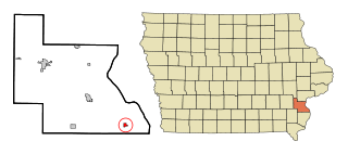
Columbus City is a city in western Louisa County, Iowa, United States. The population was 392 at the 2020 census. It is part of the Muscatine Micropolitan Statistical Area.

<span class="mw-page-title-main">Cotter, Iowa</span> City in Iowa, United States

Cotter is a city in western Louisa County, Iowa, United States. The population was 39 at the 2020 census. It is part of the Muscatine Micropolitan Statistical Area.

<span class="mw-page-title-main">Fredonia, Iowa</span> City in Iowa, United States

Fredonia is a city in Louisa County, Iowa, United States. The population was 222 at the time of the 2020 census. It is part of the Muscatine Micropolitan Statistical Area.

<span class="mw-page-title-main">Grandview, Iowa</span> City in Iowa, United States

Grandview is a city in Louisa County, Iowa, United States. The population was 437 at the time of the 2020 census. It is part of the Muscatine Micropolitan Statistical Area.

<span class="mw-page-title-main">Letts, Iowa</span> City in Iowa, United States

Letts is a city in northern Louisa County, Iowa, United States, established in 1855. The population was 363 at the time of the 2020 census. It is part of the Muscatine Micropolitan Statistical Area. The name is taken from that of local benefactor, Nehemiah Madison Letts.

<span class="mw-page-title-main">Oakville, Iowa</span> City in Iowa, United States

Oakville is a city in southeastern Louisa County, Iowa, United States. The population was 200 at the time of the 2020 census. It is part of the Muscatine Micropolitan Statistical Area.

<span class="mw-page-title-main">Wapello, Iowa</span> City in Iowa, United States

Wapello is a city in and the county seat of Louisa County, Iowa, United States. The population was 2,084 at the time of the 2020 census.

<span class="mw-page-title-main">Fruitland, Iowa</span> City in Iowa, United States

Fruitland is a city in Muscatine County, Iowa, United States. The population was 963 at the time of the 2020 census. It is part of the Muscatine Micropolitan Statistical Area.

<span class="mw-page-title-main">Elkhart, Iowa</span> City in Iowa, United States

Elkhart is a city in Polk County, Iowa, United States. The population was 882 at the time of the 2020 census. It is part of the Des Moines–West Des Moines Metropolitan Statistical Area.

<span class="mw-page-title-main">Runnells, Iowa</span> City in Iowa, United States

Runnells is a city in the southeastern corner of Polk County, Iowa, United States. The population was 457 at the time of the 2020 census. It is part of the Des Moines–West Des Moines Metropolitan Statistical Area. Runnells has its own Post Office, located at 112 Brown Street.

<span class="mw-page-title-main">Macedonia, Iowa</span> City in Iowa, United States

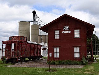
Macedonia is a city in Pottawattamie County, Iowa, United States. The population was 267 at the time of the 2020 census.

<span class="mw-page-title-main">North English, Iowa</span> City in Iowa, United States

North English is a city located mainly in Iowa county with a small portion in Keokuk county in the U.S. state of Iowa. The population was 1,065 at the time of the 2020 census. It is named for the English River.

<span class="mw-page-title-main">Bevington, Iowa</span> City in Iowa, United States

Bevington is a city in Madison and Warren Counties in the U.S. state of Iowa. The population was 57 at the 2020 census. It is part of the Des Moines–West Des Moines Metropolitan Statistical Area.

References

  1. "2020 U.S. Gazetteer Files". United States Census Bureau. Retrieved March 16, 2022.
  2. 1 2 U.S. Geological Survey Geographic Names Information System: Morning Sun, Iowa
  3. 1 2 "2020 Census State Redistricting Data". census.gov. United states Census Bureau. Retrieved August 12, 2021.
  4. Springer, Arthur (1912). History of Louisa County, Iowa, from Its Earliest Settlement to 1912, Volume 1. S. J. Clarke Publishing Company. p. 309.
  5. Iowa Atlas & Gazetteer, DeLorme, 7th Edition, 2021 pp. 52 and 62 ISBN   1946494003
  6. "US Gazetteer files 2010". United States Census Bureau. Archived from the original on January 25, 2012. Retrieved May 11, 2012.
  7. "Census of Population and Housing". Census.gov. Retrieved June 4, 2015.
  8. "U.S. Census website". United States Census Bureau . Retrieved May 11, 2012.
  9. "U.S. Census website". United States Census Bureau . Retrieved January 31, 2008.