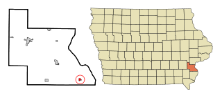
Louisa County is a county located in the U.S. state of Iowa. As of the 2020 census, the population was 10,837. The county seat is Wapello.

Henry County is a county located in the U.S. state of Iowa. As of the 2020 census, the population was 20,482. The county seat is Mount Pleasant. The county was named for General Henry Dodge, governor of Wisconsin Territory.
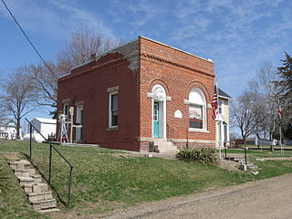
Cotter is a city in western Louisa County, Iowa, United States. The population was 39 at the 2020 census. It is part of the Muscatine Micropolitan Statistical Area.
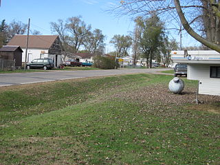
Fredonia is a city in Louisa County, Iowa, United States. The population was 222 at the time of the 2020 census. It is part of the Muscatine Micropolitan Statistical Area.

Grandview is a city in Louisa County, Iowa, United States. The population was 437 at the time of the 2020 census. It is part of the Muscatine Micropolitan Statistical Area.

Morning Sun is a city in Morning Sun Township, Louisa County, Iowa, United States. The population was 752 at the time of the 2020 census. It is part of the Muscatine Micropolitan Statistical Area.
Oakville is a city in southeastern Louisa County, Iowa, United States. The population was 200 at the time of the 2020 census. It is part of the Muscatine Micropolitan Statistical Area.

Wapello is a city in and the county seat of Louisa County, Iowa, United States. The population was 2,084 at the time of the 2020 census.

This is a list of properties and historic districts in Iowa that are listed on the National Register of Historic Places. There are listings in all of Iowa's 99 counties, adding up to over 2,300 total.

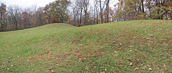
The Toolesboro Mound Group, a National Historic Landmark, is a group of Havana Hopewell culture earthworks on the north bank of the Iowa River near its discharge into the Mississippi. The mounds are owned and displayed to the public by the State Historical Society of Iowa. The mound group is located east of Wapello, Iowa, near the unincorporated community of Toolesboro.

The State Historical Society of Iowa (SHSI), a division of the Iowa Department of Cultural Affairs, serves as the official historical repository for the State of Iowa and also provides grants, public education, and outreach about Iowa history and archaeology. The SHSI maintains a museum, library, archives, and research center in Des Moines and a research library in Iowa City, as well as several historic sites in Iowa. It was founded in 1857 in Iowa City, where it was first affiliated with the University of Iowa. As the organization grew in size and collections, it became a separate state agency headquartered near the Iowa Capitol in Des Moines.

The following outline is provided as an overview of and topical guide to the U.S. state of Iowa.
Port Allen is an unincorporated community in Iowa, United States, located along the Louisa-Muscatine County line on Iowa Highway 70. It was formerly a thriving town, but today is merely a housing sub-division.
The Louisa County Courthouse in Wapello, Iowa, United States, was built in 1928. It was listed on the National Register of Historic Places in 1981 as a part of the County Courthouses in Iowa Thematic Resource. The courthouse is the fourth building the county has used for court functions and county administration.
Port Louisa Township is a township in Louisa County, Iowa.

Iowa Highway 99 (Iowa 99) was a state highway in southeastern Iowa. It began in downtown Burlington and generally followed the course of the Mississippi River north to Wapello. Most of the route was a part of the Great River Road. The highway was designated in 1931 and its course remained unchanged until it was removed from the primary highway system in 2003. It was replaced by County Road X99, though around Burlington, it is sometimes referred to as County Road 99.
Florence-Council On The Iowa Site is a former town site and Native American village site located near Oakville, Iowa, United States in Louisa County. The site has been listed on the National Register of Historic Places since 1978.
Bard was an unincorporated community in Louisa County, in the U.S. state of Iowa.