Mortlake, Connecticut

Last updated

Mortlake was a historical place name in what is now Brooklyn, Connecticut. [1]

History

On October 19, 1687, the Connecticut Colonial General Court granted Captain William Blackwell a patent for a separate township laid out south of Mashamoquet Brook, six miles east to west and seven miles north to south, to be called Mortlake. Captain Blackwell chose that name to honor Mortlake in Surrey, England (now part of greater London).

Geographically, the northbound followed Mashamoquet Brook, the eastbound followed the Quinebaug. The western boundary was approximately half mile west of and parallel to today's Connecticut State Route 169, while the southern boundary laid approximately half mile north of today's U.S. Route 6 – looking at a map, it roughly aligned with Herrick Road and the part of Brown Road that runs more or less straight east–west.

This patent was in the form of a Manor, a form of tenure restricted to certain Proprietary colonies, a large estate with hereditary rights granted by royal charter, – a legal anomaly in Connecticut, where it was outside of the power and authority of any Town. Jurisdiction in Mortlake did not rest in an elected town government, but as property right that could be bought and sold. Falling outside the legal framework that Connecticut organized Towns, Mortlake's residents found themselves without responsibilities, but also without normal rights (such as to levy taxes to pay for roads and general welfare of its inhabitants). Indeed, once Windham County was established the very first case heard in its courts was a lawsuit by the Town of Norwich to force Mortlake to pay for the care of “the poor, witless Peter Davison” who resided originally in Mortlake. Massachusetts Governor Johnathan Belcher, who had purchased Mortlake from Captain Blackwell, was successfully defended by his attorney with the argument that Mortlake as a Manor did not have the same responsibilities to the poor as a Town would.

The Town of Pomfret bordered Mortlake to the North, West, and after Pomfret was expanded southward taking a portion of Canterbury, on the South as well. This southernmost part of Pomfret being the area today known as Brooklyn Center.

In 1731, an ecclesiastical society was formed to establish a Congregational Church for the benefit of the residents of the area – consisting of the southern half of Mortlake (the present Brooklyn / Pomfret town line), the southernmost parts of Pomfret, and the northern section of Canterbury.

It would take four years, but in 1735 the society was formally named the odd construct, “The Society taken out of Pomfret, Canterbury, and Mortlake.” The area was referred to as Mortlake Parish, with the church referred to as the Second Church of Pomfret.

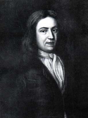
In 1739, Governor Belcher sold portions of Mortlake to Israel Putnam and John Pope of Salem, Massachusetts. Putnam would settle in Mortlake, and later buy out Pope. The remaining portions of Mortlake were sold to Godfrey Malbone of Newport, Rhode Island by Governor Belcher the following year.

The lack of town status continued to be a problem – residents of the southern village of Pomfret had to cross for some seven miles through Mortlake before re-entering Pomfret again. Further, at the time Town taxes were levied to support the Church – but the portions of Mortlake Parish within Mortlake Manor laid outside of either Pomfret or Canterbury, and thus could not be taxed to support the Church its residents where expected to attend.

Finally in May 1752, the General Court decided “that this tract of Mortlake shall be accounted, taken, and doomed to belong to Pomfret.” At the same time, they also replaced the lengthy name of the ecclesiastical society with the much simpler, “Society of Brooklyn” known as Brooklyn Parish.

In 1775 Israel Putnam, who held a commission from the Colony of Connecticut as a Major General, was plowing a field in Brooklyn Center (near where the library is today) when word reached him of the Battle of Lexington and Concord. Leaving his plow in the field, he rode a relay of horses to reach Boston in only 18 hours, taking command of the rebel forces, and at Breed's Hill uttering the famous, “Don't shoot until you see the whites of their eyes!”

Brooklyn Parish in 1786 would be set off from Pomfret and Canterbury to become a town in its own right.

In the 1920s and 30s, Edith Kermit Carow, wife of Theodore Roosevelt, operated an old family property as Mortlake House – a country inn for vacationing city visitors. Mrs. Roosevelt was a descendant of the Tyler family, and the Tylers where related by marriage to the Putnams.

Mortlake House was demolished in the late 1960s. Today, the Post Office stands on that spot, with a large equestrian statue of General Putnam adjacent to it, and the Daniel Tyler Law Office, which serves as the small museum of the Brooklyn Historical Society, at the rear of the property. The Tyler family continues to maintain the family homestead, Putnam Elms, on Church Street in Brooklyn as a historical site that is occasionally open to the general public.

Mortlake Fire Company Mortlake Fire Company, Brooklyn CT.jpg
Mortlake Fire Company

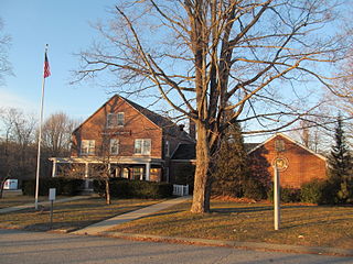
In 1927 the citizens of Brooklyn Center established a volunteer fire department, and as a nod to both the history of the area being known as Mortlake and to Mrs. Roosevelt and her establishment named the organization, “The Mortlake Fire Company of Brooklyn, Connecticut, Inc.” – which carries that name until this day.

Related Research Articles

<span class="mw-page-title-main">Dutchess County, New York</span> County in New York, United States

Dutchess County is a county in the U.S. state of New York. As of the 2020 census, the population was 295,911. The county seat is the city of Poughkeepsie. The county was created in 1683, one of New York's first twelve counties, and later organized in 1713. The county is part of the Hudson Valley region of the state.

<span class="mw-page-title-main">Israel Putnam</span> American military officer and landowner (1718–1790)

Israel Putnam, popularly known as "Old Put", was an American military officer and landowner who fought with distinction at the Battle of Bunker Hill during the American Revolutionary War (1775–1783). He also served as an officer with Rogers' Rangers during the French and Indian War (1754–1763), when he was captured by Mohawk warriors. He was saved from the ritual burning given to enemies by the intervention of French officer Molang, with whom the Mohawks were allied. Putnam's courage and fighting spirit became known far beyond his home of Connecticut's borders through the circulation of folk legends in the American colonies and states celebrating his exploits.

<span class="mw-page-title-main">Windham County, Connecticut</span> County in Connecticut, United States

Windham County is one of the eight historical counties in the U.S. state of Connecticut, located in its northeastern corner. As of the 2020 census, the population was 116,418, making it the least populous county in Connecticut. It forms the core of the region known as the Quiet Corner. Windham County is included in the Worcester, MA-CT Metropolitan Statistical Area, which is also included in the Boston-Worcester-Providence, MA-RI-NH-CT Combined Statistical Area. The entire county is within the Quinebaug and Shetucket Rivers Valley National Heritage Corridor, as designated by the National Park Service.

<span class="mw-page-title-main">Mortlake</span> Human settlement in England

Mortlake is a suburban district of the London Borough of Richmond upon Thames on the south bank of the River Thames between Kew and Barnes. Historically it was part of Surrey and until 1965 was in the Municipal Borough of Barnes. For many centuries it had village status and extended far to the south, to include East Sheen and part of what is now Richmond Park. Its Stuart and Georgian history was economically one of malting, brewing, farming, watermen and the Mortlake Tapestry Works (1617–1704), Britain's most important producer. A London landmark, the former Mortlake Brewery or Stag Brewery, is on the edge of Mortlake.

<span class="mw-page-title-main">Brooklyn, Connecticut</span> Town in Connecticut, United States

Brooklyn is a town in Windham County, Connecticut, United States. The town is part of the Northeastern Connecticut Planning Region. The population was 8,450 at the 2020 census. The town center village is listed by the U.S. Census Bureau as a census-designated place. The district of East Brooklyn is listed as a separate census-designated place.

<span class="mw-page-title-main">Canterbury, Connecticut</span> Town in Connecticut, United States

Canterbury is a town in Windham County, Connecticut, United States. The town is part of the Northeastern Connecticut Planning Region. The population was 5,045 at the 2020 census.

<span class="mw-page-title-main">Hampton, Connecticut</span> Town in Connecticut, United States

Hampton is a town in Windham County, Connecticut, United States. The town is part of the Northeastern Connecticut Planning Region. The population was 1,728 at the 2020 census.

<span class="mw-page-title-main">Pomfret, Connecticut</span> Town in Connecticut, United States

Pomfret is a town located in Windham County, Connecticut with a population of 4,266 according to the 2020 United States Census. The town is part of the Northeastern Connecticut Planning Region. The town was incorporated in 1713 and was named after Pontefract in West Yorkshire, England. The land on which Pomfret stands today was purchased from Native Americans in 1686 in a deal known as the "Mashmuket Purchase" or "Mashamoquet Purchase".

<span class="mw-page-title-main">Putnam, Connecticut</span> Town in Connecticut, United States

Putnam is a town in Windham County, Connecticut, United States. The town is part of the Northeastern Connecticut Planning Region. The population was 10,214 at the 2020 census.

<span class="mw-page-title-main">Pelham, New York</span> Town in New York, United States

Pelham is a suburban town in Westchester County, approximately 10 miles northeast of Midtown Manhattan. As of the 2020 census, it had a population of 13,078, an increase from the 2010 census. Historically, Pelham was composed of five villages and became known as "the Pelhams". Pelham currently contains two independently incorporated villages: the Villages of Pelham and Pelham Manor.

<span class="mw-page-title-main">Route 169 (Connecticut–Massachusetts)</span> Highway in Connecticut and Massachusetts

Route 169 is a 47.36-mile-long (76.22 km) state highway in the U.S. states of Connecticut and Massachusetts. It begins in the city of Norwich, Connecticut, and runs 38 miles (61 km) through Northeastern Connecticut, continuing across the state line into Southbridge, Massachusetts. The route ends in Charlton after another nine miles (14 km). A portion of the route in the town center of Pomfret is on the National Register of Historic Places as Pomfret Street Historic District, and 32.10 miles (51.66 km) of the road is designated as the Connecticut State Route 169 National Scenic Byway.

<span class="mw-page-title-main">Quinebaug River</span> River in Massachusetts, United States

The Quinebaug River is a river in south-central Massachusetts and eastern Connecticut, with watershed extending into western Rhode Island. The name "Quinebaug" comes from the southern New England Native American term, spelled variously Qunnubbâgge, Quinibauge, etc., meaning "long pond", from qunni-, "long", and -paug, "pond". The river is one of the namesake rivers in the Quinebaug and Shetucket Rivers Valley National Heritage Corridor.

<span class="mw-page-title-main">Quiet Corner</span> Rural region in Connecticut, US

Northeastern Connecticut, better known as the Quiet Corner, is a historic region of the state of Connecticut, located in the northeastern corner of the state. No official definition exists; the term is generally associated with Windham County, but also sometimes incorporates eastern sections of Tolland County and the northern portion of New London County.

<span class="mw-page-title-main">Unitarian Meetinghouse</span> Historic meetinghouse in Connecticut, United States

The Unitarian Meetinghouse is a historic church at the junction of Connecticut Routes 169 and 6 in the village center of Brooklyn, Connecticut. Built in 1771, it is one of a small number of pre-Revolutionary church buildings in the state, and distinctive for having a sufficiently complete documentary record to support a complete restoration. It retains a configuration distinctive of that period, with its main entrance on the long side of the building, and the pulpit opposite. The bell tower with steeple is located at one of the short ends, suggestive of the 19th century change to place the entrance there as well. The building was listed on the National Register of Historic Places in 1972.

<span class="mw-page-title-main">Brooklyn Green Historic District</span> Historic district in Connecticut, United States

Brooklyn Green Historic District is a historic district on Route 169, Route 205, U.S. Route 6, Wolf Den, Brown, Prince Hill, and Hyde Roads in the town of Brooklyn, Connecticut. The district is notable for its Greek Revival, Colonial, and Federal architecture. It was added to the National Register of Historic Places in 1982.

<span class="mw-page-title-main">Bush Hill Historic District</span> Historic district in Connecticut, United States

The Bush Hill Historic District encompasses a historic rural landscape in central northern Brooklyn, Connecticut. It extends along parts of Bush Hill Road, Connecticut Route 169, and Wolf Den Road. The area has a remarkable concentration of farmhouses and agricultural outbuildings dating to the early 19th century or earlier. The district was listed on the National Register of Historic Places in 1987.

<span class="mw-page-title-main">Putnam Farm</span> United States historic place

The Putnam Farm is a historic farm on Spaulding Road in Brooklyn, Connecticut. The property, now just 9 acres (3.6 ha) of agricultural land with a house on it, was the centerpiece of a vast landholding in the mid-18th century by Major General Israel Putnam, a major colonial-era military figure who saw action in both the French and Indian War and in the American Revolutionary War. The property was listed on the National Register of Historic Places in 1982.

<span class="mw-page-title-main">Mashamoquet Brook State Park</span> State park in Windham County, Connecticut

Mashamoquet Brook State Park is a public recreation area in the town of Pomfret, Connecticut. Notable features of the state park include the Wolf Den national historic site, the Brayton Grist Mill, and the Table Rock and Indian Chair natural stone formations. The state park offers facilities for camping, swimming, fishing, and picnicking. It is managed by the Connecticut Department of Energy and Environmental Protection.

<span class="mw-page-title-main">Adolphus Philipse</span> Landowner

Adolphus Philipse (1665–1750) was a wealthy landowner of Dutch descent in the Province of New York. In 1697 he purchased a large tract of land along the east bank of the Hudson River stretching all the way to the east to the Connecticut border. Then known as the "Highland Patent" it became in time referred to as the Philipse Patent. After his death the Patent was inherited by his nephew, Frederick Philipse II, his only heir-at-law, who became the second Lord of the Manor of Philipsborough in Westchester County.

The Northeastern Connecticut Transit District (NECTD) is an agency providing multiple forms of public transportation in northeastern Connecticut. Six fixed routes (with deviation on request) provide week-round service to the towns of Brooklyn, Killingly, Plainfield, Putnam, and Thompson. Using fixed route service connections to WRTD can be made in Killingly and to SEAT in Plainfield respectively. With advance reservation NECTD also offers dial-a-ride service to the general public and door-to-door to select elderly and disabled persons. Dial-a-ride and door-to-door service is available to all towns served by NECTD's fixed routes as well as to Canterbury, Eastford, Hampton, Pomfret, Union, and Woodstock. Following a pilot program which began in 1977, NECTD was founded in October 1979, with its first service beginning in August 1980.

References

  1. "Town of Brooklyn". Geographic Names Information System . United States Geological Survey, United States Department of the Interior.

41°47′14″N71°56′59″W / 41.78722°N 71.94972°W / 41.78722; -71.94972