Mount Fairchild

Last updated
Mount Fairchild
Mt. Fairchild.jpg
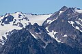
Mount Fairchild from Hurricane Ridge
Highest point
Elevation 6,900 ft (2,100 m) [1]
Prominence 450 ft (140 m) [1]
Parent peak Mount Carrie (6,995 ft) [2]
Isolation 0.85 mi (1.37 km) [2]
Coordinates 47°54′01″N123°38′00″W / 47.900141°N 123.633367°W / 47.900141; -123.633367 [1]
Geography
USA Washington relief location map.jpg
Red triangle with thick white border.svg
Mount Fairchild
Location of Mount Fairchild in Washington
Usa edcp relief location map.png
Red triangle with thick white border.svg
Mount Fairchild
Mount Fairchild (the United States)
Location Olympic National Park
Clallam County, Washington, US
Parent range Olympic Mountains
Topo map USGS Mount Carrie
Geology
Age of rock Eocene
Climbing
First ascent 1963
Easiest route class 3 scrambling [2] [3]

Mount Fairchild, also known as Mount William Fairchild, is a 6,900-foot (2,100-metre) glaciated mountain summit located within Olympic National Park in Clallam County of Washington state. [4] Mt. Fairchild is the second-highest peak in the Bailey Range, which is a subrange of the Olympic Mountains. Its nearest higher neighbor is Mount Carrie, 0.84 mi (1.35 km) to the southwest, and Ruth Peak is set 0.92 mi (1.48 km) to the south. [1] In clear weather, the mountain can be seen from the visitor center at Hurricane Ridge. Precipitation runoff from the mountain drains into tributaries of the Elwha River.

Contents

History

Fairchild's airplane on Mt. Olympus Fairchild airplane -- Snow Dome.png
Fairchild's airplane on Mt. Olympus

Mount Fairchild is situated at the head of Fairchild Creek, which originates from the Fairchild Glacier, and each are named for pilot William R. Fairchild (1926–1969), who flew hundreds of photographic flights to support scientific studies of glaciers in the Olympic Mountains for the U. S. Geological Survey and U.S. National Park Service, as well as thousands of other glaciers in Western North America. [4] [5] Fairchild's method of taking off from the nearby Blue Glacier became known as the "Fairchild sleigh ride", and was seen in a climactic scene in a two-part show in the Lassie TV series. [6] Fairchild was one of ten who died when the air taxi service he created crashed on February 5, 1969, immediately after take-off from Port Angeles, en route to Seattle. [7] This mountain's toponym was officially adopted in 1975 by the U.S. Board on Geographic Names. [4] The William R. Fairchild International Airport in nearby Port Angeles is also named after him.

The first ascent of this peak was made in 1963 by Denny Pruitt, Dan Baker, Jack Christiansen, and Roy Etten. [8]

Climate

Based on the Köppen climate classification, Mount Fairchild is located in the marine west coast climate zone of western North America. [9] This climate supports the Fairchild and Carrie Glaciers on its slopes. Most weather fronts originate in the Pacific Ocean, and travel northeast toward the Olympic Mountains. As fronts approach, they are forced upward by the peaks of the Olympic Range, causing them to drop their moisture in the form of rain or snowfall (Orographic lift). As a result, the Olympics experience high precipitation, especially during the winter months. During winter months, weather is usually cloudy, but, due to high pressure systems over the Pacific Ocean that intensify during summer months, there is often little or no cloud cover during the summer. In terms of favorable weather, the best months for viewing and climbing are July through September.

Geology

The Olympic Mountains are composed of obducted clastic wedge material and oceanic crust, primarily Eocene sandstone, turbidite, and basaltic oceanic crust. [10] The mountains were sculpted during the Pleistocene era by erosion and glaciers advancing and retreating multiple times.

See also

Related Research Articles

<span class="mw-page-title-main">Mount Carrie</span> Mountain in Washington (state), United States

Mount Carrie is a 6,995-foot (2,132-metre) mountain summit located within Olympic National Park in Clallam County of Washington state. Mt. Carrie is the highest point in the Bailey Range which is a subrange of the Olympic Mountains. With a good eye and clear weather, the mountain can be seen from the visitor center at Hurricane Ridge. Its nearest higher peak is Mount Mathias (7,156 ft) which is an outlier of Mount Olympus, 6.24 mi (10.04 km) to the south. Due to heavy winter snowfalls, Mount Carrie supports the Carrie Glacier in its northeast cirque, and Fairchild Glacier on the east slope. Precipitation runoff from the mountain drains into tributaries of the Elwha River and Hoh River. There is a scrambling route via the High Divide Trail and Cat Walk.

<span class="mw-page-title-main">Mount Tom (Washington)</span> Mountain in Washington (state), United States

Mount Tom is a remote 7,076-foot (2,157-metre) mountain summit located within Olympic National Park in Jefferson County of Washington state. Its nearest higher neighbor is Mount Olympus, 1.76 mi (2.83 km) to the east. Due to heavy winter snowfalls, Mount Tom supports the massive White Glacier on its northeast slope, despite its modest elevation. This glacier is the westernmost glacier in the contiguous states, and the summit is the westernmost peak higher than 7000+ feet elevation. Precipitation runoff from the mountain drains into tributaries of the Hoh River.

<span class="mw-page-title-main">Sentinel Peak (Jefferson County, Washington)</span> Mountain in Washington (state), United States

Sentinel Peak is a 6,592-foot-high (2,009 m) mountain summit located in the Olympic Mountains, in Jefferson County of Washington state. Rising in the center of Olympic National Park, its nearest higher neighbor is Mount Fromme, 1.42 miles (2.29 km) to the northwest. Sentinels Sister is a lower 6,301-foot-high (1,921 m) companion summit situated 0.65 miles (1.05 km) to the southwest. The two peaks stand as sentinels above the Dosewalips Valley and Hayden Pass, and were possibly named by an early expedition of the Seattle Mountaineers. Precipitation runoff from the peak drains to Hood Canal via the Dosewallips River.

<span class="mw-page-title-main">Stephen Peak</span> Mountain in Washington (state), United States

Stephen Peak is a 6,418-foot (1,956-metre) mountain summit located within Olympic National Park in Jefferson County of Washington state. Stephen Peak is the fifth-highest peak in the Bailey Range, which is a subrange of the Olympic Mountains. In clear weather, the mountain can be seen from the visitor center at Hurricane Ridge, appearing to the left of Mount Olympus. Mount Ferry is set 2.26 mi (3.64 km) to the southeast, and Stephen's nearest higher neighbor is Ruth Peak which is an outlier of Mount Carrie, 2.1 mi (3.4 km) to the northwest. Precipitation runoff from the mountain drains into tributaries of the Elwha River and Hoh River. The first ascent of this peak was made in 1961 by Kent Heathershaw, Doug Waali, and Robert Wood.

<span class="mw-page-title-main">Mount Fitzhenry</span> Mountain in Washington (state), United States

Mount Fitzhenry is a 6,050-foot (1,840-metre) mountain summit located within Olympic National Park in Clallam County of Washington state. Mt. Fitzhenry is in the Bailey Range, which is a subrange of the Olympic Mountains. The mountain can be seen from the visitor center at Hurricane Ridge in clear weather. Its nearest higher neighbor is Mount Fairchild, 1.57 mi (2.53 km) to the south. Precipitation runoff from the mountain drains into tributaries of the Elwha River. Mount Fitzhenry is situated at the head of Fitzhenry Creek, and both are named for Edward Allen Fitzhenry (1868–1937), Clallam County surveyor from 1892-1900. President Woodrow Wilson appointed Fitzhenry as Washington Surveyor General in 1913, and he later served as Deputy State Land Commissioner.

<span class="mw-page-title-main">Mount Ferry</span> Mountain in Washington (state), United States

Mount Ferry is a 6,195-foot (1,888-metre) mountain summit located within Olympic National Park in Jefferson County of Washington state. Mount Ferry is the eighth-highest peak in the Bailey Range, which is a subrange of the Olympic Mountains. In clear weather, the mountain can be seen from the visitor center at Hurricane Ridge. Its nearest higher neighbor is Mount Pulitzer, 0.6 mi (0.97 km) to the southwest. Stephen Peak is set 2.26 mi (3.64 km) to the northwest, and Mount Olympus is 7.2 mi (11.6 km) to the southwest. Precipitation runoff from the mountain drains into tributaries of the Elwha and Hoh Rivers.

<span class="mw-page-title-main">Mount Pulitzer (Washington)</span> Mountain in Washington (state), United States

Mount Pulitzer, also known as Snagtooth, is a 6,283-foot (1,915-metre) mountain summit located within Olympic National Park in Jefferson County of Washington state. Mount Pulitzer is the sixth-highest peak in the Bailey Range, which is a subrange of the Olympic Mountains. Its nearest neighbor is Mount Ferry, 0.58 mi (0.93 km) to the northeast, and its nearest higher neighbor is Stephen Peak, 2.58 mi (4.15 km) to the north. Mount Olympus is set 6.8 mi (10.9 km) to the southwest. In clear weather, the mountain can be seen from the visitor center at Hurricane Ridge. Precipitation runoff from the mountain drains into tributaries of the Elwha and Hoh Rivers. The first ascent of the summit was made in 1961 by Doug Waali, Bob Wood, and Kent Heathershaw via the east ridge.

<span class="mw-page-title-main">Ruth Peak</span> Mountain in Washington (state), United States

Ruth Peak is a 6,850+ ft glaciated mountain summit located within Olympic National Park in Clallam County of Washington state. Ruth Peak is the third-highest peak in the Bailey Range, which is a subrange of the Olympic Mountains. Its nearest higher neighbor is Mount Carrie, 0.91 mi (1.46 km) to the northwest, and Mount Fairchild is set 0.92 mi (1.48 km) to the north. In clear weather, the mountain can be seen from the visitor center at Hurricane Ridge. Precipitation runoff from the mountain drains into tributaries of the Hoh and Elwha Rivers. The first ascent of this peak was made in 1961 by Bert Brown, Roy Etten, and Victor Nelson.

<span class="mw-page-title-main">Sundial (Olympic Mountains)</span> Mountain in Washington (state), United States

Sundial is a 7,200+ ft mountain summit located within Olympic National Park, in Jefferson County of Washington state. Sundial is part of The Needles range, which is a subrange of the Olympic Mountains. Its nearest higher neighbor is Mount Clark, 0.27 mi (0.43 km) to the northwest, and Mount Johnson is set 0.45 mi (0.72 km) to the west. The climbing routes on Sundial start at class 3 scrambling via the East Face, and range up to class 5 via the South Side Face. The first ascent of the mountain was made in 1944 by Adel and William Degenhardt. The mountain is so named because the time of day can be approximated as an observer in Royal Basin watches the sun's rays make their way down the east face of this mountain in the morning. Precipitation runoff from the mountain drains into Royal Creek which is a tributary of the Dungeness River.

<span class="mw-page-title-main">Mount Claywood</span> Mountain in Washington (state), United States

Mount Claywood is a 6,836-foot (2,084-metre) mountain summit located within Olympic National Park in Jefferson County of Washington state. It is situated at the head of Lost River, and 15 mi (24 km) east of Mount Olympus. Its nearest higher neighbor is Mount Cameron, 2.4 mi (3.9 km) to the northeast. Other nearby peaks include Mt. Fromme, 0.58 mi (0.93 km) to the southeast, and Sentinel Peak, 2 mi (3.2 km) also to the southeast. Precipitation runoff from the mountain drains north and west into tributaries of the Elwha River, and east into Claywood Lake, thence Dosewallips River.

<span class="mw-page-title-main">Woden - The Valhallas</span> Mountain in Washington (state), United States

Woden is a 6,038-foot (1,840-metre) mountain summit located within Olympic National Park in Jefferson County of Washington state. Its nearest higher neighbor is Mount Tom, 3 mi (4.8 km) to the north-northwest, and Mount Olympus rises 3.8 mi (6.1 km) to the north-northeast. Woden is the highest point in The Valhallas, a sub-range south of Mount Olympus. Precipitation runoff from the mountain drains into tributaries of the South Fork Hoh River and Queets River. The Geri-Freki Glacier, which descends north from Woden. is the only glacier in The Valhallas.

<span class="mw-page-title-main">Athena (Olympic Mountains)</span> Mountain in Washington (state), United States

Athena is a 7,365-foot-elevation (2,245 meter) mountain summit located within Olympic National Park in Jefferson County of Washington state. Athena is situated at the head of the Hoh Glacier, and the Hubert Glacier lies below the west aspect. Its neighbors include Mount Olympus, 1.7 mi (2.7 km) to the northwest, and Aries 1.7 mi (2.7 km) to the northeast. Athena has subpeaks "Athena II" (7,259 ft), and "Athena's Owl" (7,000 ft). Precipitation runoff from the mountain drains into the Queets and Hoh Rivers, with Athena being the highest point within the Queets drainage basin.

<span class="mw-page-title-main">Unicorn Peak (Olympic Mountains)</span> Mountain in Washington (state), United States

Unicorn Peak is a 5,100-foot-elevation (1,600-meter) mountain summit located within Olympic National Park in Clallam County of Washington state. Unicorn Peak is situated seven miles southwest of Port Angeles and three miles north-northwest of the park's Hurricane Ridge visitor center, in Daniel J. Evans Wilderness. Precipitation runoff from the mountain drains west to the Elwha River via Little River and Griff Creek. Topographic relief is significant as the west aspect rises 4,800 feet above the Elwha valley in approximately three miles.

<span class="mw-page-title-main">Mount Seattle (Washington)</span> Mountain in Washington (state), United States

Mount Seattle is a 6,246-foot (1,904-metre) mountain summit deep within Olympic National Park in Jefferson County of Washington state. Part of the Olympic Mountains, Mount Seattle is situated 7.5 miles southeast of Mount Olympus, and set within the Quinault Rainforest and Daniel J. Evans Wilderness. The nearest higher neighbor is Mount Meany, 1.65 miles (2.66 km) to the north-northwest, and Mount Noyes rises one mile to the northwest. Precipitation runoff from the mountain drains north into headwaters of the Elwha River, and south into tributaries of the Quinault River. Topographic relief is significant as the northeast aspect of the peak rises over 3,800 feet (1,200 m) above the Elwha valley in approximately 1.5-mile. Low Divide forms the saddle between Mt. Seattle and Mount Christie.

<span class="mw-page-title-main">Mount Wilder</span> Mountain in Washington (state), United States

Mount Wilder is a 5,939-foot (1,810-metre) mountain summit located near the head of the Elwha Valley, deep within Olympic National Park in Jefferson County of Washington state. Part of the Olympic Mountains, Wilder represents the southernmost peak of the Bailey Range. It is situated 8.7 miles east-southeast of Mount Olympus, and is set within the Daniel J. Evans Wilderness. Neighbors include line parent Mount Dana, 2.3 miles (3.7 km) to the northeast, and Mount Seattle rises 3.7 miles to the southwest. The headwaters of the Goldie River form on the south slope of the mountain, and precipitation runoff from the mountain drains into Goldie River and other tributaries of the Elwha River. Topographic relief is significant as the south aspect of the peak rises nearly 3,800 feet (1,160 m) in less than two miles.

<span class="mw-page-title-main">Mount Delabarre</span> Mountain summit in Washington state

Mount Delabarre is a remote 6,024-foot (1,836-metre) mountain summit deep within Olympic National Park in Jefferson County of Washington state. Part of the Olympic Mountains, Mount Delabarre is 12.4 miles southeast of Mount Olympus, set within the Daniel J. Evans Wilderness. The nearest higher neighbor is line parent Mount Christie, 2.5 miles to the west-northwest. Precipitation runoff from the mountain drains north into headwaters of Delabarre Creek, which is a tributary of the Elwha River, and south into Rustler Creek, which is a tributary of the North Fork Quinault River. Topographic relief is significant as the southwest aspect of the peak rises 3,400 feet (1,036 m) above Rustler Creek in approximately one mile.

The Bailey Range is a mountain range located within Olympic National Park in Washington state.

<span class="mw-page-title-main">Ludden Peak</span> Mountain in Washington (state), United States

Ludden Peak is a 5,854-foot (1,784-metre) mountain summit located within Olympic National Park in Jefferson County of Washington state. Ludden Peak is part of the Bailey Range, which is a subrange of the Olympic Mountains, and is set within the Daniel J. Evans Wilderness. In clear weather, the mountain can be seen from the park's visitor center on Hurricane Ridge. The nearest higher neighbor is Mount Scott, one mile to the south-southeast, line parent Mount Ferry rises 1.6 mi (2.6 km) to the southwest, Dodger Point is 1.9 mi (3.1 km) to the northeast, and Stephen Peak is set 2.7 mi (4.3 km) to the northwest. Precipitation runoff from the mountain drains into tributaries of the Elwha River.

<span class="mw-page-title-main">Cat Peak</span> Mountain in Washington (state), United States

Cat Peak is a 5,940-foot (1,810-metre) mountain summit within Olympic National Park in Clallam County of Washington state.

<span class="mw-page-title-main">The Needles (Olympic Mountains)</span> Mountain in Washington (state), United States

The Needles is a mountain ridge located within Olympic National Park in Jefferson County of Washington state.

References

  1. 1 2 3 4 "Mount Fairchild". Peakbagger.com.
  2. 1 2 3 "Fairchild, Mount - 6,925' WA". listsofjohn.com. Retrieved 2020-06-13.
  3. climbersguideolympics.com Mount Fairchild
  4. 1 2 3 "Mount Fairchild". Geographic Names Information System . United States Geological Survey, United States Department of the Interior . Retrieved 2020-06-14.
  5. Parratt, Smitty (1984). Gods and Goblins: A Field Guide to Place Names of Olympic National Park (1st ed.).
  6. Port Angeles Daily News, Sep 5, 1975 - Paxon, Don, "National park sites named for aviator Fairchild"
  7. "Port Angeles, WA Air Taxi Crashes, Feb 1969 | GenDisasters ... Genealogy in Tragedy, Disasters, Fires, Floods".
  8. Olympic Mountain Rescue, Olympic Mountains, A climbing Guide, Fourth Edition, The Mountaineers Books, 2006, pg. 190.
  9. Peel, M. C.; Finlayson, B. L.; McMahon, T. A. (2007). "Updated world map of the Köppen−Geiger climate classification" (PDF). Hydrol. Earth Syst. Sci. 11 (5): 1633–1644. Bibcode:2007HESS...11.1633P. doi: 10.5194/hess-11-1633-2007 . ISSN   1027-5606.
  10. Alt, D.D.; Hyndman, D.W. (1984). Roadside Geology of Washington. pp. 249–259. ISBN   0-87842-160-2.