
Mount Washington is a 6,260-foot-tall (1,910 m) peak in the Olympic Mountains of Washington state. The mountain is located in the Mount Skokomish Wilderness.

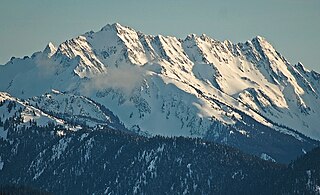
Mount Constance is a peak in the Olympic Mountains of Washington and the third highest in the range. It is the most visually prominent peak on Seattle's western skyline. Despite being almost as tall as the ice-clad Mount Olympus to the west, Mount Constance has little in the way of glaciers and permanent snow because the eastern, and particularly this northeastern, portion of the Olympics receives far less precipitation. However the narrow and steep Crystal Glacier still exists on the mountain's north face, shaded by the bulk of the main peak and with a small lake at its terminus. In addition, the treeline is higher here than mountains to the west, also hinting at the drier alpine conditions.

Mount Deception is a peak in the Olympic Mountains of Cascadia. It is in Olympic National Park on the Olympic Peninsula in the U.S. state of Washington.

Inner Constance is a summit of the Olympic Mountains and is located in Jefferson County of Washington state. It's located near the eastern edge of Olympic National Park on the Olympic Peninsula. At 7,667 feet (2,337 m) high, Inner Constance is the fifth highest peak of the Olympic Mountains, after Mount Olympus, Mount Deception, Mount Constance, and Mount Johnson. Its nearest higher peak is Mount Constance at 0.9 mi (1.4 km) to the east. Within this nearly mile-wide separation resides a deep glacially carved canyon called Avalanche Canyon. Precipitation runoff on the north side of the peak drains into tributaries of the Dungeness River, whereas the south side drains into tributaries of the Dosewallips River.

Mount Pershing is a 6,154 ft massif in the Olympic Mountains and is located in Mason County of Washington state. It is situated in the Mount Skokomish Wilderness on land managed by Olympic National Forest. The mountain's name honors General of the Armies John J. Pershing. Its nearest higher peak is Mount Washington at 1.45 mi (2.33 km) to the south-southeast. Precipitation runoff drains into the Hamma Hamma River.

Warrior Peak is a 7,320+ ft double summit mountain located in Olympic National Park in Jefferson County of Washington state. Warrior is the 11th highest peak in the Olympic Mountains Range. The southeast summit is the slightly higher of the two summits, the northwest peak is estimated at 7285 feet elevation. Warrior Peak is easy to identify from Seattle, since it appears as the first prominent peak immediately north of Mount Constance, which is the dominant peak on the skyline. Warrior's nearest higher peak is in fact Mount Constance, 0.8 mi (1.3 km) to the south-southeast. The first ascent of the mountain was made in 1945 by Fred Beckey, who solo climbed both summits, and named the mountain.

Mount Tom is a remote 7,076-foot (2,157-metre) mountain summit located within Olympic National Park in Jefferson County of Washington state. Its nearest higher neighbor is Mount Olympus, 1.76 mi (2.83 km) to the east. Due to heavy winter snowfalls, Mount Tom supports the massive White Glacier on its northeast slope, despite its modest elevation. This glacier is the westernmost glacier in the contiguous states, and the summit is the westernmost peak higher than 7000+ feet elevation. Precipitation runoff from the mountain drains into tributaries of the Hoh River.
West Peak is a 7,365-foot-high (2,245 m) peak in the Olympic Mountains, in Jefferson County of Washington state. Rising in the center of Olympic National Park, it is the highest peak on the Anderson Massif. West Peak is the hydrographic apex of the Olympic Mountains, with precipitation runoff flowing outward to the Pacific Ocean via Quinault River, the Strait of Juan de Fuca via Elwha River, and Hood Canal via the Dosewallips River. The Eel Glacier is situated in a cirque east of the summit, and an unnamed glacier resides in the south cirque. Its nearest higher peak is Mount Mystery, 7.73 miles (12.44 km) to the northeast. The first ascent of the peak was made in 1930 by E. B. Hamilton. Legend has it that the mountain's name is for Mr. West, a participant in the 1890 O'Neil Expedition, rather than for its apparent position on the Anderson Massif. The West Branch of the Quinault River was named after him in 1890.
Sentinel Peak is a 6,592-foot-high (2,009 m) mountain summit located in the Olympic Mountains, in Jefferson County of Washington state. Rising in the center of Olympic National Park, its nearest higher neighbor is Mount Fromme, 1.42 miles (2.29 km) to the northwest. Sentinels Sister is a lower 6,301-foot-high (1,921 m) companion summit situated 0.65 miles (1.05 km) to the southwest. The two peaks stand as sentinels above the Dosewalips Valley and Hayden Pass, and were possibly named by an early expedition of the Seattle Mountaineers. Precipitation runoff from the peak drains to Hood Canal via the Dosewallips River.

Mount Fricaba is a 7,139-foot-high (2,176 m) double summit mountain located in the Olympic Mountains, in Jefferson County of Washington state. It is situated on the shared border of Olympic National Park with Buckhorn Wilderness, and is the highest point in that wilderness, as well as the Olympic National Forest. Its nearest higher peak is Hal Foss Peak, 0.74 miles (1.19 km) to the southwest. Precipitation runoff from the peak drains east into headwaters of the Dungeness River, or west into Deception Creek which is a tributary of the Dosewallips River. The mountain's name was officially adopted in 1961 by the United States Board on Geographic Names based on usage by The Mountaineers since 1907, and inclusion in Fred Beckey's "Climber's Guide to the Cascade and Olympic Mountains of Washington" published in 1949. The first ascent of the mountain was made in 1957 by Don Bechlem and Jack Newman. In terms of catching favorable weather, the best months for climbing the peak are June through September.

Mount Walkinshaw is a 7,378 feet (2,249 m) mountain summit located in the Olympic Mountains, in Jefferson County of Washington state. It is situated within Olympic National Park, and is the northernmost peak in The Needles range, which is a subset of the Olympic range. Its nearest higher peak is Mount Clark, 0.9 mi (1.4 km) to the south, and Gray Wolf Ridge arcs to the northeast. Mount Walkinshaw is set in the eastern portion of the Olympic Mountains within the drainage basin of the Dungeness River. This position puts it in the rain shadow of the Olympic Range, resulting in less precipitation than Mount Olympus and the western Olympics receive.

Mount Henderson is a 6,003 ft mountain summit located in the Olympic Mountains, in Mason County of Washington state. It is situated on the shared boundary of Olympic National Park with Mount Skokomish Wilderness. Its nearest higher peak is Mount Skokomish, 0.91 mi (1.46 km) to the east-northeast. Precipitation runoff from the mountain drains into the Hamma Hamma River and Skokomish River. The mountain's name honors Louis Forniquet Henderson (1853-1942), a pioneering botanist and mountaineer who accompanied Lieutenant O'Neil on his 1890 expedition into the Olympic Mountains.

Mount Cruiser is a 6,104 ft mountain summit located in the Olympic Mountains, in Mason County of Washington state. It is situated in Mount Skokomish Wilderness on land managed by Olympic National Forest. Cruiser is the highest point on Sawtooth Ridge, and its nearest higher peak is Mount Skokomish, 2.1 mi (3.4 km) to the north-northeast. Cruiser has two sub-peaks, Alpha, and Beta, the latter of which lies on the Olympic National Park boundary. The first ascent of the peak was made in 1937 by Paul Crews and Ray Layton. The mountain was named by the first ascent party to recognize their club, the Bremerton Ski Cruisers. The mountain's name was officially adopted in 1961 by the United States Board on Geographic Names. Precipitation runoff from the mountain drains into the Hamma Hamma River.

Stephen Peak is a 6,418-foot (1,956-metre) mountain summit located within Olympic National Park in Jefferson County of Washington state. Stephen Peak is the fifth-highest peak in the Bailey Range, which is a subrange of the Olympic Mountains. In clear weather, the mountain can be seen from the visitor center at Hurricane Ridge, appearing to the left of Mount Olympus. Mount Ferry is set 2.26 mi (3.64 km) to the southeast, and Stephen's nearest higher neighbor is Ruth Peak which is an outlier of Mount Carrie, 2.1 mi (3.4 km) to the northwest. Precipitation runoff from the mountain drains into tributaries of the Elwha River and Hoh River. The first ascent of this peak was made in 1961 by Kent Heathershaw, Doug Waali, and Robert Wood.

Ruth Peak is a 6,850+ ft glaciated mountain summit located within Olympic National Park in Clallam County of Washington state. Ruth Peak is the third-highest peak in the Bailey Range, which is a subrange of the Olympic Mountains. Its nearest higher neighbor is Mount Carrie, 0.91 mi (1.46 km) to the northwest, and Mount Fairchild is set 0.92 mi (1.48 km) to the north. In clear weather, the mountain can be seen from the visitor center at Hurricane Ridge. Precipitation runoff from the mountain drains into tributaries of the Hoh and Elwha Rivers. The first ascent of this peak was made in 1961 by Bert Brown, Roy Etten, and Victor Nelson.

Fay Peak is a double-summit mountain located in Mount Rainier National Park, in Pierce County of Washington state. It is part of the Cascade Range, and lies 7 mi (11 km) northwest of the summit of Mount Rainier. The 6,492-foot elevation summit of Fay Peak lies a quarter-mile west of the highest point, East Fay Peak, 6,520+ ft. Echo Rock is its nearest higher neighbor, 2.7 mi (4.3 km) to the southeast. Precipitation runoff from Fay Peak is drained by Cataract Creek on the east side of the mountain, and the west side drains into Mowich Lake and Mowich River.

Mount Mathias is a 7,156-foot (2,181-metre) mountain summit located within Olympic National Park in Jefferson County of Washington state. Its nearest higher neighbor is Mount Olympus, 1.76 mi (2.83 km) to the east. Mount Mathias is wedged between the massive Blue Glacier below its west slope, and the Hoh Glacier on the east side. Precipitation runoff from the mountain drains into the Hoh River.
Muncaster Mountain is a 5,910-foot (1,800-metre) mountain summit located within Olympic National Park in Jefferson County of Washington state. It is situated 4.4 mi (7.1 km) south-southeast of Mount Christie, and 14.6 mi (23.5 km) southeast of Mount Olympus. Precipitation runoff from the mountain drains into Rustler Creek, which is a tributary of the Quinault River. Although modest in elevation, relief is significant as the summit rises 4,000 feet above the Rustler Creek valley in one mile.

Woden is a 6,038-foot (1,840-metre) mountain summit located within Olympic National Park in Jefferson County of Washington state. Its nearest higher neighbor is Mount Tom, 3 mi (4.8 km) to the north-northwest, and Mount Olympus rises 3.8 mi (6.1 km) to the north-northeast. Woden is the highest point in The Valhallas, a sub-range south of Mount Olympus. Precipitation runoff from the mountain drains into tributaries of the South Fork Hoh River and Queets River. The Geri-Freki Glacier, which descends north from Woden. is the only glacier in The Valhallas.
Mount Bretherton is a 5,960-foot-elevation (1,817 meter) mountain summit located in the Olympic Mountains, in Jefferson County of Washington state. It is situated within Olympic National Park, immediately south and 1,400 feet above the shore of Upper Lena Lake. Mount Lena lies across the lake to the north, Mount Stone is 2.8 miles to the west-southwest, and The Brothers approximately four miles to the northeast. Precipitation runoff from the mountain drains south to the Hamma Hamma River via Boulder, Delta, and Lena Creeks. Topographic relief is significant as it rises over 5,100 feet (1,555 meters) above the river in two miles. The non-technical ascent of Mount Bretherton involves hiking eight miles (one-way) and 5,300 feet elevation gain via the Upper Lena Lake Trail and cross-country above the lake, with most favorable conditions from July through September. There are pleasant campsites at the lake, and the ascent to the summit takes two hours from the lake. This mountain's name has been officially adopted by the United States Board on Geographic Names.


