
Mount Stimson is the second highest peak in Glacier National Park, located in Montana, United States. It is part of the Lewis Range, which spans much of the park. It is located in the remote southwestern portion of the park, approximately 5 miles (8.0 km) west of the Continental Divide and 12 miles (19 km) southeast of Lake McDonald. It is drained by Pinchot Creek and Nyack Creek, both of which flow into the Middle Fork of the Flathead River. The mountain is named for Henry L. Stimson (1867–1950), former U.S. Secretary of State and twice Secretary of War, who hiked and assisted George Bird Grinnell survey the area in and around Glacier National Park in the 1890s, and supported efforts to establish the national park.

Mount Cleveland is the highest mountain in Glacier National Park, located in Montana, United States. It is also the highest point in the Lewis Range, which spans part of the northern portion of the Park and extends into Canada. It is located approximately 3 mi (4.8 km) southeast of the southern end of Waterton Lake, and approximately 5 mi (8.0 km) south of the US/Canada border. The east side of the future national park was purchased by the federal government from the Blackfoot Confederacy in 1895 during the second term of President Cleveland. According to the United States Board on Geographic Names, the mountain is named for the former president.
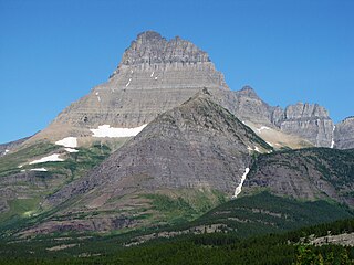
Mount Wilbur is located in the Lewis Range, Glacier National Park in the U.S. state of Montana. Plainly visible from the region of Many Glacier, the peak rises over 4,500 feet (1,372 m) above Swiftcurrent Lake and is a steep pyramid on three sides. The west slopes of the peak join to ridges along the continental divide. Much of the climbing routes are rated at class 4 to 5, with some only used once. The sedimentary rock of the mountains makes for often poor anchoring points and enhances the difficulty. A cirque on the north slopes of the mountain shelter Iceberg Lake, a popular hiking destination from Many Glacier.

Bear Mountain is located in the northern Lewis Range, Glacier National Park in the U.S. state of Montana. Cosley Lake, followed by Glenns Lake to the southwest of the mountain. Mokowanis Lake is also visible from the peak. The mountain has tremendous views of the east face of Mount Cleveland, the north face of Mount Merritt, and the east face of Chief Mountain.

Flinsch Peak is located in the Lewis Range, Glacier National Park in the U.S. state of Montana. It is 2.3 miles (3.7 km) west of Rising Wolf Mountain and straddles the Continental Divide. Viewed from Oldman Lake, the summit has a distinctive horn shape. Young Man Lake is immediately east of the peak.
Goat Haunt Mountain is located in the Lewis Range, Glacier National Park in the U.S. state of Montana. Goat Haunt Mountain is in the northeastern section of Glacier National Park, approximately 1.85 miles (2.98 km) north of Mount Cleveland. The stagnant Miche Wabun Glacier is located on the eastern slopes of the mountain. The total altitude gain from the trailhead to the mountain summit is more than 4,400 ft (1,300 m). Goat Haunt Lake is northwest of the peak.

Iceberg Peak is located in the Lewis Range, Glacier National Park in the U.S. state of Montana. Iceberg Peak rises more than 3,000 feet (910 m) above Iceberg Lake and is considered a difficult climb due to the steepness and exposure climbers must endure. The peak sits astride the continental divide 1.1 mi (1.8 km) WNW of Mount Wilbur.
Ipasha Peak is located in the Lewis Range, Glacier National Park in the U.S. state of Montana. Ipasha Peak is 1.29 miles (2.08 km) south of Mount Merritt and is in the northeastern section of Glacier National Park. Ahern Glacier is located on the southeastern slopes of the mountain while the Ipasha Glacier is to the southwest of the peak. Helen Lake lies almost 4,500 feet (1,400 m) below the summit of Ipasha Peak to the southeast.

Matahpi Peak is located in the Lewis Range, Glacier National Park in the U.S. state of Montana. Below the summit of Matahpi Peak lies Sexton Glacier. Going-to-the-Sun Mountain is just over 1 mile (1.6 km) to the south of Matahpi Peak.

Mount Helen is located in the Lewis Range, Glacier National Park in the U.S. state of Montana. Mount Helen rises immediately to the northwest roughly 3,100 feet (940 m) above Upper Two Medicine Lake in the southeastern part of Glacier National Park. The Continental Divide of the Americas passes over the summit of Mount Helen.
Mount James is located in the Lewis Range, Glacier National Park in the U.S. state of Montana. Mount James is 1.35 miles (2.17 km) northeast of Triple Divide Peak.

Natoas Peak is located in the Lewis Range, Glacier National Park in the U.S. state of Montana. Natoas Peak is 1.10 miles (1.77 km) northeast of Mount Merritt.
Norris Mountain is located in the Lewis Range, Glacier National Park in the U.S. state of Montana. Norris Mountain is situated along the Continental Divide and is less than 1 mile (1.6 km) northwest of Triple Divide Peak.

Stoney Indian Peaks are located in the Lewis Range, Glacier National Park in the U.S. state of Montana. Consisting of several summits, the mountain is in the northeastern region of Glacier National Park, less than 2 miles (3.2 km) south of Mount Cleveland. Stoney Indian Lake is south of the peaks.
Caper Peak is located in the Lewis Range, Glacier National Park in the U.S. state of Montana. Caper Peak is 1.4 miles (2.3 km) NNW of Vigil Peak.

Mount Cannon is located in the Lewis Range, Glacier National Park in the U.S. state of Montana. Formerly called Goat Mountain it was renamed for the leading physiologist Dr. Walter Bradford Cannon and his wife Cornelia, who made the first recorded ascent of the mountain in 1901.

Mount Custer is located in the Livingston Range, Glacier National Park in the U.S. state of Montana. Situated along the Continental Divide, Mount Custer rises more than 3,300 feet (1,000 m) above Lake Nooney, located below the summit to the east. Herbst Glacier is immediately northeast of the peak.

Mount Vaught is located in the Livingston Range, Glacier National Park in the U.S. state of Montana. Mount Vaught is just over 2 miles (3.2 km) SSW of Heavens Peak.

Rainbow Peak is located in the Livingston Range, Glacier National Park in the U.S. state of Montana. The namesake Rainbow Glacier is immediately east and northeast of Rainbow Peak. Rainbow Peak is the ninth-tallest mountain in Glacier National Park and rises over 1 mile (1.6 km) above Bowman Lake. From the parking lot at the Bowman Lake Campground, the elevation gain is 5,865 ft (1,788 m).
Walton Mountain is in the Lewis Range, Glacier National Park in the U.S. state of Montana. Two unnamedhanging glaciers are located to the east and northeast of the summit. Mount Jackson is 1.8 miles (2.9 km) to the north-northeast.


