Related Research Articles

Longs Peak is a high and prominent mountain summit in the northern Front Range of the Rocky Mountains of North America. The 14,259-foot (4346 m) fourteener is located in the Rocky Mountain National Park Wilderness, 9.6 miles (15.5 km) southwest by south of the Town of Estes Park, Colorado, United States. Longs Peak is the northmost "fourteener" in the Rocky Mountains and the highest point in Boulder County and Rocky Mountain National Park. The mountain was named in honor of explorer Stephen Harriman Long and is featured on the Colorado state quarter.

Mount Monadnock, or Grand Monadnock, is a 3,165 ft (965 m) mountain in the towns of Jaffrey and Dublin, New Hampshire. It is the most prominent mountain peak in southern New Hampshire and is the highest point in Cheshire County. It lies 38 miles (61 km) southwest of Concord and 62 miles (100 km) northwest of Boston. At 3,165 feet (965 m), Mount Monadnock is nearly 1,000 feet (305 m) higher than any other mountain peak within 30 miles (48 km) and rises 2,000 feet (610 m) above the surrounding landscape. It is known for being featured in the writings of Ralph Waldo Emerson and Henry David Thoreau.
Springer Mountain is a mountain located in the Chattahoochee National Forest on the border of Fannin and Gilmer counties. Located in the Blue Ridge Mountains in northern Georgia, the mountain has an elevation of about 3,782 feet (1,153 m). Springer Mountain serves as the southern terminus for the Appalachian and Benton MacKaye trails.

San Jacinto Peak is the highest peak of the San Jacinto Mountains, and of Riverside County, California. It lies within Mount San Jacinto State Park. Naturalist John Muir wrote of San Jacinto Peak, "The view from San Jacinto is the most sublime spectacle to be found anywhere on this earth!"

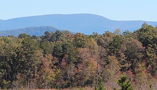
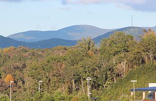
Mount Pisgah is a mountain in the Appalachian Mountain Range and part of the Blue Ridge Mountains of North Carolina, United States. The mountain's height is 5,721 feet above sea level, and it sits approximately 15 miles southwest of Asheville, near the crossing of the boundaries of Buncombe, Haywood, Henderson and Transylvania counties. It is located on the border of Buncombe and Haywood counties, close to the point where Henderson and Transylvania meet them, but not actually within the latter two counties. The mountain is easily accessible via a hiking trail from the Blue Ridge Parkway, near the Pisgah Inn.

Slide Mountain is the highest peak in the Catskill Mountains of the U.S. state of New York. It is located in the town of Shandaken in Ulster County. While the 4,180-foot (1,270 m) contour line on topographic maps is generally accepted as its height, the exact elevation of the summit has never been officially determined by the U.S. Coast and Geodetic Survey, and many informal surveys suggest the mountain may actually top 4,200 feet above sea level.

Blood Mountain is the highest peak on the Georgia section of the Appalachian Trail and the sixth-tallest mountain in Georgia, with an elevation of 4,458 feet (1,359 m). It is located on the border of Lumpkin County with Union County and is within the boundaries of the Chattahoochee National Forest and the Blood Mountain Wilderness. There are several waterfalls, hiking trails and other recreational areas in the vicinity.
Mount Cardigan is a prominent bare-rock summit in the towns of Orange and Alexandria in western New Hampshire, USA. While its peak is only 3,155 feet (962 m) above sea level, it has extensive areas of bare granite ledges and alpine scrub, giving it the feel to hikers of a much higher mountain. Most of the summit area was denuded by devastating forest fires in 1855.

Rabun Bald, with an elevation of 4,696 feet (1,431 m), is the second-highest peak in the U.S. state of Georgia; only Brasstown Bald 4,784 feet (1,458 m) is higher. It is immediately southeast of Sky Valley, Georgia, and is the tallest mountain in the county. An observation tower on the summit provides hikers with views that, on clear days, extend for more than 100 miles (160 km). The hike to the top of Rabun Bald is 5.8 miles (9.3 km) round trip via the Rabun Bald Trail. The Rabun Bald Trail connects with the Bartram Trail system, which passes over the top as it winds through northeast Georgia for 37 miles (60 km).
Rich Mountain, elevation 4,040 feet (1,230 m), is the highest point in the Rich Mountain Wilderness of the Chattahoochee National Forest in Gilmer County, Georgia. It is the second-highest peak in Gilmer County; only Big Bald Mountain is taller, with its summit at 4,081 feet (1,244 m).

Mount Oglethorpe is a mountain located in Pickens County, Georgia, USA. The southernmost peak in the Blue Ridge Mountains, the mountain has an elevation of 3,288 feet (1,002 m), making it the highest point in Pickens County.

Waterrock Knob is a mountain peak in the U.S. state of North Carolina. It is the highest peak in the Plott Balsams and is the 16th-highest mountain in the Eastern United States.

Rendezvous Mountain is a large mountain massif located in the southern Teton Range in the U.S. state of Wyoming. The highest point on Rendezvous Mountain is Rendezvous Peak. The west and northern flanks of the mountain are in Grand Teton National Park, Wyoming, while much of the remainder of the massif is in Bridger-Teton National Forest. The mountain massif extends for a distance of 5 miles (8.0 km) between Granite Canyon to the north and Phillips Canyon to the south. Though there are numerous summits above 10,000 feet (3,000 m), the one that is most commonly visited is the North Peak, where the Jackson Hole Mountain Resort aerial tram provides access to the summit for skiers in the winter and sightseerings and hikers in the summer. The hike down the Rendezvous Mountain Trail to the Granite Canyon Trail has a descent of 4,100 feet (1,200 m) over 12.3 miles (19.8 km).

The Balsam Lake Mountain Fire Observation Station is located at the summit of the mountain of that name in the Town of Hardenburgh, New York, United States. It comprises a steel frame fire lookout tower, the observer's cabin and privy and the jeep road to the complex.

McDonald Peak is located in the U.S. state of Montana and is the highest peak in the Mission Mountains. McDonald Peak is situated within the Flathead Indian Reservation. The peak has the second greatest topographic prominence of all summits within Montana and is almost 80 miles (130 km) away from the next highest mountain in the state. McDonald Glacier is on the north slope of the peak.

Pisgah Mountain or Pisgah Ridge is a long ridgeline 12.5 miles (20.1 km) Tamaqua to Jim Thorpe oriented NNE-to-SSW whose northside valley is followed by U.S. Route 209 from river gap to river gap. The ridge is a succession of peaks exceeding 1,440 feet (438.9 m) looming 300–540 feet (91–165 m) above the towns of Lansford, Coaldale, Summit Hill, and Tamaqua in the Panther Creek valley. Near Summit Hill was the 'Sharpe Mountain' (peak), where in 1791 Phillip Ginter is documented as having discovered Anthracite leading to the formation of the Lehigh Coal Mine Company. In 1818 the Lehigh Coal Company took over the mines and the mining camp gradually became a settlement and grew into Summit Hill.
Mount Pisgah is a peak in Carbon County, Pennsylvania situated north-northwest from and looming over the right bank business district in downtown Jim Thorpe.
Mauch Chunk Ridge or Mauch Chunk Mountain is a historically important barrier ridgeline north of the Blue Mountain escarpment and 3rd parallel ridgeline south of the Nesquehoning Creek after Nesquehoning Mountain and Pisgah Ridge in the Ridge-and-Valley Appalachians of Northeastern Pennsylvania. The three lengthy ridges and two valley formations together are literally the first ridges and valleys just south of the Poconos —geological formations which contain some of the richest Anthracite coal bearing sedimentary rocks of Northeastern Pennsylvania. Historically, the first Anthracite mines in America were located atop Pisgah Mountain at Summit Hill and caravanned by pack mule through the Mauch Chunk Creek valley. Then the historic Mauch Chunk and Summit Hill Switchback Railroad, the second railway in North America was built along the Pisgah Mountain side of the same valley—and become quite a tourist attraction and is known as the world's first roller coaster, and would inspire others in purpose built amusement parks. The Mauch Chunk and Summit Hill Switchback Railroad became only a tourist road in the 1890s and thrilled riders until it was liquidated in the 1930s, a casualty of the Great depression.

Pennsylvania State Game Lands Number 12 are Pennsylvania State Game Lands in Bradford County and Sullivan County, in Pennsylvania, in the United States. The game lands have an area of nearly 24,480 acres (9,910 ha) in Bradford County. The area is mainly mountainous and wooded and major streams in the area include Schrader Creek, Sugar Run, and Little Schrader Creek. Game animals within the game lands include black bear, gray squirrel, whitetail deer, and wild turkey. The main hardwood tree species include American basswood, American beech, black cherry, black birch, red maple, sugar maple, white ash, and aspen. The main conifer species include eastern hemlock, eastern larch, plantation Norway spruce, plantation red pine, and white pine.

Mount Pisgah is a peak in York County, Pennsylvania situated south-southwest of Wrightsville.
References
- Alan R. Geyer (1979) "Outstanding Geologic Features of Pennsylvania", Geological Survey of Pennsylvania
- Tom Thwaites (1997) "50 hikes in Eastern Pennsylvania", Third edition
- Art Michaels (2003) "Pennsylvania Overlooks, a guide for Sightseers and Outdoor People", Penn State Press
- "Latitude and Longitude from TopoQuest". TopoQuest.com.
Coordinates: 41°48′35″N76°42′57″W / 41.80984°N 76.71591°W
| This Bradford County, Pennsylvania state location article is a stub. You can help Wikipedia by expanding it. |