
Carbon County is a county located in the U.S. state of Pennsylvania. As of the 2010 census, the population was 65,249. Its county seat is Jim Thorpe, which was founded in 1818 as Mauch Chunk, a company town of the Lehigh Coal & Navigation Company (LC&N) along a new wagon road the company was constructing nine miles long to their coal mine, in the area now known as Summit Hill. LC&N also constructed the Lehigh Canal navigations during this time in the area.

Jim Thorpe is a borough and the county seat of Carbon County in the U.S. state of Pennsylvania. The population was 4,781 at the 2010 census. The town has been called the "Switzerland of America" due to the picturesque scenery, mountainous location, and architecture ; as well as the "Gateway to the Poconos." It is in eastern Pennsylvania about 80 miles (130 km) north of Philadelphia and 100 miles (160 km) west of New York City. This town is also historically known as the burial site for the body of Native American sports legend Jim Thorpe.

Summit Hill is a borough in Carbon County, Pennsylvania, United States. The population was 3,034 at the 2010 census. The hamlet has a storied history as the western terminus of the United States' second operational railway, the Mauch Chunk & Summit Hill Railway, and some of the earliest coal mines developed in North America, where the Lehigh Coal Mining Company began mining in 1792, establishing the town as little more than a mining camp with stables and paddocks.

This is a list of the earliest railroads in North America, including various railroad-like precursors to the general modern form of a company or government agency operating locomotive-drawn trains on metal tracks.

The Lehigh Canal or the Lehigh Navigation Canal is a navigable canal, beginning at the mouth of Nesquehoning Creek on the Lehigh River in Eastern Pennsylvania. It was built in two sections over a span of twenty years, beginning in 1818. The lower section spanned the distance between Easton, Pennsylvania and the town of Mauch Chunk, present-day Jim Thorpe, Pennsylvania. In Easton the canal met the Delaware and Morris Canals, with which goods could be brought further up the east coast. At its height, the Lehigh Canal was 72 miles (116 km) long.

Lehigh Gorge State Park is a 4,548 acres (1,841 ha) Pennsylvania state park in Luzerne and Carbon Counties, Pennsylvania in the United States. The park encompasses the Lehigh Gorge, which stretches along the Lehigh River from a U.S. Army Corps of Engineers flood control dam in Luzerne County to Jim Thorpe in Carbon County. The primary recreational activity at Lehigh Gorge State Park is white water rafting.

Nesquehoning Creek is an east flowing 14.9-mile-long (24.0 km) tributary of the Lehigh River in northeastern Pennsylvania in the United States.
The Mauch Chunk and Summit Railroad was a coal-hauling railroad in the mountains of Pennsylvania that operated between 1828 and 1932. It was the first operational US railway of any substantial length to carry paying passengers.

The Lehigh Coal and Navigation Company (LCAN) (1988–2010) was a modern-day anthracite coal mining company headquartered in Pottsville, Schuylkill County, Pennsylvania, U.S. which acquired many of the 'Old Company' (LC&N) properties and re-launched the Lehigh Coal Companies brand in 1988. The LCAN ran strip mining operations in the Panther Creek Valley east of Lansford along U.S. Route 209; with vast properties dominating the coal areas of Tamaqua, Coaldale, and Lansford. These properties are largely the same real estate assets as were acquired in the Panther Creek Valley by the predecessors: the haphazard Lehigh Coal Mine Company (1792-1822) and the builders of the Lehigh Canal and first American blast furnaces, the Lehigh Coal & Navigation Company, which spearheaded the U.S. Industrial revolution. The new company was incorporated in 1988 acquiring LC&N assets after bankruptcy proceedings, taking the name of the original.

The Lehigh Switchback Rail-Trail is a rail trail in Jim Thorpe, PA.

The Lehigh Coal & Navigation Company was a mining and transportation company that operated in Pennsylvania from 1818 to 1964. It ultimately encompassed source industries, transport, and manufacturing, making it the first vertically integrated company in the United States.
Mauch Chunk Creek is a 9.2-mile-long (14.8 km) tributary of the Lehigh River in Carbon County, Pennsylvania in the United States.

Josiah White (1781–1850) was a key Pennsylvania industrialist who began early factory centered mill production in 1808 in water powered iron works near Philadelphia, along with his partner, Erskine Hazard when they quickly found their first mill at the Falls of the Schuylkill to be much too small. Subsequently, soon after they were forced to build a much more elaborate large mill nearby to refine pig iron and produce cast iron artifacts or roll wrought bar iron goods, including nails and wire. The pair were especially important after 1814 in helping make the American Industrial Revolution not only maintain, but accelerate its building momentum by agitating for infrastructure investment, sponsoring two key river navigations and the nation's first long railway, and then after initial success, increasingly supplying an expanding part of the country's overall energy needs including that of other industrialists at a time when there occurred the prolonged first energy crisis in the brief history of the country — where forests had grown remote from population centers through over logging, charcoal and imported coal were increasing in price rapidly, and fire wood was growing dearly expensive.
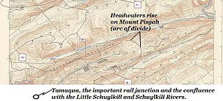
Panther Creek is a west-draining left-bank tributary of the Little Schuylkill River's drainage basin and rises in the vicinity of the east side of Lansford in the plateau-like nearly flat terrain of the complex three-way saddle between Mount Pisgah to its east, Nesquehoning Ridge to the north and Pisgah Ridge to the south, both ridgelines flanking its entire course as it makes its way ENE-to-WSW.
Pisgah Mountain or Pisgah Ridge is a long ridgeline 12.5 miles (20.1 km) Tamaqua to Jim Thorpe oriented NNE-to-SSW whose northside valley is followed by U.S. Route 209 from river gap to river gap. The ridge is a succession of peaks exceeding 1,440 feet (438.9 m) looming 300–540 feet (91–165 m) above the towns of Lansford, Coaldale, Summit Hill, and Tamaqua in the Panther Creek valley. Near Summit Hill was the 'Sharpe Mountain' (peak), where in 1791 Phillip Ginter is documented as having discovered Anthracite leading to the formation of the Lehigh Coal Mine Company. In 1818 the Lehigh Coal Company took over the mines and the mining camp gradually became a settlement and grew into Summit Hill.
Nesquehoning Mountain or Nesquehoning Ridge is a 15–17-mile-long (24–27 km) coal bearing ridge dividing the waters of Lehigh Valley to the north from the Schuylkill River valley and the several near parallel ridgelines of the Ridge-and-valley Appalachians barrier range all local members of which run generally WSW-ENE in the greater overall area.
East Mauch Chunk, organized as a Pennsylvania township when a part of 19th century Northampton County, Pennsylvania, was originally settled in the 1820s as a cross river bedroom community from both vanished Lausanne Landing and the explosively growing Mauch Chunk which it served as an upscale bedroom community, where company managers and officers were known to build homes, along with the housing built in what is known as upper Mauch Chunk. The community became a township in [TBDL: date and County] and was later organized [TBDL: 1850s? Cite History of Carbon County] as a formerly independent borough in Carbon County, Pennsylvania.
Mauch Chunk Ridge or Mauch Chunk Mountain is a historically important barrier ridgeline north of the Blue Mountain escarpment and 3rd parallel ridgeline south of the Nesquehoning Creek after Nesquehoning Mountain and Pisgah Ridge in the Ridge-and-Valley Appalachians of Northeastern Pennsylvania. The three lengthy ridges and two valley formations together are literally the first ridges and valleys just south of the Poconos —geological formations which contain some of the richest Anthracite coal bearing sedimentary rocks of Northeastern Pennsylvania. Historically, the first Anthracite mines in America were located atop Pisgah Mountain at Summit Hill and caravanned by pack mule through the Mauch Chunk Creek valley. Then the historic Mauch Chunk and Summit Hill Switchback Railroad, the second railway in North America was built along the Pisgah Mountain side of the same valley—and become quite a tourist attraction and is known as the world's first roller coaster, and would inspire others in purpose built amusement parks. The Mauch Chunk and Summit Hill Switchback Railroad became only a tourist road in the 1890s and thrilled riders until it was liquidated in the 1930s, a casualty of the Great depression.
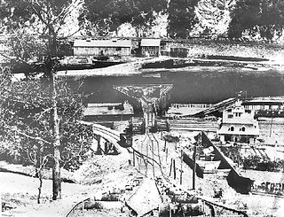
The Hauto Tunnel, dug in 1871–72, was a 1.1-mile-long (1.8 km) single-track railway tunnel crossing under the barrier ridge of Nesquehoning Mountain between Lansford, Pennsylvania, in the Panther Creek Valley and the Central Railroad of New Jersey trackage near the dam of the Hauto Reservoir impoundment about 1.3 miles (2.1 km) above Nesquehoning, Pennsylvania. The tunnel was significant for cutting nearly 15 difficult mountainous miles (24 km) off the trip to the Lehigh Canal terminal or, by rail, to other eastern coal companies, in the era when anthracite was the king of energy fuels.

Historic Lausanne, also often called Lausanne Landing of the 1790s–1820s was a small settlement at the mouth of Nesquehoning Creek on the Lehigh River in marshy delta-like flood plain. Some historic references will instead mention the 'Landing Tavern', and the reader must understand that Lausanne was a township organized in the wilderness with an almost unyielding terrain hostile to man, but along an ancient Amerindian Trail, the "Warriors' Path" the white man could not resist traveling since it connected the Susquehanna River settlements of the lower Wyoming Valley to those around Philadelphia. During the American Revolution, this route would become the rough 'Lausanne-Nescopeck Road', and after the turn of the century with a charter (1804), be improved into the wagon road toll road the Lehigh and Susquehanna Turnpike. The fan-shaped plain provided some of the flattest landscape terrain in the entire area, so could also support a few small farm plots, boat building, and a lumbermill. With the widespread deforestation creating the nation's first energy crises, what it also did was attract attention of timber and lumber companies, for the Lehigh could support river arks. The Nesquehoning Creek mouth issues behind a small river island and sits above the long curved lake-like upper pool of the Lehigh below the outlet of the gorge, and its delta's smoothly sloped sides made an attractive landing beach, giving name to the Inn. With the popularity of the route and the roughness of the country, often called "The Switzerland of America" the location was a natural rest stop for the next leg to the north involved a steep climb and was over nine miles to the area of Beaver Meadows. Hence early on it added 'Landing Tavern' to its nicknames.
At that time, all of Northampton north of the Blue Mountains was known as the Towamensing District, "Towamensing" being an Indian word for "wilderness".