Mount Pleasant, Michigan

Last updated
Mount Pleasant, Michigan
City of Mount Pleasant
MtPleasantMichiganSeal.png
Nickname: 
"Oil Capital of Michigan"
Mount Pleasant, MI location.png
Location within Isabella County
USA Michigan location map.svg
Red pog.svg
Mount Pleasant
Location within the state of Michigan
Coordinates: 43°35′52″N84°46′03″W / 43.59778°N 84.76750°W / 43.59778; -84.76750
Country Flag of the United States.svg  United States
State Flag of Michigan.svg  Michigan
County Isabella
Incorporated1889
Government
  Type Council–manager
   Mayor Amy Perschbacher
   City manager Aaron Desentz
Area
[1]
  Total7.81 sq mi (20.23 km2)
  Land7.72 sq mi (20.00 km2)
  Water0.09 sq mi (0.23 km2)  1.15%
Elevation
771 ft (235 m)
Population
 (2020)
  Total21,688
  Density2,808.60/sq mi (1,084.39/km2)
Time zone UTC-5 (EST)
  Summer (DST) UTC-4 (EDT)
ZIP Code(s)
48804 (P.O. Box)
48858 (general)
48859 (CMU)
Area code 989
FIPS code26-56020 [2]
GNIS feature ID0632832 [3]
Website Official website

Mount Pleasant is a city in the U.S. state of Michigan. The city is the county seat of Isabella County, which is part of Central Michigan. [4] The population of Mount Pleasant was 21,688 as of the 2020 census. The city is surrounded by Union Charter Township, but is politically independent.

Contents

Part of the city (with a population of 8,741) is located within the Isabella Indian Reservation, the base of the federally recognized Saginaw Chippewa Tribal Nation. The tribe's Soaring Eagle Casino & Resort in nearby Chippewa Township is also within the reservation boundaries.

Mount Pleasant is home to the main campuses of Central Michigan University, one of the largest universities in the state with 20,000 students at Mount Pleasant, and Mid Michigan Community College. The student population nearly doubles the population of the city during the academic year, making it a college town. Despite its name, the surrounding area is mostly flat and does not feature any mountains or hills.

History

1884 map of Mt. Pleasant. Mt. Pleasant, Michigan.jpg
1884 map of Mt. Pleasant.

Until the mid-19th century, this area was occupied by historical bands of the Ojibwa people, known by English speakers as the Chippewa. In the early decades of the century, they ceded vast amounts of land to the United States government, which wanted to enable settlement by European Americans.

The federal Graduation Act of 1854 allowed settlers to purchase land from the government at discount rates, and the first white settlers began to arrive in what became Mount Pleasant. Under the Treaty of 1855, the Ojibwa bands (Saginaw Chippewa Tribal Nation) from the Saginaw, Swan Creek, and Black rivers were relocated to land in Isabella County (Isabella Indian Reservation). [5]

Many non-natives soon moved to Mount Pleasant, predicting prosperous relations with the natives. The Homestead Act of 1862 also attracted many new settlers to Mount Pleasant, including new European immigrants, They worked to develop their stake on free lands offered by the US government in exchange for their labor in developing it for residence and agriculture.

The village and future city developed. In 1875, a devastating fire started at the Fancher Building on the north corner of Broadway and Main streets. It moved east down Broadway, destroying several buildings. Seven years later another fire would damage buildings on the south side of Broadway.

In 1879 the first library was established in Mt. Pleasant. Known as "The Library, Literary, and Musical Association of Mount Pleasant," its first books were made up of the personal book collections of the board members. [5]

In 1890, W.A. Jordan started Mount Pleasant Business College. Expanding in 1892, the school changed its name to Central Michigan Normal School and Business Institute, as it incorporated a curriculum of teacher training. It was the origin of what is now Central Michigan University. The Mt. Pleasant main campus is the largest of 8 CMU locations in the state, with just over 10,000 undergrad students living on campus or campus affiliated housing in the fall of 2022.

On January 3, 1893, the U.S. government opened an Indian boarding school called the Mount Pleasant Indian Industrial Boarding School. Indian children were forced to give up their cultural ways and assimilate to using the English language and adopting European-American culture. The school operated for 40 years, closing in 1933.

Since the late 20th and early 21st centuries, the role of such schools has been re-evaluated and the damage done to children by such efforts has been acknowledged. Various Native American groups have taken action to help people reconcile their experiences. On July 17, 2009, the White Bison Wellbriety Journey for Forgiveness made a stop in the Mount Pleasant community to recognize this part of the city's history. The boarding school building was abandoned, but the Saginaw Chippewa Tribal Nation purchased it from the state of Michigan.

In 1928, large quantities of oil were discovered in the Mt. Pleasant area. A farm owned by the Lilly family was the first to strike, producing hundreds of barrels a day. Although oil resources eventually diminished, this legacy is represented in the Mt. Pleasant city seal, which includes an image of an oil drill. Mt. Pleasant High School's mascot, the Oiler, also refers to the city's history of oil production. The city eventually became known as the "Oil Capital of Michigan". [6]

Geography

According to the United States Census Bureau, the city has a total area of 7.83 square miles (20.28 km2), of which 7.74 square miles (20.05 km2) is land and 0.09 square miles (0.23 km2) is water. [7] The Chippewa River runs through the city. Mount Pleasant is located approximately 61 miles (98 km) north of Lansing, Michigan's state capital, along US 127.

Climate

Climate data for Mount Pleasant, Michigan (Central Michigan University) 1991–2020 normals, extremes 1895–present
MonthJanFebMarAprMayJunJulAugSepOctNovDecYear
Record high °F (°C)60
(16)
67
(19)
87
(31)
91
(33)
97
(36)
103
(39)
106
(41)
108
(42)
99
(37)
88
(31)
77
(25)
69
(21)
108
(42)
Mean daily maximum °F (°C)29.5
(−1.4)
32.3
(0.2)
42.7
(5.9)
56.2
(13.4)
69.4
(20.8)
79.5
(26.4)
83.7
(28.7)
81.5
(27.5)
74.0
(23.3)
60.2
(15.7)
45.8
(7.7)
34.8
(1.6)
57.5
(14.2)
Daily mean °F (°C)22.7
(−5.2)
24.4
(−4.2)
33.1
(0.6)
45.1
(7.3)
57.6
(14.2)
68.0
(20.0)
72.2
(22.3)
70.2
(21.2)
62.6
(17.0)
50.3
(10.2)
38.3
(3.5)
28.6
(−1.9)
47.8
(8.8)
Mean daily minimum °F (°C)15.9
(−8.9)
16.5
(−8.6)
23.6
(−4.7)
34.0
(1.1)
45.8
(7.7)
56.5
(13.6)
60.7
(15.9)
59.0
(15.0)
51.3
(10.7)
40.5
(4.7)
30.9
(−0.6)
22.4
(−5.3)
38.1
(3.4)
Record low °F (°C)−25
(−32)
−30
(−34)
−18
(−28)
−3
(−19)
20
(−7)
25
(−4)
31
(−1)
36
(2)
27
(−3)
13
(−11)
−6
(−21)
−14
(−26)
−30
(−34)
Average precipitation inches (mm)2.11
(54)
1.72
(44)
1.95
(50)
3.57
(91)
3.71
(94)
3.87
(98)
3.22
(82)
3.84
(98)
2.82
(72)
3.52
(89)
2.79
(71)
2.35
(60)
35.47
(901)
Source: NOAA [8] [9]

Demographics

Historical population
CensusPop.Note
1880 1,115
1890 2,701142.2%
1900 3,66235.6%
1910 3,9728.5%
1920 4,81921.3%
1930 5,2118.1%
1940 8,41361.4%
1950 11,39335.4%
1960 14,87530.6%
1970 20,52438.0%
1980 23,74615.7%
1990 23,285−1.9%
2000 25,94611.4%
2010 26,0160.3%
2020 21,688−16.6%
U.S. Decennial Census [10]

2010 census

As of the census [11] of 2010, there were 26,016 people, 8,376 households, and 3,100 families living in the city. The population density was 3,361.2 inhabitants per square mile (1,297.8/km2). There were 8,981 housing units at an average density of 1,160.3 per square mile (448.0/km2). The racial makeup of the city was 87.6% White, 3.9% African American, 2.0% Native American, 3.0% Asian, 0.6% from other races, and 2.8% from two or more races. Hispanic or Latino of any race were 3.3% of the population.

There were 8,376 households, of which 18.7% had children under the age of 18 living with them, 24.3% were married couples living together, 9.3% had a female householder with no husband present, 3.4% had a male householder with no wife present, and 63.0% were non-families. 31.6% of all households were made up of individuals, and 8.6% had someone living alone who was 65 years of age or older. The average household size was 2.35 and the average family size was 2.86.

The median age in the city was 22 years. 11% of residents were under the age of 18; 53.1% were between the ages of 18 and 24; 16.8% were from 25 to 44; 11.9% were from 45 to 64; and 7.2% were 65 years of age or older. The gender makeup of the city was 47.4% male and 52.6% female.

2000 census

As of the census [2] of 2000, there were 25,946 people, 8,449 households, and 3,126 families living in the city. The population density was 3,327.2 inhabitants per square mile (1,284.6/km2). There were 8,878 housing units at an average density of 1,138.5 per square mile (439.6/km2). The racial makeup of the city was 89.12% White, 3.67% African American, 1.54% Native American, 2.85% Asian, 0.07% Pacific Islander, 0.93% from other races, and 1.83% from two or more races. Hispanic or Latino of any race were 2.49% of the population.

There were 8,449 households, out of which 18.8% had children under the age of 18 living with them, 25.9% were married couples living together, 8.5% had a female householder with no husband present, and 63.0% were non-families. 29.6% of all households were made up of individuals, and 8.8% had someone living alone who was 65 years of age or older. The average household size was 2.38 and the average family size was 2.88.

In the city, the population was spread out, with 11.5% under the age of 18, 54.1% from 18 to 24, 16.9% from 25 to 44, 10.2% from 45 to 64, and 7.3% who were 65 years of age or older. The median age was 22 years. For every 100 females, there were 82.4 males. For every 100 females age 18 and over, there were 80.2 males.

The median income for a household in the city was $24,572, and the median income for a family was $43,927. Males had a median income of $32,004 versus $23,869 for females. The per capita income for the city was $13,177. About 11.4% of families and 37.2% of the population (student population skews this statistic) were below the poverty line, including 14.8% of those under age 18 and 7.6% of those age 65 or over.

Transportation

Education

Local media

Newspapers
Radio stations
TV stations

Notable people

Sister cities

Related Research Articles

<span class="mw-page-title-main">Midland County, Michigan</span> County in Michigan, United States

Midland County is a county located in the U.S. state of Michigan. As of the 2020 census, the population was 83,494. The county seat is Midland. The county's name is due to its closeness to the geographical Lower Peninsula's geographical center. It was founded in 1831. However, it was not until 1855 that the county was effectively organized.

<span class="mw-page-title-main">Isabella County, Michigan</span> County in Michigan, United States

Isabella County is a county located in the U.S. state of Michigan. As of the 2020 Census, the population was 64,394. Its county seat is Mount Pleasant. The area was known as Ojibiway Besse, meaning "the place of the Ojibwa". Isabella County contains the Isabella Indian Reservation, on which members of the Saginaw Chippewa Tribal Nation live.

<span class="mw-page-title-main">Arenac County, Michigan</span> County in Michigan, United States

Arenac County is a county located in the U.S. state of Michigan. As of the 2020 Census, the population was 15,002. The county seat is Standish.

<span class="mw-page-title-main">Mount Pleasant, Iowa</span> City in Iowa, United States

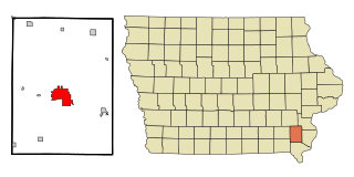
Mount Pleasant is a city in and the county seat of Henry County in the U.S. state of Iowa. The population was 9,274 in the 2020 census, an increase from 8,668 in the 2010 census. It was founded in 1835 by pioneer Presley Saunders.

<span class="mw-page-title-main">Alma, Michigan</span> City in Michigan, United States

Alma is the largest city in Gratiot County in the U.S. state of Michigan. The population was 9,488 at the 2020 census. It was incorporated as the Village of Alma in 1872 and became a city in 1905.

<span class="mw-page-title-main">Tawas City, Michigan</span> City in Michigan, United States

Tawas City is a city in and county seat of Iosco County in the U.S. state of Michigan. The population was 1,834 at the 2020 census. The city is mostly surrounded by Tawas Township, but the two areas are administered autonomously.

<span class="mw-page-title-main">Chippewa Township, Isabella County, Michigan</span> Civil township in Michigan, United States

Chippewa Township is a civil township of Isabella County in the U.S. state of Michigan. As of the 2020 census, the township population was 4,446. The city of Mount Pleasant is nearby to the west, and the Mount Pleasant post office, with ZIP code 48858, also serves the northern portion of Chippewa Township.

<span class="mw-page-title-main">Nottawa Township, Isabella County, Michigan</span> Civil township in Michigan, United States

Nottawa Township is a civil township of Isabella County in the U.S. state of Michigan. The population was 2,225 at the 2020 census.

<span class="mw-page-title-main">Sherman Township, Isabella County, Michigan</span> Civil township in Michigan, United States

Sherman Township is a civil township of Isabella County in the U.S. state of Michigan. The population was 3,127 at the 2020 census.

<span class="mw-page-title-main">Union Charter Township, Michigan</span> Charter township in Michigan, United States

Union Charter Township is a charter township of Isabella County in the U.S. state of Michigan. The population was 12,927 at the 2010 census, and decreased to 11,699 at the 2020 census. The city of Mount Pleasant is entirely surrounded by the township on incorporated land that was formerly part of the township, but the two are administratively separately.

<span class="mw-page-title-main">Weidman, Michigan</span> Census-designated place & unincorporated community in Michigan, United States

Weidman is an unincorporated community in Isabella County, Michigan, United States. It is a census-designated place (CDP) for statistical purposes, but has no independent municipal authority. The population of the CDP was 959 at the 2010 census, up from 879 at the 2000 census.

<span class="mw-page-title-main">Barryton, Michigan</span> Village in Michigan, United States

Barryton is a village in Mecosta County in the U.S. state of Michigan. The population was 405 at the 2020 census, up from 355 in 2010. The village is located in Fork Township on M-66.

Chippewa Township is a civil township of Mecosta County in the U.S. state of Michigan. As of the 2020 census, the township population was 1,227.

<span class="mw-page-title-main">Greendale Township, Michigan</span> Civil township in Michigan, United States

Greendale Township is a civil township of Midland County in the U.S. state of Michigan. As of the 2020 census, the township population was 1,731.

<span class="mw-page-title-main">Homer Township, Midland County, Michigan</span> Civil township in Michigan, United States

Homer Township is a civil township of Midland County in the U.S. state of Michigan. As of the 2020 census, the township population was 3,993.

<span class="mw-page-title-main">Jasper Township, Michigan</span> Civil township in Michigan, United States

Jasper Township is a civil township of Midland County in the U.S. state of Michigan. The population was 1,060 at the 2020 census.

<span class="mw-page-title-main">Chesaning, Michigan</span> Village in Michigan, United States

Chesaning is a village in Saginaw County in the U.S. state of Michigan. The population was 2,394 at the 2010 census. The village is located within Chesaning Township.

<span class="mw-page-title-main">Freeland, Michigan</span> Census-designated place & unincorporated community in Michigan, United States

Freeland is a census-designated place in Tittabawassee Township, Saginaw County in the U.S. state of Michigan. It is part of the Saginaw-Midland-Bay Metropolitan Area. As of the 2000 census, the CDP population was 5,147. The CDP covers an area in the central portion of Tittabawassee Township. The Freeland post office, ZIP code 48623, serves nearly the entire township, as well as portions of Midland and Williams townships to the north, Frankenlust and Kochville townships to the east, Thomas and Richland townships to the south, and Ingersoll Township to the west.

<span class="mw-page-title-main">Saginaw Charter Township, Michigan</span> Charter township in Michigan, United States

Saginaw Charter Township is a charter township of Saginaw County in the U.S. state of Michigan. The population was 41,679 at the 2020 census. The city of Saginaw is adjacent to the township to the southeast, but is administratively autonomous.

<span class="mw-page-title-main">Midland, Michigan</span> City in Michigan, United States

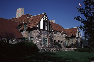
Midland is a city in and the county seat of Midland County, Michigan, in the United States. The city's population was 42,547 as of the 2020 census. It is the principal city of the Midland Metropolitan Statistical Area, part of the larger Saginaw-Midland-Bay City Combined Statistical Area.

References

  1. "2020 U.S. Gazetteer Files". United States Census Bureau. Retrieved May 21, 2022.
  2. 1 2 "U.S. Census website". United States Census Bureau . Retrieved 2008-01-31.
  3. "Mount Pleasant". Geographic Names Information System . United States Geological Survey, United States Department of the Interior.
  4. "Find a County". National Association of Counties. Retrieved 2011-06-07.
  5. 1 2 Cumming, John. This Place Mount Pleasant. Mount Pleasant, MI: J. Cumming, 1989.
  6. "History of Michigan's Oil and Natural Gas Industry | Clarke Historical Library". www.cmich.edu. Retrieved 2023-04-21.
  7. "US Gazetteer files 2010". United States Census Bureau. Archived from the original on 2011-02-20. Retrieved 2012-11-25.
  8. "NowData - NOAA Online Weather Data". National Oceanic and Atmospheric Administration. Retrieved September 4, 2021.
  9. "Station: Central Michigan UNIV, MI". U.S. Climate Normals 2020: U.S. Monthly Climate Normals (1991–2020). National Oceanic and Atmospheric Administration. Retrieved September 4, 2021.
  10. "Census of Population and Housing". Census.gov. Retrieved June 4, 2015.
  11. "U.S. Census website". United States Census Bureau . Retrieved 2012-11-25.
  12. "About The Morning Sun". The Morning Sun. Archived from the original on 2008-07-04.
  13. "About Central Michigan Life". cm-life.com. Archived from the original on 2008-04-18.
  14. "About The Pulse". Central Michigan Pulse. Archived from the original on 2016-01-31.
  15. "Mount Pleasant Four Corners". Chippewa River District Library System. Retrieved 2022-10-28.
  16. Fox, Margalit (2004-10-15). "John Tebbel, 91, Writer and Historian of Publishing, Dies". The New York Times. ISSN   0362-4331 . Retrieved 2022-06-23.
  17. 1 2 "City of Mt. Pleasant, Michigan". Archived from the original on 2008-10-15. Retrieved 2008-09-14.