Reed City, Michigan

Last updated
Reed City, Michigan
Osceola County Courthouse (Reed City).jpg
Osceola County Courthouse
Motto: 
Your Crossroads Community on the Path to Progress...
Osceola County Michigan Incorporated and Unincorporated areas Reed City Highlighted.svg
Location of Reed City, Michigan
Coordinates: 43°52.5′N85°30.6′W / 43.8750°N 85.5100°W / 43.8750; -85.5100
Country United States
State Michigan
County Osceola
Area
[1]
  Total2.13 sq mi (5.53 km2)
  Land2.10 sq mi (5.44 km2)
  Water0.03 sq mi (0.09 km2)
Elevation
1,040 ft (317 m)
Population
 (2020)
  Total2,490
  Density1,184.59/sq mi (457.32/km2)
Time zone UTC-5 (Eastern (EST))
  Summer (DST) UTC-4 (EDT)
ZIP code
49677
Area code 231
FIPS code 26-67820 [2]
GNIS feature ID1621363 [3]

Reed City is a city in the U.S. state of Michigan. The population was 2,490 at the 2020 census. It is located in southwestern Osceola County and is the county seat. [4]

Contents

Geography

According to the United States Census Bureau, the city has a total area of 2.11 square miles (5.46 km2), of which 2.08 square miles (5.39 km2) is land and 0.03 square miles (0.08 km2) is water. [5]

The Hersey River flows through Reed City.

Demographics

Historical population
CensusPop.Note
1880 1,091
1890 1,77662.8%
1900 2,05115.5%
1910 1,690−17.6%
1920 1,8036.7%
1930 1,792−0.6%
1940 1,8453.0%
1950 2,24121.5%
1960 2,184−2.5%
1970 2,2864.7%
1980 2,221−2.8%
1990 2,3797.1%
2000 2,4302.1%
2010 2,425−0.2%
2020 2,4902.7%
U.S. Decennial Census [6]

2020 census

At the 2020 census there were 2,465 people. The population density was 1,172.6 per square mile (452.7/km2).

2010 census

At the 2010 census, [7] there were 2,425 people, 1,007 households, and 582 families living in the city. The population density was 1,165.9 per square mile (450.2/km2). There were 1,136 housing units at an average density of 546.2 per square mile (210.9/km2). The racial make-up of the city was 94.8% White, 1.7% African American, 0.5% Native American, 0.2% Asian, 0.3% from other races and 2.5% from two or more races. Hispanic or Latino of any race were 2.2% of the population.

There were 1,007 households, of which 33.3% had children under the age of 18 living with them, 35.3% were married couples living together, 16.8% had a female householder with no husband present, 5.8% had a male householder with no wife present, and 42.2% were non-families. 38.7% of all households were made up of individuals, and 15.6% had someone living alone who was 65 years of age or older. The average household size was 2.26 and the average family size was 2.98.

The median age was 36.1 years. 26.4% of residents were under the age of 18, 9.6% were between the ages of 18 and 24, 25.1% were from 25 to 44, 21.4% were from 45 to 64 and 17.5% were 65 years of age or older. The sex make-up of the city was 44.9% male and 55.1% female.

2000 census

At the 2000 census, [2] there were 2,430 people, 999 households and 609 families living in the city. The population density was 1,265.3 per square mile (488.5/km2). There were 1,090 housing units at an average density of 567.5 per square mile (219.1/km2). The racial make-up was 95.84% White, 1.07% African American, 0.74% Native American, 0.21% Asian, 0.12% from other races, and 2.02% from two or more races. Hispanic or Latino of any race were 0.91% of the population.

There were 999 households, of which 31.2% had children under the age of 18 living with them, 40.2% were married couples living together, 16.4% had a female householder with no husband present, and 39.0% were non-families. 33.4% of all households were made up of individuals, and 14.4% had someone living alone who was 65 years of age or older. The average household size was 2.30 and the average family size was 2.93.

25.6% of the population were under the age of 18, 11.4% from 18 to 24, 25.4% from 25 to 44, 19.8% from 45 to 64 and 17.7% were 65 years of age or older. The median age was 36 years. For every 100 females, there were 84.2 males. For every 100 females age 18 and over, there were 80.8 males.

The median household income was $30,756 and the median family income was $42,340. Males had a median income of $29,375 and females $25,263. The per capita income was $15,889. About 10.9% of families and 17.9% of the population were below the poverty line, including 16.6% of those under age 18 and 14.2% of those age 65 or over.

Infrastructure

Transportation

The city is also at the crossroads of two US highways:

Indian Trails provides daily intercity bus service between Grand Rapids and Petoskey, Michigan. [8]

Two of the state's premier rail trails intersect in the city:

Historical transportation

The Pennsylvania Railroad ran trains from Grand Rapids to Cadillac, Petoskey and Mackinaw City on a route that includes land used now for the White Pine Trail, making stops in Reed City's union station. Immediate connections in Grand Rapids with sleepers to eastern Indiana and Cincinnati were part of the schedule. Reed City was the closest PRR station to Idlewild, a significant African-American resort until the 1960s. In the final years, service through the town was reduced to summer only. [9] Passenger service ended between 1954 and 1955. [10]

The Pere Marquette Railway ran trains west from Reed City to Ludington and east to Saginaw, on a route that is included in the above cited rail trail. At Saginaw the trains were timed to meet with separate Bay City-originating trains to Detroit. The PM's successor, the Chesapeake and Ohio Railway, ended the Ludington to Saginaw trains in the latter months of 1949. [11]

Notable people

Related Research Articles

<span class="mw-page-title-main">Thornburg, Iowa</span> City in Iowa, United States

Thornburg is a village in Keokuk County, Iowa, United States. The population was 45 at the time of the 2020 census. Its sole enterprise is the Tri-County Community School, a public school serving grades K-12.

<span class="mw-page-title-main">Rock Rapids, Iowa</span> City in Iowa, United States

Rock Rapids is a city in and the county seat of Lyon County, Iowa, United States. The population was 2,611 in the 2020 census, an increase from 2,573 in the 2000 census.

<span class="mw-page-title-main">Au Gres, Michigan</span> City in Michigan, United States

Au Gres is a city in Arenac County in the U.S. state of Michigan. The population was 945 at the 2020 census.

<span class="mw-page-title-main">Pinconning, Michigan</span> City in Michigan, United States

Pinconning is a city in Bay County in the U.S. state of Michigan. The population was 1,204 at the 2020 census. It is included in the Saginaw, Midland, and Bay City metropolitan area. The city is locally noted for its former production of cheese and cheese products, especially Pinconning cheese.

<span class="mw-page-title-main">Thompsonville, Michigan</span> Village in Michigan, United States

Thompsonville is a village in Benzie County in the U.S. state of Michigan. The village had a population of 451 at the 2020 census, up from 441 at the 2010 census. The village lies immediately north of the Manistee County line, and is divided between Colfax and Weldon townships.

<span class="mw-page-title-main">Pellston, Michigan</span> Village in Michigan, United States

Pellston is a village in Emmet County in the U.S. state of Michigan. The population was 822 at the 2010 census. The village is the home of Pellston Regional Airport.

<span class="mw-page-title-main">Petoskey, Michigan</span> City in Michigan, United States

Petoskey is a city in the U.S. state of Michigan. It is the county seat of Emmet County, and is the largest settlement within the county. Petoskey has a population of 5,877 at the 2020 census, up from 5,670 at the 2010 census.

<span class="mw-page-title-main">Alma, Michigan</span> City in Michigan, United States

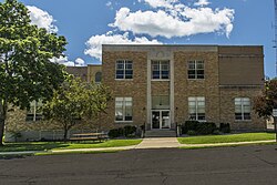
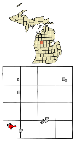
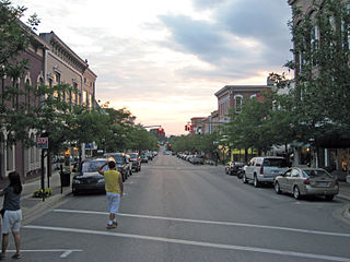
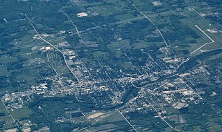
Alma is the largest city in Gratiot County in the U.S. state of Michigan. The population was 9,488 at the 2020 census. It was incorporated as the Village of Alma in 1872 and became a city in 1905.

<span class="mw-page-title-main">Cedar Springs, Michigan</span> City in Michigan, United States

Cedar Springs is a city in Kent County in the U.S. state of Michigan. The population was 3,509 at the 2010 census. Cedar Springs is a northern city of the Grand Rapids metropolitan area and is about 20 miles (32.2 km) north of Grand Rapids.

<span class="mw-page-title-main">Courtland Township, Michigan</span> Township in Michigan, United States

Courtland Township is a civil township of Kent County in the U.S. state of Michigan. The population was 9,005 at the 2020 census, which was an increase from 7,678 at the 2010 census.

<span class="mw-page-title-main">East Grand Rapids, Michigan</span> City in Michigan, United States

East Grand Rapids is a city in Kent County in the U.S. state of Michigan. As of the 2020 census, the population was 11,371.

<span class="mw-page-title-main">Rockford, Michigan</span> City in Michigan, United States

Rockford is a city in Kent County in the U.S. state of Michigan. The population was 6,177 at the 2020 census.

<span class="mw-page-title-main">Big Rapids, Michigan</span> City in Michigan, United States

Big Rapids is a city and the county seat of Mecosta County, Michigan. The population was 7,727 at the 2020 census, down from 10,601 in 2010. The city is surrounded by Big Rapids Charter Township but they are completely separate jurisdictions. Big Rapids is home of the main campus of Ferris State University, a four-year public university.

<span class="mw-page-title-main">Morley, Michigan</span> Village in Michigan, United States

Morley is a village in Mecosta County in the U.S. state of Michigan. The population was 517 at the 2020 census.

<span class="mw-page-title-main">Stanwood, Michigan</span> Village in Michigan, United States

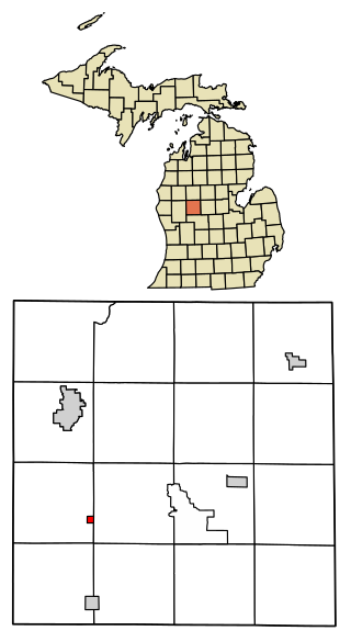
Stanwood is a village in Mecosta County of the U.S. state of Michigan. The population was 194 at the 2020 census. The village is within Mecosta Township.

<span class="mw-page-title-main">Howard City, Michigan</span> Village in Michigan, United States

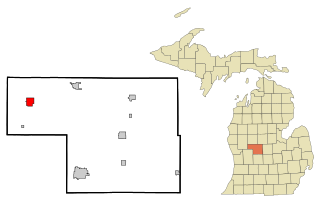
Howard City is a village in Montcalm County in the U.S. state of Michigan. The population was 1,835 at the 2020 census. The village is within Reynolds Township.

<span class="mw-page-title-main">Newaygo, Michigan</span> City in Michigan, United States

Newaygo is a rural city in Newaygo County in the U.S. state of Michigan. The population was 2,471 at the 2020 census.

Chester Township is a civil township of Ottawa County in the U.S. state of Michigan. As of the 2020 United States Census, the township population was 2,096.

<span class="mw-page-title-main">Saginaw Charter Township, Michigan</span> Charter township in Michigan, United States

Saginaw Charter Township is a charter township of Saginaw County in the U.S. state of Michigan. The population was 41,679 at the 2020 census. The city of Saginaw is adjacent to the township to the southeast, but is administratively autonomous.

<span class="mw-page-title-main">Chesapeake, West Virginia</span> Town in West Virginia, United States

Chesapeake is a town in Kanawha County, West Virginia, United States. The population was 1,336 at the 2020 census. The town is situated on the Kanawha River.

References

  1. "2020 U.S. Gazetteer Files". United States Census Bureau. Retrieved May 21, 2022.
  2. 1 2 "U.S. Census website". United States Census Bureau . Retrieved January 31, 2008.
  3. "US Board on Geographic Names". United States Geological Survey. October 25, 2007. Retrieved January 31, 2008.
  4. "Find a County". National Association of Counties. Retrieved June 7, 2011.
  5. "US Gazetteer files 2010". United States Census Bureau. Archived from the original on February 20, 2011. Retrieved November 25, 2012.
  6. "Census of Population and Housing". Census.gov. Retrieved June 4, 2015.
  7. "U.S. Census website". United States Census Bureau . Retrieved November 25, 2012.
  8. "Grand Rapids–Cadillac–Traverse City–Petoskey" (PDF). Indian Trails. January 15, 2013. Retrieved March 9, 2013.[ permanent dead link ]
  9. Pennsylvania Railroad timetable, January 18, 1954, Table 30 (no passenger service north of Grand Rapids)
  10. "Pennsylvania Railroad, Table 100". Official Guide of the Railways. 87 (7). National Railway Publication Company. December 1954.
    - "Pennsylvania Railroad, Table 230, freight only". Official Guide of the Railways. 88 (4). National Railway Publication Company. September 1955.
  11. "Chesapeake and Ohio Railway, Tables 50, 53". Official Guide of the Railways. 82 (3). National Railway Publication Company. August 1949.
    - "Chesapeake and Ohio Railway, Table 53, freight only, November 1950 schedule". Official Guide of the Railways. 82 (8). National Railway Publication Company. January 1950.
  12. Biographical Sketch of William C. Giese, Wisconsin Blue Book 1954, pg. 60