The mountain was named on April 29, 1890, by James Halbold Christie, leader of the 1889–90 Seattle Press Expedition, and Charles Adams Barnes, the expedition's topographer. Christie was sponsored by the Seattle newspaper Press, and named the mountain in honor of the city of Seattle. Observations from Mount Seattle enabled Barnes to finally complete his map of the Olympic Mountains.[4]
The first documented ascent of the summit was made in 1907 by Asahel Curtis, Grant Humes, and Lorenz Nelson who were reconnoitering for The Mountaineers first ascent attempt at Mount Olympus.[1] Three scramble routes to the summit have been established: via Noyes Basin, via Seattle Creek Basin, and via Low Divide.[1]
Climate
Based on the Köppen climate classification, Mount Seattle is located in the marine west coast climate zone of western North America.[5]Weather fronts originating in the Pacific Ocean travel northeast toward the Olympic Mountains. As fronts approach, they are forced upward by the peaks (orographic lift), causing them to drop their moisture in the form of rain or snow. As a result, the Olympics experience high precipitation, especially during the winter months in the form of snowfall.[6] Because of maritime influence, snow tends to be wet and heavy, resulting in avalanche danger. During winter months weather is usually cloudy, but due to high pressure systems over the Pacific Ocean that intensify during summer months, there is often little or no cloud cover during the summer.[6] The months June through August offer the most favorable weather for viewing or climbing this mountain.[1]
Geology
The Olympic Mountains are composed of obductedclastic wedge material and oceanic crust, primarily Eocenesandstone, turbidite, and basaltic oceanic crust.[7] The mountains were sculpted during the Pleistocene era by erosion and glaciers advancing and retreating multiple times.
Gallery
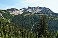
West aspect
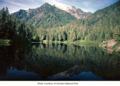
East aspect, reflected in Lake Margaret
East aspect, from Lake Margaret
Waterfalls on Mount Seattle
Seattle Press expedition members with Christie and Barnes in the center
The view from Mt. Seattle, with Mt. Christie to right.
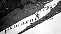
Men and women hiking up Mount Seattle, August 7, 1913
↑ Parratt, Smitty (1984). Gods and Goblins: A Field Guide to Place Names of Olympic National Park (1sted.).
↑ Peel, M. C.; Finlayson, B. L.; McMahon, T. A. (2007). "Updated world map of the Köppen−Geiger climate classification". Hydrol. Earth Syst. Sci. 11: 1633–1644. ISSN1027-5606.
1 2 McNulty, Tim (2009). Olympic National Park: A Natural History. Seattle, Washington: University of Washington Press.
This page is based on this Wikipedia article Text is available under the CC BY-SA 4.0 license; additional terms may apply. Images, videos and audio are available under their respective licenses.