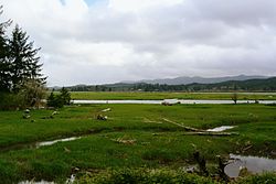
Naselle is a census-designated place (CDP) in Pacific County, Washington, United States located about 23 miles (37 km) from the mouth of the Columbia River. The population was 419 at the 2010 census. The valley's Naselle River flows west into nearby Willapa Bay and then into the Pacific Ocean. Close about the town lie the evergreen-covered Willapa Hills. The river's name has been spelled Nasel and Nasal. An early settler along the river called it the Kenebec. The name comes from the Nisal Indians, a Chinookan tribe formerly residing on the river.

The Chehalis River is a river in Washington in the United States. It originates in several forks in southwestern Washington, flows east, then north, then west, in a large curve, before emptying into Grays Harbor, an estuary of the Pacific Ocean. The river is the largest solely contained drainage basin in the state.

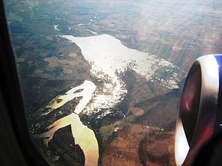
Willapa Bay is a bay located on the southwest Pacific coast of Washington state in the United States. The Long Beach Peninsula separates Willapa Bay from the greater expanse of the Pacific Ocean. With over 120 square miles (310 km2) of surface area Willapa Bay is the second-largest riverine estuary on the Pacific coast of the continental United States. Early settlers called the bay Shoalwater Bay and this name is found on old maps and charts of the region.
Grays River is a tributary of the Columbia River, approximately 30 miles (48 km) long, in southwestern Washington in the United States. One of the last tributaries of the Columbia on the Washington side, it drains an area of low hills north of the mouth of the river.

The Willapa River is a river on the Pacific coast of southwestern Washington in the United States, approximately 20 miles (32 km) long. It drains an area of low hills and a coastal plain into Willapa Bay, a large estuary north of the mouth of the Columbia River.
Moses Lake is a lake and reservoir along the course of Crab Creek, in the U.S. state of Washington.

Jennifer L. Holm is an American children's writer, and recipient of three Newbery Honors and the Eisner Award.
Doty, Washington is an unincorporated community located 1.3-miles directly west of Dryad and 5 miles east of Pe Ell on Washington State Route 6. As of 2023, approximately 250 people reside in or around Doty, which boasts a general store, post office, fire department, and two churches. Logging and farming are the industries that most of the residents rely on for income.
Lake River is a tributary, about 11 miles (18 km) long, of the Columbia River in the U.S. state of Washington. It flows north from Vancouver Lake in Vancouver to meet the larger river near Ridgefield and the northern tip of Bachelor Island. The Wilkes Expedition of 1841 referred to Lake River as Calipaya Inlet.

Lacamas Creek is in Clark County, Washington, United States, and flows about 12.5 miles (20.1 km) from headwaters near Camp Bonneville to Lacamas Lake and Round Lake in Camas, and eventually into the Washougal River. Its name is derived from that of the native camas plant. Lacamas Creek is fed by numerous streams, but the five largest tributaries are Matney Creek, Shanghai Creek, Fifth Plain Creek, China Ditch, and Dwyer Creek.

Hooper is an unincorporated community in Whitman County, Washington, United States.
The Tilton River is a tributary of the Cowlitz River, in the U.S. state of Washington. Named for territorial surveyor James Tilton, it flows for about 29 miles (47 km), entirely within Lewis County.
The Palix River is a stream in the U.S. state of Washington. Its tributaries include three forks, North, Middle, and South Fork Palix River, as well as the Canon River. The river's length, including the Canon River, its longest tributary, is approximately 14 miles (23 km).
The Dewatto River is a stream in the U.S. state of Washington. It originates in western Kitsap Peninsula and flows south, emptying into Hood Canal. The name "Dewatto" comes from the Twana placename [duʔwátaxʷ], which implies the presence of spirits causing mental derangement near the stream's mouth.
Tiger is an unincorporated community in Pend Oreille County, Washington, United States. Named for early settler George Tiger, Tiger is located near Washington State Route 31 3.5 miles (5.6 km) south of Ione.

Neepaulakating Creek is a 2.4-mile long (3.8 km) tributary of Papakating Creek in Wantage Township in Sussex County, New Jersey in the United States. It is one of three streams feeding the Papakating Creek, a major contributor to the Wallkill River. Although the stream was dammed in the 1950s to create Lake Neepaulin as the focal point of a private residential development, the stream did not receive a name until 2002. Residents chose a name that combined elements of the names "Neepaulin" and "Papakating", and submitted a proposal to the United States Board of Geographic Names. The name was approved in 2004.

Lucerne is an unincorporated community in Chelan County, Washington, United States. Lucerne is assigned the ZIP code 98816.
Ceres is an unincorporated community in Lewis County, in the U.S. state of Washington. It is located off Washington State Route 6 in a bend of the Chehalis River. The Willapa Hills Trail bisects the area.
Johns River is a short tidal river flowing into the south end of Grays Harbor in the U.S. state of Washington.
The Cedar River is a short stream flowing into the north end of Willapa Bay in the U.S. state of Washington.