Columbia River, Olympic Mountains, Pacific Ocean and Cascade Range
The Willapa Hills is a geologic, physiographic, and geographic region in southwest Washington. When described as a physiographical province, the Willapa Hills are bounded by the Pacific Ocean to the west, the Columbia River to the south, the Olympic Mountains to the north, and the Cascade Range to the east.[1] Some definitions place the Puget Lowland physiographic province east of the Willapa Hills.[2] Included within the province are the Black Hills, the Doty Hills, and a number of broad river valleys, some of which open up into broad estuaries on the Pacific such as Grays Harbor and Willapa Bay.[2] Other definitions do not include the Black Hills.[3] The USGSGNIS defines the Willapa Hills as bounded by the Columbia River to the south and the Chehalis River to the north, without giving specific east and west bounds.[4] The Willapa Hills are one of the Pacific Coast Ranges, which continue north as the Olympic Mountains and south, across the Columbia River, as the Oregon Coast Range.
The highest point is 3,087-foot (941m)Boistfort Peak. The Willapa Hills are the lowest uplands in the entire Pacific Coast Range system. Almost all of the land is privately held and has been repeatedly logged. Only a few long corners remain with virgin forest. Alders less than twenty years old are typically harvested for pulp mills.
↑ Ares, Adrian (2007). The Fall River long-term site productivity study in coastal Washington. General Technical Report, Forest Service Pacific Northwest Research Station. DIANE Publishing. p.15. ISBN978-1-4223-2472-1.
Moclips is an unincorporated community and census-designated place (CDP) in Grays Harbor County, Washington, United States. The population was 207 at the 2010 census. It is located near the mouth of the Moclips River.
The Pacific Coast Ranges are the series of mountain ranges that stretch along the West Coast of North America from Alaska south to Northern and Central Mexico. Although they are commonly thought to be the westernmost mountain range of the continental United States and Canada, the geologically distinct Insular Mountains of Vancouver Island lie farther west.
The Chehalis River is a river in Washington in the United States. It originates in several forks in southwestern Washington, flows east, then north, then west, in a large curve, before emptying into Grays Harbor, an estuary of the Pacific Ocean.
The Chehalis people or Tsihalis are a native people of western Washington state in the United States. They should not be confused with the similarly named Chehalis First Nation of the Sts'Ailes people along the Harrison River in the Fraser Valley area of British Columbia.
Grays River is a tributary of the Columbia River, approximately 30 miles (48 km) long, in southwestern Washington in the United States. One of the last tributaries of the Columbia on the Washington side, it drains an area of low hills north of the mouth of the river.
The Willapa River is a river on the Pacific coast of southwestern Washington in the United States, approximately 20 miles (32 km) long. It drains an area of low hills and a coastal plain into Willapa Bay, a large estuary north of the mouth of the Columbia River.
The Interior Plateau comprises a large region of the Interior of British Columbia, and lies between the Cariboo and Monashee Mountains on the east, and the Hazelton Mountains, Coast Mountains and Cascade Range on the west. The continuation of the plateau into the United States is known there as the Columbia Plateau.
The Douglas Ranges are a subrange of the Pacific Ranges of the Coast Mountains of the Canadian province of British Columbia, about 70 km (43 mi) east of downtown Vancouver, north of the Fraser River and between the valleys of Stave and Harrison Lakes. They are approximately 4,900 km2 (1,900 sq mi) in area. Their highest peak is Mount Robertson 2,252 m (7,388 ft), at the northwest limit of the range.
The North American Cordillera, sometimes also called the Western Cordillera of North America, the Western Cordillera or the Pacific Cordillera, is the North American portion of the American Cordillera, the mountain chain system (cordillera) along the western coast of the Americas. The North American Cordillera covers an extensive area of mountain ranges, intermontane basins and plateaus in Western/Northwestern Canada, Western United States and Mexico, including much of the territory west of the Great Plains.
The Oregon Coast Range, often called simply the Coast Range and sometimes the Pacific Coast Range, is a mountain range, in the Pacific Coast Ranges physiographic region, in the U.S. state of Oregon along the Pacific Ocean. This north-south running range extends over 200 miles (320 km) from the Columbia River in the north on the border of Oregon and Washington, south to the middle fork of the Coquille River. It is 30 to 60 miles wide and averages around 1,500 feet (460 m) in elevation above sea level. The coast range has three main sections, a Northern, Central, and Southern.
U.S. Route 101 (US 101) is a United States Numbered Highway that runs along the West Coast from Los Angeles, California to Tumwater, Washington. Within the state of Washington, US 101 connects cities on the coast of the Pacific Ocean and encircles the Olympic Peninsula around the Olympic Mountains. It also serves as the main access for Olympic National Park, several state parks, and other scenic and recreational areas.
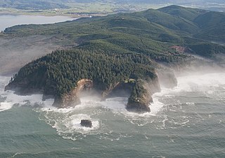
The Coast Range ecoregion is a Level III ecoregion designated by the Environmental Protection Agency (EPA) in the U.S. states of Washington, Oregon, and California. It stretches along the Pacific Coast from the tip of the Olympic Peninsula in the north to the San Francisco Bay in the south, including Grays Harbor, Willapa Bay, and the Long Beach Peninsula in Washington, the entire length of the Oregon Coast, and the Northern California Coast. Named for the Coast Range mountains, it encompasses the lower elevations of the Olympic Mountains, the Oregon Coast Range, the Californian North Coast Ranges, and surrounding lowlands.
The Palix River is a stream in the U.S. state of Washington. Its tributaries include three forks, North, Middle, and South Fork Palix River, as well as the Canon River. The river's length, including the Canon River, its longest tributary, is approximately 14 miles (23 km).
The Satsop River is a stream in the U.S. state of Washington. It has three main tributary forks, the East Fork, West Fork, and Middle Fork Satsop Rivers. The main stem Satsop River is formed by the confluence of the West and East Forks. The Middle Fork is a tributary of the East Fork. The three forks are much longer than the main stem Satsop itself, which flows south from the confluence only a few miles to join the Chehalis River near Satsop, Washington. Other significant tributaries include the Canyon River and Little River, both tributaries of the West Fork Satsop, and Decker Creek, a tributary of the East Fork Satsop River. The Satsop River's major tributaries originate in the Olympic Mountains and its southern foothills, the Satsop Hills, within Grays Harbor and Mason counties. Most of the Satsop River's watershed consists of heavily wooded hill lands. The upper tributaries extend into Olympic National Forest, approaching but not quite reaching Olympic National Park.
The Central Pacific coastal forests is a temperate coniferous forest ecoregion located in the Canadian province of British Columbia and the U.S. states of Oregon and Washington, as defined by the World Wildlife Fund (WWF) categorization system.
The Satsop Hills are foothills of the Olympic Mountains in Mason County, Washington north of Matlock, Washington, between Wynoochee Lake to the west and Lake Cushman to the east.
The Chehalis Gap is a gap in the Coast Range of Washington state between the southernmost foothills of the Olympic Mountains called the Satsop Hills, and the Willapa Hills.
The Doty Hills are hills in Lewis County and Grays Harbor County in southwest Washington. The hills lie north of Doty, Washington and west of Chehalis, between the Black Hills to their north and the Willapa Hills to their south. They are considered part of the Willapa Hills physiographic province.
The Cascade-Sierra province is a physiographic region of mountains in the western United States, east and adjacent to Pacific Border province and west and adjacent to the Basin and Range Province and Columbia Plateau Province.
This page is based on this Wikipedia article Text is available under the CC BY-SA 4.0 license; additional terms may apply. Images, videos and audio are available under their respective licenses.