The Appalachian Trail, is a hiking trail in the Eastern United States, extending almost 2,200 miles (3,540 km) between Springer Mountain in Georgia and Mount Katahdin in Maine, and passing through 14 states. The Appalachian Trail Conservancy claims the Appalachian Trail to be the longest hiking-only trail in the world. More than three million people hike segments of the trail each year.

Mount Washington, in New Hampshire, is the highest peak in the Northeastern United States at 6,288.2 ft (1,916.6 m) and the most topographically prominent mountain east of the Mississippi River.

Mount Monadnock, or Grand Monadnock, is a mountain in the towns of Jaffrey and Dublin, New Hampshire. It is the most prominent mountain peak in southern New Hampshire and is the highest point in Cheshire County. It lies 38 miles (61 km) southwest of Concord and 62 miles (100 km) northwest of Boston. At 3,165 feet (965 m), Mount Monadnock is nearly 1,000 feet (305 m) higher than any other mountain peak within 30 miles (48 km) and rises 2,000 feet (610 m) above the surrounding landscape. Monadnock's bare, isolated, and rocky summit provides expansive views. It is known for being featured in the writings of Ralph Waldo Emerson and Henry David Thoreau.

Delaware Water Gap is a water gap on the border of the U.S. states of New Jersey and Pennsylvania where the Delaware River cuts through a large ridge of the Appalachian Mountains.

Cerro de Punta or just Cerro Punta is the highest peak in Puerto Rico, rising to 1,338 meters (4,390 ft) above sea level. The mountain is part of the Cordillera Central and is located in the municipality of Ponce.

Garibaldi Provincial Park, also called Garibaldi Park, is a wilderness park located on the coastal mainland of British Columbia, Canada, 70 kilometres (43.5 mi) north of Vancouver. It was established in 1920 and named a Class A Provincial Park of British Columbia in 1927. The park is a popular destination for outdoor recreation, with over 30,000 overnight campers and over 106,000 day users in the 2017/2018 season.

Mount Tammany is the southernmost peak of the Kittatinny Mountains, in Knowlton Township, Warren County, New Jersey, United States. It is 1,526 feet (465 m) tall, and forms the east side of the Delaware Water Gap. Across the Gap is Mount Minsi, on the Pennsylvania side of the river. The mountain is named after the Lenni Lenape chief Tamanend. It lies along the Appalachian Trail in Worthington State Forest. The summit can be hiked by the Mount Tammany Trail ascending the western slopes. The trailhead is accessible from Interstate 80.
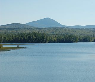
Mount Blue is a mountain in Maine, USA. It is a hiking destination with outstanding views from the observation deck of a tower at the summit. Its name is shared with Mount Blue State Park in Weld and Mount Blue High School in Farmington.

Mount Abraham is a mountain in the Green Mountains in the U.S. state of Vermont. Located in the Green Mountain National Forest, its summit is in the town of Lincoln in Addison County, but its eastern slopes extend into the town of Warren in Washington County. The mountain is named after Abraham Lincoln, former president of the United States. It is one of five peaks in Vermont's Presidential Range.

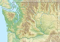
The Badger Mountain Centennial Preserve protects Badger Mountain, located on the edge of Richland in Washington, provides views of the Tri-Cities as well as the Columbia and Yakima rivers. Trails are open for hiking. No motorized vehicles are allowed.

Mount Le Conte is a mountain located within the Great Smoky Mountains National Park in Sevier County, Tennessee. At 6,593 ft (2,010 m) it is the third highest peak in the national park, behind Clingmans Dome and Mount Guyot. It is also the highest peak that is completely within Tennessee. From its immediate base to its summit, Mount Le Conte is the mountain with the highest relief east of the Rocky Mountains, rising 5,301 ft (1,616 m) from its base, near Gatlinburg, Tennessee.
Clearwater Wilderness is a 14,647-acre (5,927 ha) wilderness area in the North Cascades mountain range, in northern Washington state, of the Northwestern United States. It is located in the Mount Baker-Snoqualmie National Forest, southeast of Tacoma in northeastern Pierce County.

Chimney Tops is a mountain in the central Great Smoky Mountains in Tennessee. It is 4,724 feet (1,440 m) above sea level. Chimney Tops is a double-capstone knob on the eastern slope of the Sugarland Mountain massif, which stretches north-south across the north-central section of the Smokies. Mount Le Conte resides east of Chimney Tops and Mt. Mingus southeast of Chimney Tops. Thus, while the view from the summit is 360 degrees, Chimney Tops is practically "walled in" on three sides.

Big Schloss is a peak in the Great North Mountain range of the Ridge and Valley Appalachians, with an elevation of 2,964 feet (903 m). The peak is located in George Washington National Forest on the border of Virginia and West Virginia, though according to Topozone, the actual summit is in Virginia. The trail is part of the Lee Ranger District. It features a rocky outcropping of white sandstone with expansive views into Trout Run Valley in West Virginia and Little Schloss Mountain in Virginia.

Badger Mountain is a small mountain in Richland, Washington. Badger rises above the Tri-Cities connected to the smaller Candy Mountain via Goose Gap, is visible throughout much of the area and is a popular hiking destination for a wide variety of climbers. There are a number of trails climbing the mountain with varying levels of difficulty. Most of Badger Mountain is protected by the Badger Mountain Centennial Preserve, but the radio towers at the peak are private property. There are two summits on Badger Mountain, named the East Summit and the West Summit. The West Summit is the highest.

Goose Gap is a small pass connecting Badger Mountain to Candy Mountain to the west of Richland, Washington. It lies significantly higher than most of the Tri-Cities and is crossed by Interstate 182 just after its western terminus. An average of 18,000 people cross Goose Gap daily.

The Mount Adams Recreation Area is a 21,000-acre (8,500 ha) recreation area in the U.S. state of Washington managed by the Yakama Nation Tribal Forestry Program. The area encompasses an ecologically complex and geologically active landscape. The region features the most rugged side of Mount Adams, including canyons and the Great Gap section of the Mount Adams circumnavigation route, a three-mile trail-less section over two great canyons and many difficult glacial creeks. At 12,276 feet (3,742 m), Mount Adams is one of the major Cascade mountains. The recreation area is on the east side of the mountain and is part of the Yakama Indian Reservation and includes the popular Bird Creek Meadows area.

Crane Mountain is in the Warner Mountain range and is the tallest peak in Lake County, Oregon, U.S. It is located southeast of Lakeview in south-central Oregon, near the northwest corner of the Basin and Range Province of the western United States. The mountain is in the Fremont section of the Fremont–Winema National Forest. There was a United States Forest Service fire lookout located near the summit which was removed in 1972. The Crane Mountain National Recreation Trail runs north and south along the crest of the mountain.

The Cline Buttes are mountains with volcanic origins that form three dome-shaped peaks located in Deschutes County in central Oregon. They are some of the eastern foothills of the Cascade Range. Situated on land administered by the Bureau of Land Management, the buttes are flanked on the east and west sides by two separate sections of the Eagle Crest Resort. On the highest summit, there is a Federal Aviation Administration site with an aircraft navigation beacon. The mountains have several hiking trails as well as a number of popular mountain bike routes.

Jump off Joe is a butte in the Horse Heaven Hills south of Kennewick in the U.S. state of Washington. Jump off Joe rises above the Tri-Cities and is visible throughout much of the region, including in parts of Umatilla and Morrow Counties in Oregon to the south. A gravel road approaches the summit from the south up a steep incline. On a clear day, visitors to the summit can see Mount Hood, Mount Adams and Mount Rainier.