Satsop Hills

Last updated
Satsop Hills
BURNED CLEAR-CUT AREA ON THE PEAK SOUTH OF DUSK POINT IN OLYMPIC NATIONAL TIMBERLAND, WASHINGTON. NEAR OLYMPIC... - NARA - 555087.jpg
Logged hill, foreground, and peaks rising above fog in Satsop Hills
Highest point
PeakRock Peak
Elevation 3,294 ft (1,004 m) [1]
Coordinates 47°24′17″N123°22′54″W / 47.40472°N 123.38167°W / 47.40472; -123.38167
Geography
USA Washington relief location map.jpg
Red triangle with thick white border.svg
Location of the Satsop Hills
CountryUnited States
State Washington
Region Western Washington
Range coordinates 47°22′N123°27′W / 47.367°N 123.450°W / 47.367; -123.450
Parent range Olympic Mountains

The Satsop Hills are foothills of the Olympic Mountains in Mason County, Washington north of Matlock, Washington, between Wynoochee Lake to the west and Lake Cushman to the east. [2]

Contents

Geography

Inset map showing Satsop Hills in context of the Olympic Peninsula. Map by Erwin Raisz in 1941, predating creation of Wynoochee Dam and lake. Satsop Hills inset map.png
Inset map showing Satsop Hills in context of the Olympic Peninsula. Map by Erwin Raisz in 1941, predating creation of Wynoochee Dam and lake.

The Satsop River, with a 300-square-mile (780 km2) watershed, rises in the hills and flows south to the Chehalis River. [3] Where the river rises, 160 inches (4,100 mm) of annual precipitation qualifies as a temperate rainforest, a term used applied to the Satsop watershed by some publications. [3] [4] [5] The Wynoochee Oxbow meteorological station on the west end of the hills ( 47°17′57″N123°39′07″W / 47.29917°N 123.65194°W / 47.29917; -123.65194 (Wynoochee Oxbow) ) has both the highest average annual rainfall and the second highest ever recorded in the continental United States. [6] [7] The hills lie partly in the Olympic National Forest but not quite in the Olympic National Park. In a 1916 geological survey, hills in the vicinity of Matlock were included with the Black Hills of Thurston County, but may have been describing formations on the East Fork of the Satsop, to the south of the area described above. [lower-alpha 1] [9]

Peaks

Map this section's coordinates using: OpenStreetMap

Peaks in the Satsop Hills include: [10]

NameHeightLocationFire lookout?
Dusk Point3201 feet 47°24′40″N123°28′08″W / 47.411°N 123.469°W / 47.411; -123.469 (Dusk Point) Yes [11]
Grisdale Hill1446 feet 47°22′23″N123°17′56″W / 47.373°N 123.299°W / 47.373; -123.299 (Grisdale Hill) 1940s [12]
Rock Peak3294 feet [1] 47°24′17″N123°22′54″W / 47.40472°N 123.38167°W / 47.40472; -123.38167 (Rock Peak)
South Mountain2903 feet 47°18′43″N123°22′16″W / 47.312°N 123.371°W / 47.312; -123.371 (South Mountain) 1956–1976 [13]

History

Forest fires have struck the hills repeatedly. The term "Satsop hills" has been used at least since 1885 when the Morning Oregonian used it to describe the location of forest fires. [lower-alpha 2]

In September, 1902, "catastrophic" fires burned across Southwest Washington, including a burn from Elma to Shelton on Puget Sound that destroyed one million board feet of lumber at a mill in the hills above Elma, and uncounted volumes of live trees. On September 12, the county seat, Montesano experienced darkness at noon. A one- to two-mile wide swath of timber was completely burned from Elma to Summit Lake, 13 miles west. [15]

Several fire lookouts were built on peaks in the 20th century as listed above as part of a national effort to control fires.

Fugitive John Tornow

The hills were the hideout of John Tornow, a fugitive who lived in the hills for 19 months in the 1910s. He was accused of murdering several people including two nephews, and was eventually found and killed there by the then Chehalis County sheriff's deputy in 1913. [16] [17] [lower-alpha 3]

Transportation

The hills are crossed by extensive logging roads and an abandoned logging railroad formerly operated by Simpson Timber Company. [19] [20] The Vance Creek Bridge, 347 feet (106 m) [21] above Vance Creek ( 47°20′04″N123°19′17″W / 47.33444°N 123.32139°W / 47.33444; -123.32139 ), was the highest railroad bridge in the United States and remains among the twenty highest bridges in the country. [22]

Wildlife

Deer and Roosevelt Elk herds are in the hills, as well as black bear, cougars and game birds including grouse and "the largest population of mountain quail in the state". Elk are probably migratory and move in and out of the Olympic National Park. [lower-alpha 4] [24]

Sasquatch are reported to live in the hills, with 22 reported sightings as of 2014, [25] including a case discovered by a sheriff's deputy in 1982 and investigated by an Idaho State University biologist in 2004. [26]

Recreation

Satsop River west fork WEST FORK OF THE SATSOP RIVER IN OLYMPIC NATIONAL TIMBERLAND, WASHINGTON. NEAR OLYMPIC NATIONAL PARK - NARA - 555218.jpg
Satsop River west fork

Recreation in the hills includes canoeing and kayaking, camping, fishing, hunting and hiking. [23] [27] [28] [29] [30] Schafer State Park, part of the Washington State Parks system, is on the Satsop River in the low hills at an altitude of 125 feet (38 m); [31] Truman Glick County Park (35 acres (14 ha)) is along the abandoned railroad on the southern side of the hills. [19] [32] Hiking destinations noted in printed and online guides include Satsop Lakes ( 47°25′25″N123°30′37″W / 47.42361°N 123.51028°W / 47.42361; -123.51028 ), [28] Spoon Creek Falls, [33] [34] South Mountain, a 3,044-foot (928 m) "moderately well known winter hiking destination" in Mason County, [35] [36] and Vance Creek Bridge, "made famous from millions of Instagram, Facebook, Tumblr and Twitter images" and though on closed private land, was "one of the more popular destinations on the Olympic Peninsula". [20]

The Grays Harbor County high point is a 4,880-foot (1,490 m) peak near a slightly higher peak in Mason County unofficially named Wynoochee Point, sought by highpointing enthusiasts; it is on the Grays Harbor–Mason County line in the Satsop Hills or nearby in the adjacent Wynoochee watershed ( 47°29′42″N123°30′22″W / 47.49500°N 123.50611°W / 47.49500; -123.50611 ). [37] [38] [39]

Footnotes

  1. "The north limits [of the Black Hills] would then extend as far as Hoodsport on Hood Canal. The western limits would extend from Hoodsport southwesterly to Matlock and thence to McCleary ... [I]n the vicinity of Matlock they form a low divide between the Puget Sound basin and Grays Harbor. From Matlock the elevation of this divide gradually increases and soon merges into a high rugged spur of the Olympic Mountains..." [8]
  2. "Heavy fires are raging in Mason County. At Shelton's Point the loggers are fighting it. Opposite that point Willey has had to remove his camp. Men are on watch along the Satsop railroad to prevent the fire from burning the logs, of which there are several hundred thousand feet. On the Satsop hills heavy fires are running, and large numbers of elk have been driven down in consequence." (emphasis added) [14]
  3. "two quick shots slammed through the Satsop hills and the two boys were dead" [18]
  4. "Elk in GMU 636 can primarily be found in the upper Wynoochee River valley, the Skokomish River valley, and near the town of Matlock, WA. Although some herds remain non-migratory, we have documented migratory movement from the upper Wynoochee to the Olympic National Parkand the North Fork Skokomish River at Lake Cushman, as well as movement up the South Fork Skokomish river valley into the Olympic National Park." [23]

Related Research Articles

<span class="mw-page-title-main">Grays Harbor County, Washington</span> County in Washington, United States

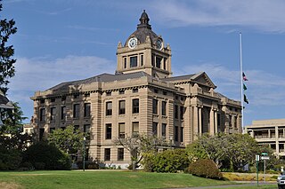
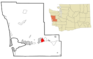
Grays Harbor County is a county in the U.S. state of Washington. As of the 2020 census, the population was 75,636. Its county seat is Montesano, and its largest city is Aberdeen. Grays Harbor County is included in the Aberdeen Micropolitan Statistical Area.

<span class="mw-page-title-main">Brady, Washington</span> Census-designated place in Washington, United States

Brady is a census-designated place (CDP) in Grays Harbor County, Washington, United States. The population was 676 at the 2010 census.

<span class="mw-page-title-main">Moclips, Washington</span> Census-designated place in Washington, United States

Moclips is an unincorporated community and census-designated place (CDP) in Grays Harbor County, Washington, United States. The population was 207 at the 2010 census. It is located near the mouth of the Moclips River.

<span class="mw-page-title-main">Satsop, Washington</span> Census-designated place in Washington, United States

Satsop is a census-designated place (CDP) in Grays Harbor County, Washington, United States. The population was 675 at the 2010 census, up from 619 at the 2000 census.

<span class="mw-page-title-main">Olympic Mountains</span> Mountain range in Washington, United States

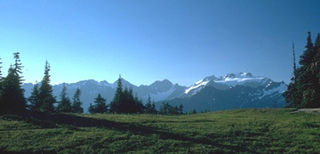
The Olympic Mountains are a mountain range on the Olympic Peninsula of the Pacific Northwest of the United States. The mountains, part of the Pacific Coast Ranges, are not especially high – Mount Olympus is the highest summit at 7,980 ft (2,432 m); however, the eastern slopes rise precipitously out of Puget Sound from sea level, and the western slopes are separated from the Pacific Ocean by the low-lying 20 to 35 km wide Pacific Ocean coastal plain. These densely forested western slopes are the wettest place in the 48 contiguous states. Most of the mountains are protected within the bounds of Olympic National Park and adjoining segments of the Olympic National Forest.

<span class="mw-page-title-main">Chehalis River (Washington)</span> River in Washington state, United States

The Chehalis River is a river in Washington in the United States. It originates in several forks in southwestern Washington, flows east, then north, then west, in a large curve, before emptying into Grays Harbor, an estuary of the Pacific Ocean. The river is the largest solely contained drainage basin in the state.

<span class="mw-page-title-main">Chehalis people</span>

The Chehalis people or Tsihalis are a native people of western Washington state in the United States. They should not be confused with the similarly named Chehalis First Nation of the Sts'Ailes people along the Harrison River in the Fraser Valley area of British Columbia.

<span class="mw-page-title-main">Skokomish people</span> North American tribe

The Skokomish are one of nine tribes of the Twana, a Native American people of western Washington state in the United States. The tribe lives along Hood Canal, a fjord-like inlet on the west side of the Kitsap Peninsula and the Puget Sound basin. Historically the Twana were hunters, fishers, and gatherers who had a nomadic lifestyle during the warmer months, while living in more permanent homes during the winter months.

<span class="mw-page-title-main">Olympic Peninsula</span> Peninsula in Washington, United States

The Olympic Peninsula is a large arm of land in western Washington that lies across Puget Sound from Seattle, and contains Olympic National Park. It is bounded on the west by the Pacific Ocean, the north by the Strait of Juan de Fuca, and the east by Hood Canal. Cape Alava, the westernmost point in the contiguous United States, and Cape Flattery, the northwesternmost point, are on the peninsula. Comprising about 3,600 square miles (9,300 km2), the Olympic Peninsula contained many of the last unexplored places in the contiguous United States. It remained largely unmapped until Arthur Dodwell and Theodore Rixon mapped most of its topography and timber resources between 1898 and 1900.

Olympic National Forest is a U.S. National Forest located in Washington, USA. With an area of 628,115 acres (2,541.89 km2), it nearly surrounds Olympic National Park and the Olympic Mountain range. Olympic National Forest contains parts of Clallam, Grays Harbor, Jefferson, and Mason counties. The landscape of the national forest varies, from the temperate Olympic rain forest to the salt water fjord of Hood Canal to the peaks of Mt. Washington.

The Wynoochee River is a 60-mile (97 km) long river located in the Olympic Peninsula in the U.S. state of Washington. A tributary of the Chehalis River, the Wynoochee River rises in the Olympic Mountains within the Olympic National Park and flows generally south. Its drainage basin is 218 square miles (560 km2) in area. The name Wynoochee comes from the Lower Chehalis placename /xʷənúɬč/, meaning "shifting".

<span class="mw-page-title-main">Skokomish River</span> River in the United States

The Skokomish River is a river in Mason County, Washington, United States. It is the largest river flowing into Hood Canal, a western arm of Puget Sound. From its source at the confluence of the North and South Forks the main stem Skokomish River is approximately 9 miles (14 km) long. The longer South Fork Skokomish River is 40 miles (64 km), making the length of the whole river via its longest tributary about 49 miles (79 km). The North Fork Skokomish River is approximately 34 miles (55 km) long. A significant part of the Skokomish River's watershed is within Olympic National Forest and Olympic National Park.

<span class="mw-page-title-main">WNP-3 and WNP-5</span>

Washington Nuclear Project Nos. 3 and 5, abbreviated as WNP-3 and WNP-5 were two of the five nuclear power plants on which construction was started by the Washington Public Power Supply System in order to meet projected electricity demand in the Pacific Northwest. WNP-1, WNP-2 and WNP-3 were part of the original 1968 plan, with WNP-4 and WNP-5 added in the early 1970s.

<span class="mw-page-title-main">Satsop River</span> River in Washington, United States

The Satsop River is a stream in the U.S. state of Washington. It has three main tributary forks, the East Fork, West Fork, and Middle Fork Satsop Rivers. The main stem Satsop River is formed by the confluence of the West and East Forks. The Middle Fork is a tributary of the East Fork. The three forks are much longer than the main stem Satsop itself, which flows south from the confluence only a few miles to join the Chehalis River near Satsop, Washington. Other significant tributaries include the Canyon River and Little River, both tributaries of the West Fork Satsop, and Decker Creek, a tributary of the East Fork Satsop River. The Satsop River's major tributaries originate in the Olympic Mountains and its southern foothills, the Satsop Hills, within Grays Harbor and Mason counties. Most of the Satsop River's watershed consists of heavily wooded hill lands. The upper tributaries extend into Olympic National Forest, approaching but not quite reaching Olympic National Park.

The Blue Hills just west of Bremerton, Washington, also called the Bremerton Hills, Bald Hills, and Wildcat Hills, consist of Gold Mountain, Green Mountain, and several informally named hills. Reaching an elevation of 1761 feet, a thousand feet above the glacial till that fills the Puget Lowland, they form a prominent landmark visible around the region. They are formed of uplifted blocks of marine basalts, the steep-walled canyons between the various summits being the fissures between the blocks. In addition to Gold Mountain and Green Mountain are several other prominent peaks unofficially named according to their elevation :

<span class="mw-page-title-main">Chehalis Gap</span> Gap in the Coast Range, Washington

The Chehalis Gap is a gap in the Coast Range of Washington state between the southernmost foothills of the Olympic Mountains called the Satsop Hills, and the Willapa Hills.

Lake Nahwatzel is a body of freshwater located in Mason County in the U.S. state of Washington. The lake is fed by three main sources, which include two unnamed creeks and naturally occurring hot springs. The lake empties into the East Fork of the Satsop River via Outlet Creek. Lake Nahwatzel is one of the warmest lakes in western Washington due to the presence of the aforementioned hot springs. Nearby towns include Shelton and Matlock.

<span class="mw-page-title-main">Grays Harbor Transit</span>

The Grays Harbor Transportation Authority, doing business as Grays Harbor Transit, is a public transit agency serving Grays Harbor County in the U.S. state of Washington. It operates ten fixed bus routes traveling through the county's major cities and connecting to Olympia in Thurston County and Centralia in Lewis County, as well as paratransit service, dial-a-ride routes and a vanpool fleet. The agency, one of the first county transit authorities to be established in Washington state, began operations on June 16, 1975, and is one of few in the state that are not governed as a public transportation benefit area.

<span class="mw-page-title-main">Quillehuyte County, Washington</span>

Quillehuyte County was a Washington Territory county from January 29, 1868, to 1869. It and Ferguson County are the only two counties of the territory that dissolved, although the Washington Territorial Legislature attempted to dissolve Skamania County in January 1865, but was overruled by the United States Congress. Additionally, some Washington counties have been renamed since their formation; Sawamish County was renamed to Mason in 1864 for example.

References

Notes
  1. 1 2 U.S. Geological Survey Geographic Names Information System: Rock Peak
  2. 1 2 Raisz 1989.
  3. 1 2 Smith & Wenger 2001, p. 43.
  4. Landers 2008, p. 161.
  5. Alaska Coastal Rainforest Center 2013, p. 1.
  6. Ahrens 2008, p. 357.
  7. NOAA 1999.
  8. Weaver 1916, p. 137.
  9. Schuster 2005.
  10. Topographic Map Summit Features in Mason County, Washington, TopoZone
  11. "Dusk Peak Fire Lookout".
  12. "Grisdale Hill Fire Lookout Tower".
  13. "South MTN. Fire Lookout Cabin".
  14. Morning Oregonian 1885.
  15. Tacoma Public Library 2004.
  16. Gibson 2001, p. 36 he lived on "a homestead on the upper Satsop River"
  17. Lindstrom 2014.
  18. Van Syckle 1982.
  19. 1 2 Hawthorn 2003.
  20. 1 2 Milliman 2014.
  21. "Vance Creek Bridge". HighestBridges.com. Eric Sakowski. 10 December 2009. Archived from the original on 12 September 2016. Retrieved 1 November 2016.
  22. Marshall 1981.
  23. 1 2 WDFW 2014.
  24. Beerbower 2014.
  25. Grays Harbor Tourism 2014.
  26. Meldrum 2004.
  27. Landers 2008, pp. 159–163.
  28. 1 2 US Forest Service 2014.
  29. Washington State Parks 2009.
  30. Smith & Wenger 2001, p. 29.
  31. "Schafer State Park". Geographic Names Information System . United States Geological Survey, United States Department of the Interior . Retrieved 2014-11-03.
  32. Mason County Parks 2014.
  33. Romano 2007, p. 114.
  34. Wood 2010, p. 242.
  35. "South Mountain". SummitPost.org. Summitpost.org. Retrieved 2014-11-03.
  36. "South Mountain". Peakbagger.com. Retrieved 2014-11-03.
  37. Roper 1994.
  38. Slayden 2004.
  39. Wolcott 1961.
Sources