The Tri-Cities are three closely linked cities at the confluence of the Yakima, Snake, and Columbia Rivers in the U.S. state of Washington. Located in the Columbia Basin of Eastern Washington, the cities border one another, making the Tri-Cities seem like one uninterrupted mid-sized city. The three cities function as the center of the Tri-Cities metropolitan area, which consists of Benton and Franklin counties. The Tri-Cities urban area includes the city of West Richland, the census-designated places (CDP) of West Pasco and Finley, as well as the CDP of Burbank, despite the latter being located in Walla Walla County.
Kennewick is a city in Benton County in the U.S. state of Washington. It is located along the southwest bank of the Columbia River, just southeast of the confluence of the Columbia and Yakima rivers and across from the confluence of the Columbia and Snake rivers. It is the most populous of the three cities collectively referred to as the Tri-Cities. The United States Census Bureau estimated the population to be 85,158 as of 2023, up from 83,921 at the 2020 United States census.
The Inland Northwest, historically and alternatively known as the Inland Empire, is a region of the American Northwest centered on the Greater Spokane, Washington Area, encompassing all of Eastern Washington and North Idaho. Under broader definitions, Northeastern Oregon and Western Montana may be included in the Inland Northwest. Alternatively, stricter definitions may exclude Central Washington and Idaho County, Idaho.

KAPP is a television station in Yakima, Washington, United States, affiliated with ABC and owned by Morgan Murphy Media. The station's studios are located in the Liberty Building on North 3rd Street in downtown Yakima, and its transmitter is located on Ahtanum Ridge.

KEPR-TV is a television station licensed to Pasco, Washington, United States, serving the Tri-Cities area as an affiliate of CBS and The CW Plus. Owned by Sinclair Broadcast Group, the station maintains studios on West Lewis Street in Pasco and a transmitter on Johnson Butte near Kennewick.
KWSU-TV is a PBS member television station licensed to Pullman, Washington, United States. The station is owned by Washington State University. KWSU-TV's studios are located in the Murrow Communications Center on WSU's main campus in Pullman, and its transmitter is located on Kamiak Butte near Palouse, Washington.

KFFX-TV is a television station licensed to Pendleton, Oregon, United States, serving the Tri-Cities, Washington area as an affiliate of Fox and Telemundo. It is the only major commercial station in the Tri-Cities area that is licensed to the Oregon side of the market. Owned by Imagicomm Communications, KFFX-TV has studios on Clearwater Avenue in Kennewick, Washington, and its transmitter is located in the Umatilla National Forest east of Pendleton.
KNDO is a television station in Yakima, Washington, United States, affiliated with NBC. It is owned by the Spokane-based Cowles Company as part of the KHQ Television Group. KNDO's studios are located on West Yakima Avenue in downtown Yakima, and its transmitter is located on Ahtanum Ridge.
KTNW is a PBS member television station in Richland, Washington, United States, serving the Tri-Cities area. The station is owned by Washington State University (WSU) and is part of its Northwest Public Broadcasting group of radio and television services. KTNW's studios are located on the WSU Tri-Cities campus in Richland, and its transmitter is located on Jump Off Joe Butte. Master control and most internal operations are based at the studios of sister station KWSU-TV in the Murrow Communications Center on WSU's main campus in Pullman.

Gesa Stadium is a Minor League Baseball park in the northwest United States, located in Pasco, Washington. Opened 29 years ago in 1995, it is the home field of the Tri-City Dust Devils of the Northwest League.
KUJ-FM is a commercial radio station licensed to Burbank, Washington, and serving the Tri-Cities area. It airs a Top 40 (CHR) radio format. Weeknights it carries the syndicated Tino Cochino Radio Show and on weekends it airs American Top 40 with Ryan Seacrest. It is owned by Stephens Media Group, with studios on West 24th Avenue in Kennewick.

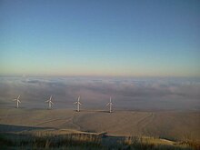
The Horse Heaven Hills are a long range of high, rolling hills in Klickitat, Yakima, and Benton counties in Washington. The hills are an anticline ridge in the Yakima Fold Belt formed by north–south compression of lava flows in the Columbia River Basalt Group. The highest point is Bickleton Ridge in the west end of the hills. They lie within the rain shadow to the east of the Cascade Range, making them significantly drier and hotter than regions west of the Cascades.
KKSR is a radio station licensed to Walla Walla, Washington, serving the Tri-Cities area. The station is currently owned by SMG - Tri-Cities, LLC.
KORD-FM is a radio station broadcasting a country music format. Licensed to Richland, Washington, United States, the station serves the Tri-Cities area. The station is currently owned by Townsquare Media and features programming from Compass Media Networks. The transmitter is located on Jump Off Joe.
KEGX is a radio station broadcasting a Classic rock format. Licensed to Richland, Washington, United States, the station serves the Tri-Cities area. In 2018, KEGX became part of Stephens Media Group.
KALE is a radio station licensed to Richland, Washington, United States, the station serves the Tri-Cities, Washington area. The station is owned by Stephens Media Group.

The Olympic–Wallowa lineament (OWL) is a series of geologic structures oriented from northwest to southeast for 650 km (400 mi) across Washington and northeast Oregon in the United States, passing through the Seattle area and including notable features east of the Cascade Range such as the Yakima Fold Belt and Wallowa Mountains. It was first reported by cartographer Erwin Raisz in 1945 on a relief map of the continental United States. Some geologists have questioned the existence of a geological relationship between the individual structures along the lineament suggesting it is an optical illusion. The origin of this feature in its entirety is not well understood with multiple hypotheses on the subject. The Olympic–Wallowa lineament likely predates the Columbia River Basalt Group.

The Brothers Fault Zone (BFZ) is the most notable of a set of northwest-trending fault zones including the Eugene–Denio, McLoughlin, and Vale zones that dominate the geological structure of most of Oregon. These are also representative of a regional pattern of generally northwest-striking geological features ranging from Walker Lane on the California–Nevada border to the Olympic–Wallowa Lineament in Washington; these are generally associated with the regional extension and faulting of the Basin and Range Province, of which the BFZ is considered the northern boundary.
The Yakima Fold Belt of south-central Washington, also called the Yakima fold-and-thrust belt, is an area of topographical folds raised by tectonic compression. It is a 14,000 km2 (5,400 sq mi) structural-tectonic sub province of the western Columbia Plateau Province resulting from complex and poorly understood regional tectonics. The folds are associated with geological faults whose seismic risk is of particular concern to the nuclear facilities at the Hanford Nuclear Reservation and major dams on the Columbia and Snake Rivers.

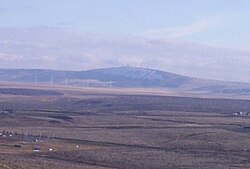
Badger Mountain is a small mountain in Richland, Washington. Badger rises above the Tri-Cities connected to the smaller Candy Mountain via Goose Gap, is visible throughout much of the area and is a popular hiking destination for a wide variety of climbers. There are a number of trails climbing the mountain with varying levels of difficulty. There are two summits on Badger Mountain, named the East Summit and the West Summit. The West Summit is the highest.