List of mountains and hills of Kitsap County, Washington

Last updated
Map all coordinates using: OpenStreetMap  
Download coordinates as: KML

This is a list of mountains and hills of Kitsap County, Washington by elevation.

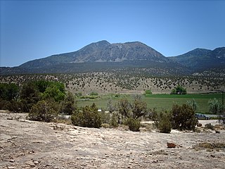
The county's highest peaks are in the Blue Hills, in the Wildcat Lake or Bremerton West USGS quadrangle. Inclusion is defined here as within 2 miles of Green Mountain or Gold Mountain, as the boundaries are not strictly defined by authorities.

RankNameRange Elevation (ft) Prominence (ft)Parent (proximate) Isolation (mi)CoordinatesNotes
1 Gold Mountain Blue Hills17611531 Olympic Mountains foothills
 Green Hill, Jefferson County
13.24 47°32′56″N122°47′13″W / 47.54889°N 122.78694°W / 47.54889; -122.78694 (Gold Mountain) Kitsap County high point
2 Green Mountain Blue Hills1710860Gold Mountain1.35 47°33′48″N122°48′25″W / 47.56333°N 122.80694°W / 47.56333; -122.80694 (Green Mountain)
3Kitsap LookoutBlue Hills1370600Gold Mountain1.92 47°32′38″N122°44′46″W / 47.54389°N 122.74611°W / 47.54389; -122.74611 (Kitsap Lookout) Unnamed at Lists of John, named at Peakbagger [1]
4Peak 1330Blue Hills1330480Gold Mountain1.67 47°34′09″N122°46′04″W / 47.56917°N 122.76778°W / 47.56917; -122.76778 (Peak 1330) Listed as Peak 1320 at Peakbagger
5Peak 1291Blue Hills1291401Green Mountain1.95 47°35′21″N122°48′00″W / 47.58917°N 122.80000°W / 47.58917; -122.80000 (Peak 1291)
6Peak 1107Blue Hills1107317Peak 12910.86 47°35′14″N122°49′06″W / 47.5872°N 122.8183°W / 47.5872; -122.8183 (Peak 1107)
7Peak 955Blue Hills955305Green Mountain1.33 47°33′03″N122°49′56″W / 47.5508°N 122.8322°W / 47.5508; -122.8322 (Peak 955) At south end of Lake Tahuya
8Peak 730Blue Hills730480Kitsap Lookout1.95 47°32′53″N122°42′18″W / 47.54806°N 122.70500°W / 47.54806; -122.70500 (Peak 730) Inside Bremerton city limits
Listed as Peak 720 at Peakbagger
9Unnamed hill (Apex Airport hill)525 [2] [3] 47°39′24″N122°44′00″W / 47.65667°N 122.73333°W / 47.65667; -122.73333 (Apex Airport hill) 2 miles west of Silverdale
10Peak 510 (or Peak 500)510 [4] 3406.07 47°49′08″N122°36′42″W / 47.8190°N 122.6118°W / 47.8190; -122.6118 (Peak 510) 1.5 miles east of Kitsap Memorial State Park; northernmost 500-foot elevation in the county [5]
10Unnamed hillc. 510 [6] 47°48′04″N122°36′51″W / 47.80122°N 122.61409°W / 47.80122; -122.61409 (Unnamed hill) USGS topographic quad shows 500-foot contour approx. 1.5 mi. east of Breidablick
12Peak 490490380Peak 7305.55 47°36′10″N122°37′04″W / 47.6027°N 122.6179°W / 47.6027; -122.6179 (Peak 490) Near Illahee Preserve
13Sawmill Lookout460 [7] 260Peak 500 (510)3.7 47°45′48″N122°35′17″W / 47.76333°N 122.58806°W / 47.76333; -122.58806 (Sawmill lookout) 2.75 miles northeast of Poulsbo
14Peak 450450300 Vashon Island high point3.88 47°29′32″N122°32′57″W / 47.4923°N 122.5492°W / 47.4923; -122.5492 (Peak 450) Near Banner Forest Park
15Kingston View Point440 [8] 340Peak 5104.81 47°49′12″N122°30′30″W / 47.8200°N 122.5083°W / 47.8200; -122.5083 (Kingston View Point) Above Kingston ferry terminal. Listed as 450 ft. at Lists of John. [9]
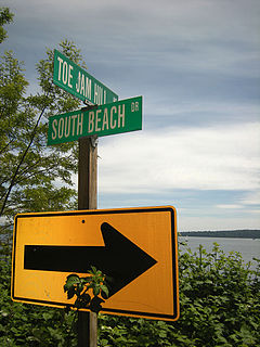
16 Toe Jam Hill * Bainbridge Island 425425Peak 4906.66 47°35′03″N122°30′08″W / 47.58417°N 122.50222°W / 47.58417; -122.50222 (Toe Jam Hill) Bainbridge Island high point
17Peak 410410380Peak 4504.10 47°45′39″N122°30′40″W / 47.7607°N 122.5112°W / 47.7607; -122.5112 (Peak 410) Inside Port Madison Indian Reservation
*The Bainbridge Island high point's location is reported variously. Lists of John gives Gazzam Lake Hill based on USGS topographic maps, which used stereoscopic aerial surveys. Peakbagger gives Toe Jam Hill at 15 feet higher or more, based on newer high-resolution LIDAR maps. [10]
Gold Mountain from Eastside.jpg
Blue Hills from the east: Kitsap Lookout, Gold Mountain and Green Mountain left to right

Related Research Articles

Ute Mountain

Ute Mountain, also known as Ute Peak or Sleeping Ute Mountain, is a peak within the Ute Mountains, a small mountain range in the southwestern corner of Colorado. It is on the northern edge of the Ute Mountain Ute Tribe Reservation. The Reservation forms the southwestern corner of the state and of Montezuma County.

Rattlesnake Hills

The Rattlesnake Hills, also known as Rattlesnake Ridge, is a 16-mile (26 km) long anticline mountain ridge in Yakima County and Benton County in the U.S. state of Washington. It should not be confused with the much smaller Rattlesnake Ridge located near the west end of Ahtanum Ridge. The highest point in the hills is the 3,629 feet (1,106 m) Lookout Summit, which surpasses the more well-known Rattlesnake Mountain by approximately 100 ft. The Rattlesnake Hills are part of the Yakima Fold Belt of east-tending long ridges formed by the folding of Miocene Columbia River basalt flows.

Buckner Mountain

Buckner Mountain is a tall peak in the North Cascades of Washington state and in the Stephen Mather Wilderness of North Cascades National Park. At 9,114 feet (2,778 m) in elevation it is the highest in Skagit County and one of about ten of Washington's non-volcanic peaks above 9,000 feet high. It is ranked as the 14th highest peak in the state, and the third highest peak in North Cascades National Park.

Blue Hills (Washington) Series of hills in Washington, United States

The Blue Hills just west of Bremerton, Washington, also called the Bremerton Hills, Bald Hills, and Wildcat Hills, consist of Gold Mountain, Green Mountain, and several informally named hills. Reaching an elevation of 1761 feet, a thousand feet above the glacial till that fills the Puget Lowland, they form a prominent landmark visible around the region. They are formed of uplifted blocks of marine basalts, the steep-walled canyons between the various summits being the fissures between the blocks. In addition to Gold Mountain and Green Mountain are several other prominent peaks unofficially named according to their elevation :

Toe Jam Hill

Toe Jam Hill, 425 feet tall, is the high point on Bainbridge Island, Washington and one of the highest points in Kitsap County, Washington.

Satsop Hills

The Satsop Hills are foothills of the Olympic Mountains in Mason County, Washington north of Matlock, Washington, between Wynoochee Lake to the west and Lake Cushman to the east.

Doty Hills

The Doty Hills are hills in Lewis County and Grays Harbor County in southwest Washington. The hills lie north of Doty, Washington and west of Chehalis, between the Black Hills to their north and the Willapa Hills to their south. They are considered part of the Willapa Hills physiographic province.

Hills in the Puget Lowland, between the Cascades and the Olympic Mountains, including the entire Seattle metropolitan area, are generally between 350–450 feet (110–140 m) and rarely more than 500 feet (150 m) above sea level. Hills are often notable geologically and for social reasons, such as the seven hills of Seattle.

Lookout Summit

Lookout Summit—officially listed as "Lookout" in the Geographic Names Information System—is the highest point in Benton County, in the U.S. state of Washington. The mountain is also the highest point in the Rattlesnake Hills, with an elevation 98 ft higher than the neighboring, more-well-known Rattlesnake Mountain—which is the second highest peak in the range.

Mountain peaks of Virginia

This article comprises three sortable tables of the major mountain peaks of Virginia. This article defines a significant summit as a summit with at least 100 meters of topographic prominence, and a major summit as a summit with at least 500 meters of topographic prominence. All summits in this article have at least 500 meters of topographic prominence. An ultra-prominent summit is a summit with at least 1500 meters of topographic prominence.

Old Baldy Mountain (Okanogan County, Washington)

Old Baldy Mountain is a peak in the Okanogan-Wenatchee National Forest, in Okanogan County, Washington, 10 miles northwest of Conconully. The height is listed at modern sources as 7,844 ft or 7,849 ft or 7,854 ft. Older government maps showed 7,870 feet elevation. There is a geodetic survey benchmark at 7,848 ft near the summit. Some sources show the mountain in the Okanogan Range.

References

  1. Greg Slayden (2004), Kitsap Lookout, peakbagger.com
  2. U.S. Geological Survey Geographic Names Information System: Apex Airpark, Kitsap County, Washington
  3. Apex/8W5 (PDF) (Official airport reference guide), Washington State Department of Transportation, p. 110, retrieved 2019-01-16
  4. Peak 500, Peakbagger
  5. Kitsap County GIS.
  6. Port Gamble, WA topographic quad, United States Geological Survey
  7. Sawmill lookout site, Peakbagger
  8. Kingston View Point (provisional), Peakbagger
  9. Kirk 2020.
  10. Greg Slayden (2004), Toe Jam Hill, peakbagger.com

Sources