Garhwal is one of the two administrative divisions of the Indian state of Uttarakhand. Lying in the Himalayas, it is bounded on the north by Tibet, on the east by Kumaon, on the south by Uttar Pradesh state, and on the northwest by Himachal Pradesh state. It includes the districts of Chamoli, Dehradun, Haridwar, Pauri Garhwal, Rudraprayag, Tehri Garhwal, and Uttarkashi. The people of Garhwal are known as Garhwali and speak the Garhwali language. The administrative center for Garhwal division is the town of Pauri. The Divisional Commissioner is the administrative head of the Division, and is a senior Indian Administrative Service officer. As the administrative head of the division, the Commissioner is overall incharge of the 7 districts in the Garhwal region of Uttarakhand, and is aided in his duties by an additional commissioner and the district magistrates. Sushil Kumar is the divisional commissioner of the Garhwal Division since December 2021.
Joshimath, also known as Jyotirmath, is a town and a municipal board in Chamoli District in the Indian state of Uttarakhand. Located at a height of 6,150 feet, it is a gateway to several Himalayan mountain climbing expeditions, trekking trails and pilgrim centres like Badrinath. It is home to one of the four cardinal pīthas established by Adi Shankara.

The Alaknanda is a turbulent Himalayan river in the Indian state of Uttarakhand and one of the two headstreams of the Ganges, the major river of Northern India and a river considered holy in Hinduism. In hydrology, the Alaknanda is considered the source stream of the Ganges on account of its greater length and discharge; while, in Hindu tradition and culture, the other headstream, the Bhagirathi, is considered the source stream.
Paonta Sahib is an industrial town of Himachal Pradesh in India. It is located in the south of Sirmaur district, on National Highway 72. Paonta Sahib is an important place of worship for Sikhs, hosting a large Gurdwara named Gurudwara Paonta Sahib, on the banks of the river Yamuna. The river is the boundary between the states of Himachal Pradesh and Uttarakhand.

Gauchar is a Hill Town sort of a valley town located in Karnaprayag tehsil within Chamoli district of Uttarakhand state in India. Gauchar is situated on the left bank of river Alaknanda and is en route to the celebrated holy destination of Badrinath. It is well known for being one of the cleanest place in country. It has previously topped Swachta sarvekshan best ganga town award. Situated at an altitude of 800 metres (2,620 ft) above the sea level, Gauchar is surrounded by seven mountains. Gauchar is well known for its historic trade fair and airstrip. Gauchar town known for its great work to curb loss of lives in 2013 flood disaster of Uttarakhand. This town is unique in terms of its geographical location and topography. Gauchar is located on one of the largest pieces of flatland in this mountainous region of Uttarakhand. Education institution in Gauchar includes a beautiful Kendriya Vidyalaya adjacent to the main playground.

Karnaprayag is a town and municipal board in the Chamoli District in the Indian state of Uttarakhand. Karnaprayag is one of the Panch Prayag of Alaknanda River, situated at the confluence of the Alaknanda and Pindar River.

Naraingarh is a town, municipal committee and assembly constituency in the Ambala district of the Indian state of Haryana, located on the border with the Indian state of Himachal Pradesh. Due to its geographical location, the Naraingarh plays an important role in local tourism, being located 39 km from Ambala, the district headquarter, 52 km of Chandigarh, the state capital, 144 km of Shimla, and 230 km of New Delhi.

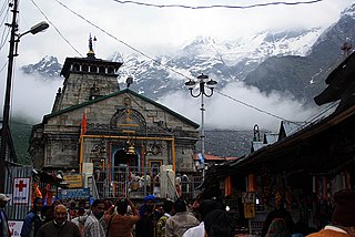
Rudraprayag is a city and a municipality in Rudraprayag district in the Indian state of Uttarakhand. Rudraprayag is one of the Panch Prayag of Alaknanda River, the point of confluence of rivers Alaknanda and Mandakini. Kedarnath, a Hindu holy city is located 86 km from Rudraprayag. The man-eating Leopard of Rudraprayag hunted and written about by Jim Corbett dwelled here.

The Doon Valley is an unusually wide, long valley within the Sivalik Hills and the Lesser Himalayas, in the Indian states of Uttarakhand, Himachal Pradesh and Haryana. Within the valley lies the city of Dehradun, the winter capital of Uttarakhand state.

This article is about the old number of Delhi-Meerut-Roorkee-Haridwar-Badrinath National Highway.
Chandrashila is the summit above Tungnath temple in India. It literally means "Moon Rock". It is located at a height of about 3,690 metres (12,110 ft) above sea level. This peak provides views of the Himalayas, including Nandadevi, Trisul, Kedar Peak, Bandarpunch and Chaukhamba peaks. There are various legends associated with this place. According to one such legend, this is where Lord Rama meditated after defeating the demon-king Ravana. Another legend says that the moon-god Chandra spent time here in penance.

National Highway 5 (NH5) is a primary national highway in India, running from West to East, connecting Firozpur in Punjab to the Sino-Indian border at Shipki La. The highway passes through Moga, Jagraon, Ludhiana, Mohali, Chandigarh, Panchkula, Kalka, Solan, Shimla, Theog, Narkanda, Kumarsain, Rampur Bushahr and continues along the Sutlej River till its terminus near the Tibet border.

National Highway 9 is a National Highway in India in east-west direction. It starts at Malout in Punjab and ends at Pithoragarh in Pithoragarh district in Uttarakhand. It passes through the states of Punjab, Haryana, Delhi, Uttar Pradesh and Uttarakhand. After renumbering of all national highways by National Highway Authority of India in 2010, the current NH 9 was formed by merging segments of five separate national highways in 2010; these were Old NH 10, Old NH 24, Old NH 87, Old NH 74 and Old NH 125.
National Highway 707 starts from Hatkoti and ends at Paonta Sahib, both places in the state of Himachal Pradesh. On its way to Paonta Sahib it travels through the Indian state of Uttarakhand. The highway is 151 km (94 mi) long. It passes through towns of Sataun, Kamrau, Kaffota, Chareu, Shillai, Shiri kyari, Rohnat in the state of Himachal Pradesh.

National Highway 907 is an Indian National Highway starts from Paonta Sahib, Himachal Pradesh and ends at Yamuna Nagar, Haryana. The highway is 57 km (35 mi) long. Before renumbering of national highways of India, route of NH-907 was part of old national highway 73A.
National Highway 344 is a national highway in India running from Ambala in Haryana to Roorkee in Uttarakhand. It is a secondary route of National Highway 44. NH-344 runs in the states of Haryana, Punjab, Uttar Pradesh and Uttarakhand in India.

Char Dham National Highway, is an under construction two-lane 889 km long National Highway with a minimum width of 10 metres in the Indian state of Uttarakhand under Char Dham Pariyojana. The under construction highway will complement the under-construction Char Dham Railway by connecting the four holy places in Uttarakhand states namely Badrinath, Kedarnath, Gangotri and Yamunotri. The project includes 889 km national highways which will connect the whole of Uttarakhand state. It will connect Delhi–Dehradun Expressway on its southern end to India-China Border Roads on its northern ends.
The Char Dham Railway, the Indian Railways's under construction twin railway lines under Char Dham Pariyojana project by connecting the holiest places of Hinduism called Chota Char Dham, from the existing Doiwala railway station near Dehradun to Gangotri and Yamunotri via a fork at Uttarkashi and another set of twin rail links from the upcoming railway station at Karnaprayag to Kedarnath and Badrinath via a fork at Saikot. The line is also of strategic military importance and has been designated a national project.
The Doiwala–Dehradun–Uttarkashi–Maneri Gangotri Railway, notified as the project of national strategic importance, is Indian Railways's one of the four constituent routes of the proposed Char Dham Railway connecting the holiest Chota Char Dham of Hinduism. This 131 km route starts from the existing Doiwala station near Dehradun and will terminate at Maneri close to Gangotri.
The Rishikesh–Karnaprayag line is an under-construction railway line, which will run from Yog Nagari Rishikesh railway station in Rishikesh to Karnaprayag. It is Indian Railways' proposed route for the Char Dham Railway to connect the Char Dham pilgrimage of Uttarakhand. The line is also part of an Indian geostrategic initiative to build infrastructure along the India-China border to discourage Chinese expansion. The project is considered to be of national strategic importance and is being tracked on the Central Government’s PRAGATI portal. When ready, it will help improve connectivity to the Char Dham shrines of Yamunotri, Gangotri, Badrinath and Kedarnath in the Garhwal region of the Himalayas in Uttarakhand.