Spur route

Last updated
Diagrams showing how a spur connects to a third city, and numbering scheme Spur route diagram.svg
Diagrams showing how a spur connects to a third city, and numbering scheme

A spur route is a short road forming a branch from a longer, more important road such as a freeway, Interstate Highway, or motorway. A bypass or beltway is not considered a spur route as it typically reconnects with another or the same major road.

Contents

Canada

In the province of Ontario, most spur routes are designated as A or B, such as Highway 17A, or 7B. A stands for "Alternate Route", and usually links a highway to a town's central core or main attraction, while B stands for "Business Route" or "Bypass", but are used when a main highway is routed around a town and away from its former alignment. The designation of "C" was used twice (Highway 3C and 40C), and is assumed to mean "Connector". Both highways have long since been retired and are now county roads. There was also one road with the D designation (Highway 8D, later the original Highway 102), and this may have stood for "Diversion", as it was along the first completed divided highway in Canada at the time (Cootes Drive in Hamilton).

India

The Indian National Highway system designates spur routes of the main National Highways with letter suffixes. For example, National Highway 1 has four spur routes: NH 1A, NH 1B, NH 1C, and NH 1D, the shortest of which is just 6 kilometres (3.7 mi) in length (NH 1C) and the longest is 663 kilometres (412 mi) (NH 1A). While the spur routes essentially originate at the parent National Highway, they are not merely secondary in status as some of the spur routes serve important cities in India. For example, Srinagar, the capital of the state of Jammu and Kashmir, is served by the spur route NH 1A. Some spur routes are specifically used to connect important Indian ports: NH 5A links Paradip with its parent NH 5 and NH 7A links Tuticorin with NH 7).

Italy

Raccordo autostradale RA3 RA3 - Localita Sant'Antonio.jpg
Raccordo autostradale RA3

The acronym RA stands for Raccordo autostradale (translated as "motorway connection"), a relatively short spur route that connects an autostrada (Italian for motorway) to a nearby city or tourist resort not directly served by the motorway. These spurs are owned and managed by Anas. Some spurs are toll-free motorways (type-A), but most are type-B or type-C roads. All RA have separate carriageways with two lanes in each direction. Generally, they do not have an emergency lane.

Japan

The Aomori Expressway (E4A) spur splits from the Tohoku Expressway (E4) Aomori IC 2.JPG
The Aomori Expressway (E4A) spur splits from the Tōhoku Expressway (E4)

In Japan, spurs of its expressways are usually designated with an added letter "A". This designation applies to all routes that are part of a "family" of routes with the "parent" route lacking the added "A". Examples of spur routes in the system include the Aomori Expressway (E4A), linking the Tōhoku Expressway (E4) to the eastern limits of Aomori, and the Sasson Expressway (E5A), linking the Dō-Ō Expressway (E5) to Otaru; however, some expressways that lack the "A" designation could also be considered spurs, such as the Kansai-Kūkō Expressway (E71) or the Ōita Airport Road (E97). [1]

New Zealand

In New Zealand, spurs on state highways are usually designated with an added letter. Examples include SH 2B, linking SH 2 to Napier Airport, and SH 6A, linking SH 6 with Queenstown town center. Not all such alphabetic suffixes refer to spurs, however; ring roads and linking roads between highways are also so designated. Conversely, some State Highways could themselves be considered spurs, notably SH 78, New Zealand's shortest state highway, which links SH 1 in Timaru city center with the Port of Timaru.

Such spurs and spur roads leading from smaller urban thoroughfares to individual facilities are often referred to in New Zealand as "feeder roads".

Romania

All national roads, local roads and county roads have spur routes. A good example is DN1 and DN1A. DN1A goes from Bucharest to Brașov via Buftea, and have an intersection with DN1 at Ploiești. After Ploiești, DN1A goes to Vălenii de Munte, Cheia, and then DN1A goes directly onto the Brașov.

United Kingdom

In the UK, a spur route carries the same definition, but the numbering rules differ.

Same-number spurs

Short spurs from primary roads or motorways typically are not given a unique number, and three arms of the junction will apparently have the same number. For example, the A14 has a same-number spur to the A1(M) motorway at Huntingdon in Cambridgeshire, the M23 motorway has one to Gatwick Airport in West Sussex and the M4 has one to Heathrow Airport. To distinguish the spur on road signs, the road it leads to is usually given - for example "Gatwick Airport (A23)".

Unique-number spurs

Typically, slightly longer spurs, or those with intermediate junctions of their own, are given unique numbers to distinguish them from their parent road, for example, the A48(M) motorway, a spur of the M4. There is a loose numbering system for these spurs on the motorway network, not dissimilar to the US system – the road takes a three-digit number derived from that of the parent road. Examples include the M602 motorway (spur of the M60 and M62 motorways), M621 motorway (spur of the M62 and M1 motorways), and M271 motorway (spur of the M27 motorway). There are anomalous spur numbers though, for instance the M898 motorway (spur of the M8 motorway; number given to match with a unique A-number road) and the unique case of the M181 motorway, a spur of a spur M180 motorway, and that of the M18 motorway

A-road spurs do not follow a noticeable numbering system; they would be impossible to assign due to the quantity of A-road numbers in use.

United States

Interstate 384, a spur of Interstate 84 in Connecticut Interstate 384 in Bolton.jpg
Interstate 384, a spur of Interstate 84 in Connecticut
Spur route of Washington State Route 100 Spur route Washington state route 100.JPG
Spur route of Washington State Route 100

In the US, many Interstate Highways have spur routes when they enter a large metropolitan area. Interstate spur routes are numbered with a three-digit number. The last two digits of the number are the number of the "parent" Interstate (Interstate 238, which connects Interstate 880 with Interstate 580 near Hayward, CA, is the only exception to this); e.g. a spur route of Interstate 90 could be 990; a spur route of Interstate 5 could be 105.

Spur Interstate routes have three-digit numbers with an odd first digit. A subsidiary route either passing through a city or bypassing it and then reconnecting to a major highway would receive an even first digit, and be considered a loop rather than a spur. For example, in the case of Interstate 5, Interstate 105 is a spur route ending at Los Angeles International Airport, whereas Interstate 405 begins and ends at Interstate 5, bypassing downtown Los Angeles.

Spurs are also found branching from US highways, state routes, and county routes, often as extended onramps and offramps of expressways.

There are many numbering violations in the spur route numbering system, thus the general rules above do not always apply (e.g. U.S. Route 400—there is no parent "route 0").

See also

Related Research Articles

<span class="mw-page-title-main">United States Numbered Highway System</span> Highway system of the United States of America

The United States Numbered Highway System is an integrated network of roads and highways numbered within a nationwide grid in the contiguous United States. As the designation and numbering of these highways were coordinated among the states, they are sometimes called Federal Highways, but the roadways were built and have always been maintained by state or local governments since their initial designation in 1926.

<span class="mw-page-title-main">Ring road</span> Type of road encircling a settlement

A ring road is a road or a series of connected roads encircling a town, city or country. The most common purpose of a ring road is to assist in reducing traffic volumes in the urban centre, such as by offering an alternate route around the city for drivers who do not need to stop in the city core. Ring roads can also serve to connect suburbs to each other, allowing efficient travel between them.

<span class="mw-page-title-main">U.S. Route 75</span> Highway in the United States

U.S. Route 75 is a north–south U.S. Highway that runs 1,239 miles (1,994 km) in the central United States. The highway's northern terminus is located at the Canadian border near Noyes, Minnesota, at a now-closed border crossing. From this point, the highway once continued farther north as Manitoba Highway 75. Its southern terminus is located at Interstate 30 (I-30) and I-45 in Dallas, Texas, where US 75 is known as North Central Expressway.

A routenumber, designation or abbreviation is an identifying numeric designation assigned by a highway authority to a particular stretch of roadway to distinguish it from other routes and, in many cases, also to indicate its classification, general geographical location and/or orientation. The numbers chosen may be used solely for internal administrative purposes; however, in most cases they are also displayed on roadside signage and indicated on maps.

<span class="mw-page-title-main">Business route</span> Special route connecting a major highway to a business district

A business route in the United States is a short special route that branches off a parent numbered highway at its beginning, continues through the central business district of a nearby city or town, and finally reconnects with the same parent numbered highway at the business route's end. Their designation is often intended to direct traffic to the business districts bypassed when a new highway is constructed some distance away.

<span class="mw-page-title-main">New Hampshire Route 101</span> East-west highway in southern New Hampshire, U.S.

New Hampshire Route 101 is a state-maintained highway in southern New Hampshire extending from Keene to Hampton Beach. It is the major east–west highway in the southern portion of the state. Most of its eastern portion is a major freeway linking the greater Manchester area to the Seacoast Region. At 95.189 miles (153.192 km) in length, NH 101 nearly spans the entire width of southern New Hampshire.

<span class="mw-page-title-main">Texas state highway system</span> Highway system of Texas in the United States

Texas state highways are a network of highways owned and maintained by the U.S. state of Texas. The Texas Department of Transportation (TxDOT) is the state agency responsible for the day-to-day operations and maintenance of the system. Texas has the largest state highway system, followed closely by North Carolina's state highway system. In addition to the nationally numbered Interstate Highways and U.S. Highways, the highway system consists of a main network of state highways, loops, spurs, and beltways that provide local access to the other highways. The system also includes a large network of farm to market roads that connect rural areas of the state with urban areas and the rest of the state highway system. The state also owns and maintains some park and recreational roads located near and within state and national parks, as well as recreational areas. All state highways, regardless of classification, are paved roads. The Old San Antonio Road, also known as the El Camino Real, is the oldest highway in the United States, first being blazed in 1691. The length of the highways varies from US 83's 893.4 miles (1,437.8 km) inside the state borders to Spur 200 at just 0.05 miles long.

<span class="mw-page-title-main">Controlled-access highway</span> Highway designed for high-speed, regulated traffic flow

A controlled-access highway is a type of highway that has been designed for high-speed vehicular traffic, with all traffic flow—ingress and egress—regulated. Common English terms are freeway, motorway, and expressway. Other similar terms include throughway or thruway and parkway. Some of these may be limited-access highways, although this term can also refer to a class of highways with somewhat less isolation from other traffic.

<span class="mw-page-title-main">New Hampshire Highway System</span>

The New Hampshire Highway System is the public roads system of the U.S. state of New Hampshire containing approximately 17,029 miles (27,406 km) maintained by the New Hampshire Department of Transportation (NHDOT). All public roads in the state are called "highways", thus there is no technical distinction between a "road" or a "highway" in New Hampshire.

<span class="mw-page-title-main">State Highway 1 (New Zealand)</span> Road in New Zealand

State Highway 1 is the longest and most significant road in the New Zealand road network, running the length of both main islands. It appears on road maps as SH 1 and on road signs as a white number 1 on a red shield, but it has the official designations SH 1N in the North Island, SH 1S in the South Island.

<span class="mw-page-title-main">Maine State Highway System</span>

In the state of Maine, the Maine Department of Transportation (MaineDOT) has a system of numbered highways, defined as the "connected main highways throughout the state which primarily serve arterial or through traffic." As of 2006, 22,236 miles of roadway are included in the highway system, including Interstate highways, U.S. Routes, state highways, and other urban and rural local roads.

<span class="mw-page-title-main">Interstate 40 in Texas</span> Highway in Texas

In the US state of Texas, Interstate 40 (I-40) runs west–east through the panhandle in the northwest part of the state. The only large city it passes through is Amarillo, where it meets the north end of I-27. The entire section of I-40 in Texas is designated as a Purple Heart Trail route.

<span class="mw-page-title-main">North Carolina Highway System</span> Network of state-managed highways and roads

The North Carolina Highway System consists of a vast network of Interstate, United States, and state highways, managed by the North Carolina Department of Transportation. North Carolina has the second largest state maintained highway network in the United States because all roads in North Carolina are maintained by either municipalities or the state. Since counties do not maintain roads, there is no such thing as a "county road" within the state.

<span class="mw-page-title-main">Two-lane expressway</span> Expressway or freeway with only one lane in each direction

A two-lane expressway or two-lane freeway is an expressway or freeway with only one lane in each direction, and usually no median barrier. It may be built that way because of constraints, or may be intended for expansion once traffic volumes rise. The term super two is often used by roadgeeks for this type of road, but traffic engineers use that term for a high-quality surface road. Most of these roads are not tolled.

<span class="mw-page-title-main">Special route</span> Type of United States road

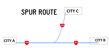
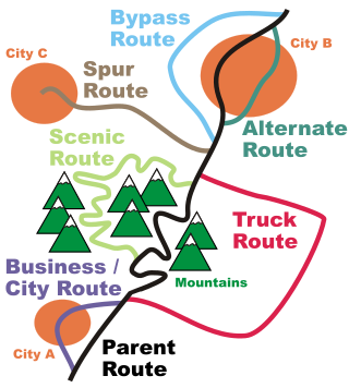
In road transportation in the United States, a special route is a road in a numbered highway system that diverts a specific segment of related traffic away from another road. They are featured in many highway systems; most are found in the Interstate Highway System, U.S. highway system, and several state highway systems. Each type of special route possesses generally defined characteristics and has a defined relationship with its parent route. Typically, special routes share a route number with a dominant route, often referred as the "parent" or "mainline", and are given either a descriptor which may be used either before or after the route name, such as Alternate or Business, or a letter suffix that is attached to the route number. For example, an alternate route of U.S. Route 1 may be called "Alternate U.S. Route 1", "U.S. Route 1 Alternate", or "U.S. Route 1A". Occasionally, a special route will have both a descriptor and a suffix, such as U.S. Route 1A Business.

This article describes the highway systems available in selected countries.

<span class="mw-page-title-main">Roads in Georgia (country)</span> Overview of the international and domestic route network in the country of Georgia

Georgia's road network plays an important role in both domestic and international traffic with the four neighboring countries. This is expressed in the road numbering system. The country has a network of 13 internationally oriented trunk highways that connect the capital Tbilisi, home to about a third of the national population, with its four neighboring countries. This is also the backbone of a network of domestic oriented national roads connecting vital regions with each other.

References

  1. "Japan's Expressway Numbering System Outline" . Retrieved 15 August 2019.