National Register of Historic Places listings in Adams County, Nebraska

Last updated

Location of Adams County in Nebraska Map of Nebraska highlighting Adams County.svg
Location of Adams County in Nebraska

This is a list of the National Register of Historic Places listings in Adams County, Nebraska.

Contents

This is intended to be a complete list of the properties and districts on the National Register of Historic Places in Adams County, Nebraska, United States. The locations of National Register properties and districts for which the latitude and longitude coordinates are included below may be seen on a map. [1]

There are 21 properties and districts listed on the National Register in the county. There are also two former listings.


    This National Park Service list is complete through NPS recent listings posted May 19, 2023. [2]

Map all coordinates using: OpenStreetMap  
Download coordinates as: KML

Current listings

[3] Name on the Register [4] ImageDate listed [5] Location City or townDescription
1 William Brach House
William Brach House Brach House (Hastings, Nebraska) from NE.JPG
William Brach House
February 1, 1979
(#79001429)
823 N. Lincoln Ave.
40°35′33″N98°23′27″W / 40.5925°N 98.390833°W / 40.5925; -98.390833 (William Brach House)
Hastings
2 Burlington Station
Burlington Station Hastings Amtrak station.jpg
Burlington Station
March 29, 1978
(#78001693)
1st St. and St. Joseph Ave.
40°35′02″N98°23′13″W / 40.583889°N 98.386944°W / 40.583889; -98.386944 (Burlington Station)
Hastings
3 Central Hastings Historic District
Central Hastings Historic District Hastings, Nebraska 800-odd N Lincoln Ave.JPG
Central Hastings Historic District
August 21, 2003
(#03000795)
Roughly 7th to 12th; Colorado Ave. to Bellevue Ave.
40°35′35″N98°23′23″W / 40.593056°N 98.389722°W / 40.593056; -98.389722 (Central Hastings Historic District)
Hastings
4 Chautauqua Pavilion
Chautauqua Pavilion Chautauqua Pavilion (Hastings, Nebraska) from N.JPG
Chautauqua Pavilion
October 19, 1978
(#78001692)
Chautauqua Park
40°35′14″N98°24′44″W / 40.587222°N 98.412222°W / 40.587222; -98.412222 (Chautauqua Pavilion)
Hastings
5 Clarke Hotel
Clarke Hotel Clarke Hotel (Hastings, Nebraska) from SE 2.JPG
Clarke Hotel
December 7, 1987
(#87002094)
233 N. Hastings Ave.
40°35′09″N98°23′24″W / 40.585833°N 98.39°W / 40.585833; -98.39 (Clarke Hotel)
Hastings
6 Farrell Block
Farrell Block Farrell Block from NW 2.JPG
Farrell Block
May 1, 1979
(#79001430)
533-537 2nd St., and 112 Denver Ave.
40°35′06″N98°23′17″W / 40.585°N 98.388056°W / 40.585; -98.388056 (Farrell Block)
Hastings
7 Foote Clinic
Foote Clinic Foote Clinic (Hastings NE) from NW 1.JPG
Foote Clinic
March 22, 2016
(#16000104)
422 N. Hastings Ave.
40°35′16″N98°23′23″W / 40.587691°N 98.389642°W / 40.587691; -98.389642 (Foote Clinic)
Hastings
8 Hastings Brewery Building and Bottling Works
Hastings Brewery Building and Bottling Works Hastings Brewery (Hastings, Nebraska) from NE 2.JPG
Hastings Brewery Building and Bottling Works
June 30, 2015
(#15000391)
219 W. 2nd St.
40°35′06″N98°23′02″W / 40.584874°N 98.383838°W / 40.584874; -98.383838 (Hastings Brewery Building and Bottling Works)
Hastings
9 Hastings College
Hastings College Weyer Hall from SW 1.jpg
Hastings College
July 31, 2017
(#100001393)
710 N. Turner Ave.
40°35′26″N98°22′29″W / 40.590606°N 98.374639°W / 40.590606; -98.374639 (Hastings College)
Hastings
10 Hastings Downtown Historic District December 18, 2018
(#100003090)
Roughly bounded by W 3rd St., Burlington Northern RR, N Colorado & N Burlington Aves.
40°35′07″N98°23′19″W / 40.5852°N 98.3887°W / 40.5852; -98.3887 (Hastings Downtown Historic District)
Hastings
11 Hastings Municipal Airport Hangar-Building No. 1
Hastings Municipal Airport Hangar-Building No. 1 Hangar 1 (Hastings, Nebraska) from SE 2.JPG
Hastings Municipal Airport Hangar-Building No. 1
July 22, 2005
(#05000722)
3100 E. 12th St.
40°35′51″N98°25′33″W / 40.5975°N 98.425833°W / 40.5975; -98.425833 (Hastings Municipal Airport Hangar-Building No. 1)
Hastings
12 Heartwell Park Historic District
Heartwell Park Historic District Hastings, Nebraska Heartwell Park from W 1.JPG
Heartwell Park Historic District
March 9, 2000
(#00000168)
105-106 Lakeside Dr., 110-602 Forest Boulevard, and 923 and 1109 N. Elm St.
40°35′43″N98°22′40″W / 40.595278°N 98.377778°W / 40.595278; -98.377778 (Heartwell Park Historic District)
Hastings
13 Jackson-Einspahr Sod House
Jackson-Einspahr Sod House Jackson-Einspahr house from NE 1.JPG
Jackson-Einspahr Sod House
November 8, 2006
(#06000994)
Address Restricted
Holstein
14 McCormick Hall
McCormick Hall McCormick Hall (Hastings, Nebraska) from NW 2.JPG
McCormick Hall
May 12, 1975
(#75001086)
Hastings College campus
40°35′32″N98°22′25″W / 40.592222°N 98.373611°W / 40.592222; -98.373611 (McCormick Hall)
Hastings
15 McCue-Trausch Farmstead
McCue-Trausch Farmstead McCue-Trausch house 1.jpg
McCue-Trausch Farmstead
March 9, 2000
(#00000165)
Northeastern quarter of Section 12, Township 6 North, Range 11 West [6]
40°30′32″N98°29′49″W / 40.50878°N 98.49705°W / 40.50878; -98.49705 (McCue-Trausch Farmstead)
Hastings
16 Nebraska Loan and Trust Company Building
Nebraska Loan and Trust Company Building Nebraska Loan and Trust (Hastings) from SE 1.JPG
Nebraska Loan and Trust Company Building
May 1, 1979
(#79001431)
2nd St. and Lincoln Ave.
40°35′08″N98°23′28″W / 40.585556°N 98.391111°W / 40.585556; -98.391111 (Nebraska Loan and Trust Company Building)
Hastings
17 Nowlan-Dietrich House
Nowlan-Dietrich House Nowlan-Dietrich House from E 1.JPG
Nowlan-Dietrich House
April 17, 1979
(#79001432)
1105 N. Kansas Ave.
40°35′45″N98°23′09″W / 40.595833°N 98.385833°W / 40.595833; -98.385833 (Nowlan-Dietrich House)
Hastings
18 St. Mark's Episcopal Pro-Cathedral
St. Mark's Episcopal Pro-Cathedral St. Mark's (Hastings, Nebraska) from NW.JPG
St. Mark's Episcopal Pro-Cathedral
November 30, 1987
(#87002086)
Junction of 4th and Burlington
40°35′16″N98°23′29″W / 40.587778°N 98.391389°W / 40.587778; -98.391389 (St. Mark's Episcopal Pro-Cathedral)
Hastings
19 Stein Brothers Building
Stein Brothers Building Stein Bros Building from SE.JPG
Stein Brothers Building
May 1, 1979
(#79001433)
630 W. 2nd St.
40°35′07″N98°23′20″W / 40.585278°N 98.388889°W / 40.585278; -98.388889 (Stein Brothers Building)
Hastings
20 Thirty-Two Mile Station Site
Thirty-Two Mile Station Site 32-Mile Creek station ACHS marker 1.JPG
Thirty-Two Mile Station Site
February 20, 1975
(#75001088)
Osage Ave between Assumption and Oak Ridge Rds [7]
40°31′20″N98°28′49″W / 40.52215°N 98.48037°W / 40.52215; -98.48037 (Thirty-Two Mile Station Site)
Hastings Site of stage and Pony Express station, burned by Indians in 1864
21 Victory Building
Victory Building Victory Building from NW 1.JPG
Victory Building
March 31, 1987
(#86003379)
2nd at Saint Joseph Ave.
40°35′06″N98°23′13″W / 40.585°N 98.386944°W / 40.585; -98.386944 (Victory Building)
Hastings

Former listings

[3] Name on the RegisterImageDate listedDate removedLocationCity or townDescription
1 Antioch School
Antioch School Antioch School (Pauline, Nebraska) from NW 2.JPG
Antioch School
September 28, 1988
(#88000914)
March 22, 2016Near Crooked Creek
40°22′43″N98°17′48″W / 40.378710°N 98.296740°W / 40.378710; -98.296740 (Antioch School)
Pauline
2 Ringland Hall May 12, 1975
(#75001087)
July 7, 2004 Hastings College campus
Hastings Demolished in 1987.

See also

Related Research Articles

<span class="mw-page-title-main">National Register of Historic Places listings in Highland County, Ohio</span>

This is a list of the National Register of Historic Places listings in Highland County, Ohio.

<span class="mw-page-title-main">National Register of Historic Places listings in Botetourt County, Virginia</span>

This is a list of the National Register of Historic Places listings in Botetourt County, Virginia.

<span class="mw-page-title-main">National Register of Historic Places listings in Richardson County, Nebraska</span>

This is a list of the National Register of Historic Places listings in Richardson County, Nebraska.

<span class="mw-page-title-main">National Register of Historic Places listings in Cass County, Nebraska</span>

This is a list of the National Register of Historic Places listings in Cass County, Nebraska.

<span class="mw-page-title-main">National Register of Historic Places listings in Cedar County, Nebraska</span>

This is a list of the National Register of Historic Places listings in Cedar County, Nebraska.

<span class="mw-page-title-main">National Register of Historic Places listings in Cheyenne County, Nebraska</span>

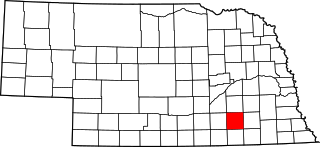
This is a list of the National Register of Historic Places listings in Cheyenne County, Nebraska. It is intended to be a complete list of the properties and districts on the National Register of Historic Places in Cheyenne County, Nebraska, United States. The locations of National Register properties and districts for which the latitude and longitude coordinates are included below, may be seen in a map.

<span class="mw-page-title-main">National Register of Historic Places listings in Butler County, Nebraska</span>

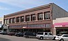
This is a list of the National Register of Historic Places listings in Butler County, Nebraska. It is intended to be a complete list of the properties and districts on the National Register of Historic Places in Butler County, Nebraska, United States. The locations of National Register properties and districts for which the latitude and longitude coordinates are included below, may be seen in a map.

<span class="mw-page-title-main">National Register of Historic Places listings in Gage County, Nebraska</span>

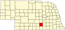
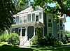
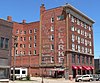
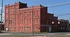
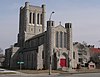
This is a list of the National Register of Historic Places listings in Gage County, Nebraska.

<span class="mw-page-title-main">National Register of Historic Places listings in Fillmore County, Nebraska</span>

This is a list of the National Register of Historic Places listings in Fillmore County, Nebraska.

<span class="mw-page-title-main">National Register of Historic Places listings in Colfax County, Nebraska</span>

This is a list of the National Register of Historic Places listings in Colfax County, Nebraska.

<span class="mw-page-title-main">National Register of Historic Places listings in Adams County, Indiana</span>

This is a list of the National Register of Historic Places listings in Adams County, Indiana.

<span class="mw-page-title-main">National Register of Historic Places listings in Burt County, Nebraska</span>

This is a list of the National Register of Historic Places listings in Burt County, Nebraska.

<span class="mw-page-title-main">National Register of Historic Places listings in Pike County, Ohio</span>

This is a list of the National Register of Historic Places listings in Pike County, Ohio.

<span class="mw-page-title-main">National Register of Historic Places listings in Antelope County, Nebraska</span>

This is a list of the National Register of Historic Places listings in Antelope County, Nebraska.

<span class="mw-page-title-main">National Register of Historic Places listings in Seward County, Nebraska</span>

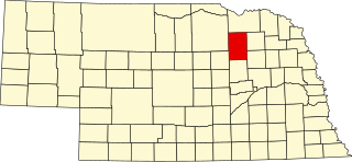
This is a list of the National Register of Historic Places listings in Seward County, Nebraska. It is intended to be a complete list of the properties and districts on the National Register of Historic Places in Seward County, Nebraska, United States. The locations of National Register properties and districts for which the latitude and longitude coordinates are included below, may be seen in a map.

<span class="mw-page-title-main">National Register of Historic Places listings in Lincoln County, Nebraska</span>

This is a list of the National Register of Historic Places listings in Lincoln County, Nebraska. It is intended to be a complete list of the properties and districts on the National Register of Historic Places in Lincoln County, Nebraska, United States. The locations of National Register properties and districts for which the latitude and longitude coordinates are included below, may be seen in a map.

<span class="mw-page-title-main">National Register of Historic Places listings in Red Willow County, Nebraska</span>

This is a list of the National Register of Historic Places listings in Red Willow County, Nebraska.

<span class="mw-page-title-main">National Register of Historic Places listings in Sheridan County, Nebraska</span>

This is a list of the National Register of Historic Places listings in Sheridan County, Nebraska.

<span class="mw-page-title-main">National Register of Historic Places listings in Jefferson County, Missouri</span>

This is a list of the National Register of Historic Places listings in Jefferson County, Missouri.

<span class="mw-page-title-main">National Register of Historic Places listings in Morrill County, Nebraska</span>

This is a list of the National Register of Historic Places listings in Morrill County, Nebraska.

References

  1. The latitude and longitude information provided in this table was derived originally from the National Register Information System, which has been found to be fairly accurate for about 99% of listings. Some locations in this table may have been corrected to current GPS standards.
  2. National Park Service, United States Department of the Interior, "National Register of Historic Places: Weekly List Actions", retrieved May 19, 2023.
  3. 1 2 Numbers represent an alphabetical ordering by significant words. Various colorings, defined here, differentiate National Historic Landmarks and historic districts from other NRHP buildings, structures, sites or objects.
  4. "National Register Information System". National Register of Historic Places . National Park Service. April 24, 2008.
  5. The eight-digit number below each date is the number assigned to each location in the National Register Information System database, which can be viewed by clicking the number.
  6. Renschler, Catherine Traush. "McCue-Trausch Farmhouse". Adams County Historical Society, 2013. Accessed 2013-04-18.
  7. Renschler, Catherine. "Thirty-Two Mile Station". Adams County Historical Society. Archived 2013-08-08 at the Wayback Machine Retrieved 2013-04-07.