National Register of Historic Places listings in Concordia Parish, Louisiana

Last updated

Location of Concordia Parish in Louisiana Map of Louisiana highlighting Concordia Parish.svg
Location of Concordia Parish in Louisiana

This is a list of the National Register of Historic Places listings in Concordia Parish, Louisiana.

Contents

This is intended to be a complete list of the properties on the National Register of Historic Places in Concordia Parish, Louisiana, United States. The locations of National Register properties for which the latitude and longitude coordinates are included below, may be seen in a map. [1]

There are 13 properties listed on the National Register in the parish. One property was once listed, but has since been removed.


    This National Park Service list is complete through NPS recent listings posted February 2, 2024. [2]

Map all coordinates using: OpenStreetMap

Current listings

[3] Name on the RegisterImageDate listed [4] Location City or townDescription
1 Canebrake August 29, 1982
(#82002767)
Along Maxwell Road, about 2.9 miles (4.7 km) east of Spokane, Louisiana and about 9.7 miles (15.6 km) northeast of Ferriday
31°41′56″N91°24′41″W / 31.69881°N 91.4113°W / 31.69881; -91.4113 (Canebrake)
Ferriday vicinity
2 Concordia Parish Courthouse
Concordia Parish Courthouse Concordia Courthouse.jpg
Concordia Parish Courthouse
February 26, 2004
(#04000081)
405 Carter Street
31°34′04″N91°25′43″W / 31.56782°N 91.42866°W / 31.56782; -91.42866 (Concordia Parish Courthouse)
Vidalia
3 DePrato Mounds
DePrato Mounds DePrato Mounds.jpg
DePrato Mounds
October 22, 1998
(#98001258)
Address restricted [5]
Ferriday vicinity
4 Ferriday Commercial Historic District
Ferriday Commercial Historic District Downtown Ferriday, LA IMG 1186.JPG
Ferriday Commercial Historic District
January 27, 1995
(#94001584)
Roughly bounded by South 1st Street, Louisiana Avenue, South 3rd Street and Mickey Gilley Avenue
31°37′46″N91°33′10″W / 31.62933°N 91.55269°W / 31.62933; -91.55269 (Ferriday Commercial Historic District)
Ferriday
5 Frogmore (16CO9)
Frogmore (16CO9) Frogmore Mound Site HRoe 2011 01.jpg
Frogmore (16CO9)
July 28, 2004
(#04000740)
Address restricted [5]
Ferriday vicinity
6 Gillespie
Gillespie Frogmore Plantation Hse 9-12-23.jpg
Gillespie
May 31, 1980
(#80001712)
Frogmore Plantation, 11656 US 84, about 7 miles (11 km) west of Ferriday
31°36′24″N91°40′07″W / 31.60669°N 91.66848°W / 31.60669; -91.66848 (Gillespie)
Ferriday vicinityFrogmore Plantation House
7 Killarney February 18, 1999
(#99000235)
Along LA 569, about 8 miles (13 km) northeast of Ferriday
31°42′32″N91°27′01″W / 31.70886°N 91.45038°W / 31.70886; -91.45038 (Killarney)
Ferriday vicinity
8 Lisburn Plantation House
Lisburn Plantation House Localimagereader.ashx copy.jpg
Lisburn Plantation House
July 26, 1979
(#79001057)
Along Vidal Island Plantation Road, about 4.4 miles (7.1 km) northeast of Ferriday
31°40′16″N91°29′50″W / 31.67117°N 91.49722°W / 31.67117; -91.49722 (Lisburn Plantation House)
Ferriday vicinity
9 MAMIE S. BARRETT (towboat)
MAMIE S. BARRETT (towboat) Barrett bow (1).jpg
MAMIE S. BARRETT (towboat)
April 28, 1983
(#83002811)
On land at Deer Park [6]
31°24′48″N91°34′40″W / 31.41336°N 91.57786°W / 31.41336; -91.57786 (MAMIE S. BARRETT (towboat))
Vidalia vicinityBeached since the Great Flood of 1993 [6]
10 Piazza Cotton Gin
Piazza Cotton Gin Piazza Gin3.jpg
Piazza Cotton Gin
January 27, 1999
(#99000049)
Frogmore Plantation, 11656 US 84, about 7 miles (11 km) west of Ferriday
31°36′21″N91°40′10″W / 31.60584°N 91.66947°W / 31.60584; -91.66947 (Piazza Cotton Gin)
Ferriday vicinity
11 Roseland October 10, 1985
(#85003002)
916 Huntington Stadium Fisherman South Drive
31°37′12″N91°32′20″W / 31.6201°N 91.53889°W / 31.6201; -91.53889 (Roseland)
Ferriday vicinity
12 Tacony Plantation House April 19, 1979
(#79001059)
Along Taconey Plantation Road, about 450 yards (410 m) north of US 84
31°34′50″N91°28′26″W / 31.58055°N 91.47395°W / 31.58055; -91.47395 (Tacony Plantation House)
Vidalia vicinity
13 Zappe Boarding House
Zappe Boarding House Zappe House.jpg
Zappe Boarding House
February 18, 1999
(#99000232)
107 Virginia Avenue
31°37′59″N91°33′07″W / 31.63318°N 91.55204°W / 31.63318; -91.55204 (Zappe Boarding House)
Ferriday

Former listings

[3] Name on the RegisterImageDate listedDate removedLocationCity or townDescription
1 Sheriff Eugene P. Campbell House April 13, 1979
(#79001058)
November 29, 20162 Concordia Avenue
31°33′52″N91°25′28″W / 31.56448°N 91.42435°W / 31.56448; -91.42435 (Sheriff Eugene P. Campbell House)
Vidalia Destroyed by fire on January 20, 1991. [7]

See also

Related Research Articles

<span class="mw-page-title-main">National Register of Historic Places listings in Aleutians East Borough, Alaska</span>

This is a list of the National Register of Historic Places listings in Aleutians East Borough, Alaska.

<span class="mw-page-title-main">National Register of Historic Places listings in Northwest Arctic Borough, Alaska</span>

This is a list of the National Register of Historic Places listings in Northwest Arctic Borough, Alaska.

<span class="mw-page-title-main">National Register of Historic Places listings in North Slope Borough, Alaska</span>

This is a list of the National Register of Historic Places listings in North Slope Borough, Alaska.

<span class="mw-page-title-main">National Register of Historic Places listings in East Baton Rouge Parish, Louisiana</span>

This is a list of the National Register of Historic Places listings in East Baton Rouge Parish, Louisiana.

<span class="mw-page-title-main">National Register of Historic Places listings in Iberia Parish, Louisiana</span>

This is a list of the National Register of Historic Places listings in Iberia Parish, Louisiana.

<span class="mw-page-title-main">National Register of Historic Places listings in Lafourche Parish, Louisiana</span>

This is a list of the National Register of Historic Places listings in Lafourche Parish, Louisiana.

<span class="mw-page-title-main">National Register of Historic Places listings in Lincoln Parish, Louisiana</span>

This is a list of the National Register of Historic Places listings in Lincoln Parish, Louisiana.

<span class="mw-page-title-main">National Register of Historic Places listings in Ascension Parish, Louisiana</span>

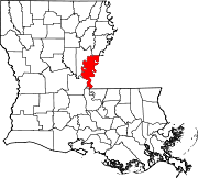
This is a list of the National Register of Historic Places listings in Ascension Parish, Louisiana.

<span class="mw-page-title-main">National Register of Historic Places listings in Edgecombe County, North Carolina</span>

This list includes properties and districts listed on the National Register of Historic Places in Edgecombe County, North Carolina, United States. Click the "Map of all coordinates" link to the right to view a Google map of all properties and districts with latitude and longitude coordinates in the table below.

<span class="mw-page-title-main">National Register of Historic Places listings in Pitt County, North Carolina</span>

This list includes properties and districts listed on the National Register of Historic Places in Pitt County, North Carolina. Click the "Map of all coordinates" link to the right to view an online map of all properties and districts with latitude and longitude coordinates in the table below.

<span class="mw-page-title-main">National Register of Historic Places listings in Dare County, North Carolina</span>

This list includes properties and districts listed on the National Register of Historic Places in Dare County, North Carolina. Click the "Map of all coordinates" link to the right to view a Google map of all properties and districts with latitude and longitude coordinates in the table below.

<span class="mw-page-title-main">National Register of Historic Places listings in Hand County, South Dakota</span>

This is a list of the National Register of Historic Places listings in Hand County, South Dakota.

<span class="mw-page-title-main">National Register of Historic Places listings in Hanson County, South Dakota</span>

This is a list of the National Register of Historic Places listings in Hanson County, South Dakota.

<span class="mw-page-title-main">National Register of Historic Places listings in Madison Parish, Louisiana</span>

This is a list of the National Register of Historic Places listings in Madison Parish, Louisiana.

<span class="mw-page-title-main">National Register of Historic Places listings in Bienville Parish, Louisiana</span>

This is a list of the National Register of Historic Places listings in Bienville Parish, Louisiana.

<span class="mw-page-title-main">National Register of Historic Places listings in Catahoula Parish, Louisiana</span>

This is a list of the National Register of Historic Places listings in Catahoula Parish, Louisiana.

<span class="mw-page-title-main">National Register of Historic Places listings in Caldwell Parish, Louisiana</span>

This is a list of the National Register of Historic Places listings in Caldwell Parish, Louisiana.

<span class="mw-page-title-main">National Register of Historic Places listings in Grant Parish, Louisiana</span>

This is a list of the National Register of Historic Places listings in Grant Parish, Louisiana.

<span class="mw-page-title-main">National Register of Historic Places listings in Armstrong County, Texas</span>

This is a list of the National Register of Historic Places listings in Armstrong County, Texas.

<span class="mw-page-title-main">National Register of Historic Places listings in Copper River Census Area, Alaska</span>

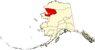
This is a list of the National Register of Historic Places listings in Copper River Census Area, Alaska.

References

  1. The latitude and longitude information provided in this table was derived originally from the National Register Information System, which has been found to be fairly accurate for about 99% of listings. Some locations in this table may have been corrected to current GPS standards.
  2. National Park Service, United States Department of the Interior, "National Register of Historic Places: Weekly List Actions", retrieved February 2, 2024.
  3. 1 2 Numbers represent an alphabetical ordering by significant words. Various colorings, defined here, differentiate National Historic Landmarks and historic districts from other NRHP buildings, structures, sites or objects.
  4. The eight-digit number below each date is the number assigned to each location in the National Register Information System database, which can be viewed by clicking the number.
  5. 1 2 Federal and state laws and practices restrict general public access to information regarding the specific location of this resource. In some cases, this is to protect archeological sites from vandalism, while in other cases it is restricted at the request of the owner. See: Knoerl, John; Miller, Diane; Shrimpton, Rebecca H. (1990), Guidelines for Restricting Information about Historic and Prehistoric Resources, National Register Bulletin, National Park Service, U.S. Department of the Interior, OCLC   20706997 .
  6. 1 2 Hogan, Vershal. "Deer Park Residents: Area Is Worth High-Water Hassles", Natchez Democrat , 2013-02-02. Accessed 2014-03-20.
  7. "National Register of Historic Places Request for Removal: Campbell, Sheriff Eugene P., House" (PDF). National Park Service . Retrieved May 2, 2018.