National Register of Historic Places listings in Lincoln Parish, Louisiana

Last updated
Location of Lincoln Parish in Louisiana Map of Louisiana highlighting Lincoln Parish.svg
Location of Lincoln Parish in Louisiana

This is a list of the National Register of Historic Places listings in Lincoln Parish, Louisiana.

Contents

This is intended to be a complete list of the properties on the National Register of Historic Places in Lincoln Parish, Louisiana, United States. The locations of National Register properties for which the latitude and longitude coordinates are included below, may be seen in a map. [1]

There are 29 properties listed on the National Register in the parish, and one formerly-listed property.

This National Park Service list is complete through NPS recent listings posted December 4, 2020. [2]
Map all coordinates using: OpenStreetMap  
Download coordinates as: KML  ·  GPX

Current listings

[3] Name on the Register [4] ImageDate listed [5] Location City or townDescription
1 Charles P. Adams House February 23, 1996
(#96000145)
549 Main Street
32°31′06″N92°42′48″W / 32.51841°N 92.71325°W / 32.51841; -92.71325 (Charles P. Adams House)
Grambling
2 Autrey House
Autrey House Autrey House.jpg
Autrey House
October 20, 1980
(#80001737)
Junction of LA 151 and LA 152, about 1.1 miles (1.8 km) west of Dubach, Louisiana
32°42′03″N92°40′31″W / 32.70092°N 92.67539°W / 32.70092; -92.67539 (Autrey House)
Dubach
3 Bogard Hall-Louisiana Tech University
Bogard Hall-Louisiana Tech University Bogard Hall at Louisiana Tech IMG 3700.JPG
Bogard Hall-Louisiana Tech University
February 20, 1998
(#98000119)
600 Dan Reneau Drive
32°31′35″N92°38′45″W / 32.52637°N 92.64571°W / 32.52637; -92.64571 (Bogard Hall-Louisiana Tech University)
Ruston
4 Calhoun Farmhouse May 3, 1982
(#82002780)
2575 LA 821, about 5.5 miles (8.9 km) west of Ruston, Louisiana
32°34′57″N92°34′11″W / 32.58262°N 92.56966°W / 32.58262; -92.56966 (Calhoun Farmhouse)
Ruston
5 Dixie Theatre
Dixie Theatre Dixie Theater in Ruston, LA IMG 3778.JPG
Dixie Theatre
October 14, 1993
(#93001105)
212 North Vienna Street
32°31′49″N92°38′16″W / 32.53015°N 92.63775°W / 32.53015; -92.63775 (Dixie Theatre)
Ruston
6 Downtown Ruston Historic District
Downtown Ruston Historic District Ruston Louisiana June 2016 Trenton Street.jpg
Downtown Ruston Historic District
January 31, 2017
(#100000598)
Roughly bounded by North Monroe Street, West Alabama Avenue, East Alabama Avenue, North Bonner Street, East Railroad Avenue, South Vienna Street, West Texas Avenue, South Trenton Street and West Louisiana Avenue
32°31′44″N92°38′19″W / 32.52901°N 92.63871°W / 32.52901; -92.63871 (Downtown Ruston Historic District)
Ruston
7 Fred B. Dubach House September 8, 1983
(#83000528)
7793 Annie Lee Street
32°41′45″N92°39′17″W / 32.69596°N 92.65483°W / 32.69596; -92.65483 (Fred B. Dubach House)
Dubach
8 Federal Building
Federal Building Federal Building - Ruston Louisiana.JPG
Federal Building
October 9, 1974
(#74000926)
201 North Vienna Street
32°31′48″N92°38′18″W / 32.52994°N 92.63827°W / 32.52994; -92.63827 (Federal Building)
Ruston
9 First Presbyterian Church
First Presbyterian Church Presbyterian Church of Ruston, LA IMG 3783.JPG
First Presbyterian Church
January 12, 1984
(#84001323)
212 North Bonner Street
32°31′48″N92°38′11″W / 32.53013°N 92.63645°W / 32.53013; -92.63645 (First Presbyterian Church)
Ruston
10 Grambling State University Historic District
Grambling State University Historic District Grambling University 2 - panoramio.jpg
Grambling State University Historic District
December 7, 2010
(#10000983)
Along Founder Avenue, between College Avenue and Central Avenue
32°31′24″N92°42′49″W / 32.5234°N 92.71372°W / 32.5234; -92.71372 (Grambling State University Historic District)
Grambling
11 Hedgepeth Mounds October 3, 2004
(#04001080)
Address restricted [6]
Vienna
12 Howard Auditorium-Louisiana Tech University
Howard Auditorium-Louisiana Tech University Howard Auditorium at LA Tech IMG 3687.JPG
Howard Auditorium-Louisiana Tech University
February 20, 1998
(#98000113)
Corner of Adams Boulevard and Dan Reneau Drive
32°31′36″N92°38′49″W / 32.52662°N 92.64707°W / 32.52662; -92.64707 (Howard Auditorium-Louisiana Tech University)
Ruston
13 T.L. James House October 18, 1984
(#84000142)
504 North Vienna Street
32°31′58″N92°38′15″W / 32.53268°N 92.63737°W / 32.53268; -92.63737 (T.L. James House)
Ruston
14 Keeny Hall-Louisiana Tech University
Keeny Hall-Louisiana Tech University Keeny Hall at LA Tech IMG 3675.JPG
Keeny Hall-Louisiana Tech University
February 20, 1998
(#98000114)
Keeny Circle
32°31′38″N92°38′47″W / 32.52732°N 92.64634°W / 32.52732; -92.64634 (Keeny Hall-Louisiana Tech University)
Ruston
15 Kidd-Davis House March 29, 1984
(#84001330)
609 North Vienna Street
32°32′03″N92°38′17″W / 32.53416°N 92.63803°W / 32.53416; -92.63803 (Kidd-Davis House)
Ruston
16 Lewis House October 20, 1988
(#88002035)
210 East Alabama Avenue
32°31′48″N92°38′08″W / 32.53003°N 92.63549°W / 32.53003; -92.63549 (Lewis House)
Ruston
17 Meadows House October 8, 1992
(#92001338)
508 North Bonner Street
32°31′59″N92°38′10″W / 32.53302°N 92.63617°W / 32.53302; -92.63617 (Meadows House)
Ruston
18 Prescott Memorial Library-Louisiana Tech University
Prescott Memorial Library-Louisiana Tech University University Hall - Louisiana Tech University.JPG
Prescott Memorial Library-Louisiana Tech University
February 20, 1998
(#98000116)
Keeny Circle
32°31′41″N92°38′46″W / 32.52806°N 92.64623°W / 32.52806; -92.64623 (Prescott Memorial Library-Louisiana Tech University)
Ruston
19 Reese Agriculture Building-Louisiana Tech University February 20, 1998
(#98000118)
Reese Drive
32°31′04″N92°39′20″W / 32.51771°N 92.65546°W / 32.51771; -92.65546 (Reese Agriculture Building-Louisiana Tech University)
Ruston
20 Robinson Hall-Louisiana Tech University
Robinson Hall-Louisiana Tech University Robinson Hall at LA Tech IMG 3763.JPG
Robinson Hall-Louisiana Tech University
February 20, 1998
(#98000117)
Madison Avenue
32°31′40″N92°39′00″W / 32.5278°N 92.65006°W / 32.5278; -92.65006 (Robinson Hall-Louisiana Tech University)
Ruston
21 Ruston Central Fire Station
Ruston Central Fire Station Historic fire station, Ruston, LA IMG 3790.JPG
Ruston Central Fire Station
October 8, 1992
(#92001340)
200 East Mississippi Avenue
32°31′45″N92°38′11″W / 32.52924°N 92.63651°W / 32.52924; -92.63651 (Ruston Central Fire Station)
Ruston
22 Ruston High School
Ruston High School Front view of Ruston, LA, High School IMG 3837.JPG
Ruston High School
October 8, 1992
(#92001335)
900 Bearcat Drive
32°32′05″N92°39′01″W / 32.5348°N 92.65022°W / 32.5348; -92.65022 (Ruston High School)
Ruston
23 Ruston Power and Light Plant July 8, 2019
(#100004151)
300 E. Mississippi Ave.
32°31′46″N92°38′06″W / 32.5294°N 92.6350°W / 32.5294; -92.6350 (Ruston Power and Light Plant)
Ruston
24 Ruston P.O.W. Camp Buildings December 13, 1991
(#91001825)
In Grambling State University West Campus, 2776 LA 150
32°32′05″N92°44′27″W / 32.5346°N 92.74083°W / 32.5346; -92.74083 (Ruston P.O.W. Camp Buildings)
Ruston
25 Ruston State Bank
Ruston State Bank Ruston State Bank.JPG
Ruston State Bank
November 2, 1990
(#90001730)
107 North Trenton Street
32°31′45″N92°38′22″W / 32.52914°N 92.63958°W / 32.52914; -92.63958 (Ruston State Bank)
Ruston
26 Ruston USO February 11, 2011
(#11000009)
212 North Trenton Street, Suite #1
32°31′49″N92°38′20″W / 32.53026°N 92.63898°W / 32.53026; -92.63898 (Ruston USO)
Ruston
27 Toliver Dining Hall-Louisiana Tech University
Toliver Dining Hall-Louisiana Tech University Tolliver Hall.JPG
Toliver Dining Hall-Louisiana Tech University
February 20, 1998
(#98000115)
Wisteria Street
32°31′35″N92°38′57″W / 32.52638°N 92.64904°W / 32.52638; -92.64904 (Toliver Dining Hall-Louisiana Tech University)
Ruston
28 Townsend House June 25, 1982
(#82002779)
410 North Bonner Street
32°31′56″N92°38′11″W / 32.53217°N 92.63648°W / 32.53217; -92.63648 (Townsend House)
Ruston
29 Walnut Creek Baptist Church October 4, 1984
(#84000014)
End of Walnut Creek Church Road, about 1.64 miles (2.64 km) northwest of Simsboro
32°33′10″N92°48′25″W / 32.55287°N 92.80689°W / 32.55287; -92.80689 (Walnut Creek Baptist Church)
Simsboro

Former listings

[3] Name on the RegisterImageDate listedDate removedLocationCity or townSummary
1 Vicksburg, Shreveport and Pacific Depot
Vicksburg, Shreveport and Pacific Depot Railroad depot in Ruston, LA IMG 3826.JPG
Vicksburg, Shreveport and Pacific Depot
October 8, 1992
(#92001337)
November 29, 2016101 East Railroad Avenue
32°31′42″N92°38′16″W / 32.52838°N 92.63788°W / 32.52838; -92.63788 (Vicksburg, Shreveport and Pacific Depot)
Ruston Buildings delisted after being demolished at uncertain date. [7]

See also

Related Research Articles

National Register of Historic Places listings in Orleans Parish, Louisiana

The following properties are listed on the National Register of Historic Places in Orleans Parish, Louisiana.

National Register of Historic Places listings in East Baton Rouge Parish, Louisiana

This is a list of the National Register of Historic Places listings in East Baton Rouge Parish, Louisiana.

National Register of Historic Places listings in East Feliciana Parish, Louisiana

This is a list of the National Register of Historic Places listings in East Feliciana Parish, Louisiana.

National Register of Historic Places listings in West Feliciana Parish, Louisiana

This is a list of the National Register of Historic Places listings in West Feliciana Parish, Louisiana.

National Register of Historic Places listings in Iberia Parish, Louisiana

This is a list of the National Register of Historic Places listings in Iberia Parish, Louisiana.

National Register of Historic Places listings in Lafourche Parish, Louisiana

This is a list of the National Register of Historic Places listings in Lafourche Parish, Louisiana.

National Register of Historic Places listings in Ascension Parish, Louisiana

This is a list of the National Register of Historic Places listings in Ascension Parish, Louisiana.

National Register of Historic Places listings in Ouachita Parish, Louisiana

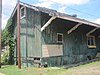
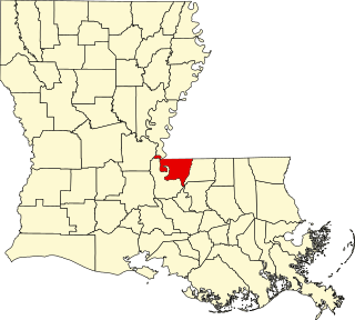
This is a list of the National Register of Historic Places listings in Ouachita Parish, Louisiana.

National Register of Historic Places listings in St. Martin Parish, Louisiana

This is a list of the National Register of Historic Places listings in St. Martin Parish, Louisiana.

National Register of Historic Places listings in Madison Parish, Louisiana

This is a list of the National Register of Historic Places listings in Madison Parish, Louisiana.

National Register of Historic Places listings in Webster Parish, Louisiana

This is a list of the National Register of Historic Places listings in Webster Parish, Louisiana.

National Register of Historic Places listings in Vermilion Parish, Louisiana

This is a list of the National Register of Historic Places listings in Vermilion Parish, Louisiana.

National Register of Historic Places listings in Washington Parish, Louisiana

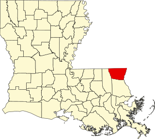
This is a list of the National Register of Historic Places listings in Washington Parish, Louisiana.

National Register of Historic Places listings in Tensas Parish, Louisiana

This is a list of the National Register of Historic Places listings in Tensas Parish, Louisiana.

National Register of Historic Places listings in Bienville Parish, Louisiana

This is a list of the National Register of Historic Places listings in Bienville Parish, Louisiana.

National Register of Historic Places listings in Catahoula Parish, Louisiana

This is a list of the National Register of Historic Places listings in Catahoula Parish, Louisiana.

National Register of Historic Places listings in Concordia Parish, Louisiana

This is a list of the National Register of Historic Places listings in Concordia Parish, Louisiana.

National Register of Historic Places listings in Beauregard Parish, Louisiana

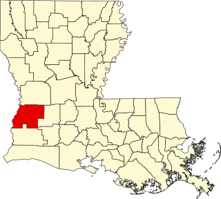
This is a list of the National Register of Historic Places listings in Beauregard Parish, Louisiana.

National Register of Historic Places listings in Caldwell Parish, Louisiana

This is a list of the National Register of Historic Places listings in Caldwell Parish, Louisiana.

National Register of Historic Places listings in Grant Parish, Louisiana

This is a list of the National Register of Historic Places listings in Grant Parish, Louisiana.

References

  1. The latitude and longitude information provided in this table was derived originally from the National Register Information System, which has been found to be fairly accurate for about 99% of listings. Some locations in this table may have been corrected to current GPS standards.
  2. "National Register of Historic Places: Weekly List Actions". National Park Service, United States Department of the Interior. Retrieved on December 4, 2020.
  3. 1 2 Numbers represent an alphabetical ordering by significant words. Various colorings, defined here, differentiate National Historic Landmarks and historic districts from other NRHP buildings, structures, sites or objects.
  4. "National Register Information System". National Register of Historic Places . National Park Service. March 13, 2009.
  5. The eight-digit number below each date is the number assigned to each location in the National Register Information System database, which can be viewed by clicking the number.
  6. Federal and state laws and practices restrict general public access to information regarding the specific location of this resource. In some cases, this is to protect archeological sites from vandalism, while in other cases it is restricted at the request of the owner. See: Knoerl, John; Miller, Diane; Shrimpton, Rebecca H. (1990), Guidelines for Restricting Information about Historic and Prehistoric Resources, National Register Bulletin, National Park Service, U.S. Department of the Interior, OCLC   20706997 .
  7. National Register staff. "National Register of Historic Places Removal: Vicksburg, Shreveport and Pacific Depot" (PDF). National Park Service . Retrieved August 10, 2018.