This is a list of Registered Historic Places in Lincoln, Rhode Island .
Bristol | Kent | Newport | Providence | Washington |
This National Park Service list is complete through NPS recent listings posted February 9, 2024. [1]
| [2] | Name on the Register [3] | Image | Date listed [4] | Location | City or town | Description |
|---|---|---|---|---|---|---|
| 1 | Albion Historic District |  | July 19, 1984 (#84001899) | Roughly bounded by Berkshire Dr., Willow Lane, Ledge Way, Kennedy Boulevard, and School and Main Sts. 41°57′06″N71°27′26″W / 41.951667°N 71.457222°W | Lincoln | |
| 2 | Eleazer Arnold House |  | November 24, 1968 (#68000006) | Great Rd. (RI 123) near its junction with RI 126 41°54′10″N71°25′14″W / 41.902778°N 71.420556°W | Lincoln | |
| 3 | Israel Arnold House |  | December 18, 1970 (#70000017) | Great Rd. 41°54′17″N71°25′35″W / 41.904722°N 71.426389°W | Lincoln | |
| 4 | Ballou House | 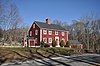 | August 30, 1984 (#84001908) | Albion Rd. 41°56′48″N71°28′21″W / 41.946667°N 71.4725°W | Lincoln | |
| 5 | Blackstone Canal |  | May 6, 1971 (#71000030) | From Steeple and Promenade Sts. in Providence to the Massachusetts border in North Smithfield 41°55′16″N71°25′21″W / 41.921111°N 71.4225°W | Lincoln, Cumberland, Woonsocket, and North Smithfield | Initial listing extended from Providence, through Pawtucket, and as far north as Lincoln; a 1991 expansion (#91001536) extended it to the state line; the canal itself extended into Worcester County, Massachusetts, where it is the subject of separate listings. |
| 6 | Elliot-Harris-Miner House |  | August 30, 1984 (#84001984) | 1406 Old Louisquisset Pike 41°52′43″N71°26′11″W / 41.878611°N 71.436389°W | Lincoln | |
| 7 | Great Road Historic District | 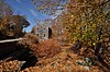 | July 22, 1974 (#74000051) | Great Rd. 41°54′21″N71°25′41″W / 41.905833°N 71.428056°W | Lincoln | |
| 8 | Hearthside |  | April 24, 1973 (#73000069) | Great Rd. 41°54′23″N71°25′50″W / 41.906389°N 71.430556°W | Lincoln | |
| 9 | Jenckes House | 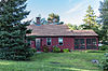 | August 30, 1984 (#84002019) | 81 Jenckes Hill Rd. 41°54′16″N71°27′32″W / 41.904444°N 71.458889°W | Lincoln | |
| 10 | Jenckes House |  | October 10, 1984 (#84000088) | 1730 Old Louisquisset Pike 41°53′44″N71°26′55″W / 41.895556°N 71.448611°W | Lincoln | |
| 11 | Lime Kilns |  | August 30, 1984 (#84002015) | Off Louisquisset Pike, Sherman and Dexter Rock Rds. | Lincoln | Ruined remnants of three colonia-era lime kilns at different locations. |
| 12 | Limerock Village Historic District | 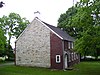 | May 23, 1974 (#74000052) | In an irregular pattern along Smith, Wilbur, and Great Rds., and Old Louisquisset Pike 41°55′40″N71°27′22″W / 41.927778°N 71.456111°W | Lincoln | |
| 13 | Lonsdale Historic District |  | May 25, 1984 (#84002022) | Lonsdale Ave., Blackstone Ct., and Front, Main, Cook, Broad, Mill, Cross and Blackstone Sts. 41°54′34″N71°24′11″W / 41.909444°N 71.403056°W | Cumberland and Lincoln | |
| 14 | Manville Company Worker Housing Historic District | 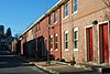 | April 2, 2009 (#08001183) | Bounded by Chestnut St., Angle St., Railroad St., Winter St., Fall St., Spring St., Park Way, Almeida Dr., and Main St. 41°58′13″N71°28′18″W / 41.970278°N 71.471667°W | Lincoln | |
| 15 | Old Ashton Historic District | 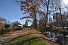 | August 30, 1984 (#84002037) | Lower River Rd. and Blackstone Canal Towpath 41°56′11″N71°26′04″W / 41.936389°N 71.434444°W | Lincoln | Now a site on the Blackstone River Bikeway State Park |
| 16 | Pullen Corner School | 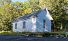 | August 30, 1984 (#84002039) | Angell and Whipple 41°53′44″N71°28′06″W / 41.895556°N 71.468333°W | Lincoln | |
| 17 | Sassafras Site, RI-55 | 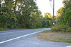 | November 1, 1984 (#84000360) | Between Albion Rd. and the Blackstone River [5] 41°57′08″N71°27′03″W / 41.952222°N 71.450833°W | Lincoln | |
| 18 | Saylesville Historic District | 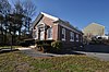 | August 30, 1984 (#84002049) | Roughly bounded by Memorial Ave., Scotts Road, Industrial Circle, Smithfield Ave., and Woodland Court 41°53′33″N71°24′37″W / 41.8925°N 71.410278°W | Lincoln | |
| 19 | Saylesville Meetinghouse |  | November 28, 1978 (#78000008) | Smithfield Ave. 41°54′02″N71°25′06″W / 41.900556°N 71.418333°W | Lincoln | |
| 20 | Whipple-Cullen House and Barn |  | November 14, 1991 (#91001647) | Old River Rd. south of its junction with George Washington Highway 41°55′49″N71°26′31″W / 41.930278°N 71.441944°W | Lincoln |


