National Register of Historic Places listings in New Madrid County, Missouri

Last updated
Location of New Madrid County in Missouri Map of Missouri highlighting New Madrid County.svg
Location of New Madrid County in Missouri

This is a list of the National Register of Historic Places listings in New Madrid County, Missouri.

Contents

This is intended to be a complete list of the properties and districts on the National Register of Historic Places in New Madrid County, Missouri, United States. Latitude and longitude coordinates are provided for many National Register properties and districts; these locations may be seen together in a map. [1]

National Register of Historic Places federal list of historic sites in the United States

The National Register of Historic Places (NRHP) is the United States federal government's official list of districts, sites, buildings, structures, and objects deemed worthy of preservation for their historical significance. A property listed in the National Register, or located within a National Register Historic District, may qualify for tax incentives derived from the total value of expenses incurred preserving the property.

New Madrid County, Missouri County in the United States

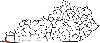
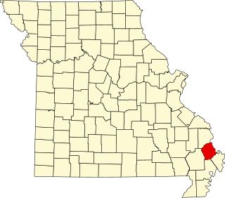
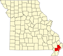
New Madrid County is a county located in the Bootheel of the U.S. state of Missouri. As of the 2010 census, the population was 18,956. The largest city and county seat is New Madrid, located on the northern side of the Kentucky Bend in the Mississippi River, where it has formed an oxbow around an exclave of Fulton County, Kentucky. This feature has also been known as New Madrid Bend or Madrid Bend, for the city.

Missouri State of the United States of America

Missouri is a state in the Midwestern United States. With over six million residents, it is the 18th-most populous state of the Union. The largest urban areas are St. Louis, Kansas City, Springfield, and Columbia; the capital is Jefferson City. The state is the 21st-most extensive in area. In the South are the Ozarks, a forested highland, providing timber, minerals, and recreation. The Missouri River, after which the state is named, flows through the center of the state into the Mississippi River, which makes up Missouri's eastern border.

There are 10 properties and districts listed on the National Register in the county.

This National Park Service list is complete through NPS recent listings posted May 18, 2018. [2]
Map all coordinates using: OpenStreetMap  ·  Google Maps
Download coordinates as: KML  ·  GPX

Current listings

[3] Name on the Register Image Date listed [4] Location City or town Description
1 Double Bridges Archeological Site Upload image July 25, 1974
(#74001085)
2.5 miles (4.0 km) north of Stewart, along Open Bayou [5]
36°24′38″N89°37′00″W / 36.410556°N 89.616667°W / 36.410556; -89.616667 (Double Bridges Archeological Site)
Portageville
2 Howardville School
Howardville School Howardville-School-mo.jpg
Howardville School
November 22, 2017
(#100001847)
6916 U.S. Route 61
36°34′04″N89°36′10″W / 36.567778°N 89.602778°W / 36.567778; -89.602778 (Howardville School)
Howardville
3 Hunter-Dawson House
Hunter-Dawson House HunterDawson.jpg
Hunter-Dawson House
August 28, 2012
(#12000563)
312 Dawson Rd.
36°35′48″N89°31′31″W / 36.596667°N 89.525278°W / 36.596667; -89.525278 (Hunter-Dawson House)
New Madrid
4 Hurricane Ridge Site Upload image November 9, 1972
(#72000725)
Address Restricted
Catron
5 King II Archeological Site Upload image June 26, 1975
(#75001070)
Address Restricted
Howardville
6 La Plant Archeological Site Upload image July 25, 1974
(#74001084)
Northwest of Bayouville at the center of the northeastern quarter of Section 1, Township 23 North, Range 15 East [6] :140
36°40′07″N89°22′42″W / 36.668611°N 89.378333°W / 36.668611; -89.378333 (La Plant Archeological Site)
La Forge
7 Lilbourn Fortified Village Archeological Site
Lilbourn Fortified Village Archeological Site Lilbourn Fortified Village primary mound.jpg
Lilbourn Fortified Village Archeological Site
July 29, 1969
(#69000118)
U.S. Routes 61/62, in and east of Mound Cemetery [7] :72
36°34′17″N89°35′15″W / 36.571389°N 89.587500°W / 36.571389; -89.587500 (Lilbourn Fortified Village Archeological Site)
Lilbourn
8 Portwood Village and Mound Upload image November 25, 1977
(#77000812)
Address Restricted
Portageville
9 Sikeston Fortified Village Archeological Site Upload image February 12, 1971
(#71000471)
South of Sikeston near the confluence of the North Cut and St. John's Ditches [8]
36°48′55″N89°33′35″W / 36.815278°N 89.559722°W / 36.815278; -89.559722 (Sikeston Fortified Village Archeological Site)
Sikeston
10 St. Johns-Laplant IV Archeological District Upload image August 28, 1975
(#75001069)
Southeastern quarter of the southwestern quarter of Section 11, Township 23 North, Range 15 East [6] :140
36°38′47″N89°24′21″W / 36.646389°N 89.405833°W / 36.646389; -89.405833 (St. Johns-Laplant IV Archeological District)
Bayouville

See also

National Register of Historic Places listings in Missouri Wikimedia list article

This is a list of properties and historic districts in Missouri on the National Register of Historic Places. There are NRHP listings in all of Missouri's 114 counties and the one independent city of St. Louis.

Related Research Articles

This is a list of properties and districts in Mississippi that are listed on the National Register of Historic Places. There are 1,407 sites distributed among all of Mississippi's 82 counties.

National Register of Historic Places listings in Baldwin County, Alabama Wikimedia list article

This is a list of the National Register of Historic Places listings in Baldwin County, Alabama.

National Register of Historic Places listings in Tuscaloosa County, Alabama Wikimedia list article

This is a list of the National Register of Historic Places listings in Tuscaloosa County, Alabama.

National Register of Historic Places listings in Fulton County, Kentucky Wikimedia list article

This is a list of the National Register of Historic Places listings in Fulton County, Kentucky.

National Register of Historic Places listings in Leflore County, Mississippi Wikimedia list article

This is a list of the National Register of Historic Places listings in Leflore County, Mississippi.

National Register of Historic Places listings in Coahoma County, Mississippi Wikimedia list article

This is a list of the National Register of Historic Places listings in Coahoma County, Mississippi.

National Register of Historic Places listings in Washington County, Mississippi Wikimedia list article

This is a list of the National Register of Historic Places listings in Washington County, Mississippi.

National Register of Historic Places listings in Bolivar County, Mississippi Wikimedia list article

This is a list of the National Register of Historic Places listings in Bolivar County, Mississippi.

National Register of Historic Places listings in Arkansas County, Arkansas Wikimedia list article

This is a list of the National Register of Historic Places listings in Arkansas County, Arkansas.

National Register of Historic Places listings in Monroe County, Arkansas Wikimedia list article

This is a list of the National Register of Historic Places listings in Monroe County, Arkansas.

National Register of Historic Places listings in Monroe County, Missouri Wikimedia list article

This is a list of the National Register of Historic Places listings in Monroe County, Missouri.

National Register of Historic Places listings in Carter County, Missouri Wikimedia list article

This is a list of the National Register of Historic Places listings in Carter County, Missouri.

National Register of Historic Places listings in Clark County, Missouri Wikimedia list article

This is a list of the National Register of Historic Places listings in Clark County, Missouri.

National Register of Historic Places listings in Callaway County, Missouri Wikimedia list article

This is a list of the National Register of Historic Places listings in Callaway County, Missouri.

National Register of Historic Places listings in Washington County, Missouri Wikimedia list article

This is a list of the National Register of Historic Places listings in Washington County, Missouri.

National Register of Historic Places listings in Mississippi County, Missouri Wikimedia list article

This is a list of the National Register of Historic Places listings in Mississippi County, Missouri.

National Register of Historic Places listings in Pemiscot County, Missouri Wikimedia list article

This is a list of the National Register of Historic Places listings in Pemiscot County, Missouri.

National Register of Historic Places listings in Vernon County, Missouri Wikimedia list article

This is a list of the National Register of Historic Places listings in Vernon County, Missouri.

National Register of Historic Places listings in Scott County, Missouri Wikimedia list article

This is a list of the National Register of Historic Places listings in Scott County, Missouri.

National Register of Historic Places listings in Ste. Genevieve County, Missouri Wikimedia list article

This is a list of the National Register of Historic Places listings in Ste. Genevieve County, Missouri.

References

  1. The latitude and longitude information provided in this table was derived originally from the National Register Information System, which has been found to be fairly accurate for about 99% of listings. For about 1% of NRIS original coordinates, experience has shown that one or both coordinates are typos or otherwise extremely far off; some corrections may have been made. A more subtle problem causes many locations to be off by up to 150 yards, depending on location in the country: most NRIS coordinates were derived from tracing out latitude and longitudes off of USGS topographical quadrant maps created under the North American Datum of 1927 , which differs from the current, highly accurate WGS84 GPS system used by most on-line maps. Chicago is about right, but NRIS longitudes in Washington are higher by about 4.5 seconds, and are lower by about 2.0 seconds in Maine. Latitudes differ by about 1.0 second in Florida. Some locations in this table may have been corrected to current GPS standards.
  2. "National Register of Historic Places: Weekly List Actions". National Park Service, United States Department of the Interior. Retrieved on May 18, 2018.
  3. Numbers represent an ordering by significant words. Various colorings, defined here, differentiate National Historic Landmarks and historic districts from other NRHP buildings, structures, sites or objects.
  4. The eight-digit number below each date is the number assigned to each location in the National Register Information System database, which can be viewed by clicking the number.
  5. Morse, Dan F., and Phyllis A. Morse, eds. The Lower Mississippi Valley Expeditions of Clarence Bloomfield Moore . Tuscaloosa: U of Alabama P, 1998, 156.
  6. 1 2 O'Brien, Michael J., and Robert C. Dunnell, eds. Changing Perspectives on the Archaeology of the Central Mississippi Valley. Tuscaloosa and London: U of Alabama P, 1998.
  7. Chapman, Carl, et al. "Investigation and Comparison of Two Fortified Mississippian Traditional Archaeological Sites in Southeastern Missouri: A Preliminary Compilation". Missouri Archaeologist 38 Whole Volume (1977).
  8. Sussenbach, Tom, and R. Barry Lewis. Archaeological Investigations in Carlisle, Hickman, and Fulton Counties, Kentucky: Site Survey and Excavations. Western Kentucky Project Report #4. Champaign: U of Illinois Department of Anthropology, 1987, 2.