National Register of Historic Places listings in Saline County, Missouri

Last updated

Location of Saline County in Missouri Map of Missouri highlighting Saline County.svg
Location of Saline County in Missouri

This is a list of the National Register of Historic Places listings in Saline County, Missouri.

Contents

This is intended to be a complete list of the properties and districts on the National Register of Historic Places in Saline County, Missouri, United States. Latitude and longitude coordinates are provided for many National Register properties and districts; these locations may be seen together in a map. [1]

There are 32 properties and districts listed on the National Register in the county, including 3 National Historic Landmarks.


    This National Park Service list is complete through NPS recent listings posted September 15, 2023. [2]

Map all coordinates using: OpenStreetMap

Current listings

[3] Name on the RegisterImageDate listed [4] Location City or townDescription
1 Arrow Rock Ferry Landing May 1, 2013
(#08000664)
Northern extension of 2nd St. [5]
39°04′27″N92°56′37″W / 39.074167°N 92.943611°W / 39.074167; -92.943611 (Arrow Rock Ferry Landing)
Arrow Rock
2 Arrow Rock
Arrow Rock Houston Tavern, Arrow Rock State Park, Arrow Rock (Saline County, Missouri).jpg
Arrow Rock
October 15, 1966
(#66000422)
Arrow Rock State Park
39°04′00″N92°56′41″W / 39.066667°N 92.944722°W / 39.066667; -92.944722 (Arrow Rock)
Arrow Rock
3 Arrow Rock State Historic Site Bridge March 4, 1985
(#85000516)
Southeast of Arrow Rock
39°04′06″N92°56′39″W / 39.068333°N 92.944167°W / 39.068333; -92.944167 (Arrow Rock State Historic Site Bridge)
Arrow Rock
4 Arrow Rock State Historic Site Grave Shelter February 27, 1985
(#85000534)
Southeast of Arrow Rock
39°04′06″N92°56′39″W / 39.068333°N 92.944167°W / 39.068333; -92.944167 (Arrow Rock State Historic Site Grave Shelter)
Arrow Rock
5 Arrow Rock State Historic Site Lookout Shelter February 27, 1985
(#85000535)
East of Arrow Rock
39°04′16″N92°56′33″W / 39.071111°N 92.9425°W / 39.071111; -92.9425 (Arrow Rock State Historic Site Lookout Shelter)
Arrow Rock
6 Arrow Rock State Historic Site Open Shelter February 28, 1985
(#85000536)
Southeast of Arrow Rock
39°04′04″N92°56′31″W / 39.067778°N 92.941944°W / 39.067778; -92.941944 (Arrow Rock State Historic Site Open Shelter)
Arrow Rock
7 Arrow Rock Tavern
Arrow Rock Tavern ARROW ROCK TAVERN.jpg
Arrow Rock Tavern
February 23, 1972
(#72000729)
Main St.
39°04′03″N92°56′42″W / 39.0675°N 92.945°W / 39.0675; -92.945 (Arrow Rock Tavern)
Arrow Rock
8 Baity Hall
Baity Hall Baity Hall.jpg
Baity Hall
June 25, 1986
(#86001396)
Missouri Valley College, 500 E. College
39°06′28″N93°11′23″W / 39.107778°N 93.189722°W / 39.107778; -93.189722 (Baity Hall)
Marshall
9 George Caleb Bingham House
George Caleb Bingham House George Caleb Bingham House, Arrow Rock State Park, Arrow Rock (Saline County, Missouri).jpg
George Caleb Bingham House
October 15, 1966
(#66000423)
1st and High Sts. in Arrow Rock State Park
39°04′15″N92°56′35″W / 39.070833°N 92.943056°W / 39.070833; -92.943056 (George Caleb Bingham House)
Arrow Rock
10 Henry Blosser House December 29, 1978
(#78001675)
East of Malta Bend off U.S. 65
39°11′24″N93°17′28″W / 39.19°N 93.291111°W / 39.19; -93.291111 (Henry Blosser House)
Malta Bend
11 Buckner House
Buckner House Buckner House (Marshall, Missouri).jpg
Buckner House
April 19, 1984
(#84002581)
125 N. Brunswick Ave.
39°07′22″N93°11′25″W / 39.122778°N 93.190278°W / 39.122778; -93.190278 (Buckner House)
Marshall
12 Chicago and Alton Depot
Chicago and Alton Depot Chicago and Alton Depot (Marshall, Missouri).jpg
Chicago and Alton Depot
June 27, 1979
(#79001395)
Sebree St.
39°07′31″N93°11′54″W / 39.125278°N 93.198333°W / 39.125278; -93.198333 (Chicago and Alton Depot)
Marshall
13 First Christian Church
First Christian Church FIRST CHRISTIAN CHURCH, SWEET SPRINGS, SALINE COUNTY, MO.jpg
First Christian Church
September 12, 1980
(#80002394)
400 Bridge St.
38°57′46″N93°25′09″W / 38.962778°N 93.419167°W / 38.962778; -93.419167 (First Christian Church)
Sweet Springs
14 First Presbyterian Church
First Presbyterian Church First Presbyterian Church (Marshall, Missouri).jpg
First Presbyterian Church
September 20, 1977
(#77000814)
212 E. North St.
39°07′15″N93°11′39″W / 39.120833°N 93.194167°W / 39.120833; -93.194167 (First Presbyterian Church)
Marshall
15 Fisher-Gabbert Archeological Site March 16, 1972
(#72000730)
1 mile (1.6 km) northeast of central Miami [6]
39°19′51″N93°12′48″W / 39.330833°N 93.213333°W / 39.330833; -93.213333 (Fisher-Gabbert Archeological Site)
Miami
16 Fitzgibbon Hospital
Fitzgibbon Hospital Fitzgibbon Hospital (Marshall, Missouri).jpg
Fitzgibbon Hospital
October 17, 2012
(#12000874)
868 S. Brunswick Ave.
39°06′44″N93°11′25″W / 39.112348°N 93.190284°W / 39.112348; -93.190284 (Fitzgibbon Hospital)
Marshall
17 Free Will Baptist Church of Pennytown April 19, 1988
(#88000388)
Off MO UU 8 miles (13 km) southeast of Marshall
39°00′59″N93°10′47″W / 39.016389°N 93.179722°W / 39.016389; -93.179722 (Free Will Baptist Church of Pennytown)
Marshall
18 Gumbo Point Archeological Site August 25, 1969
(#69000125)
Southern side of the Missouri River, 2 miles (3.2 km) north of the junction of U.S. Route 65 and Route 127 [7]
39°13′33″N93°23′18″W / 39.225833°N 93.388333°W / 39.225833; -93.388333 (Gumbo Point Archeological Site)
Grand Pass
19 Guthrey Archeological Site December 2, 1970
(#70000349)
2 miles (3.2 km) east of Miami [8]
39°20′04″N93°11′34″W / 39.334444°N 93.192778°W / 39.334444; -93.192778 (Guthrey Archeological Site)
Miami
20 Mt. Carmel Historic District November 10, 2009
(#09000900)
290th Rd. and Missouri Highway 41 North
39°12′39″N93°13′09″W / 39.210726°N 93.219190°W / 39.210726; -93.219190 (Mt. Carmel Historic District)
Marshall
21 George A. Murrell House November 14, 1997
(#97001435)
0.75 miles (1.21 km) east and 0.5 miles (0.80 km) north of MO E and H
39°02′17″N93°04′25″W / 39.038056°N 93.073611°W / 39.038056; -93.073611 (George A. Murrell House)
Napton
22 Neff Tavern Smokehouse
Neff Tavern Smokehouse Neff Tavern (closeup) - Santa Fe Trail Historic Site near Arrow Rock, Missouri.png
Neff Tavern Smokehouse
November 30, 1978
(#78001676)
Northeast of Napton off MO 41
39°05′48″N93°02′39″W / 39.096667°N 93.044167°W / 39.096667; -93.044167 (Neff Tavern Smokehouse)
Napton
23 Old Fort
Old Fort Van-meter-fort.jpg
Old Fort
January 13, 1972
(#72000731)
Van Meter State Park [9]
39°16′22″N93°15′49″W / 39.272778°N 93.263611°W / 39.272778; -93.263611 (Old Fort)
Miami
24 Plattner Archeological Site March 4, 1971
(#71000474)
1 mile (1.6 km) north of Malta Bend [8]
39°12′38″N93°21′24″W / 39.210556°N 93.356667°W / 39.210556; -93.356667 (Plattner Archeological Site)
Malta Bend
25 Saline County Courthouse
Saline County Courthouse Marshall-mo-ch.jpg
Saline County Courthouse
August 24, 1977
(#77000815)
Courthouse Sq.
39°07′15″N93°11′47″W / 39.120833°N 93.196389°W / 39.120833; -93.196389 (Saline County Courthouse)
Marshall
26 Santa Fe Trail-Grand Pass Trail Segments April 21, 1994
(#94000324)
Junction of US 65 and County Road T
39°11′43″N93°26′29″W / 39.195278°N 93.441389°W / 39.195278; -93.441389 (Santa Fe Trail-Grand Pass Trail Segments)
Grand Pass
27 Santa Fe Trail-Saline County Trail Segments June 30, 1994
(#94000615)
Co. Rd. 416 (Rural Rt. 3) west of junction with MO 41
39°11′17″N93°14′21″W / 39.188056°N 93.239167°W / 39.188056; -93.239167 (Santa Fe Trail-Saline County Trail Segments)
Stanhope
28 William B. Sappington House
William B. Sappington House WILLIAM B. SAPPINGTON HOUSE.jpg
William B. Sappington House
January 21, 1970
(#70000348)
3 miles (4.8 km) southwest of Arrow Rock on CR TT
39°02′24″N92°59′09″W / 39.04°N 92.985833°W / 39.04; -92.985833 (William B. Sappington House)
Arrow Rock
29 Sweet Springs Historic District
Sweet Springs Historic District SWEET SPRINGS HISTORIC DISTRICT, SALINE COUNTY, MO.jpg
Sweet Springs Historic District
December 10, 1997
(#97001485)
200-217 W. Lexington Ave and 211 Marshall St.
38°57′54″N93°25′04″W / 38.965°N 93.417778°W / 38.965; -93.417778 (Sweet Springs Historic District)
Sweet Springs Originally roughly along Lexington, Marshall, Miller, and Spring Sts., until a boundary decrease of April 26, 2010
30 Utz Site October 15, 1966
(#66000424)
Southern half of Section 19, Township 52 North, Range 21 West [8]
39°16′23″N93°15′12″W / 39.273167°N 93.253333°W / 39.273167; -93.253333 (Utz Site)
Marshall Site is a full mile long from southwest to northeast [8]
31 Van Meter State Park Combination Building February 27, 1985
(#85000537)
Van Meter State Park
39°15′53″N93°16′05″W / 39.264722°N 93.268056°W / 39.264722; -93.268056 (Van Meter State Park Combination Building)
Marshall
32 Van Meter State Park Shelter Building February 28, 1985
(#85000538)
Van Meter State Park
39°15′57″N93°16′09″W / 39.265833°N 93.269167°W / 39.265833; -93.269167 (Van Meter State Park Shelter Building)
Marshall

See also

Related Research Articles

<span class="mw-page-title-main">National Register of Historic Places listings in St. Louis County, Missouri</span>

This is a list of the National Register of Historic Places listings in St. Louis County, Missouri.

<span class="mw-page-title-main">National Register of Historic Places listings in Leavenworth County, Kansas</span>

This is a list of the National Register of Historic Places listings in Leavenworth County, Kansas.

<span class="mw-page-title-main">National Register of Historic Places listings in Dewey County, South Dakota</span>

This is a list of the National Register of Historic Places listings in Dewey County, South Dakota.

<span class="mw-page-title-main">National Register of Historic Places listings in Saline County, Arkansas</span>

This is a list of the National Register of Historic Places listings in Saline County, Arkansas.

<span class="mw-page-title-main">National Register of Historic Places listings in Monroe County, Missouri</span>

This is a list of the National Register of Historic Places listings in Monroe County, Missouri.

<span class="mw-page-title-main">National Register of Historic Places listings in Pike County, Missouri</span>

This is a list of the National Register of Historic Places listings in Pike County, Missouri.

<span class="mw-page-title-main">National Register of Historic Places listings in Buchanan County, Missouri</span>

This is a list of the National Register of Historic Places listings in Buchanan County, Missouri.

<span class="mw-page-title-main">National Register of Historic Places listings in Marion County, Missouri</span>

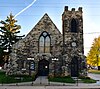
The following properties are listed on the National Register of Historic Places in Marion County, Missouri.

<span class="mw-page-title-main">National Register of Historic Places listings in Clay County, Missouri</span>

This is a list of the National Register of Historic Places listings in Clay County, Missouri.

<span class="mw-page-title-main">National Register of Historic Places listings in Jefferson County, Missouri</span>

This is a list of the National Register of Historic Places listings in Jefferson County, Missouri.

<span class="mw-page-title-main">National Register of Historic Places listings in Wright County, Missouri</span>

This is a list of the National Register of Historic Places listings in Wright County, Missouri.

<span class="mw-page-title-main">National Register of Historic Places listings in Phelps County, Missouri</span>

This is a list of the National Register of Historic Places listings in Phelps County, Missouri.

<span class="mw-page-title-main">National Register of Historic Places listings in Barry County, Missouri</span>

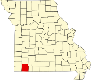
This is a list of the National Register of Historic Places listings in Barry County, Missouri.

<span class="mw-page-title-main">National Register of Historic Places listings in Washington County, Missouri</span>

This is a list of the National Register of Historic Places listings in Washington County, Missouri.

<span class="mw-page-title-main">National Register of Historic Places listings in Mississippi County, Missouri</span>

This is a list of the National Register of Historic Places listings in Mississippi County, Missouri.

<span class="mw-page-title-main">National Register of Historic Places listings in New Madrid County, Missouri</span>

This is a list of the National Register of Historic Places listings in New Madrid County, Missouri.

<span class="mw-page-title-main">National Register of Historic Places listings in Pemiscot County, Missouri</span>

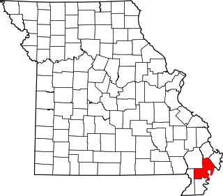
This is a list of the National Register of Historic Places listings in Pemiscot County, Missouri.

<span class="mw-page-title-main">National Register of Historic Places listings in Vernon County, Missouri</span>

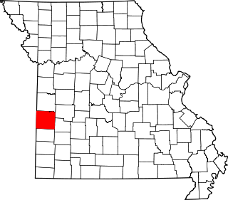
This is a list of the National Register of Historic Places listings in Vernon County, Missouri.

<span class="mw-page-title-main">National Register of Historic Places listings in Ste. Genevieve County, Missouri</span>

This is a list of the National Register of Historic Places listings in Ste. Genevieve County, Missouri.

<span class="mw-page-title-main">National Register of Historic Places listings in Linn County, Missouri</span>

This is a list of the National Register of Historic Places listings in Linn County, Missouri.

References

  1. The latitude and longitude information provided in this table was derived originally from the National Register Information System, which has been found to be fairly accurate for about 99% of listings. Some locations in this table may have been corrected to current GPS standards.
  2. National Park Service, United States Department of the Interior, "National Register of Historic Places: Weekly List Actions", retrieved September 15, 2023.
  3. Numbers represent an alphabetical ordering by significant words. Various colorings, defined here, differentiate National Historic Landmarks and historic districts from other NRHP buildings, structures, sites or objects.
  4. The eight-digit number below each date is the number assigned to each location in the National Register Information System database, which can be viewed by clicking the number.
  5. Places To Go in Missouri, National Park Service, 2010-04-06. Accessed 2013-05-17.
  6. Artz, Joe Alan. "Inferring Season of Occupation from Fish Scales: An Archaeological Approach". Plains Anthropologist 25.87 (1980): 47-61: 52.
  7. O'Brien, Patricia J., and Kevin Hart. "The Utlaut Site (23SA162W): An Oneota-Historic Missouri Burial Site". Missouri Archaeologist 34.1-2 (1972): 48-74: 49.
  8. 1 2 3 4 Bray, Robert T. "European Trade Goods from the Utz Site and the Search for Fort Orleans". Missouri Archaeologist 39 Whole Volume (1978): 24.
  9. Berry, Brewton. "The 'Old Fort' in Saline County". Missouri Archaeologist 5.1 (1939): 3-6: 3.