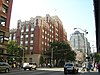
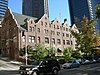
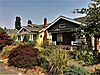
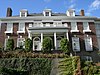
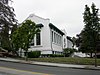
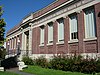
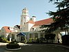
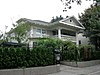
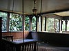
[3] Name on the Register [4] Image Date listed [5] Location Description 1 12th Avenue South Bridge 12th Avenue South Bridge July 16, 1982 (# 82004227 12th Ave., S. over Dearborn St. 47°35′46″N 122°18′58″W / 47.596111°N 122.316111°W / 47.596111; -122.316111 (12th Avenue South Bridge ) Built in 1911, it is the state's oldest surviving steel arch bridge . Renamed the Jose Rizal Bridge in 1974, the bridge spans Dearborn Street, connecting Beacon Hill and the International District . [6] [7] Also part of the Historic Bridges and Tunnels in Washington Thematic Resource listing [8] 2 1411 Fourth Avenue Building 1411 Fourth Avenue Building May 28, 1991 (# 91000633 1411 Fourth Ave. 47°36′34″N 122°20′06″W / 47.609444°N 122.335°W / 47.609444; -122.335 (1411 Fourth Avenue Building ) 3 14th Avenue South Bridge 14th Avenue South Bridge July 16, 1982 (# 82004228 Spanned Duwamish River 47°34′13″N 122°21′02″W / 47.570278°N 122.350556°W / 47.570278; -122.350556 (14th Avenue South Bridge ) Now demolished. Also known as the South Park Bridge , this Scherzer Rolling Lift double-leaf bascule bridge was the only bridge of its type in the state. It opened in 1931 and spanned the Duwamish River , connecting the South Park neighborhood with the rest of Seattle. It was demolished in 2010 due to safety concerns. [9] Also part of the Historic Bridges and Tunnels in Washington Thematic Resource listing [8] 4 1600 East John Street Apartments 1600 East John Street Apartments May 14, 2013 (# 13000278 1600 E. John St. 47°37′12″N 122°18′40″W / 47.619926°N 122.311020°W / 47.619926; -122.311020 (1600 East John Street Apartments ) 5 1926 Model Brick Home 1926 Model Brick Home December 6, 2016 (# 16000829 2600 E. Montlake Pl. 47°38′36″N 122°18′11″W / 47.643280°N 122.302962°W / 47.643280; -122.302962 (1926 Model Brick Home ) 6 Admiral Theater Admiral Theater December 11, 1989 (# 89002098 2343 California Avenue SW 47°34′58″N 122°23′11″W / 47.58276°N 122.38646°W / 47.58276; -122.38646 (Admiral Theater ) 7 Admiral's House, 13th Naval District Admiral's House, 13th Naval District February 13, 2013 (# 13000016 2001 W. Garfield St. 47°37′56″N 122°23′19″W / 47.632111°N 122.388621°W / 47.632111; -122.388621 (Admiral's House, 13th Naval District ) 8 Agen Warehouse Agen Warehouse January 23, 1998 (# 97001673 1201 Western Ave. 47°36′21″N 122°20′15″W / 47.605833°N 122.3375°W / 47.605833; -122.3375 (Agen Warehouse ) 9 Alaska Trade Building Alaska Trade Building May 6, 1971 (# 71000871 1915-1919 1st Ave. 47°36′39″N 122°20′28″W / 47.6108°N 122.3411°W / 47.6108; -122.3411 (Alaska Trade Building ) 10 John B. Allen School John B. Allen School May 11, 2011 (# 11000280 6532 Phinney Ave. N. 47°40′38″N 122°21′14″W / 47.6772°N 122.3539°W / 47.6772; -122.3539 (John B. Allen School ) 11 Arboretum Sewer Trestle Arboretum Sewer Trestle July 16, 1982 (# 82004229 Crosses 26th Ave., E. between Roanoke and E. Miller St. 47°38′33″N 122°17′52″W / 47.6425°N 122.2978°W / 47.6425; -122.2978 (Arboretum Sewer Trestle ) Built in 1910, this sewer viaduct is an early example of a reinforced concrete arch bridge . Ornamental in design, today it serves as a pedestrian bridge over Lake Washington Boulevard in the Washington Park Arboretum . [10] Also part of the Historic Bridges and Tunnels in Washington Thematic Resource listing [8] 12 Arctic Building Arctic Building November 28, 1978 (# 78002749 306 Cherry St. 47°36′14″N 122°19′50″W / 47.6039°N 122.3306°W / 47.6039; -122.3306 (Arctic Building ) 13 Alfredo & Susan Lytle Arreguin House and Studio Alfredo & Susan Lytle Arreguin House and Studio May 9, 2022 (# 100007697 2412 NE 80th St. 47°41′12″N 122°18′05″W / 47.6868°N 122.3013°W / 47.6868; -122.3013 (Alfredo & Susan Lytle Arreguin House and Studio ) 14 Assay Office/German House Assay Office/German House March 16, 1972 (# 72001271 613 9th Ave. 47°36′22″N 122°19′25″W / 47.6061°N 122.3236°W / 47.6061; -122.3236 (Assay Office/German House ) 15 Aurora Avenue Bridge Aurora Avenue Bridge July 16, 1982 (# 82004230 Aurora Ave., N. over Lake Washington Ship Canal 47°39′10″N 122°20′46″W / 47.6528°N 122.3461°W / 47.6528; -122.3461 (Aurora Avenue Bridge ) Built in 1931, this cantilever truss bridge carries traffic on State Route 99 (Aurora Avenue) over the west end of Lake Union , connecting the neighborhoods of Queen Anne and Fremont . [11] Also part of the Historic Bridges and Tunnels in Washington Thematic Resource listing [8] 16 Ballard Avenue Historic District Ballard Avenue Historic District July 1, 1976 (# 76001885 Ballard Ave. from NW Market to NW Dock Sts. 47°39′59″N 122°22′55″W / 47.6664°N 122.3819°W / 47.6664; -122.3819 (Ballard Avenue Historic District ) 17 Ballard Bridge Ballard Bridge July 16, 1982 (# 82004231 Spans Lake Washington Ship Canal 47°39′47″N 122°22′30″W / 47.6631°N 122.375°W / 47.6631; -122.375 (Ballard Bridge ) Built in 1917, the Ballard Bridge is one of the oldest examples in the state of a double-leaf bascule bridge . [8] It spans Salmon Bay in the Lake Washington Ship Canal , connecting the neighborhood of Ballard with Queen Anne and Magnolia . [12] Also part of the Historic Bridges and Tunnels in Washington Thematic Resource listing [8] 18 Ballard Carnegie Library Ballard Carnegie Library June 15, 1979 (# 79002535 2026 N. West Market St. 47°40′08″N 122°22′54″W / 47.6689°N 122.3817°W / 47.6689; -122.3817 (Ballard Carnegie Library ) part of the Carnegie Libraries of Washington TR (AD) 19 Ballard-Howe House Ballard-Howe House March 26, 1979 (# 79002536 22 W. Highland Dr. 47°37′48″N 122°21′23″W / 47.63°N 122.3564°W / 47.63; -122.3564 (Ballard-Howe House ) 20 Ballast Island Ballast Island January 27, 2021 (# 100006067 At the foot of South Washington and South Main Sts., along the waterfront 47°36′02″N 122°20′11″W / 47.6005°N 122.3365°W / 47.6005; -122.3365 (Ballast Island ) 21 Richard A. Ballinger House Richard A. Ballinger House May 28, 1976 (# 76001886 1733 39th Ave. 47°37′04″N 122°16′56″W / 47.6178°N 122.2822°W / 47.6178; -122.2822 (Richard A. Ballinger House ) 22 Julian and Marajane Barksdale House Julian and Marajane Barksdale House December 24, 2013 (# 13000995 13226 42nd Ave. NE 47°43′26″N 122°16′50″W / 47.7238°N 122.2805°W / 47.7238; -122.2805 (Julian and Marajane Barksdale House ) 23 Barnes Building Barnes Building February 24, 1975 (# 75001853 2320-2322 1st Ave. 47°36′49″N 122°20′42″W / 47.613611°N 122.345°W / 47.613611; -122.345 (Barnes Building ) 24 Bay View Brewery Bay View Brewery January 23, 2013 (# 12001221 3100–3222 Airport Way S. 47°34′34″N 122°19′15″W / 47.576193°N 122.320772°W / 47.576193; -122.320772 (Bay View Brewery ) 25 Beacon Hill School Beacon Hill School August 14, 2019 (# 100004297 2524 16th Ave. S 47°34′50″N 122°18′44″W / 47.5805°N 122.3121°W / 47.5805; -122.3121 (Beacon Hill School ) 26 Bell Apartments Bell Apartments July 12, 1974 (# 74001957 2326 1st Ave. 47°36′51″N 122°20′44″W / 47.614167°N 122.345556°W / 47.614167; -122.345556 (Bell Apartments ) 27 Jesse C. Bowles House Jesse C. Bowles House November 6, 1986 (# 86003162 2540 Shoreland Dr. S 47°34′51″N 122°17′02″W / 47.580833°N 122.283889°W / 47.580833; -122.283889 (Jesse C. Bowles House ) 28 Building No. 105, Boeing Airplane Company Building No. 105, Boeing Airplane Company August 26, 1971 (# 71000872 Purcell Ave. 47°31′06″N 122°17′42″W / 47.518333°N 122.295°W / 47.518333; -122.295 (Building No. 105, Boeing Airplane Company ) 29 Bon Marche Department Store Bon Marche Department Store December 6, 2016 (# 16000830 300 Pine St. 47°36′40″N 122°20′18″W / 47.611107°N 122.338433°W / 47.611107; -122.338433 (Bon Marche Department Store ) Now Macy's ; the former flagship store of The Bon Marché . 30 Butterworth Building Butterworth Building May 14, 1971 (# 71000873 1921 1st Ave. 47°36′39″N 122°20′28″W / 47.610833°N 122.341111°W / 47.610833; -122.341111 (Butterworth Building ) 31 Calhoun Hotel Calhoun Hotel April 23, 2013 (# 13000208 2000 2nd Ave. 47°36′43″N 122°20′30″W / 47.612054°N 122.341664°W / 47.612054; -122.341664 (Calhoun Hotel ) 32 Cambridge Apartments Cambridge Apartments April 5, 2016 (# 16000148 903 Union St. 47°36′42″N 122°19′48″W / 47.611561°N 122.329868°W / 47.611561; -122.329868 (Cambridge Apartments ) 33 Camlin Hotel Camlin Hotel March 25, 1999 (# 99000405 1619 Ninth St. 47°36′39″N 122°19′55″W / 47.610833°N 122.331944°W / 47.610833; -122.331944 (Camlin Hotel ) 34 Century 21-Washington State Coliseum Century 21-Washington State Coliseum May 10, 2018 (# 100002406 305 Harrison St. 47°37′20″N 122°21′15″W / 47.6221°N 122.3541°W / 47.6221; -122.3541 (Century 21-Washington State Coliseum ) Now Climate Pledge Arena . 35 Chelsea Family Hotel Chelsea Family Hotel December 14, 1978 (# 78002750 620 W. Olympic Pl. 47°37′41″N 122°21′53″W / 47.628056°N 122.364722°W / 47.628056; -122.364722 (Chelsea Family Hotel ) 36 James and Pat Chiarelli House James and Pat Chiarelli House May 14, 2013 (# 13000279 843 NE 100th St. 47°42′04″N 122°19′07″W / 47.701122°N 122.318635°W / 47.701122; -122.318635 (James and Pat Chiarelli House ) 37 Chief Sealth High School Chief Sealth High School September 14, 2022 (# 100008187 2600 SW Thistle St. 47°31′47″N 122°22′02″W / 47.5296°N 122.36716°W / 47.5296; -122.36716 (Chief Sealth High School ) 38 Chinese Baptist Church Chinese Baptist Church July 31, 1986 (# 86002094 925 S. King St. 47°35′54″N 122°19′07″W / 47.598333°N 122.318611°W / 47.598333; -122.318611 (Chinese Baptist Church ) 39 Chittenden Locks and Lake Washington Ship Canal Chittenden Locks and Lake Washington Ship Canal December 14, 1978 (# 78002751 Salmon Bay 47°39′19″N 122°21′07″W / 47.655278°N 122.351944°W / 47.655278; -122.351944 (Chittenden Locks and Lake Washington Ship Canal ) Chittenden Locks and Lake Washington Ship Canal 40 Church of the Blessed Sacrament, Priory, and School Church of the Blessed Sacrament, Priory, and School January 12, 1984 (# 84003479 5040-5041 9th Ave., NE 47°40′00″N 122°19′03″W / 47.666667°N 122.3175°W / 47.666667; -122.3175 (Church of the Blessed Sacrament, Priory, and School ) 41 Cobb Building Cobb Building August 3, 1984 (# 84003485 1301-1309 4th Ave. 47°37′04″N 122°20′02″W / 47.617778°N 122.333889°W / 47.617778; -122.333889 (Cobb Building ) 42 Coliseum Theater Coliseum Theater July 7, 1975 (# 75001854 5th Ave. and Pike St. 47°36′41″N 122°20′02″W / 47.611389°N 122.333889°W / 47.611389; -122.333889 (Coliseum Theater ) 43 Colman Automotive Building Colman Automotive Building February 13, 2013 (# 13000017 401 E. Pine St. 47°36′54″N 122°19′36″W / 47.615081°N 122.326532°W / 47.615081; -122.326532 (Colman Automotive Building ) 44 Colman Building Colman Building March 16, 1972 (# 72001272 811 1st Ave. 47°36′14″N 122°20′03″W / 47.603889°N 122.334167°W / 47.603889; -122.334167 (Colman Building ) 45 Colman Park & Dose Terrace Stairs Colman Park & Dose Terrace Stairs February 10, 2020 (# 100004959 Roughly bounded by South Massachusetts St., South Dose Terrace, 31st Ave. South, & the Lake Washington shoreline 47°35′01″N 122°17′18″W / 47.5835°N 122.2883°W / 47.5835; -122.2883 (Colman Park & Dose Terrace Stairs ) 46 Colonial Hotel Colonial Hotel April 29, 1982 (# 82004232 1119-1123 1st Ave. 47°36′22″N 122°20′11″W / 47.606111°N 122.336389°W / 47.606111; -122.336389 (Colonial Hotel ) 47 Colonnade Hotel Colonnade Hotel August 7, 2017 (# 100001443 107 Pine St. 47°36′35″N 122°20′26″W / 47.60982°N 122.340469°W / 47.60982; -122.340469 (Colonnade Hotel ) 48 Columbia City Historic District Columbia City Historic District September 8, 1980 (# 80004000 Roughly bounded by S. Hudson and S. Alaska Sts., 35th and Rainier Aves. 47°33′33″N 122°17′08″W / 47.559167°N 122.285556°W / 47.559167; -122.285556 (Columbia City Historic District ) 49 Frank B. Cooper Elementary School Frank B. Cooper Elementary School March 26, 2003 (# 03000161 4408 Delridge Way SW 47°33′49″N 122°21′41″W / 47.563611°N 122.361389°W / 47.563611; -122.361389 (Frank B. Cooper Elementary School ) 50 Cornish School Cornish School August 29, 1977 (# 77001337 710 E. Roy St. 47°37′32″N 122°19′19″W / 47.625556°N 122.321944°W / 47.625556; -122.321944 (Cornish School ) 51 Cowen Park Bridge Cowen Park Bridge July 16, 1982 (# 82004233 15th Ave., N. 47°40′16″N 122°18′45″W / 47.671111°N 122.3125°W / 47.671111; -122.3125 (Cowen Park Bridge ) In 1936, the Works Progress Administration constructed this open-spandrel reinforced concrete arch bridge . The bridge, notable for its Art Deco motifs, is part of 15th Ave NE, spanning the eastern edge of the ravine in Cowen Park . [13] [14] Also part of the Historic Bridges and Tunnels in Washington Thematic Resource listing [8] 52 Daughters of the American Revolution-Rainier Chapter House Daughters of the American Revolution-Rainier Chapter House March 20, 2019 (# 100003525 800 East Roy St. 47°37′30″N 122°19′20″W / 47.6251°N 122.3221°W / 47.6251; -122.3221 (Daughters of the American Revolution-Rainier Chapter House ) 53 De La Mar Apartments De La Mar Apartments August 18, 1980 (# 80004001 115 W. Olympic Pl. 47°37′36″N 122°21′28″W / 47.626667°N 122.357778°W / 47.626667; -122.357778 (De La Mar Apartments ) 54 Henry H. Dearborn House Henry H. Dearborn House January 23, 1998 (# 97001672 1117 Minor Ave. 47°36′40″N 122°19′27″W / 47.611111°N 122.324167°W / 47.611111; -122.324167 (Henry H. Dearborn House ) 55 Charles P. and Ida Dose House Charles P. and Ida Dose House December 24, 2013 (# 13000996 2121 31st Ave., S 47°35′02″N 122°17′36″W / 47.583787°N 122.293394°W / 47.583787; -122.293394 (Charles P. and Ida Dose House ) 56 Dunn Gardens Dunn Gardens December 15, 1994 (# 94001435 13533 Northshire Rd. NW. 47°43′39″N 122°21′50″W / 47.7275°N 122.363889°W / 47.7275; -122.363889 (Dunn Gardens ) 57 Duwamish (fireboat) Duwamish (fireboat) June 30, 1989 (# 89001448 Lake Washington Ship Canal, Chittenden Locks 47°39′57″N 122°23′39″W / 47.665833°N 122.394167°W / 47.665833; -122.394167 (Duwamish (fireboat)) 58 Duwamish Number 1 Site Duwamish Number 1 Site October 18, 1977 (# 77001338 Address Restricted 59 Eagles Auditorium Building Eagles Auditorium Building July 14, 1983 (# 83003338 1416 7th Ave. 47°36′40″N 122°19′51″W / 47.611111°N 122.330833°W / 47.611111; -122.330833 (Eagles Auditorium Building ) 60 El Rio Apartment Hotel El Rio Apartment Hotel November 30, 1999 (# 99001453 1922-1928 9th Ave. 47°36′59″N 122°20′01″W / 47.616389°N 122.333611°W / 47.616389; -122.333611 (El Rio Apartment Hotel ) 61 Ellsworth Storey Cottages Historic District Ellsworth Storey Cottages Historic District July 6, 1976 (# 76001891 1706-1816 S. Lake Washington Blvd. and 1725-1729 S. 36th Ave. 47°35′15″N 122°17′17″W / 47.5875°N 122.288056°W / 47.5875; -122.288056 (Ellsworth Storey Cottages Historic District ) 62 Ellsworth Storey Residences Ellsworth Storey Residences April 14, 1972 (# 72001276 260, 270 E. Dorffel Dr. 47°37′18″N 122°17′07″W / 47.621667°N 122.285278°W / 47.621667; -122.285278 (Ellsworth Storey Residences ) 63 Jim and Betty Eng House Jim and Betty Eng House September 30, 2019 (# 100004460 8310 Beacon Ave. S. 47°31′45″N 122°17′16″W / 47.5293°N 122.2878°W / 47.5293; -122.2878 (Jim and Betty Eng House ) 64 Federal Office Building Federal Office Building April 30, 1979 (# 79003155 909 1st Ave. 47°36′16″N 122°20′06″W / 47.604444°N 122.335°W / 47.604444; -122.335 (Federal Office Building ) 65 Federal Reserve Bank of San Francisco, Seattle Branch Federal Reserve Bank of San Francisco, Seattle Branch February 4, 2013 (# 11000985 1015 2nd Avenue 47°36′19″N 122°20′09″W / 47.605382°N 122.335793°W / 47.605382; -122.335793 (Federal Reserve Bank of San Francisco, Seattle Branch ) 66 Pierre P. Ferry House Pierre P. Ferry House April 18, 1979 (# 79002537 1531 10th Ave., E. 47°38′03″N 122°19′08″W / 47.634167°N 122.318889°W / 47.634167; -122.318889 (Pierre P. Ferry House ) 67 Fir Lodge Fir Lodge January 22, 2021 (# 100006070 2717 61st Ave. SW 47°34′43″N 122°24′41″W / 47.5785°N 122.4113°W / 47.5785; -122.4113 (Fir Lodge ) 68 Fire Station No. 18 Fire Station No. 18 June 19, 1973 (# 73001876 5427 Russell Ave., NW 47°40′07″N 122°22′54″W / 47.668611°N 122.381667°W / 47.668611; -122.381667 (Fire Station No. 18 ) 69 Fire Station No. 23 Fire Station No. 23 September 10, 1971 (# 71000874 18th Ave. and Columbia St. 47°36′32″N 122°18′26″W / 47.608889°N 122.307222°W / 47.608889; -122.307222 (Fire Station No. 23 ) 70 Fire Station No. 25 Fire Station No. 25 April 14, 1972 (# 72001273 1400 Harvard Ave. 47°36′49″N 122°19′15″W / 47.613611°N 122.320833°W / 47.613611; -122.320833 (Fire Station No. 25 ) 71 First Methodist Episcopal Church First Methodist Episcopal Church January 3, 2011 (# 10001105 801 Fifth Ave. 47°36′20″N 122°19′53″W / 47.605556°N 122.331389°W / 47.605556; -122.331389 (First Methodist Episcopal Church ) 72 First Methodist Protestant Church of Seattle First Methodist Protestant Church of Seattle May 14, 1993 (# 93000364 128 16th Ave. E. 47°37′11″N 122°18′37″W / 47.619722°N 122.310278°W / 47.619722; -122.310278 (First Methodist Protestant Church of Seattle ) 73 Ford Motor Company Assembly Plant Ford Motor Company Assembly Plant October 9, 2013 (# 13000823 4735 E. Marginal Way 47°33′29″N 122°20′25″W / 47.558131°N 122.340353°W / 47.558131; -122.340353 (Ford Motor Company Assembly Plant ) 74 Fort Lawton Fort Lawton August 15, 1978 (# 78002752 On Magnolia Bluff 47°39′33″N 122°24′49″W / 47.659167°N 122.413611°W / 47.659167; -122.413611 (Fort Lawton ) 75 Fourth Church of Christ, Scientist Fourth Church of Christ, Scientist January 2, 2013 (# 12001138 1119 8th Ave. 47°36′33″N 122°19′48″W / 47.60907°N 122.32995°W / 47.60907; -122.32995 (Fourth Church of Christ, Scientist ) 76 Freeway Park Freeway Park December 19, 2019 (# 100004789 700 Seneca St. 47°36′35″N 122°19′52″W / 47.6097°N 122.3311°W / 47.6097; -122.3311 (Freeway Park ) 77 Fremont Bridge Fremont Bridge July 16, 1982 (# 82004234 Spans Lake Washington Ship Canal 47°38′52″N 122°20′55″W / 47.647778°N 122.348611°W / 47.647778; -122.348611 (Fremont Bridge ) part of the Historic Bridges and Tunnels in Washington TR 78 Fremont Building Fremont Building November 12, 1992 (# 92001587 3419 Fremont Ave. N. 47°39′01″N 122°20′58″W / 47.650278°N 122.349444°W / 47.650278; -122.349444 (Fremont Building ) 79 Frink Park Frink Park November 20, 2019 (# 100004646 Roughly bounded by 31st Ave. S., Lake Washington Blvd. & 34th Ave., S. King St. & S. Main St. 47°35′57″N 122°17′27″W / 47.5993°N 122.2907°W / 47.5993; -122.2907 (Frink Park ) 80 Caroline Kline Galland House Caroline Kline Galland House February 8, 1980 (# 80004002 1605 17th Ave. 47°36′57″N 122°18′34″W / 47.615833°N 122.309444°W / 47.615833; -122.309444 (Caroline Kline Galland House ) 81 Gas Works Park Gas Works Park January 2, 2013 (# 02000862 2000 N. Northlake Way 47°38′46″N 122°20′06″W / 47.6460°N 122.3350°W / 47.6460; -122.3350 (Gas Works Park ) Added January 2013, more than a decade after it was nominated. [15] 82 Georgetown Steam Plant Georgetown Steam Plant 1978 (# 78002755 Off WA 99 at King County Airport 47°32′35″N 122°18′54″W / 47.543056°N 122.315°W / 47.543056; -122.315 (Georgetown Steam Plant ) 83 Globe Building, Beebe Building and Hotel Cecil Globe Building, Beebe Building and Hotel Cecil April 29, 1982 (# 82004235 1001-1023 1st Ave. 47°36′19″N 122°20′08″W / 47.605278°N 122.335556°W / 47.605278; -122.335556 (Globe Building, Beebe Building and Hotel Cecil ) 84 J. S. Graham Store J. S. Graham Store December 7, 1989 (# 89002094 119 Pine St. 47°36′36″N 122°20′19″W / 47.61°N 122.338611°W / 47.61; -122.338611 (J. S. Graham Store ) 85 Grand Pacific Hotel Grand Pacific Hotel May 13, 1982 (# 82004236 1115-1117 1st Ave. 47°36′21″N 122°20′10″W / 47.605833°N 122.336111°W / 47.605833; -122.336111 (Grand Pacific Hotel ) Originally known as the Starr Block 86 Guiry and Schillestad Building Guiry and Schillestad Building August 28, 1985 (# 85001941 2101-2111 1st Ave. 47°36′44″N 122°20′35″W / 47.612222°N 122.343056°W / 47.612222; -122.343056 (Guiry and Schillestad Building ) 87 Harvard-Belmont District Harvard-Belmont District May 13, 1982 (# 82004237 Bellevue Pl., Broadway, Boylston and Harvard Aves. 47°37′43″N 122°19′19″W / 47.628611°N 122.321944°W / 47.628611; -122.321944 (Harvard-Belmont District ) 88 Hawthorne Square Hawthorne Square August 14, 2012 (# 08001301 4800 Fremont Ave. N. 47°39′50″N 122°20′57″W / 47.663971°N 122.349268°W / 47.663971; -122.349268 (Hawthorne Square ) Seattle Apartment Buildings, 1900-1957 Multiple Property Submission (MPS) 89 Highland Apartments Highland Apartments December 7, 2018 (# 100003254 931 11th Ave. E 47°37′40″N 122°19′05″W / 47.6277°N 122.3181°W / 47.6277; -122.3181 (Highland Apartments ) 90 Samuel Hill House Samuel Hill House May 3, 1976 (# 76001887 814 E. Highland Dr. 47°37′51″N 122°19′14″W / 47.630833°N 122.320556°W / 47.630833; -122.320556 (Samuel Hill House ) 91 Hoge Building Hoge Building April 14, 1983 (# 83003339 705 2nd Ave. 47°36′12″N 122°19′56″W / 47.603333°N 122.332222°W / 47.603333; -122.332222 (Hoge Building ) 92 Holyoke Building Holyoke Building June 3, 1976 (# 76001888 1018-1022 1st Ave. 47°36′20″N 122°20′05″W / 47.605556°N 122.334722°W / 47.605556; -122.334722 (Holyoke Building ) 93 Home of the Good Shepherd Home of the Good Shepherd May 23, 1978 (# 78002753 Sunnyside, N. and 50th St. 47°39′51″N 122°19′51″W / 47.664167°N 122.330833°W / 47.664167; -122.330833 (Home of the Good Shepherd ) 94 Hotel Sorrento Hotel Sorrento September 20, 2021 (# 100006936 900 Madison St. 47°36′31″N 122°19′36″W / 47.6087°N 122.3267°W / 47.6087; -122.3267 (Hotel Sorrento ) 95 Hull Building Hull Building January 27, 1983 (# 83003340 2401-2405 1st Ave. 47°36′51″N 122°20′49″W / 47.614167°N 122.346944°W / 47.614167; -122.346944 (Hull Building ) 96 Samuel Hyde House Samuel Hyde House April 12, 1982 (# 82004238 3726 E. Madison St. 47°37′55″N 122°17′01″W / 47.631944°N 122.283611°W / 47.631944; -122.283611 (Samuel Hyde House ) 97 Immanuel Lutheran Church Immanuel Lutheran Church February 25, 1982 (# 82004239 1215 Thomas St. 47°37′15″N 122°19′51″W / 47.620833°N 122.330833°W / 47.620833; -122.330833 (Immanuel Lutheran Church ) 98 Interlake Public School Interlake Public School July 14, 1983 (# 83003341 4416 Wallingford Ave., N. 47°39′40″N 122°20′05″W / 47.661111°N 122.334722°W / 47.661111; -122.334722 (Interlake Public School ) 99 Iron Pergola Iron Pergola August 26, 1971 (# 71000875 1st Ave. and Yesler Way 47°36′07″N 122°19′58″W / 47.601944°N 122.332778°W / 47.601944; -122.332778 (Iron Pergola ) 100 John N. Cobb (fisheries research vessel) John N. Cobb (fisheries research vessel) February 11, 2009 (# 09000047 7600 Sand Point Way NE. 47°41′16″N 122°15′34″W / 47.687837°N 122.259381°W / 47.687837; -122.259381 (John N. Cobb (fisheries research vessel) 101 King Street Station King Street Station April 13, 1973 (# 73001877 3rd St., S. and S. King St. 47°35′56″N 122°19′46″W / 47.598889°N 122.329444°W / 47.598889; -122.329444 (King Street Station ) 102 Knights of Columbus Hall - Council No. 676 Knights of Columbus Hall - Council No. 676 September 30, 2019 (# 100004459 722 E. Union St. 47°36′47″N 122°19′21″W / 47.6130°N 122.3225°W / 47.6130; -122.3225 (Knights of Columbus Hall - Council No. 676 ) 103 Joseph Kraus House Joseph Kraus House February 25, 1982 (# 82004240 2812 Mt. Saint Helens Pl. 47°34′41″N 122°17′06″W / 47.578056°N 122.285°W / 47.578056; -122.285 (Joseph Kraus House ) 104 Lake Washington Boulevard Lake Washington Boulevard May 8, 2017 (# 100000989 Connecting Montlake Boulevard to Seward Park through the Washington Park Arboretum 47°36′34″N 122°16′59″W / 47.609499°N 122.282930°W / 47.609499; -122.282930 (Lake Washington Boulevard ) 105 Leamington Hotel and Apartments Leamington Hotel and Apartments May 13, 1994 (# 94000419 317 Marion St. 47°36′19″N 122°19′52″W / 47.605278°N 122.331111°W / 47.605278; -122.331111 (Leamington Hotel and Apartments ) 106 Eliza Ferry Leary House Eliza Ferry Leary House April 14, 1972 (# 72001274 1551 10th Ave., E. 47°38′02″N 122°19′08″W / 47.633889°N 122.318889°W / 47.633889; -122.318889 (Eliza Ferry Leary House ) 107 Hannah Lewis House Hannah Lewis House April 27, 2018 (# 100002392 2317 13th Avenue East 47°38′24″N 122°18′58″W / 47.6401°N 122.3161°W / 47.6401; -122.3161 (Hannah Lewis House ) 108 Liggett Building Liggett Building August 31, 2011 (# 11000626 1424 4th Ave. 47°36′36″N 122°20′10″W / 47.61°N 122.336111°W / 47.61; -122.336111 (Liggett Building ) 109 Lyon Building Lyon Building June 30, 1995 (# 95000806 607 Third Ave. 47°36′08″N 122°19′48″W / 47.602222°N 122.33°W / 47.602222; -122.33 (Lyon Building ) 110 MV Westward (wooden motor vessel) MV Westward (wooden motor vessel) April 12, 2007 (# 07000304 1010 Valley St. 47°37′38″N 122°19′18″W / 47.627222°N 122.321667°W / 47.627222; -122.321667 (MV Westward (wooden motor vessel) ) 111 MV Vashon Upload image April 29, 1982 (# 82004241 Pier 52 47°36′09″N 122°20′50″W / 47.6025°N 122.347222°W / 47.6025; -122.347222 (MV Vashon ) Wrecked off of Prince of Wales Island (Alaska) in 1986. [16] 112 Magnolia Public Library Magnolia Public Library May 11, 2006 (# 15000453 2801 34th Ave. W. 47°38′43″N 122°24′05″W / 47.6452°N 122.4013°W / 47.6452; -122.4013 (Magnolia Public Library ) 113 George and Irene Matzen House George and Irene Matzen House August 26, 2019 (# 100004329 320 W Kinnear Place 47°37′40″N 122°21′42″W / 47.6278°N 122.3616°W / 47.6278; -122.3616 (George and Irene Matzen House ) 114 Medical Dental Building Medical Dental Building May 11, 2006 (# 06000371 509 Olive Way 47°36′53″N 122°20′13″W / 47.6147°N 122.3369°W / 47.6147; -122.3369 (Medical Dental Building ) 115 R. D. Merrill House R. D. Merrill House August 22, 1977 (# 77001339 919 Harvard Ave., E. 47°37′39″N 122°19′14″W / 47.6275°N 122.3206°W / 47.6275; -122.3206 (R. D. Merrill House ) 116 Millionaire's Row Historic District Millionaire's Row Historic District January 28, 2021 (# 100006062 626-1021 14th Ave. East, 1409 East Aloha St., and 1409 East Prospect St. 47°37′37″N 122°18′53″W / 47.6269°N 122.3146°W / 47.6269; -122.3146 (Millionaire's Row Historic District ) 117 Montlake Bridge Montlake Bridge July 16, 1982 (# 82004242 Spans Lake Union Ship Canal 47°38′51″N 122°18′13″W / 47.6475°N 122.3036°W / 47.6475; -122.3036 (Montlake Bridge ) part of the Historic Bridges and Tunnels in Washington TR 118 Montlake Historic District Montlake Historic District October 15, 2015 (# 15000499 Roughly bounded by Lake Washington Ship Canal , Interlaken Park, 15th Ave. E. & Washington Park Arboretum 47°38′07″N 122°18′24″W / 47.6354°N 122.3067°W / 47.6354; -122.3067 (Montlake Historic District ) 119 Moore Theatre and Hotel Moore Theatre and Hotel August 30, 1974 (# 74001958 1932 2nd Ave. 47°36′43″N 122°20′23″W / 47.6119°N 122.3397°W / 47.6119; -122.3397 (Moore Theatre and Hotel ) 120 Mount Baker Park and Boulevard Mount Baker Park and Boulevard February 10, 2020 (# 100004961 Lake Park Dr. South & South Mount Baker Park Blvd. 47°34′52″N 122°17′17″W / 47.5810°N 122.2881°W / 47.5810; -122.2881 (Mount Baker Park and Boulevard ) 121 Mount Baker Park Historic District Mount Baker Park Historic District September 24, 2018 (# 100002975 Roughly bounded by 30th Ave. S, Lake Washington Blvd., 37th Ave. S, S College, S Court, S Hanford & S Byron Sts. 47°34′57″N 122°17′24″W / 47.5825°N 122.2900°W / 47.5825; -122.2900 (Mount Baker Park Historic District ) 122 Mount Baker Park Improvement Club Clubhouse Mount Baker Park Improvement Club Clubhouse December 13, 2016 (# 16000855 2811 Mount Rainier Dr., S. 47°34′40″N 122°17′15″W / 47.5779°N 122.2876°W / 47.5779; -122.2876 (Mount Baker Park Improvement Club Clubhouse ) 123 Mount Baker Ridge Tunnel Mount Baker Ridge Tunnel July 16, 1982 (# 82004243 East of WA 90 47°35′25″N 122°17′14″W / 47.5903°N 122.2872°W / 47.5903; -122.2872 (Mount Baker Ridge Tunnel ) part of the Historic Bridges and Tunnels in Washington TR 124 Mount Zion Baptist Church Mount Zion Baptist Church May 14, 2018 (# 100002407 1634 19th Ave. 47°36′59″N 122°18′27″W / 47.6163°N 122.3074°W / 47.6163; -122.3074 (Mount Zion Baptist Church ) 125 National Building National Building April 29, 1982 (# 82004244 1006-1024 Western Ave. 47°36′18″N 122°20′10″W / 47.605°N 122.3361°W / 47.605; -122.3361 (National Building ) 126 Naval Air Station (NAS) Seattle Naval Air Station (NAS) Seattle July 2, 2010 (# 09001218 7400 Sand Point Way NE 47°40′56″N 122°15′39″W / 47.6822°N 122.2608°W / 47.6822; -122.2608 (Naval Air Station (NAS) Seattle ) 127 Naval Military Hangar-University Shell House Naval Military Hangar-University Shell House July 1, 1975 (# 75001856 University of Washington campus 47°38′53″N 122°17′56″W / 47.6481°N 122.2989°W / 47.6481; -122.2989 (Naval Military Hangar-University Shell House ) 128 Naval Reserve Armory Naval Reserve Armory July 8, 2009 (# 09000506 860 Terry Ave. N. 47°37′39″N 122°20′13″W / 47.627592°N 122.336958°W / 47.627592; -122.336958 (Naval Reserve Armory ) 129 New Richmond Hotel New Richmond Hotel July 12, 2011 (# 11000426 308 4th Ave. S. 47°35′59″N 122°19′43″W / 47.599722°N 122.328611°W / 47.599722; -122.328611 (New Richmond Hotel ) Also known as the Downtowner Hotel and Addison on Fourth 130 New Washington Hotel New Washington Hotel September 28, 1989 (# 89001607 1902 Second Ave. 47°36′41″N 122°20′22″W / 47.611389°N 122.339444°W / 47.611389; -122.339444 (New Washington Hotel ) 131 Nihon Go Gakko Nihon Go Gakko June 23, 1982 (# 82004245 1414 S. Weller St. 47°35′53″N 122°18′38″W / 47.598056°N 122.310556°W / 47.598056; -122.310556 (Nihon Go Gakko ) 132 Nippon Kan Nippon Kan May 22, 1978 (# 78002754 622 S. Washington St. 47°36′05″N 122°19′26″W / 47.601389°N 122.323889°W / 47.601389; -122.323889 (Nippon Kan ) 133 Northern Bank and Trust Building Northern Bank and Trust Building March 26, 2003 (# 03000165 1500 Fourth Ave. 47°36′38″N 122°20′06″W / 47.610556°N 122.335°W / 47.610556; -122.335 (Northern Bank and Trust Building ) 134 Northern Life Tower Northern Life Tower May 30, 1975 (# 75001857 1212 3rd Ave. 47°36′29″N 122°20′03″W / 47.608056°N 122.334167°W / 47.608056; -122.334167 (Northern Life Tower ) 135 Nuclear Reactor Building Nuclear Reactor Building July 24, 2009 (# 08001158 3785 Jefferson Rd. NE 47°39′10″N 122°18′16″W / 47.652803°N 122.304467°W / 47.652803; -122.304467 (Nuclear Reactor Building ) The Nuclear Reactor Building was demolished on July 19, 2016. [17] 136 Old Georgetown City Hall Old Georgetown City Hall April 14, 1983 (# 83003342 6202 13th Ave., S. 47°32′52″N 122°18′53″W / 47.547778°N 122.314722°W / 47.547778; -122.314722 (Old Georgetown City Hall ) 137 Old Public Safety Building Old Public Safety Building June 19, 1973 (# 73001878 4th Ave. and Terrace St. and 5th Ave. and Yesler Way 47°36′08″N 122°19′36″W / 47.602222°N 122.326667°W / 47.602222; -122.326667 (Old Public Safety Building ) 138 Olympic Hotel Olympic Hotel June 15, 1979 (# 79002538 1200-1220 4th Ave. 47°36′30″N 122°19′59″W / 47.608333°N 122.333056°W / 47.608333; -122.333056 (Olympic Hotel ) 139 Panama Hotel Panama Hotel March 20, 2006 (# 06000462 605 South Main St. and 302 6th Ave. South 47°36′00″N 122°19′34″W / 47.600086°N 122.326241°W / 47.600086; -122.326241 (Panama Hotel ) 140 Paramount Theatre Paramount Theatre October 9, 1974 (# 74001959 901 Pine St. 47°36′49″N 122°19′48″W / 47.613611°N 122.33°W / 47.613611; -122.33 (Paramount Theatre ) 141 Park Department, Division of Playgrounds Park Department, Division of Playgrounds March 16, 1972 (# 72001275 301 Terry Ave. 47°36′15″N 122°19′14″W / 47.604167°N 122.320556°W / 47.604167; -122.320556 (Park Department, Division of Playgrounds ) 142 William Parsons House William Parsons House June 21, 1991 (# 91000782 2706 Harvard Ave. E. 47°38′42″N 122°19′14″W / 47.645°N 122.320556°W / 47.645; -122.320556 (William Parsons House ) 143 Phillips House Phillips House April 29, 1993 (# 93000359 711-713 E. Union St. 47°36′46″N 122°19′22″W / 47.612778°N 122.322778°W / 47.612778; -122.322778 (Phillips House ) 144 Pike Place Public Market Historic District Pike Place Public Market Historic District March 13, 1970 (# 70000644 Bounded by Western Ave. to the west, Virginia St. to the north, 1st Ave. to the east, and the south wall of the Economy Market and Outlook Building to the south 47°36′37″N 122°20′25″W / 47.610278°N 122.340278°W / 47.610278; -122.340278 (Pike Place Public Market Historic District ) 145 Pioneer Building, Pergola, and Totem Pole Pioneer Building, Pergola, and Totem Pole May 5, 1977 (# 77001340 5th Ave. and Yesler Way 47°36′09″N 122°19′57″W / 47.6025°N 122.3325°W / 47.6025; -122.3325 (Pioneer Building, Pergola, and Totem Pole ) 146 Pioneer Hall Pioneer Hall June 5, 1970 (# 70000645 1642 43rd Ave., E. 47°38′05″N 122°16′34″W / 47.634722°N 122.276111°W / 47.634722; -122.276111 (Pioneer Hall ) 147 Pioneer Square-Skid Road District Pioneer Square-Skid Road District June 22, 1970 (# 70000086 Roughly bounded by the Viaduct, Railroad Ave. S., King St., 4th and 5th Aves., James and Columbia Sts. including the 500 block of 1st Ave. 47°36′03″N 122°19′56″W / 47.600833°N 122.332222°W / 47.600833; -122.332222 (Pioneer Square-Skid Road District ) Includes two increases to the size of the district. 148 Pirate (R-class sloop) Pirate (R-class sloop) August 15, 2000 (# 00000968 1010 Valley St. 47°37′37″N 122°20′09″W / 47.62697°N 122.33593°W / 47.62697; -122.33593 (Pirate (R-class sloop) 149 Queen Anne Club Queen Anne Club January 27, 1983 (# 83003344 1530 N. Queen Anne Ave. 47°38′01″N 122°21′20″W / 47.633611°N 122.355556°W / 47.633611; -122.355556 (Queen Anne Club ) 150 Queen Anne High School Queen Anne High School November 21, 1985 (# 85002916 201 Galer St. 47°37′54″N 122°21′03″W / 47.631667°N 122.350833°W / 47.631667; -122.350833 (Queen Anne High School ) 151 Queen Anne Post Office and Regional Headquarters Queen Anne Post Office and Regional Headquarters July 12, 2011 (# 11000427 415 1st Ave., N. 47°35′55″N 122°20′04″W / 47.598611°N 122.334444°W / 47.598611; -122.334444 (Queen Anne Post Office and Regional Headquarters ) NRHP # 11000427 152 Queen Anne Public School Queen Anne Public School July 30, 1975 (# 75001858 1401 5th Avenue West 47°37′56″N 122°21′46″W / 47.632222°N 122.362778°W / 47.632222; -122.362778 (Queen Anne Public School ) Converted to condos in 1984 153 Rainier Club Rainier Club April 22, 1976 (# 76001889 810 4th Ave. 47°36′22″N 122°19′51″W / 47.606111°N 122.330833°W / 47.606111; -122.330833 (Rainier Club ) 154 Ravenna-Cowen North Historic District Ravenna-Cowen North Historic District September 13, 2018 (# 100002939 Roughly bounded by 65th St., Ravenna Park, Ravenna Ravine & 12th Ave. 47°40′29″N 122°18′35″W / 47.6747°N 122.3097°W / 47.6747; -122.3097 (Ravenna-Cowen North Historic District ) 155 Ravenna Park Bridge Ravenna Park Bridge July 16, 1982 (# 82004246 20th Ave., Spans Ravenna Park Ravine 47°40′19″N 122°18′21″W / 47.671944°N 122.305833°W / 47.671944; -122.305833 (Ravenna Park Bridge ) part of the Historic Bridges and Tunnels in Washington TR 156 Raymond-Ogden Mansion Raymond-Ogden Mansion June 15, 1979 (# 79002539 702 35th Ave. 47°36′30″N 122°17′13″W / 47.608333°N 122.286944°W / 47.608333; -122.286944 (Raymond-Ogden Mansion ) 157 Rector Hotel Rector Hotel August 9, 2002 (# 02000863 619-621 Third Ave. 47°36′12″N 122°19′51″W / 47.603333°N 122.330833°W / 47.603333; -122.330833 (Rector Hotel ) Now known as St. Charles Hotel building. 158 Redelsheimer-Ostrander House Redelsheimer-Ostrander House January 12, 1990 (# 89002298 200 40th Ave. E. 47°37′15″N 122°16′47″W / 47.620833°N 122.279722°W / 47.620833; -122.279722 (Redelsheimer-Ostrander House ) 159 Roanoke Park Historic District Roanoke Park Historic District July 30, 2009 (# 09000578 Bounded by Shelby St on the N, Roanoke St on the S, Harvard Ave on the W, 10th Ave on the E 47°38′42″N 122°19′15″W / 47.645047°N 122.3208°W / 47.645047; -122.3208 (Roanoke Park Historic District ) 160 Judge James T. Ronald House Judge James T. Ronald House February 20, 1975 (# 75001859 421 30th St. 47°35′55″N 122°17′34″W / 47.598611°N 122.292778°W / 47.598611; -122.292778 (Judge James T. Ronald House ) 161 SS San Mateo SS San Mateo April 7, 1971 (# 71000876 Seattle waterfront 47°35′55″N 122°30′44″W / 47.598611°N 122.512222°W / 47.598611; -122.512222 (SS San Mateo ) 162 Schmitz Park Bridge Schmitz Park Bridge July 16, 1982 (# 82004247 Spans Schmitz Park Ravine 47°34′38″N 122°24′08″W / 47.577222°N 122.402222°W / 47.577222; -122.402222 (Schmitz Park Bridge ) part of the Historic Bridges and Tunnels in Washington TR 163 Schooner Martha Schooner Martha November 5, 2001 (# 01001205 1010 Valley St., Suite 100 47°37′39″N 122°20′04″W / 47.6275°N 122.334444°W / 47.6275; -122.334444 (Schooner Martha ) Martha Moved to Port Townsend; see http://www.schoonermartha.org/ 164 Seattle Art Museum Seattle Art Museum July 20, 2016 (# 16000474 1400 E. Prospect St. 47°37′49″N 122°18′51″W / 47.6303°N 122.3143°W / 47.6303; -122.3143 (Seattle Art Museum ) Now houses the Seattle Asian Art Museum . 165 Seattle Chinatown Historic District Seattle Chinatown Historic District November 6, 1986 (# 86003153 Roughly bounded by Main, Jackson, I-5, Waller, and Fifth 47°35′56″N 122°19′25″W / 47.598889°N 122.323611°W / 47.598889; -122.323611 (Seattle Chinatown Historic District ) 166 Seattle Public Library Seattle Public Library August 3, 1982 (# 82004909 4721 Rainier Ave. South 47°33′36″N 122°17′09″W / 47.56°N 122.285833°W / 47.56; -122.285833 (Seattle Public Library ) part of the Carnegie Libraries of Washington TR 167 Seattle Public Library Seattle Public Library August 3, 1982 (# 82004252 731 N. 35th St. 47°39′04″N 122°20′49″W / 47.651111°N 122.346944°W / 47.651111; -122.346944 (Seattle Public Library ) part of the Carnegie Libraries of Washington TR 168 Seattle Public Library Seattle Public Library August 3, 1982 (# 82004253 7364 E. Green Lake Dr., N. 47°40′54″N 122°19′33″W / 47.681667°N 122.325833°W / 47.681667; -122.325833 (Seattle Public Library ) part of the Carnegie Libraries of Washington TR 169 Seattle Public Library Seattle Public Library August 3, 1982 (# 82004250 400 W. Garfield St. 47°38′02″N 122°21′41″W / 47.633889°N 122.361389°W / 47.633889; -122.361389 (Seattle Public Library ) part of the Carnegie Libraries of Washington TR 170 Seattle Public Library Seattle Public Library August 3, 1982 (# 82004251 5009 Roosevelt Way, NE 47°39′55″N 122°18′59″W / 47.665278°N 122.316389°W / 47.665278; -122.316389 (Seattle Public Library ) part of the Carnegie Libraries of Washington TR 171 Seattle Public Library Seattle Public Library August 3, 1982 (# 82004249 2306 42nd Ave., SW 47°34′58″N 122°23′01″W / 47.582778°N 122.383611°W / 47.582778; -122.383611 (Seattle Public Library ) part of the Carnegie Libraries of Washington TR 172 Seattle Yacht Club Seattle Yacht Club May 10, 2006 (# 06000370 1807 Hamlin St. 47°38′50″N 122°18′32″W / 47.647222°N 122.308889°W / 47.647222; -122.308889 (Seattle Yacht Club ) 173 Seattle, Chief of the Suquamish, Statue Seattle, Chief of the Suquamish, Statue April 19, 1984 (# 84003502 5th Ave., Denny Way, and Cedar St. 47°37′07″N 122°20′46″W / 47.618611°N 122.346111°W / 47.618611; -122.346111 (Seattle, Chief of the Suquamish, Statue ) 174 Shafer Building Shafer Building December 13, 1995 (# 95001445 523 Pine St. 47°36′44″N 122°20′03″W / 47.612222°N 122.334167°W / 47.612222; -122.334167 (Shafer Building ) 175 Showboat Theatre Upload image April 25, 1986 (# 86000970 University of Washington, 1705 N.E. Pacific St. 47°38′58″N 122°18′38″W / 47.649444°N 122.310556°W / 47.649444; -122.310556 (Showboat Theatre ) Demolished April 1994. [18] 176 Henry Owen Shuey House Henry Owen Shuey House December 5, 2002 (# 02001487 5218 16th Ave. NE 47°40′03″N 122°18′33″W / 47.6675°N 122.309167°W / 47.6675; -122.309167 (Henry Owen Shuey House ) 177 Skinner Building Skinner Building November 28, 1978 (# 78002756 1300-1334 5th Ave. 47°36′35″N 122°19′57″W / 47.609722°N 122.3325°W / 47.609722; -122.3325 (Skinner Building ) 178 Stimson-Green House Stimson-Green House May 4, 1976 (# 76001890 1204 Minor Ave. 47°36′43″N 122°19′26″W / 47.611944°N 122.323889°W / 47.611944; -122.323889 (Stimson-Green House ) 179 Stuart House and Gardens Stuart House and Gardens April 14, 1983 (# 83003345 619 W. Comstock St. 47°37′47″N 122°13′52″W / 47.629722°N 122.231111°W / 47.629722; -122.231111 (Stuart House and Gardens ) 180 Summit School Summit School October 4, 1979 (# 79002540 E. Union St. and Summit Ave. 47°36′49″N 122°19′28″W / 47.613611°N 122.324444°W / 47.613611; -122.324444 (Summit School ) 181 Supply Laundry Building Supply Laundry Building April 23, 2013 (# 13000209 1265 Republican St. 47°37′22″N 122°19′51″W / 47.622831°N 122.330717°W / 47.622831; -122.330717 (Supply Laundry Building ) 182 Temple de Hirsch Temple de Hirsch January 5, 1984 (# 84003506 15th Ave. and E. Union St. 47°36′48″N 122°18′40″W / 47.613333°N 122.311111°W / 47.613333; -122.311111 (Temple de Hirsch ) 183 Will H. Thompson House Will H. Thompson House November 29, 1979 (# 79002541 3119 S. Day St. 47°35′26″N 122°17′26″W / 47.590556°N 122.290556°W / 47.590556; -122.290556 (Will H. Thompson House ) 184 Times Building Times Building January 27, 1983 (# 83003346 414 Olive Way 47°36′47″N 122°20′12″W / 47.613056°N 122.336667°W / 47.613056; -122.336667 (Times Building ) 185 F/V Tordenskjold (West Coast Halibut Schooner) F/V Tordenskjold (West Coast Halibut Schooner) December 21, 2023 (# 100009631 860 Terry Avenue North (Lake Union Park Historic Ships Wharf) 47°37′40″N 122°20′10″W / 47.6279°N 122.3362°W / 47.6279; -122.3362 (F/V Tordenskjold (West Coast Halibut Schooner) ) 186 Triangle Hotel and Bar Triangle Hotel and Bar May 3, 1976 (# 76001892 551 1st Ave., S. 47°35′49″N 122°19′58″W / 47.596944°N 122.332778°W / 47.596944; -122.332778 (Triangle Hotel and Bar ) 187 Trinity Parish Church Trinity Parish Church September 26, 1991 (# 91001440 609 Eighth Ave. 47°36′19″N 122°19′31″W / 47.605278°N 122.325278°W / 47.605278; -122.325278 (Trinity Parish Church ) 188 Turner-Koepf House Turner-Koepf House April 22, 1976 (# 76001893 2336 15th Ave., S. 47°35′01″N 122°18′43″W / 47.583611°N 122.311944°W / 47.583611; -122.311944 (Turner-Koepf House ) 189 USCG-11 (united states coast guard patrol vessel) USCG-11 (united states coast guard patrol vessel) September 9, 2022 (# 100008195 1801 Fairview Ave. East 47°38′09″N 122°19′39″W / 47.6359°N 122.3276°W / 47.6359; -122.3276 (USCG-11 (united states coast guard patrol vessel) ) 190 U.S. Courthouse U.S. Courthouse January 8, 1980 (# 80004003 1010 5th Ave. 47°36′26″N 122°19′48″W / 47.607222°N 122.33°W / 47.607222; -122.33 (U.S. Courthouse ) 191 U.S. Immigrant Station and Assay Office U.S. Immigrant Station and Assay Office January 1, 1979 (# 79002542 815 Airport Way, S. 47°35′43″N 122°19′33″W / 47.595278°N 122.325833°W / 47.595278; -122.325833 (U.S. Immigrant Station and Assay Office ) Now known as Inscape Arts. 192 U.S. Marine Hospital U.S. Marine Hospital December 21, 1979 (# 79002543 1131 14th Ave., S. 47°35′40″N 122°18′57″W / 47.594444°N 122.315833°W / 47.594444; -122.315833 (U.S. Marine Hospital ) Now known as the Pacific Medical Center. 193 Union Stables Union Stables April 23, 2013 (# 13000210 2200 Western Ave. 47°36′44″N 122°20′46″W / 47.612300°N 122.346110°W / 47.612300; -122.346110 (Union Stables ) 194 Union Station Union Station August 30, 1974 (# 74001960 4th, S. and S. Jackson Sts. 47°35′56″N 122°19′38″W / 47.598889°N 122.327222°W / 47.598889; -122.327222 (Union Station ) 195 United Shopping Tower United Shopping Tower August 18, 1980 (# 80004004 217 Pine St. 47°36′38″N 122°20′14″W / 47.610556°N 122.337222°W / 47.610556; -122.337222 (United Shopping Tower ) 196 U.S. Immigration Building U.S. Immigration Building September 14, 1987 (# 87001524 84 Union St. 47°36′28″N 122°20′20″W / 47.607778°N 122.338889°W / 47.607778; -122.338889 (U.S. Immigration Building ) 197 University Bridge University Bridge July 16, 1982 (# 82004254 Spans Lake Washington Ship Canal 47°39′12″N 122°19′08″W / 47.653333°N 122.318889°W / 47.653333; -122.318889 (University Bridge ) part of the Historic Bridges and Tunnels in Washington TR 198 University Heights School University Heights School December 7, 2010 (# 10000995 5031 University Way NE 47°39′44″N 122°18′47″W / 47.662222°N 122.313056°W / 47.662222; -122.313056 (University Heights School ) 199 University National Bank Building University National Bank Building September 9, 2021 (# 100006904 4500 University Way N.E. 47°39′41″N 122°18′47″W / 47.6614°N 122.3131°W / 47.6614; -122.3131 (University National Bank Building ) 200 University of Washington Faculty Club University of Washington Faculty Club July 18, 2016 (# 16000464 4020 E. Stevens Way 47°39′20″N 122°18′16″W / 47.655645°N 122.304537°W / 47.655645; -122.304537 (University of Washington Faculty Club ) 201 Victorian Apartments Victorian Apartments December 18, 1990 (# 90001864 1234-1238 S. King St. 47°35′55″N 122°18′56″W / 47.5986°N 122.3156°W / 47.5986; -122.3156 (Victorian Apartments ) 202 Virginia V Virginia V April 24, 1973 (# 73001875 4250 21st Ave., W. 47°37′55″N 122°22′54″W / 47.631944°N 122.381667°W / 47.631944; -122.381667 (Virginia V 203 William Volker Building William Volker Building October 13, 1983 (# 83004236 1000 Lenora St. 47°37′06″N 122°20′30″W / 47.618333°N 122.341667°W / 47.618333; -122.341667 (William Volker Building ) Now part of Cornish College of the Arts . 204 Volunteer Park Volunteer Park May 3, 1976 (# 76001894 Between E. Prospect and E. Galer Sts., and Federal and E. 15th Aves. 47°37′50″N 122°18′52″W / 47.630556°N 122.314444°W / 47.630556; -122.314444 (Volunteer Park ) 205 Wagner Houseboat Wagner Houseboat February 19, 1982 (# 82004255 2770 Westlake Ave., N. 47°38′45″N 122°20′45″W / 47.645833°N 122.345833°W / 47.645833; -122.345833 (Wagner Houseboat ) 206 Wallingford Fire and Police Station Wallingford Fire and Police Station January 27, 1983 (# 83003347 1629 N. 45th St. 47°39′42″N 122°20′09″W / 47.661667°N 122.335833°W / 47.661667; -122.335833 (Wallingford Fire and Police Station ) 207 Wallingford-Meridian Streetcar Historic District Wallingford-Meridian Streetcar Historic District December 9, 2022 (# 100008441 Roughly bounded by North and NE 50th St., 5th Avenue NE, NE 45th and North 46th Sts., and Interlake Ave. North 47°39′46″N 122°20′21″W / 47.6629°N 122.3392°W / 47.6629; -122.3392 (Wallingford-Meridian Streetcar Historic District ) 208 Ward House Ward House March 16, 1972 (# 72001277 520 E. Denny Way 47°36′48″N 122°19′39″W / 47.613333°N 122.3275°W / 47.613333; -122.3275 (Ward House ) 209 Washington Athletic Club Washington Athletic Club May 14, 2018 (# 100002408 1325 Sixth Ave. 47°36′35″N 122°20′00″W / 47.6098°N 122.3332°W / 47.6098; -122.3332 (Washington Athletic Club ) 210 Washington Hall Washington Hall December 13, 2010 (# 10001018 153 14th Ave. 47°36′04″N 122°19′18″W / 47.601111°N 122.321667°W / 47.601111; -122.321667 (Washington Hall ) 211 Washington Street Public Boat Landing Facility Washington Street Public Boat Landing Facility June 10, 1974 (# 74001961 S. Washington St. west of Alaskan Way 47°36′04″N 122°19′18″W / 47.601111°N 122.321667°W / 47.601111; -122.321667 (Washington Street Public Boat Landing Facility ) 212 Wawona Wawona July 1, 1970 (# 70000643 Seattle Police Harbor Patrol Dock, foot of Densmore St. 47°38′43″N 122°20′21″W / 47.645278°N 122.339167°W / 47.645278; -122.339167 (Wawona 213 West Point Light Station West Point Light Station August 16, 1977 (# 77001336 West of Fort Lawton. 47°39′44″N 122°26′04″W / 47.662222°N 122.434444°W / 47.662222; -122.434444 (West Point Light Station ) 214 White Center Fieldhouse and Caretaker Cottage White Center Fieldhouse and Caretaker Cottage July 21, 2015 (# 15000455 1321 SW. 102nd St. 47°30′43″N 122°21′08″W / 47.5119°N 122.3521°W / 47.5119; -122.3521 (White Center Fieldhouse and Caretaker Cottage ) 215 Wilke Farmhouse Wilke Farmhouse November 1, 1974 (# 74001962 1920 2nd Ave. North 47°38′12″N 122°21′06″W / 47.636667°N 122.351667°W / 47.636667; -122.351667 (Wilke Farmhouse ) 216 Windham Apartments Windham Apartments August 2, 2006 (# 06000669 420 Blanchard St. 47°37′01″N 122°20′32″W / 47.616944°N 122.342222°W / 47.616944; -122.342222 (Windham Apartments ) 217 Women's University Club of Seattle Women's University Club of Seattle July 10, 2009 (# 09000507 1105 6th Ave. 47°36′28″N 122°19′53″W / 47.60775°N 122.331383°W / 47.60775; -122.331383 (Women's University Club of Seattle ) 218 Ye College Inn Ye College Inn February 25, 1982 (# 82004256 4000 University Way NE 47°39′26″N 122°18′42″W / 47.657222°N 122.311667°W / 47.657222; -122.311667 (Ye College Inn ) 219 YWCA Building-Seattle YWCA Building-Seattle December 29, 2006 (# 06001215 1118 Fifth Avenue 47°36′28″N 122°19′58″W / 47.607906°N 122.332753°W / 47.607906; -122.332753 (YWCA Building-Seattle ) 220 Zodiac (schooner) Zodiac (schooner) April 29, 1982 (# 82004248 Lake Union Dry Dock 47°37′56″N 122°19′38″W / 47.632222°N 122.327222°W / 47.632222; -122.327222 (Zodiac (schooner) Home port is now in Bellingham, Washington .