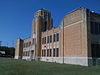
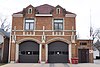
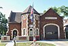
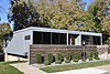
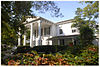
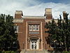
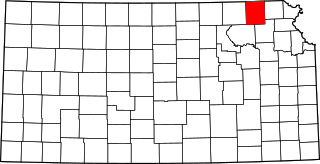
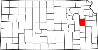
[3] Name on the Register [4] Image Date listed [5] Location City or town Description 1 2209 SW 29th / Dr. Karl & Jeanetta Lyle Menninger Education Center 2209 SW 29th / Dr. Karl & Jeanetta Lyle Menninger Education Center March 26, 2020 (# 100005120 2209 SW 29th St. 39°00′54″N 95°42′19″W / 39.0151°N 95.7052°W / 39.0151; -95.7052 (2209 SW 29th / Dr. Karl & Jeanetta Lyle Menninger Education Center ) Topeka 2 Morton Albaugh House Morton Albaugh House April 28, 2004 (# 04000366 1331 SW. Harrison St. 39°02′31″N 95°40′53″W / 39.0419°N 95.6814°W / 39.0419; -95.6814 (Morton Albaugh House ) Topeka 3 Solomon A. Alt House Solomon A. Alt House March 23, 2005 (# 05000202 1335 SW. College Ave. 39°02′34″N 95°42′01″W / 39.0428°N 95.7003°W / 39.0428; -95.7003 (Solomon A. Alt House ) Topeka 4 Anton-Woodring House Anton-Woodring House August 23, 1991 (# 91001088 1011 Cambridge Ave. 39°03′03″N 95°43′27″W / 39.0508°N 95.7242°W / 39.0508; -95.7242 (Anton-Woodring House ) Topeka 5 ATSF Motive Power Building ATSF Motive Power Building January 20, 2012 (# 11001034 1001 NE Atchison Ave. 39°03′23″N 95°39′27″W / 39.0563°N 95.6575°W / 39.0563; -95.6575 (ATSF Motive Power Building ) Topeka 6 Blacksmith Creek Bridge Blacksmith Creek Bridge March 10, 1983 (# 83000441 West of Topeka 39°03′03″N 95°50′37″W / 39.0507°N 95.8436°W / 39.0507; -95.8436 (Blacksmith Creek Bridge ) Topeka 7 Bowker House Bowker House March 15, 2007 (# 07000139 1200 SE. Quincy 39°02′33″N 95°40′30″W / 39.0425°N 95.675°W / 39.0425; -95.675 (Bowker House ) Topeka 8 Brown v. Board of Education National Historic Site Brown v. Board of Education National Historic Site October 26, 1992 (# 01000156 424 S. Kansas Ave. Suite 220 39°03′15″N 95°40′20″W / 39.0542°N 95.6722°W / 39.0542; -95.6722 (Brown v. Board of Education National Historic Site ) Topeka 9 Shannon Brown House Upload image May 19, 2022 (# 100007707 321 Lakeside Dr. 39°02′29″N 95°43′11″W / 39.0414°N 95.7196°W / 39.0414; -95.7196 (Shannon Brown House ) Topeka 10 Casson Building Casson Building September 14, 2018 (# 100002972 603 SW Topeka Blvd. 39°03′11″N 95°40′45″W / 39.0530°N 95.6792°W / 39.0530; -95.6792 (Casson Building ) Topeka 11 Cedar Crest Cedar Crest May 6, 1982 (# 82002672 Cedar Crest Rd. 39°03′56″N 95°44′44″W / 39.0656°N 95.7456°W / 39.0656; -95.7456 (Cedar Crest ) Topeka 12 Central Motor and Finance Corporation Building Central Motor and Finance Corporation Building February 19, 1982 (# 82002673 222 W. 7th St. 39°03′02″N 95°40′23″W / 39.0506°N 95.6731°W / 39.0506; -95.6731 (Central Motor and Finance Corporation Building ) Topeka 13 Central National Bank Central National Bank July 19, 1976 (# 76000841 701-703 Kansas Ave. 39°03′00″N 95°40′26″W / 39.05°N 95.6739°W / 39.05; -95.6739 (Central National Bank ) Topeka Contributing site of the South Kansas Avenue Commercial Historic District. 14 Church of the Assumption and Rectory Church of the Assumption and Rectory July 2, 2008 (# 08000607 204 SW. 8th St. 39°02′57″N 95°40′34″W / 39.0492°N 95.6761°W / 39.0492; -95.6761 (Church of the Assumption and Rectory ) Topeka 15 Church of the Assumption Historic District Church of the Assumption Historic District July 7, 2015 (# 15000384 204 and 212 SW. 8th Ave. and 735 Jackson St. 39°03′00″N 95°40′34″W / 39.0500°N 95.6761°W / 39.0500; -95.6761 (Church of the Assumption Historic District ) Topeka 16 Church of the Holy Name Church of the Holy Name January 20, 2012 (# 11001035 1110 SW 10th Ave. 39°02′59″N 95°41′25″W / 39.0498°N 95.6904°W / 39.0498; -95.6904 (Church of the Holy Name ) Topeka 17 College Avenue Historic District College Avenue Historic District April 18, 2007 (# 07000321 College Ave. between Huntoon St. and 17th St. 39°02′26″N 95°42′01″W / 39.0405°N 95.7004°W / 39.0405; -95.7004 (College Avenue Historic District ) Topeka 18 Columbian Building Columbian Building September 5, 1975 (# 75000722 112-114 W. 6th St. 39°03′08″N 95°40′26″W / 39.0522°N 95.6739°W / 39.0522; -95.6739 (Columbian Building ) Topeka 19 Constitution Hall-Topeka Constitution Hall-Topeka July 15, 2008 (# 08000669 429 S. Kansas Ave. 39°03′15″N 95°40′20″W / 39.0542°N 95.6722°W / 39.0542; -95.6722 (Constitution Hall-Topeka ) Topeka 20 Country Club Residential Historic District Country Club Residential Historic District August 11, 2022 (# 100007279 Roughly bounded by SW 24th St., SW Topeka Blvd., SW Merriam Ct., and SW Western Ave. 39°01′29″N 95°41′10″W / 39.0248°N 95.6862°W / 39.0248; -95.6862 (Country Club Residential Historic District ) Topeka 21 Crawford Building Crawford Building August 22, 1975 (# 75000723 501 Jackson St. 39°03′12″N 95°40′26″W / 39.0533°N 95.6739°W / 39.0533; -95.6739 (Crawford Building ) Topeka 22 Nelson Antrim Crawford House Nelson Antrim Crawford House October 4, 2017 (# 100001707 2202 SW. 17th St. 39°02′13″N 95°42′18″W / 39.0370°N 95.70512°W / 39.0370; -95.70512 (Nelson Antrim Crawford House ) Topeka 23 William T. and Delora Crosby House William T. and Delora Crosby House October 6, 2011 (# 11000729 1109 SW Topeka Blvd. 39°02′45″N 95°40′58″W / 39.0458°N 95.6828°W / 39.0458; -95.6828 (William T. and Delora Crosby House ) Topeka 24 Curtis Junior High School Curtis Junior High School October 22, 2001 (# 01001126 316 NW. Grant St. 39°04′26″N 95°40′00″W / 39.0738°N 95.6666°W / 39.0738; -95.6666 (Curtis Junior High School ) Topeka 25 Charles Curtis House Charles Curtis House January 25, 1973 (# 73000778 1101 Topeka Ave. 39°02′45″N 95°40′55″W / 39.0458°N 95.6819°W / 39.0458; -95.6819 (Charles Curtis House ) Topeka 26 Davies Building Davies Building September 15, 1977 (# 77000597 725-727 Kansas Ave. 39°02′58″N 95°40′27″W / 39.0494°N 95.6742°W / 39.0494; -95.6742 (Davies Building ) Topeka Contributing site of the South Kansas Avenue Commercial Historic District. 27 Devon Apartments Devon Apartments June 27, 2002 (# 02000683 800-808 W. 12th St. 39°02′46″N 95°41′11″W / 39.0461°N 95.6864°W / 39.0461; -95.6864 (Devon Apartments ) Topeka 28 Dillon House Dillon House December 27, 2006 (# 06001171 404 W. 9th St. 39°02′55″N 95°40′46″W / 39.0486°N 95.6794°W / 39.0486; -95.6794 (Dillon House ) Topeka 29 East Topeka Junior High School East Topeka Junior High School January 14, 2004 (# 03001397 1210 E. 8th St. 39°02′42″N 95°39′36″W / 39.045°N 95.66°W / 39.045; -95.66 (East Topeka Junior High School ) Topeka 30 England Farm England Farm May 7, 1982 (# 82002674 4619 SE. 37th St. 38°59′58″N 95°35′27″W / 38.9994°N 95.5908°W / 38.9994; -95.5908 (England Farm ) Topeka 31 Evergreen Court Apartments Evergreen Court Apartments April 2, 2021 (# 100006326 3311-3321 SW 10th Ave. 39°03′04″N 95°43′10″W / 39.0512°N 95.7194°W / 39.0512; -95.7194 (Evergreen Court Apartments ) Topeka 32 Fire Station No. 1 Fire Station No. 1 December 28, 2020 (# 100005955 934 NE Quincy St. 39°04′06″N 95°39′52″W / 39.0684°N 95.6644°W / 39.0684; -95.6644 (Fire Station No. 1 ) Topeka 33 Fire Station No. 2-Topeka Fire Station No. 2-Topeka July 3, 2002 (# 02000715 719-723 Van Buren 39°03′07″N 95°40′35″W / 39.0519°N 95.6764°W / 39.0519; -95.6764 (Fire Station No. 2-Topeka ) Topeka 34 Fire Station No. 4 Fire Station No. 4 September 30, 2019 (# 100004450 813 SW. Clay St. 39°03′07″N 95°41′21″W / 39.0519°N 95.6891°W / 39.0519; -95.6891 (Fire Station No. 4 ) Topeka 35 Fire Station No. 6 Fire Station No. 6 October 5, 2020 (# 100005631 1419 NE Seward Ave. 39°03′32″N 95°39′03″W / 39.0588°N 95.6507°W / 39.0588; -95.6507 (Fire Station No. 6 ) Topeka 36 Fire Station No. 7 Fire Station No. 7 June 1, 2020 (# 100005119 1215 SW Oakley Ave. 39°02′43″N 95°42′55″W / 39.0453°N 95.7154°W / 39.0453; -95.7154 (Fire Station No. 7 ) Topeka 37 Fool Chief's Village Upload image August 2, 2021 (# 100006772 Address Restricted Menoken vicinity 38 Gem Building Gem Building November 1, 2006 (# 06000964 506-510 SW. 10th Ave. 39°02′58″N 95°40′54″W / 39.0494°N 95.6817°W / 39.0494; -95.6817 (Gem Building ) Topeka 39 Giles-Nellis House Giles-Nellis House April 28, 1992 (# 92000432 915 SW. Munson 39°02′50″N 95°41′15″W / 39.0472°N 95.6875°W / 39.0472; -95.6875 (Giles-Nellis House ) Topeka Contributing site for the Holliday Park Historic District I. 40 Gordon Building Gordon Building October 20, 2010 (# 10000846 900, 902, and 904 S. Kansas Ave. 39°02′49″N 95°40′30″W / 39.047°N 95.675°W / 39.047; -95.675 (Gordon Building ) Topeka Turn-of-the-20th-century classical revival furniture warehouse significant in Topeka's commercial history. [6] Contributing site of the South Kansas Avenue Commercial Historic District. 41 HTK Architects Office Building HTK Architects Office Building June 1, 2021 (# 100006580 2900 SW MacVicar Ave. 39°00′53″N 95°42′22″W / 39.0146°N 95.7062°W / 39.0146; -95.7062 (HTK Architects Office Building ) Topeka 42 Hard Chief's Village Upload image June 22, 2007 (# 07000610 Southern side of the Kansas River , west of its confluence with Mission Creek [7] 39°04′24″N 95°51′40″W / 39.0733°N 95.861°W / 39.0733; -95.861 (Hard Chief's Village ) Silver Lake 43 John C. Harmon House John C. Harmon House January 20, 2012 (# 11001036 915 SW Buchanan 39°03′04″N 95°41′30″W / 39.0512°N 95.6918°W / 39.0512; -95.6918 (John C. Harmon House ) Topeka 44 Hicks Block Hicks Block November 9, 1977 (# 77000598 600 W. 6th Ave. 39°03′14″N 95°40′48″W / 39.0539°N 95.68°W / 39.0539; -95.68 (Hicks Block ) Topeka 45 Holliday Park Historic District I Holliday Park Historic District I November 17, 2002 (# 02001308 Roughly bounded by 10th Ave. and Taylor, Polk, Huntoon, Clay and Fillmore Sts. 39°02′45″N 95°41′12″W / 39.0459°N 95.6866°W / 39.0459; -95.6866 (Holliday Park Historic District I ) Topeka 46 Holliday Park Historic District II Holliday Park Historic District II November 15, 2002 (# 02001309 1009, 1015, 1019,1021,1025, 1031, 1035 SW Fillmore St. 39°02′55″N 95°41′20″W / 39.0485°N 95.6890°W / 39.0485; -95.6890 (Holliday Park Historic District II ) Topeka 47 Hopkins House Hopkins House January 16, 2009 (# 08001353 6033 SE. U.S. Route 40 39°02′39″N 95°33′23″W / 39.0442°N 95.5564°W / 39.0442; -95.5564 (Hopkins House ) Tecumseh 48 House at 116 Southwest The Drive House at 116 Southwest The Drive October 5, 2020 (# 100005633 116 SW The Drive 39°03′45″N 95°41′52″W / 39.0624°N 95.6979°W / 39.0624; -95.6979 (House at 116 Southwest The Drive ) Topeka 49 Hughes Conoco Service Station Hughes Conoco Service Station July 5, 2011 (# 11000411 400 SW. Taylor St. 39°03′25″N 95°40′54″W / 39.0569°N 95.6817°W / 39.0569; -95.6817 (Hughes Conoco Service Station ) Topeka 50 Jayhawk Hotel, Theater and Walk Jayhawk Hotel, Theater and Walk March 11, 1982 (# 82002675 700 Jackson Ave. 39°03′01″N 95°40′29″W / 39.0503°N 95.6747°W / 39.0503; -95.6747 (Jayhawk Hotel, Theater and Walk ) Topeka Contributing site of the South Kansas Avenue Commercial Historic District. 51 Kansas State Capitol Kansas State Capitol September 3, 1971 (# 71000330 Bounded by 8th and 10th Aves. and Jackson and Harrison Sts. 39°02′54″N 95°40′39″W / 39.0483°N 95.6775°W / 39.0483; -95.6775 (Kansas State Capitol ) Topeka 52 Hazen L. Kirkpatrick House Hazen L. Kirkpatrick House July 27, 2023 (# 100009185 1320 Pembroke Ln. 39°02′28″N 95°43′03″W / 39.0411°N 95.7175°W / 39.0411; -95.7175 (Hazen L. Kirkpatrick House ) Topeka 53 Charles and Dorothy Kouns House Charles and Dorothy Kouns House October 5, 2020 (# 100005630 1625 SW MacVicar Ave. 39°02′15″N 95°42′22″W / 39.0376°N 95.7062°W / 39.0376; -95.7062 (Charles and Dorothy Kouns House ) Topeka 54 James and Freda Lippitt House James and Freda Lippitt House October 5, 2020 (# 100005634 2532 SW Granthurst Ave. 39°01′27″N 95°41′10″W / 39.0243°N 95.6862°W / 39.0243; -95.6862 (James and Freda Lippitt House ) Topeka 55 Fred and Cora Luttjohann House Fred and Cora Luttjohann House February 20, 2004 (# 03001384 2053 S. Kansas Ave. 39°01′53″N 95°40′45″W / 39.0314°N 95.6793°W / 39.0314; -95.6793 (Fred and Cora Luttjohann House ) Topeka 56 Horace G. Lyons House Horace G. Lyons House August 1, 1984 (# 84001241 4831 SE. 61st St. 38°57′21″N 95°35′02″W / 38.9558°N 95.5839°W / 38.9558; -95.5839 (Horace G. Lyons House ) Berryton 57 Masonic Grand Lodge Building Masonic Grand Lodge Building October 8, 2014 (# 14000833 320 SW. 8th Ave. 39°03′00″N 95°40′42″W / 39.0501°N 95.6784°W / 39.0501; -95.6784 (Masonic Grand Lodge Building ) Topeka 58 McCauley Bridge McCauley Bridge July 2, 1985 (# 85001427 0.5 miles south of Auburn 38°53′49″N 95°48′53″W / 38.8969°N 95.8147°W / 38.8969; -95.8147 (McCauley Bridge ) Auburn 59 Memorial Building Memorial Building July 17, 1975 (# 75000724 120 W. 10th Ave. 39°02′47″N 95°40′34″W / 39.0464°N 95.6761°W / 39.0464; -95.6761 (Memorial Building ) Topeka Contributing site of the South Kansas Avenue Commercial Historic District. 60 Menninger Clinic Building Menninger Clinic Building February 13, 1975 (# 75000725 3535 W. 6th Ave. 39°03′30″N 95°43′14″W / 39.0583°N 95.7206°W / 39.0583; -95.7206 (Menninger Clinic Building ) Topeka 61 Mill Block Historic District Mill Block Historic District July 7, 2015 (# 15000385 101-129 N. Kansas Ave. 39°03′34″N 95°40′14″W / 39.0595°N 95.6705°W / 39.0595; -95.6705 (Mill Block Historic District ) Topeka 62 Morgan House Morgan House April 28, 2004 (# 04000367 1335 SW. Harrison St. 39°02′30″N 95°40′53″W / 39.0417°N 95.6814°W / 39.0417; -95.6814 (Morgan House ) Topeka 63 North Topeka Baptist Church North Topeka Baptist Church January 18, 2011 (# 10001137 123 NW Gordon. 39°04′09″N 95°39′59″W / 39.0692°N 95.6664°W / 39.0692; -95.6664 (North Topeka Baptist Church ) Topeka 64 Old German-American State Bank Old German-American State Bank April 30, 1980 (# 80001475 435 Kansas Ave. 39°03′12″N 95°40′22″W / 39.0534°N 95.6729°W / 39.0534; -95.6729 (Old German-American State Bank ) Topeka 65 Park Plaza Apartments Park Plaza Apartments June 1, 2021 (# 100006579 1275 SW Fillmore St. 39°02′34″N 95°41′22″W / 39.0429°N 95.6894°W / 39.0429; -95.6894 (Park Plaza Apartments ) Topeka 66 Pottawatomie Baptist Mission Building Pottawatomie Baptist Mission Building September 3, 1971 (# 71001089 Off W. 6th St., 0.5 mile west of Wanamaker Rd.; also on Urish Rd., 0.3 miles north of 10th St. 39°03′21″N 95°46′31″W / 39.0558°N 95.7753°W / 39.0558; -95.7753 (Pottawatomie Baptist Mission Building ) Topeka Urish Road location represents a boundary increase 67 Potwin Place Historic District Potwin Place Historic District May 1, 1980 (# 80001476 Roughly bounded by Elmwood, Grove, Broadmoor, and Willow Sts. 39°03′43″N 95°41′38″W / 39.0619°N 95.6939°W / 39.0619; -95.6939 (Potwin Place Historic District ) Topeka 68 Ritchie Cemetery Ritchie Cemetery January 4, 2023 (# 100008523 1900-1948 SW 27th St. 39°01′21″N 95°42′08″W / 39.0225°N 95.7023°W / 39.0225; -95.7023 (Ritchie Cemetery ) Topeka 69 John and Mary Ritchie House John and Mary Ritchie House December 29, 2015 (# 15000939 1116 SE. Madison St. 39°02′34″N 95°40′21″W / 39.0427°N 95.6724°W / 39.0427; -95.6724 (John and Mary Ritchie House ) Topeka 70 Ross Row Houses Ross Row Houses November 5, 1998 (# 98001329 513, 515, 517, 517½, 519, and 521 Van Buren St. 39°03′12″N 95°40′34″W / 39.0533°N 95.676°W / 39.0533; -95.676 (Ross Row Houses ) Topeka 71 Sage Inn Sage Inn October 8, 1976 (# 76000840 57th St. and Douglas Rd. 38°57′53″N 95°56′17″W / 38.9647°N 95.9381°W / 38.9647; -95.9381 (Sage Inn ) Dover 72 St. John African Methodist Episcopal Church St. John African Methodist Episcopal Church August 16, 2008 (# 08000987 701 SW. Topeka Boulevard 39°03′06″N 95°40′47″W / 39.0517°N 95.6797°W / 39.0517; -95.6797 (St. John African Methodist Episcopal Church ) Topeka 73 St. John's Lutheran School St. John's Lutheran School January 3, 1985 (# 85000014 315 W. 4th St. 39°03′19″N 95°40′32″W / 39.0553°N 95.6756°W / 39.0553; -95.6756 (St. John's Lutheran School ) Topeka 74 St. Joseph's Catholic Church St. Joseph's Catholic Church February 24, 1971 (# 71000331 235 Van Buren St. 39°03′24″N 95°40′29″W / 39.056667°N 95.674722°W / 39.056667; -95.674722 (St. Joseph's Catholic Church ) Topeka 75 St. Joseph's School-St. Joseph's Convent St. Joseph's School-St. Joseph's Convent March 14, 2019 (# 100003441 304-308 SW Van Buren St. 39°03′23″N 95°40′28″W / 39.0564°N 95.6745°W / 39.0564; -95.6745 (St. Joseph's School-St. Joseph's Convent ) Topeka 76 St. Mark's African Methodist Episcopal Church St. Mark's African Methodist Episcopal Church March 14, 2019 (# 100004451 801 NW. Harrison Ave. 39°04′04″N 95°40′16″W / 39.0679°N 95.6711°W / 39.0679; -95.6711 (St. Mark's African Methodist Episcopal Church ) Topeka 77 Santa Fe Hospital Santa Fe Hospital October 11, 2016 (# 16000708 600 SE Madison St. 39°03′01″N 95°40′09″W / 39.050183°N 95.669217°W / 39.050183; -95.669217 (Santa Fe Hospital ) Topeka 78 John Sargent House John Sargent House July 28, 1995 (# 95000930 225 SW. Clay St. 39°03′38″N 95°41′08″W / 39.060556°N 95.685556°W / 39.060556; -95.685556 (John Sargent House ) Topeka 79 Security Benefit Association Hospital Building Security Benefit Association Hospital Building November 30, 2005 (# 05001341 5800 SW. 6th, 5 miles northwest on private road 39°03′45″N 95°45′27″W / 39.0625°N 95.7575°W / 39.0625; -95.7575 (Security Benefit Association Hospital Building ) Topeka 80 Senate and Curtis Court Apartments Historic District Senate and Curtis Court Apartments Historic District December 29, 2015 (# 15000940 900-914 SW. Tyler St. 39°02′56″N 95°40′57″W / 39.048832°N 95.682510°W / 39.048832; -95.682510 (Senate and Curtis Court Apartments Historic District ) Topeka 81 Shiloh Baptist Church Shiloh Baptist Church June 29, 2018 (# 100002629 1201 SW Buchanan St. 39°02′45″N 95°41′33″W / 39.0457°N 95.6924°W / 39.0457; -95.6924 (Shiloh Baptist Church ) Topeka 82 J.A. Shoemaker House J.A. Shoemaker House January 22, 2009 (# 08001354 1434 SW. Plass Ave. 39°02′27″N 95°42′17″W / 39.040808°N 95.704619°W / 39.040808; -95.704619 (J.A. Shoemaker House ) Topeka 83 South Kansas Avenue Commercial Historic District South Kansas Avenue Commercial Historic District July 7, 2015 (# 15000386 Roughly bounded by 6th and 10th Aves. and SW. Jackson and SE. Quincy Sts. 39°02′56″N 95°40′29″W / 39.0489°N 95.6746°W / 39.0489; -95.6746 (South Kansas Avenue Commercial Historic District ) Topeka 84 Sumner Elementary School and Monroe Elementary School Sumner Elementary School and Monroe Elementary School May 4, 1987 (# 87001283 330 Western Ave. and 1515 Monroe St. 39°03′29″N 95°40′56″W / 39.058056°N 95.682222°W / 39.058056; -95.682222 (Sumner Elementary School and Monroe Elementary School ) Topeka 85 Thacher Building Thacher Building March 31, 1975 (# 75000726 110 E. 8th St. 39°02′56″N 95°40′24″W / 39.048889°N 95.673333°W / 39.048889; -95.673333 (Thacher Building ) Topeka Contributing site of the South Kansas Avenue Commercial Historic District 86 Thomas Arch Bridge Thomas Arch Bridge May 10, 1990 (# 90000746 Junction of Wanamaker Rd. and 105th St. across the Wakarusa River 38°52′30″N 95°45′41″W / 38.875°N 95.761389°W / 38.875; -95.761389 (Thomas Arch Bridge ) Auburn 87 Topeka Cemetery Historic District Topeka Cemetery Historic District April 25, 2001 (# 01000409 1601 E. 10th St. 39°02′30″N 95°39′17″W / 39.041667°N 95.654722°W / 39.041667; -95.654722 (Topeka Cemetery Historic District ) Topeka Boundary increase and renaming October 4, 2017 . 88 Topeka Council of Colored Women's Clubs Building Topeka Council of Colored Women's Clubs Building December 30, 2009 (# 09001169 1149 SW. Lincoln 39°02′51″N 95°41′38″W / 39.047633°N 95.694008°W / 39.047633; -95.694008 (Topeka Council of Colored Women's Clubs Building ) Topeka 89 Topeka High School Topeka High School June 9, 2005 (# 05000550 800 SW. 10th Ave. 39°03′03″N 95°41′08″W / 39.050833°N 95.685556°W / 39.050833; -95.685556 (Topeka High School ) Topeka 90 Topeka Veterans Administration Hospital Topeka Veterans Administration Hospital March 7, 2019 (# 100003485 2200 SW Gage Blvd. 39°01′35″N 95°43′25″W / 39.0263°N 95.7236°W / 39.0263; -95.7236 (Topeka Veterans Administration Hospital ) Topeka 91 Union Church Building Union Church Building January 5, 2024 (# 100009708 760 North Washington Street 38°54′21″N 95°48′59″W / 38.9058°N 95.8164°W / 38.9058; -95.8164 (Union Church Building ) Auburn 92 Union Pacific Railroad Passenger Depot Union Pacific Railroad Passenger Depot October 1, 2002 (# 02000492 701 N. Kansas Ave. 39°03′58″N 95°40′10″W / 39.066111°N 95.669444°W / 39.066111; -95.669444 (Union Pacific Railroad Passenger Depot ) Topeka 93 Uniontown Cemetery Uniontown Cemetery May 17, 2010 (# 10000263 NW Douglas Rd. 39°05′05″N 95°56′15″W / 39.084661°N 95.937522°W / 39.084661; -95.937522 (Uniontown Cemetery ) Willard 94 United States Post Office and Court House United States Post Office and Court House March 3, 2015 (# 15000046 424 S. Kansas Ave. 39°03′13″N 95°40′21″W / 39.0535°N 95.6724°W / 39.0535; -95.6724 (United States Post Office and Court House ) Topeka 95 Tinkham Veale Building Tinkham Veale Building January 11, 2006 (# 05001511 909-911 S. Kansas Ave. 39°02′49″N 95°40′32″W / 39.046944°N 95.675556°W / 39.046944; -95.675556 (Tinkham Veale Building ) Topeka Contributing site of the South Kansas Avenue Commercial Historic District 96 Wakarusa Hotel Wakarusa Hotel April 26, 1979 (# 79000955 Main St. 38°53′05″N 95°41′46″W / 38.884722°N 95.696111°W / 38.884722; -95.696111 (Wakarusa Hotel ) Wakarusa 97 Ward-Meade House Ward-Meade House November 12, 1975 (# 75000727 124 N. Fillmore 39°03′49″N 95°40′54″W / 39.063611°N 95.681667°W / 39.063611; -95.681667 (Ward-Meade House ) Topeka 98 Washburn University Carnegie Library Building Washburn University Carnegie Library Building June 25, 1987 (# 87000972 Off 17th St. and Washburn Ave. 39°02′08″N 95°42′03″W / 39.035556°N 95.700833°W / 39.035556; -95.700833 (Washburn University Carnegie Library Building ) Topeka 99 Wea Creek Bowstring Arch Truss Bridge Wea Creek Bowstring Arch Truss Bridge May 9, 2003 (# 03000363 Grounds of the Kansas State Historical Society, 6425 SE. 6th Ave. 39°03′21″N 95°46′40″W / 39.055833°N 95.777778°W / 39.055833; -95.777778 (Wea Creek Bowstring Arch Truss Bridge ) Topeka 100 Westminster Presbyterian Church Westminster Presbyterian Church May 19, 2004 (# 04000453 1275 Boswell Ave. 39°02′37″N 95°42′08″W / 39.043611°N 95.702222°W / 39.043611; -95.702222 (Westminster Presbyterian Church ) Topeka 101 Willits House Willits House June 2, 1997 (# 97000463 1035 SW. Fillmore 39°02′53″N 95°41′27″W / 39.048056°N 95.690833°W / 39.048056; -95.690833 (Willits House ) Topeka Contributing site of the Holliday Park Historic District II. 102 Woman's Club Building Woman's Club Building February 19, 1982 (# 82002676 420 W. 9th St. 39°02′45″N 95°40′32″W / 39.045833°N 95.675556°W / 39.045833; -95.675556 (Woman's Club Building ) Topeka 103 Chester B. Woodward House Chester B. Woodward House June 25, 1992 (# 92000817 1272 SW. Fillmore St. 39°02′36″N 95°41′17″W / 39.043333°N 95.688056°W / 39.043333; -95.688056 (Chester B. Woodward House ) Topeka