Current listings
| [4] | Name on the Register [5] | Image | Date listed [6] | Location | Description |
|---|---|---|---|---|---|
| 1 | Agudath Sholem Synagogue |  | May 11, 1995 (#95000561) | 29 Grove St., in downtown Stamford [7] : 3 41°03′18″N73°32′01″W / 41.055°N 73.5336°W | The congregation's second synagogue, now a church, completed in the Romanesque Revival style. The congregation worships in its third synagogue building (not listed). |
| 2 | Church of the Holy Name |  | December 24, 1987 (#87002131) | 325 Washington Blvd., in the South End 41°02′41″N73°32′34″W / 41.0447°N 73.5428°W | |
| 3 | Cove Island Houses |  | May 22, 1979 (#79002652) | Cove Rd. and Weed Ave., in Cove Island Park (southeastern Stamford) [8] : 3 41°02′56″N73°29′59″W / 41.0489°N 73.4997°W | Although plural in name, this is a single house in Stamford, Connecticut that was expanded from a first section that dates from 1791. Now predominantly a Georgian style house with a newer Federal style wing, it is the only remainder of the large Stamford Mills complex at the Cove. [9] |
| 4 | Deacon John Davenport House |  | April 29, 1982 (#82004611) | 129 Davenport Ridge Rd., in North Stamford [10] : 2 41°07′31″N73°31′38″W / 41.1253°N 73.5272°W | A saltbox house built in 1775 with Federal style features added later, significant for its architecture and for its association with the Davenport family. [11] |
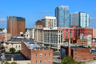
| 5 | Downtown Stamford Historic District |  | October 6, 1983 (#83003502) | Atlantic, Main, Bank, and Bedford Sts.; also bounded by Atlantic, Main, Bank, Bedford, Summer between Broad and Main Sts. and Summer Pl.; also roughly Bedford St. between Broad and Forest Sts. 41°03′57″N73°32′26″W / 41.0658°N 73.5405°W | A historic district which first included the largest remaining area of pre-1930s commercial and institutional buildings in downtown Stamford. [12] Its boundaries were expanded in 1985 to capture the only surviving area in downtown of lower-rent commercial structures such as warehouses, laundries, and stables. [13] and in 2002 to add the 1939-built Avon Theatre and buildings of Late Gothic Revival and Art Deco architectural styles. [14] |
| 6 | First Presbyterian Church |  | January 13, 2021 (#100006271) | 1101 Bedford Street 41°03′47″N73°32′19″W / 41.063°N 73.5385°W | Aka the Fish Church |
| 7 | Fort Stamford Site |  | September 10, 1975 (#75001920) | 900 Westover Rd. [15] 41°05′06″N73°34′42″W / 41.0849°N 73.5783°W | Now a city park. |
| 8 | Graham House |  | September 13, 2011 (#11000609) | Address Restricted | |
| 9 | Benjamin Hait House |  | November 30, 1978 (#78002844) | 92 Hoyclo Rd., in North Stamford [16] : 4 41°08′54″N73°33′07″W / 41.1483°N 73.5519°W | Built between 1728 and 1735; the oldest house in the area; a rare example of a New England farmhouse amidst a now-suburban area. [17] |
| 10 | Hoyt-Barnum House | 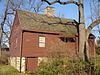 | June 11, 1969 (#69000199) | 1508 High Ridge Rd. 41°07′21″N73°32′41″W / 41.1225°N 73.5447°W | Built around 1699, a timber frame construction or post and beam farmhouse made of field stone, laid up with clay, animal hair, and straw. The house is braced timber frame construction or post and beam. [18] [19] The house was moved to High Ridge Road in 2017. |
| 11 | Hubbard Heights Historic District |  | October 18, 2016 (#16000724) | Hubbard Ave. and vicinity 41°03′40″N73°33′10″W / 41.0610°N 73.5527°W | |
| 12 | John Knap House |  | March 5, 1979 (#79002625) | 984 Stillwater Rd. 41°04′35″N73°33′26″W / 41.0764°N 73.5572°W | Built c. 1705 by a Capt. John Knap, and owned by his son, Lt. John Knap, and then grandson Samuel Knap in 1765. Believed to be the second oldest house in Stamford. [20] : 7 |
| 13 | Linden Apartments |  | August 11, 1983 (#83001252) | 10-12 Linden Pl. 41°03′36″N73°32′42″W / 41.06°N 73.545°W | Second Empire style building built in 1886; the oldest six-unit tenement apartment building in Stamford [21] |
| 14 | Long Ridge Village Historic District | 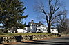 | June 2, 1987 (#86003653) | Old Long Ridge Rd. bounded by the New York State Line, Rock Rimmon Rd., and Long Ridge Rd./CT 104 Boundary increase (listed October 20, 2011): 1-130 Mill Rd., 189-247 Old Long Ridge Rd., 1257-1306 Rock Rimmon Rd. 41°09′20″N73°35′37″W / 41.1556°N 73.5936°W | |
| 15 | Main Street Bridge |  | May 21, 1987 (#87000801) | Carries Main St. over the Rippowam River in downtown Stamford [22] : 7 41°03′08″N73°32′44″W / 41.0522°N 73.5456°W | "Connecticut's only wrought-iron lenticular truss remaining on a major artery in an urban center" and one of only 17 pony truss bridges in the state, built by the Berlin Iron Bridge Company [23] |
| 16 | Marion Castle, Terre Bonne |  | July 1, 1982 (#82004341) | 1 Rogers Rd., in the Shippan Point neighborhood [24] : 2 41°01′23″N73°31′45″W / 41.0231°N 73.5292°W | |
| 17 | Merritt Parkway |  | April 17, 1991 (#91000410) | Route 15 right-of-way between the New York state line and the Sikorsky Memorial Bridge; also located in Greenwich, New Canaan, Norwalk, Westport, Fairfield, Trumbull, and Stratford 41°06′30″N73°33′20″W / 41.1083°N 73.5556°W | Listing includes bridges crossing and bridges carrying the historic parkway. |
| 18 | Octagon House |  | August 17, 1979 (#79002624) | 120 Strawberry Hill Ave. 41°03′50″N73°32′07″W / 41.0639°N 73.5353°W | Demolished. |
| 19 | Old Town Hall |  | June 2, 1972 (#72001304) | Junction of Atlantic, Bank, and Main Sts., in downtown Stamford [25] : 3 41°03′11″N73°32′26″W / 41.0531°N 73.5406°W | |
| 20 | Gustavus and Sarah T. Pike House |  | May 24, 1990 (#90000759) | 164 Fairfield Ave. 41°02′46″N73°33′03″W / 41.0462°N 73.5508°W | Queen Anne style house built in 1880 that is an excellent example of pattern book application. It includes machine-made spindles and other detailing that had only recently became cost-effective with then-modern manufacturing. [26] |
| 21 | Revonah Manor Historic District |  | July 31, 1986 (#86002100) | Roughly bounded by Urban St., East Ave., Fifth, and Bedford Sts. 41°04′04″N73°32′29″W / 41.0678°N 73.5414°W | |
| 22 | Rockrimmon Rockshelter |  | August 5, 1994 (#94000847) | Address Restricted | An archeological site entered on a boulder about 60 feet high that was used as a shelter by early Native Americans. |
| 23 | St. Andrew's Protestant Episcopal Church |  | December 6, 1983 (#83003510) | 1231 Washington Blvd. in downtown Stamford [27] 41°03′26″N73°32′32″W / 41.057222°N 73.542222°W | |
| 24 | St. Benedict's Church |  | December 24, 1987 (#87002130) | 1A St. Benedict's Circle 41°02′55″N73°31′14″W / 41.048722°N 73.520694°W | |
| 25 | St. John's Protestant Episcopal Church |  | December 24, 1987 (#87002128) | 628 Main St. in downtown Stamford [27] 41°03′17″N73°32′02″W / 41.054722°N 73.533889°W | A historic church that was built in 1869. |
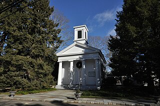
| 26 | St. Luke's Chapel |  | December 24, 1987 (#87002129) | 714 Pacific St., in the South End Historic District [28] 41°02′34″N73°32′16″W / 41.042778°N 73.537778°W | |
| 27 | St. Mary's Church |  | December 24, 1987 (#87002123) | 540 Elm St. 41°02′59″N73°31′29″W / 41.049611°N 73.52475°W | A Roman Catholic church. |
| 28 | South End Historic District | 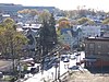 | March 19, 1986 (#86000472) | Roughly bounded by Metro-North railroad tracks, Stamford Canal, Woodland Cemetery, and Washington Blvd. 41°02′36″N73°32′16″W / 41.043417°N 73.537861°W | Historic district that includes 449 buildings, most dating from the 1870s to the 1930s, and also "an early naturalistic cemetery, and an iron bridge." [29] |
| 29 | Stamford Harbor Lighthouse | 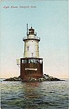 | April 3, 1991 (#91000348) | South of breakwater, Stamford Harbor 41°00′49″N73°32′35″W / 41.013611°N 73.543056°W | |
| 30 | C. J. Starr Barn and Carriage House |  | September 14, 1979 (#79002623) | 200 Strawberry Hill Ave. 41°04′03″N73°32′06″W / 41.0675°N 73.535°W | |
| 31 | Suburban Club |  | August 10, 1989 (#89001090) | 6 Suburban Ave./580 Main St., in downtown Stamford [30] : 2 41°03′16″N73°32′08″W / 41.054444°N 73.535556°W | |
| 32 | Turn-of-River Bridge |  | July 31, 1987 (#87000798) | Old North Stamford Road at Rippowam River in northern Stamford [31] : 2 41°06′54″N73°32′42″W / 41.115°N 73.545°W | A lenticular pony truss bridge built by the Berlin Iron Bridge Company in 1892, using a design patented by William O. Douglas in 1878 for a lens-type truss bridge. It brings the Old Stamford Road across Rippowam River. [32] |
| 33 | Unitarian-Universalist Church |  | December 24, 1987 (#87002126) | 20 Forest St. in downtown Stamford [27] 41°03′27″N73°32′14″W / 41.0575°N 73.537222°W | |
| 34 | US Post Office-Stamford Main |  | December 12, 1985 (#85003328) | 421 Atlantic St. 41°02′59″N73°32′22″W / 41.049722°N 73.539444°W | |
| 35 | Zion Lutheran Church |  | December 24, 1987 (#87002127) | 132 Glenbrook Rd. 41°03′35″N73°31′39″W / 41.059722°N 73.5275°W | A "fine example of ecclesiastical Neo-Gothic architecture", built of red brick. [33] |