National Register of Historic Places listings in Stephenson County, Illinois

Last updated

Location of Stephenson County in Illinois Map of Illinois highlighting Stephenson County.svg
Location of Stephenson County in Illinois

This is a list of the National Register of Historic Places listings in Stephenson County, Illinois.

Contents

This is intended to be a complete list of the properties and districts on the National Register of Historic Places in Stephenson County, Illinois, United States. Latitude and longitude coordinates are provided for many National Register properties and districts; these locations may be seen together in a map. [1]

There are 16 properties and districts listed on the National Register in the county, and two former listings.


    This National Park Service list is complete through NPS recent listings posted December 8, 2023. [2]

Map all coordinates using: OpenStreetMap

Current listings

[3] Name on the RegisterImageDate listed [4] Location City or townDescription
1 John H. Addams Homestead
John H. Addams Homestead Cedarville Il Addams Homestead5.jpg
John H. Addams Homestead
April 17, 1979
(#79000871)
425 N. Mill St.
42°23′26″N89°38′16″W / 42.390556°N 89.637778°W / 42.390556; -89.637778 (John H. Addams Homestead)
Cedarville
2 AF and AM Lodge 687, Orangeville
AF and AM Lodge 687, Orangeville Orangeville Il AF and AM Lodge3.jpg
AF and AM Lodge 687, Orangeville
May 9, 2003
(#03000354)
203 W. High St.
42°28′06″N89°38′44″W / 42.468333°N 89.645556°W / 42.468333; -89.645556 (AF and AM Lodge 687, Orangeville)
Orangeville
3 James Bruce Round Barn
James Bruce Round Barn Freeport Il Bruce Round Barn7.JPG
James Bruce Round Barn
February 23, 1984
(#84001157)
S of Freeport
42°15′07″N89°38′57″W / 42.251944°N 89.649167°W / 42.251944; -89.649167 (James Bruce Round Barn)
Freeport
4 Central House
Central House Orangeville Il Central House1.JPG
Central House
May 20, 1999
(#99000585)
210 W. High St.
42°28′09″N89°38′47″W / 42.469167°N 89.646389°W / 42.469167; -89.646389 (Central House)
Orangeville
5 Charles Fehr Round Barn
Charles Fehr Round Barn Orangeville Il Fehr Round Barn2.jpg
Charles Fehr Round Barn
February 23, 1984
(#84001152)
NE of Orangeville
42°29′46″N89°31′20″W / 42.496111°N 89.522222°W / 42.496111; -89.522222 (Charles Fehr Round Barn)
Orangeville
6 Gerald Harbach Round Barn
Gerald Harbach Round Barn Eleroy Il Harbach Round Barn4.JPG
Gerald Harbach Round Barn
February 23, 1984
(#84001155)
US 20
42°19′40″N89°44′04″W / 42.327778°N 89.734444°W / 42.327778; -89.734444 (Gerald Harbach Round Barn)
Eleroy
7 Chris Jensen Round Barn February 23, 1984
(#84001150)
11723 W. Galena Rd.
42°23′30″N89°50′06″W / 42.391667°N 89.835°W / 42.391667; -89.835 (Chris Jensen Round Barn)
Lena Demolished [5]
8 Kellogg's Grove
Kellogg's Grove Kent Il Kellogg's Grove5.JPG
Kellogg's Grove
June 23, 1978
(#78001191)
SE of Kent
42°17′46″N89°53′13″W / 42.296111°N 89.886944°W / 42.296111; -89.886944 (Kellogg's Grove)
Kent
9 Lena Water Tower
Lena Water Tower Lena Water Tower16.JPG
Lena Water Tower
February 20, 1997
(#97000034)
201 Vernon St.
42°22′49″N89°49′41″W / 42.380278°N 89.828056°W / 42.380278; -89.828056 (Lena Water Tower)
Lena
10 Dennis Otte Round Barn
Dennis Otte Round Barn Eleroy Il Otte Round Barn6.JPG
Dennis Otte Round Barn
February 23, 1984
(#84001164)
E of Eleroy
42°20′01″N89°44′16″W / 42.333611°N 89.737778°W / 42.333611; -89.737778 (Dennis Otte Round Barn)
Eleroy
11 People's State Bank
People's State Bank Orangeville Il People's State Bank5.JPG
People's State Bank
August 20, 2004
(#04000868)
300 W. High St.
42°28′15″N89°38′49″W / 42.470833°N 89.646944°W / 42.470833; -89.646944 (People's State Bank)
Orangeville
12 William Ritzman House
William Ritzman House Orangeville Il Ritzman House1.JPG
William Ritzman House
October 27, 2000
(#00000949)
10715 IL 26 N
42°27′33″N89°38′30″W / 42.459167°N 89.641667°W / 42.459167; -89.641667 (William Ritzman House)
Orangeville
13 Soldiers' Monument
Soldiers' Monument Freeport Il Soldier's Monument8.JPG
Soldiers' Monument
June 1, 1998
(#98000461)
15 N. Galena Ave.
42°17′52″N89°37′19″W / 42.297778°N 89.621944°W / 42.297778; -89.621944 (Soldiers' Monument)
Freeport
14 Stephenson County Courthouse
Stephenson County Courthouse Stephenson County Courthouse.jpg
Stephenson County Courthouse
January 17, 1974
(#74002284)
Courthouse Sq.
42°17′53″N89°37′19″W / 42.298056°N 89.621944°W / 42.298056; -89.621944 (Stephenson County Courthouse)
Freeport Demolished; the building shown is the new courthouse, which was built on the site of the old one[ citation needed ]
15 Oscar Taylor House
Oscar Taylor House Freeport Il Taylor House4.JPG
Oscar Taylor House
May 11, 1984
(#84001165)
1440 S. Carroll Ave.
42°17′04″N89°36′54″W / 42.284444°N 89.615°W / 42.284444; -89.615 (Oscar Taylor House)
Freeport
16 Union House
Union House Orangeville Il Union House3.JPG
Union House
May 11, 2000
(#00000472)
207 W. High St.
42°28′06″N89°38′45″W / 42.468333°N 89.645833°W / 42.468333; -89.645833 (Union House)
Orangeville

Former listing

[3] Name on the RegisterImageDate listedDate removedLocationCity or townDescription
1 Clyde Leek Round Barn February 23, 1984
(#84001161)
December 8, 1995N Dakota Rd.
Dakota
2 Freeport City Hall
Freeport City Hall Freeport Il City Hall4.JPG
Freeport City Hall
June 7, 2016
(#16000329)
January 2, 2020230 W. Stephenson St.
42°17′51″N89°37′24″W / 42.297495°N 89.623231°W / 42.297495; -89.623231 (Freeport City Hall)
Freeport

See also

Related Research Articles

<span class="mw-page-title-main">National Register of Historic Places listings in DuPage County, Illinois</span>

This is a list of the National Register of Historic Places listings in DuPage County, Illinois.

<span class="mw-page-title-main">National Register of Historic Places listings in Winnebago County, Illinois</span>

This is a list of the National Register of Historic Places listings in Winnebago County, Illinois.

<span class="mw-page-title-main">National Register of Historic Places listings in Marion County, Illinois</span>

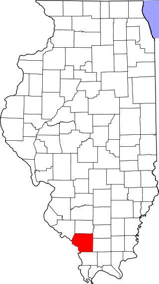
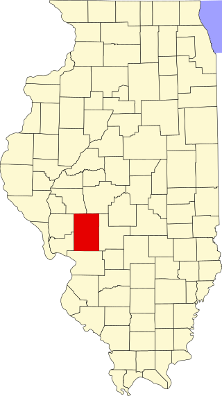
This is a list of the National Register of Historic Places listings in Marion County, Illinois.

<span class="mw-page-title-main">National Register of Historic Places listings in Sangamon County, Illinois</span>

This is a list of the National Register of Historic Places listings in Sangamon County, Illinois.

<span class="mw-page-title-main">National Register of Historic Places listings in Champaign County, Illinois</span>

This is intended to be a complete list of the properties and districts on the National Register of Historic Places in Champaign County, Illinois, United States. Latitude and longitude coordinates are provided for many National Register properties and districts; these locations may be seen together in a map.

<span class="mw-page-title-main">National Register of Historic Places listings in Rock Island County, Illinois</span>

This is a list of the National Register of Historic Places listings in Rock Island County, Illinois.

<span class="mw-page-title-main">National Register of Historic Places listings in Pike County, Illinois</span>

This is a list of the National Register of Historic Places listings in Pike County, Illinois.

<span class="mw-page-title-main">National Register of Historic Places listings in Henry County, Illinois</span>

This is a list of the National Register of Historic Places listings in Henry County, Illinois.

<span class="mw-page-title-main">National Register of Historic Places listings in Jackson County, Illinois</span>

This is a list of the National Register of Historic Places listings in Jackson County, Illinois.

<span class="mw-page-title-main">National Register of Historic Places listings in Livingston County, Illinois</span>

This is a list of the National Register of Historic Places listings in Livingston County, Illinois.

<span class="mw-page-title-main">National Register of Historic Places listings in Logan County, Illinois</span>

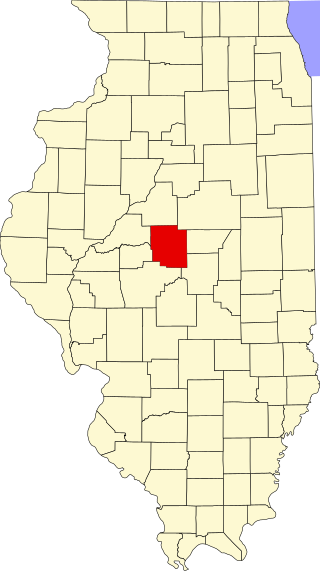
This is a list of the National Register of Historic Places listings in Logan County, Illinois.

<span class="mw-page-title-main">National Register of Historic Places listings in Lee County, Illinois</span>

This is a list of the National Register of Historic Places listings in Lee County, Illinois.

<span class="mw-page-title-main">National Register of Historic Places listings in Warren County, Illinois</span>

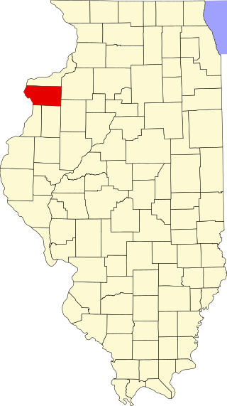
This is a list of the National Register of Historic Places listings in Warren County, Illinois.

<span class="mw-page-title-main">National Register of Historic Places listings in Mercer County, Illinois</span>

This is a list of the National Register of Historic Places listings in Mercer County, Illinois.

<span class="mw-page-title-main">National Register of Historic Places listings in Clark County, Illinois</span>

This is a list of the National Register of Historic Places listings in Clark County, Illinois.

<span class="mw-page-title-main">National Register of Historic Places listings in Monroe County, Illinois</span>

This is a list of the National Register of Historic Places listings in Monroe County, Illinois.

<span class="mw-page-title-main">National Register of Historic Places listings in Carroll County, Illinois</span>

This is a list of the National Register of Historic Places listings in Carroll County, Illinois.

<span class="mw-page-title-main">National Register of Historic Places listings in Macoupin County, Illinois</span>

This is a list of the National Register of Historic Places listings in Macoupin County, Illinois.

<span class="mw-page-title-main">National Register of Historic Places listings in Knox County, Illinois</span>

This is a list of the National Register of Historic Places listings in Knox County, Illinois.

<span class="mw-page-title-main">National Register of Historic Places listings in Grundy County, Illinois</span>

This is a list of the National Register of Historic Places listings in Grundy County, Illinois.

References

  1. The latitude and longitude information provided in this table was derived originally from the National Register Information System, which has been found to be fairly accurate for about 99% of listings. Some locations in this table may have been corrected to current GPS standards.
  2. National Park Service, United States Department of the Interior, "National Register of Historic Places: Weekly List Actions", retrieved December 8, 2023.
  3. 1 2 Numbers represent an alphabetical ordering by significant words. Various colorings, defined here, differentiate National Historic Landmarks and historic districts from other NRHP buildings, structures, sites or objects.
  4. The eight-digit number below each date is the number assigned to each location in the National Register Information System database, which can be viewed by clicking the number.
  5. Travis, Dale. "Illinois Round Barns List" . Retrieved June 18, 2015.