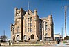
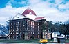
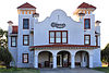
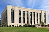
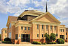
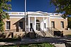
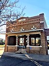
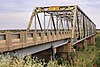
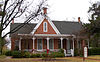
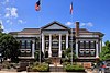
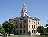
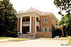
[2] Name on the Register Image Date listed [3] Location City or town Description 1 1915 Taylor County Courthouse 1915 Taylor County Courthouse March 23, 1992 (# 92000225 301 Oak St. 32°26′45″N 99°43′55″W / 32.445972°N 99.732014°W / 32.445972; -99.732014 (1915 Taylor County Courthouse ) Abilene State Antiquities Landmark 2 Abilene and Northern Railway Company Depot Abilene and Northern Railway Company Depot May 28, 2004 (# 92000191 189 Locust St. 32°26′51″N 99°43′47″W / 32.447431°N 99.729722°W / 32.447431; -99.729722 (Abilene and Northern Railway Company Depot ) Abilene 3 Abilene Christian College Administration Building Abilene Christian College Administration Building March 23, 1992 (# 92000193 Campus Court Dr., Abilene Christian University 32°28′01″N 99°42′37″W / 32.466944°N 99.710278°W / 32.466944; -99.710278 (Abilene Christian College Administration Building ) Abilene 4 Abilene Commercial Historic District Abilene Commercial Historic District December 18, 1991 (# 91001811 Roughly bounded by Hickory, N. 3rd, and Pine Sts. and the southern side of the Missouri Pacific railroad tracks 32°27′01″N 99°44′01″W / 32.450278°N 99.733611°W / 32.450278; -99.733611 (Abilene Commercial Historic District ) Abilene Includes Recorded Texas Historic Landmark ; boundary increase approved December 11, 2020 5 Abilene Courts Abilene Courts June 3, 2015 (# 15000338 633 S. 11th St. 32°26′13″N 99°43′51″W / 32.437033°N 99.730736°W / 32.437033; -99.730736 (Abilene Courts ) Abilene 6 Abilene Fire Station No. 2 Abilene Fire Station No. 2 March 23, 1992 (# 92000200 441 Butternut 32°26′41″N 99°44′15″W / 32.444861°N 99.737569°W / 32.444861; -99.737569 (Abilene Fire Station No. 2 ) Abilene 7 Abilene High School Abilene High School August 28, 2012 (# 12000588 1699 South 1st Street 32°26′53″N 99°44′32″W / 32.448172°N 99.742182°W / 32.448172; -99.742182 (Abilene High School ) Abilene 8 Abilene Street Railway Company Barn Abilene Street Railway Company Barn March 23, 1992 (# 92000205 1037 Clinton St. 32°27′41″N 99°44′37″W / 32.461362°N 99.743735°W / 32.461362; -99.743735 (Abilene Street Railway Company Barn ) Abilene 9 William and Mary Ackers House William and Mary Ackers House March 23, 1992 (# 92000214 802 Mulberry St. 32°27′26″N 99°44′24″W / 32.457292°N 99.740069°W / 32.457292; -99.740069 (William and Mary Ackers House ) Abilene 10 Alexander-Campbell House Alexander-Campbell House March 29, 1996 (# 96000308 1546 N. 5th St. 32°27′16″N 99°44′23″W / 32.454375°N 99.739792°W / 32.454375; -99.739792 (Alexander-Campbell House ) Abilene 11 Bankhead Highway Historic District Upload image December 3, 1998 (# 98001414 Approximately 4 mi (6.4 km). sections of former US 80 contained within Taylor County 32°27′43″N 99°54′21″W / 32.461944°N 99.905833°W / 32.461944; -99.905833 (Bankhead Highway Historic District ) Abilene 12 Thomas L. Blanton House Thomas L. Blanton House March 23, 1992 (# 92000234 3425 S. Seventh St. 32°26′36″N 99°45′59″W / 32.443472°N 99.766319°W / 32.443472; -99.766319 (Thomas L. Blanton House ) Abilene 13 Boyd-Hall House Boyd-Hall House March 23, 1992 (# 92000229 502 Poplar St. 32°26′40″N 99°44′22″W / 32.444583°N 99.739444°W / 32.444583; -99.739444 (Boyd-Hall House ) Abilene 14 Caldwell Hall Caldwell Hall March 23, 1992 (# 92000206 Intracampus Dr., Hardin-Simmons University 32°28′39″N 99°44′07″W / 32.4775°N 99.735278°W / 32.4775; -99.735278 (Caldwell Hall ) Abilene 15 W. A. V. Cash House W. A. V. Cash House March 23, 1992 (# 92000195 1302 Amarillo 32°26′04″N 99°44′49″W / 32.434375°N 99.747083°W / 32.434375; -99.747083 (W. A. V. Cash House ) Abilene 16 David S. Castle House David S. Castle House March 23, 1992 (# 92000218 1742 N. Second St. 32°27′04″N 99°44′33″W / 32.451111°N 99.742569°W / 32.451111; -99.742569 (David S. Castle House ) Abilene 17 George R. Davis House George R. Davis House March 23, 1992 (# 92000237 718 Victoria 32°27′25″N 99°44′45″W / 32.456806°N 99.745833°W / 32.456806; -99.745833 (George R. Davis House ) Abilene 18 O. D. and Ada Dillingham House O. D. and Ada Dillingham House March 23, 1992 (# 92000199 1625 Belmont 32°25′45″N 99°44′13″W / 32.429167°N 99.737014°W / 32.429167; -99.737014 (O. D. and Ada Dillingham House ) Abilene 19 Dodd-Harkrider House Dodd-Harkrider House March 23, 1992 (# 92000222 2026 N. Third St. 32°27′11″N 99°44′46″W / 32.453056°N 99.746111°W / 32.453056; -99.746111 (Dodd-Harkrider House ) Abilene 20 J. W. Evans House J. W. Evans House March 23, 1992 (# 92000204 258 Clinton St. 32°27′09″N 99°44′40″W / 32.4525°N 99.744444°W / 32.4525; -99.744444 (J. W. Evans House ) Abilene 21 Federal Building Federal Building July 20, 1992 (# 92000228 341 Pine 32°27′07″N 99°43′55″W / 32.451944°N 99.731944°W / 32.451944; -99.731944 (Federal Building ) Abilene 22 Eugene L. Finley House Eugene L. Finley House March 23, 1992 (# 92000210 208 Merchant 32°27′06″N 99°44′35″W / 32.451667°N 99.743056°W / 32.451667; -99.743056 (Eugene L. Finley House ) Abilene 23 First Presbyterian Church First Presbyterian Church March 23, 1992 (# 92000226 402 Orange St. 32°27′11″N 99°44′17″W / 32.453194°N 99.738056°W / 32.453194; -99.738056 (First Presbyterian Church ) Abilene 24 David C. and Docia Fritz House David C. and Docia Fritz House March 23, 1992 (# 92000215 1325 N. Eighteenth St. 32°28′11″N 99°44′06″W / 32.469722°N 99.735°W / 32.469722; -99.735 (David C. and Docia Fritz House ) Abilene 25 William J. Fulwiler House Upload image November 26, 2018 (# 92000192 910 Highland St. 32°26′20″N 99°44′58″W / 32.439026°N 99.749553°W / 32.439026; -99.749553 (William J. Fulwiler House ) Abilene 26 Albert S. and Ruth Goodloe House Albert S. and Ruth Goodloe House March 23, 1992 (# 92000232 1302 Sayles Blvd. 32°26′00″N 99°44′53″W / 32.433333°N 99.748056°W / 32.433333; -99.748056 (Albert S. and Ruth Goodloe House ) Abilene 27 Roland A. D. Green House Roland A. D. Green House March 23, 1992 (# 92000207 1358 Highland St. 32°26′04″N 99°44′54″W / 32.434306°N 99.748403°W / 32.434306; -99.748403 (Roland A. D. Green House ) Abilene 28 J. G. Higginbotham House J. G. Higginbotham House March 23, 1992 (# 92000236 2102 Swenson 32°28′23″N 99°44′27″W / 32.473194°N 99.740833°W / 32.473194; -99.740833 (J. G. Higginbotham House ) Abilene 29 Hilton Hotel Hilton Hotel December 23, 1993 (# 85003658 986 N. Fourth St. 32°27′10″N 99°43′57″W / 32.452778°N 99.7325°W / 32.452778; -99.7325 (Hilton Hotel ) Abilene 30 Ed S. Hughes Company Warehouse Upload image March 23, 1992 (# 92000224 135 Oak St. 32°26′52″N 99°43′56″W / 32.447778°N 99.732222°W / 32.447778; -99.732222 (Ed S. Hughes Company Warehouse ) Abilene 31 A. T. Jones House A. T. Jones House March 23, 1992 (# 92000212 418 Merchant 32°27′15″N 99°44′36″W / 32.454167°N 99.743472°W / 32.454167; -99.743472 (A. T. Jones House ) Abilene 32 C. A. Lanius House C. A. Lanius House March 23, 1992 (# 92000221 1942 N. Third St. 32°27′11″N 99°44′41″W / 32.453056°N 99.744722°W / 32.453056; -99.744722 (C. A. Lanius House ) Abilene 33 Luce Hall Luce Hall March 23, 1992 (# 92000194 Campus Court Dr., north of Administration Building, Abilene Christian University 32°27′59″N 99°42′38″W / 32.466389°N 99.710556°W / 32.466389; -99.710556 (Luce Hall ) Abilene 34 J. D. Magee House J. D. Magee House March 23, 1992 (# 92000220 1910 N. Third St. 32°27′11″N 99°44′33″W / 32.453056°N 99.7425°W / 32.453056; -99.7425 (J. D. Magee House ) Abilene Recorded Texas Historic Landmark 35 George W. and Lavina McDaniel House George W. and Lavina McDaniel House March 23, 1992 (# 92000201 774 Butternut 32°26′28″N 99°44′17″W / 32.441111°N 99.738056°W / 32.441111; -99.738056 (George W. and Lavina McDaniel House ) Abilene 36 McDonald Hall McDonald Hall March 23, 1992 (# 92000219 2083 N. Second St. 32°27′05″N 99°44′36″W / 32.451389°N 99.743333°W / 32.451389; -99.743333 (McDonald Hall ) Abilene 37 McMurry College Administration Building McMurry College Administration Building March 23, 1992 (# 92000209 Off Hunt, McMurry College 32°25′45″N 99°45′04″W / 32.429167°N 99.751111°W / 32.429167; -99.751111 (McMurry College Administration Building ) Abilene 38 William A. Minter House William A. Minter House March 23, 1992 (# 92000198 340 Beech St. 32°27′08″N 99°44′20″W / 32.452222°N 99.738889°W / 32.452222; -99.738889 (William A. Minter House ) Abilene 39 Charles Motz House Charles Motz House March 23, 1992 (# 92000216 1842 N. Fifth St. 32°27′16″N 99°44′36″W / 32.454444°N 99.743333°W / 32.454444; -99.743333 (Charles Motz House ) Abilene 40 Old Taylor County Courthouse and Jail Old Taylor County Courthouse and Jail June 9, 1978 (# 78002984 William St. between North and Elm Sts. 32°17′10″N 99°49′36″W / 32.286111°N 99.826667°W / 32.286111; -99.826667 (Old Taylor County Courthouse and Jail ) Buffalo Gap Recorded Texas Historic Landmark 41 Paramount Theater Paramount Theater December 27, 1982 (# 82001739 352 Cypress St. 32°27′08″N 99°44′02″W / 32.452222°N 99.733889°W / 32.452222; -99.733889 (Paramount Theater ) Abilene 42 Parramore Historic District Parramore Historic District August 29, 1991 (# 91001153 Bounded by Orange, N. 8th, alley between Grape and Mulberry, and N. 7th Sts. 32°27′25″N 99°44′18″W / 32.456944°N 99.738333°W / 32.456944; -99.738333 (Parramore Historic District ) Abilene 43 D. D. Parramore House D. D. Parramore House March 23, 1992 (# 92000230 542 Poplar St. 32°26′38″N 99°44′18″W / 32.443889°N 99.738333°W / 32.443889; -99.738333 (D. D. Parramore House ) Abilene 44 Jhules Reading House Upload image March 23, 1992 (# 92000231 421 Reading St. 32°27′13″N 99°44′31″W / 32.453611°N 99.741944°W / 32.453611; -99.741944 (Jhules Reading House ) Abilene 45 Nathan J. and Nancy Roberts House Upload image March 23, 1992 (# 92000235 1430 S. Sixth St. 32°26′38″N 99°44′22″W / 32.443889°N 99.739444°W / 32.443889; -99.739444 (Nathan J. and Nancy Roberts House ) Abilene 46 Sacred Heart Catholic Church Sacred Heart Catholic Church March 23, 1992 (# 92000233 1633 S. Eighth St. 32°26′27″N 99°44′32″W / 32.440833°N 99.742222°W / 32.440833; -99.742222 (Sacred Heart Catholic Church ) Abilene Recorded Texas Historic Landmark 47 Sayles Boulevard Historic District Sayles Boulevard Historic District March 9, 1992 (# 92000095 Roughly bounded by S. Fifth, Meander and S. Tenth Sts. and Highland Ave. 32°26′31″N 99°44′50″W / 32.441944°N 99.747222°W / 32.441944; -99.747222 (Sayles Boulevard Historic District ) Abilene Includes Recorded Texas Historic Landmark 48 Henry Sayles House Henry Sayles House June 24, 1976 (# 76002069 642 Sayles Blvd. 32°26′37″N 99°44′53″W / 32.443611°N 99.748056°W / 32.443611; -99.748056 (Henry Sayles House ) Abilene Recorded Texas Historic Landmark 49 State Epileptic Colony Historic District Upload image October 30, 1991 (# 91001539 Roughly bounded by S. 24th, Lakeside and Plum, also area roughly bounded by SH 322, FM 1750 and Industrial Blvd. 32°24′45″N 99°42′58″W / 32.4125°N 99.716111°W / 32.4125; -99.716111 (State Epileptic Colony Historic District ) Abilene 50 William and Evla Stith House William and Evla Stith House March 23, 1992 (# 92000213 346 Mulberry St. 32°27′09″N 99°44′24″W / 32.4525°N 99.74°W / 32.4525; -99.74 (William and Evla Stith House ) Abilene 51 William and Shirley Swenson House William and Shirley Swenson House December 22, 1987 (# 87002148 1726 Swenson Ave. 32°28′10″N 99°44′28″W / 32.469444°N 99.741111°W / 32.469444; -99.741111 (William and Shirley Swenson House ) Abilene Recorded Texas Historic Landmark 52 Oscar P. Thomas House Oscar P. Thomas House March 23, 1992 (# 92000203 210 Clinton St. 32°27′06″N 99°44′40″W / 32.451667°N 99.744444°W / 32.451667; -99.744444 (Oscar P. Thomas House ) Abilene 53 Travis Elementary School and Cafetorium Upload image January 20, 2023 (# 100008557 1101 South 9th St. 32°26′21″N 99°44′13″W / 32.439029°N 99.736974°W / 32.439029; -99.736974 (Travis Elementary School and Cafetorium ) Abilene 54 U.S. Weather Bureau Building U.S. Weather Bureau Building July 8, 1982 (# 82004524 1482 N. 1st St. 32°27′00″N 99°44′20″W / 32.45°N 99.739°W / 32.45; -99.739 (U.S. Weather Bureau Building ) Abilene Recorded Texas Historic Landmark 55 Universal Manufacturing Company Building Universal Manufacturing Company Building March 23, 1992 (# 92000208 150 Locust St. 32°26′51″N 99°43′47″W / 32.4475°N 99.729722°W / 32.4475; -99.729722 (Universal Manufacturing Company Building ) Abilene 56 West Texas Utilities Company Power Plant West Texas Utilities Company Power Plant March 23, 1992 (# 92000217 100 Block of N. Second St. 32°27′03″N 99°43′19″W / 32.450833°N 99.721944°W / 32.450833; -99.721944 (West Texas Utilities Company Power Plant ) Abilene 57 E. D. Williamson House E. D. Williamson House March 23, 1992 (# 92000202 641 Chestnut St. 32°26′33″N 99°44′01″W / 32.4425°N 99.733611°W / 32.4425; -99.733611 (E. D. Williamson House ) Abilene 58 Horace O. Wooten Grocery Company Warehouse Horace O. Wooten Grocery Company Warehouse March 23, 1992 (# 92000238 101 Walnut 32°26′58″N 99°43′51″W / 32.449444°N 99.730833°W / 32.449444; -99.730833 (Horace O. Wooten Grocery Company Warehouse ) Abilene 59 Horace O. Wooten House Horace O. Wooten House March 23, 1992 (# 92000197 242 Beech St. 32°27′04″N 99°44′20″W / 32.451111°N 99.738889°W / 32.451111; -99.738889 (Horace O. Wooten House ) Abilene 60 Zabloudil-Hendrick House Zabloudil-Hendrick House March 23, 1992 (# 92000227 802 Orange St. 32°27′28″N 99°44′15″W / 32.457778°N 99.7375°W / 32.457778; -99.7375 (Zabloudil-Hendrick House ) Abilene