New Hartford (village), New York

Last updated

For other places with this name, see New Hartford (disambiguation) .
New Hartford, New York
Oneida County New York incorporated and unincorporated areas New Hartford (village) highlighted.svg
Location in Oneida County and the state of New York.
Coordinates: 43°4′9″N75°17′18″W / 43.06917°N 75.28833°W / 43.06917; -75.28833
CountryUnited States
State New York
County Oneida
Area
[1]
  Total0.62 sq mi (1.60 km2)
  Land0.62 sq mi (1.60 km2)
  Water0.00 sq mi (0.00 km2)
Elevation
541 ft (165 m)
Population
 (2020)
  Total1,859
  Density3,003.23/sq mi (1,159.09/km2)
Time zone UTC-5 (Eastern (EST))
  Summer (DST) UTC-4 (EDT)
ZIP code
13413
Area code 315
FIPS code 36-50298
GNIS feature ID0958418
Website www.villageofnewhartford.com

New Hartford is a village in Oneida County, New York, United States. The population was 1,847 at the 2010 census. The name was provided by early settlers from New Hartford, Connecticut.

Contents

The Village of New Hartford is inside the Town of New Hartford, near the border with Utica.

History

The village was founded in 1789 by the construction of a log cabin by the Sanger family, who later constructed mills nearby. The village was a commercial success, until the opening of the Erie Canal gave Utica a big advantage.

The village of New Hartford was incorporated in 1869.

The village Fire Department was started in 1901. The NHFD provides fire protection and advanced life support emergency medical service to the village and portions of the town of New Hartford. These communities are served by an active corps of 98 volunteer firefighters. [2] Based on dispatch records, it is the busiest volunteer fire department in Oneida County. [3]

There are a few houses along Oxford Road that were used to hide slaves on the Underground Railroad.[ citation needed ]

St. Stephen's Church was listed on the National Register of Historic Places in 1996. [4]

Geography

New Hartford is located at 43°4′9″N75°17′18″W / 43.06917°N 75.28833°W / 43.06917; -75.28833 (43.069169, -75.28846). [5]

According to the United States Census Bureau, the village has a total area of 0.6 sq mi (1.6 km2), all land.

Demographics

Historical population
CensusPop.Note
1870 743
1880 710−4.4%
1890 91228.5%
1900 1,00710.4%
1910 1,19518.7%
1920 1,62135.6%
1930 1,88516.3%
1940 1,9141.5%
1950 1,9471.7%
1960 2,46826.8%
1970 2,433−1.4%
1980 2,313−4.9%
1990 2,111−8.7%
2000 1,886−10.7%
2010 1,847−2.1%
2020 1,8590.6%
U.S. Decennial Census [6]

As of the census [7] of 2000, there were 1,886 people, 857 households, and 501 families residing in the village. The population density was 3,087.0 inhabitants per square mile (1,191.9/km2). There were 901 housing units at an average density of 1,474.8 per square mile (569.4/km2). The racial makeup of the village was 96.98% White, 0.69% Black or African American, 0.21% Native American, 1.11% Asian, 0.27% from other races, and 0.74% from two or more races. Hispanic or Latino of any race were 0.80% of the population.

There were 857 households, out of which 24.9% had children under the age of 18 living with them, 47.5% were married couples living together, 9.2% had a female householder with no husband present, and 41.5% were non-families. 37.9% of all households were made up of individuals, and 21.7% had someone living alone who was 65 years of age or older. The average household size was 2.19 and the average family size was 2.93.

In the village, the population was spread out, with 22.2% under the age of 18, 5.7% from 18 to 24, 26.2% from 25 to 44, 24.3% from 45 to 64, and 21.7% who were 65 years of age or older. The median age was 42 years. For every 100 females, there were 85.4 males. For every 100 females age 18 and over, there were 77.7 males.

The median income for a household in the village was $43,563, and the median income for a family was $56,406. Males had a median income of $35,833 versus $27,139 for females. The per capita income for the village was $23,177. About 3.2% of families and 5.7% of the population were below the poverty line, including 6.0% of those under age 18 and 2.9% of those age 65 or over.

Related Research Articles

<span class="mw-page-title-main">Oneida County, New York</span> County in New York, United States

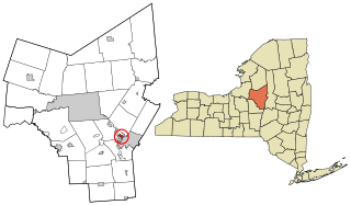
Oneida County is a county in the state of New York, United States. As of the 2020 census, the population was 232,125. The county seat is Utica. The name is in honor of the Oneida, one of the Five Nations of the Iroquois League or Haudenosaunee, which had long occupied this territory at the time of European encounter and colonization. The federally recognized Oneida Indian Nation has had a reservation in the region since the late 18th century, after the American Revolutionary War.

<span class="mw-page-title-main">Cold Brook, New York</span> Village in New York, United States

Cold Brook is a village in Herkimer County, New York. The population was 329 at the time of the 2010 census. It is named after a stream passing through the village. The village is located in the south part of the town of Russia and is northeast of Utica.

Lenox is a town in Madison County, New York, United States. The population was 9,112 as of the 2010 census.

Clark Mills is a hamlet in Oneida County, New York, United States. The population was 1,905 at the 2010 census.

<span class="mw-page-title-main">Marcy, New York</span> Town in New York, United States

Marcy is a town in Oneida County, New York, United States. The population was 8,982 at the 2010 census. The town was named after Governor William L. Marcy. It lies between the cities of Rome and Utica. The Erie Canal passes through the southern part of the town.

<span class="mw-page-title-main">New York Mills, New York</span> Village in New York, United States

New York Mills is a village in Oneida County, New York, United States. The population was 3,327 at the 2010 census.

<span class="mw-page-title-main">Oneida Castle, New York</span> Village in Oneida County, New York, US

Oneida Castle is a village in Oneida County, New York, United States. The population was 625 at the 2010 census.

<span class="mw-page-title-main">Paris, New York</span> Town in New York, United States

Paris is a town in Oneida County, New York, United States. The town is in the southeast part of the county and is south of Utica. The population was 4,411 at the 2010 census. The town was named after an early benefactor, Colonel Isaac Paris.

<span class="mw-page-title-main">Prospect, New York</span> Hamlet in New York, United States

Prospect is a hamlet in the town of Trenton, in Oneida County, New York, United States. The population was 291 at the 2010 census. The hamlet is located at the junction of NY 365 and Reference Route 920V west of West Canada Creek. It was an incorporated village from 1890 to 2015.

<span class="mw-page-title-main">Steuben, New York</span> Town in Oneida County, New York, US

Steuben is a town in Oneida County, New York, United States. The population was 1,110 at the 2010 census. The town is named after Baron von Steuben, a Prussian general who fought on the American side in the American Revolutionary War.

<span class="mw-page-title-main">Sylvan Beach, New York</span> Village in New York, United States

Sylvan Beach is a village in Oneida County, New York, United States; in the southeastern end of the Town of Vienna. It is twenty-two miles west of Rome. At the 2010 census, the population of Sylvan Beach was 897.

<span class="mw-page-title-main">Westmoreland, New York</span> Town in New York, United States

Westmoreland is a town in Oneida County, New York, United States. The population was 6,138 at the 2010 census.

<span class="mw-page-title-main">Whitesboro, New York</span> Village in New York, United States

Whitesboro is a village in Oneida County, New York, United States. The population was 3,772 at the 2010 census. The village is named after Hugh White, an early settler.

<span class="mw-page-title-main">Whitestown, New York</span> Town in New York, United States

Whitestown is a town in Oneida County, New York, United States. The population was 18,667 at the 2010 census. The name is derived from Judge Hugh White, an early settler. The town is immediately west of Utica and the New York State Thruway passes across the town. The offices of the town of Whitestown are in the Village of Whitesboro.

<span class="mw-page-title-main">Yorkville, Oneida County, New York</span> Village in New York, United States

Yorkville is a village in Oneida County, New York, United States. The population was 2,689 at the 2010 census.

<span class="mw-page-title-main">New Hartford, New York</span> Town in New York, United States

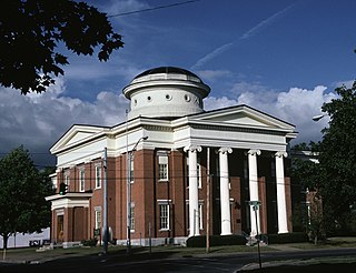
New Hartford is a town in Oneida County, New York, United States. As of the 2010 census, the town population was 22,166. The name of New Hartford was provided by a settler family from Hartford, Connecticut.

<span class="mw-page-title-main">Remsen (village), New York</span> Village in New York, United States

Remsen is a village in Oneida County, New York, United States. The population was 508 at the 2010 census.

<span class="mw-page-title-main">Vernon (village), New York</span> Village in New York, United States

Vernon is a village in Oneida County, New York, United States. The population was 1,172 at the 2010 census.

<span class="mw-page-title-main">Vernon, New York</span> Town in New York, United States

Vernon is a town in Oneida County, New York, United States. The population was 5,408 at the 2010 census.

<span class="mw-page-title-main">Utica–Rome metropolitan area</span> Metropolitan area in New York, United States

The Utica–Rome Metropolitan Statistical Area, as defined by the United States Census Bureau, is an area consisting of two counties in Central New York anchored by the cities of Utica and Rome. As of the 2020 census, the MSA had a population of 292,264.

References

  1. "ArcGIS REST Services Directory". United States Census Bureau. Retrieved September 20, 2022.
  2. http://www.nhfd.com nhfd.com
  3. OC911 2013 Dispatches
  4. "National Register Information System". National Register of Historic Places . National Park Service. March 13, 2009.
  5. "US Gazetteer files: 2010, 2000, and 1990". United States Census Bureau. February 12, 2011. Retrieved April 23, 2011.
  6. "Census of Population and Housing". Census.gov. Retrieved June 4, 2015.
  7. "U.S. Census website". United States Census Bureau . Retrieved January 31, 2008.