Old name for Spanish-occupied central Texas and Louisiana (1722–1821)
For the island chain in the Pacific Ocean historically named New Philippines, see Caroline Islands.
New Spain in 1794, with its province of New Philippines to its northeast, in light orange, west of Spanish Louisiana, in purple
New Philippines (Spanish: Nuevas Filipinas or Nuevas Philipinas) was the abbreviated name[a] of a territory in New Spain. Its full and official name was Nuevo Reino de Filipinas.[2][b]
Like other provinces, the territory was named after other existing dominions, in this case the Philippines, hence "New Philippines". The former were named after Philip II of Spain and the latter were named after the then-sovereign, King Philip V of Spain.[4] New Philippines ceased to be a legal entity upon the extinction of New Spain in 1821.
Limits
New Philippines Province overlapped in part with the current U.S. state of Texas, but its territory was substantially different. The land consisted of the region north of the Medina and Nueces rivers, in what is now South-Central Texas; i.e., only the Central-Northern part of the current state overlaps with the territory of New Philippines.
The Medina River was the official border between New Extremadura and New Philippines.[5] West of the Medina headwaters, the southern border was with Nueva Vizcaya. The border with Nuevo Santander was the Nueces River.[6]
To the west, New Philippines bordered Nueva Vizcaya and Nuevo México; to the north, the border almost reached the Red River; to the east, the border was consecutively French, Spanish, and finally American.
Disputed eastern border
France claimed its border extended west and south to the Rio Grande (thus entirely negating the existence of New Philippines); conversely, Spain claimed its east border extended to the Red River.[7] The French founded Natchitoches in 1714 east of the Red River (later moving their post from the east to the west side of the river about 1734), and the Spanish founded Los Adaes in 1721 near present-day Robeline, Louisiana, only 12miles (19km) from Natchitoches. Informally, the border was set at the Arroyo Hondo, located between the French and the Spanish settlements, for the next 98 years.[8][9][10] Following the 1819 Treaty of Adams-Onís, the New Spain and Louisiana border moved 45miles (72km) west to the Sabine River and remained there until the extinction of New Spain in 1821.
History
In the 16th century, the northern frontier of New Spain was Nueva Vizcaya, beginning from 1531. As development increased in the 17th century, a new province was created on its east in 1687, namely, Nueva Extremadura, a very extensive territory at the time, now identified with the much smaller state of Coahuila, in Mexico.[11]
In 1722, the northeast of Nueva Extremadura was politically detached and officially named Nuevo Reino de las Filipinas, also known by its short form, Nuevas Filipinas.[2] The second Marqués de Aguayo was named governor of New Philippines.[12][13]
Origins of the name
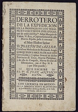
Cover page of the 1720-1722 expedition into the "Nuevo Reyno de Philipinas," a chronicle by Juan Antonio de la Peña
The name was first used by Antonio Margil in July 1716, during his participation in Domingo Ramón's expedition to prevent French expansion from Louisiana.[c] Some sources say it was Ramón himself who used it first, followed by Margil on his July letter.[d] The next record of the name is a letter written by Isidro de Espinosa in February 1718.[15]
The name first appeared in an official document in 1718, in a letter addressed to Martín de Alarcón:[16] A March 11, 1718 instruction letter for Alarcon's 1718 reinforcements expedition refers to "Nuevas Filipinas",[e] differentiating New Philippines from the province of Coahuila and New Extremadura.[17] In a report of his services to the Spanish government, Alarcón would go on to refer to himself as "governor and lieutenant captain general of the Province of the Texas and New Philippines."[18] Alarcón signed the foundation document of the San Antonio de Valero mission, dating it May 1, 1718, in his capacity as "General of the Provinces of the Kingdom of New Philippines."[19] Much later, the mission would be garrisoned and become the site of the 1836 Battle of the Alamo.
Use of the name in monographs and chronicles
Juan Antonio de la Peña, a participant in the Marqués de Aguayo expedition, wrote Derrotero de la expedición en la provincia de los Texas, Nuevo Reyno de Philipinas, and had it printed in México in 1722.[20][21]
Pedro de Rivera y Villalón, a brigadier general, described the Reino de Nuevas Philipinas,[3]:7 which he inventoried during his 1724-1728 mission to northern New Spain,[3]:4 in his 1736 book Diario y derrotero de lo caminado.[22]
The Irish-Spaniard monk Juan Agustín Morfi wrote in 1779 the Relación geográfica e histórica de la provincia de Texas o Nuevas Filipinas. His book was translated to English and published in 1935 by Carlos Castañeda as "History of Texas: 1673–1779. By fray Juan Agustin Morfi. Missionary, Teacher, Historian".[23] Morfi is considered the most important chronicler and historian of New Philippines.[f]
Royal correspondence
Philip V having assented to his governorship of the territory, the Marqués de Aguayo on June 13, 1722, wrote back, thanking the king that the recovery (from the French) of the "New Kingdom of the Philippines, should have been entrusted to my feeble management."[13]
Disestablishment
After Philip V's death in 1746, there were no other Spanish kings named Philip until 2014. The name New Philippines progressively ceased to be used in government reports, the census, instructions, and correspondence, and by the early 1800s few legal documents made reference to New Philippines, other than in land grants.[g][14]
With the end of New Spain and the creation of the Mexican Empire in 1821, the sole legal name for the territory of New Philippines became Provincia de Texas, which years later became part of the Mexican state of Coahuila y Tejas.
Notes
↑"Nueva Filipinas, probably the abbreviated form"[1]
↑varias descripciones: [...] del Nuevo Reino de Filipinas[3]:7
↑"Antonio Margil de Jesús evidently first used the name Nuevas Filipinas in a letter to the viceroy dated July 20, 1716"[14]
↑"According to erudite sources, Domingo Ramón, a missionary-explorer first used it"[1]
↑«for the first time in an official document, refer to Texas as "Nuevas Filipinas"»[14]
↑"se trata del principal historiador y cronista de la provincia de Nuevas Filipinas"[24]
↑"by 1800, it began to fall into disuse except for documents pertaining to land grants. Government reports, the census, instructions, and correspondence no longer made reference to Nuevas Filipinas"[1]
12(Arreola 2002, p.27): "politically an extension of Coahuila until 1722. Officially, the province was known as Nuevo Reino de las Filipinas, or Nuevas Filipinas"
↑Isaac Smith Homans; Isaac Smith Homans, Jr. (1858). A Cyclopedia of Commerce and Commercial Navigation. New York: Harper & Brothers, Publishers. p.1834. Retrieved 31 August 2021. But this province extended then only as far south as the river Medina. The southwestern part of our present Texas belonged still for a long while to "the Province of Coahuila" [...] this establishment of Texas as a new and separate government by itself (in 1727) was also connected to the introduction of a new name —of Las Nuevas Filipinas
↑Clare D’Artois Leeper (2012). "Arroyo Hondo". Louisiana Place Names (Illustrateded.). Louisiana State University Press. p.20. ISBN978-0807147405. Retrieved 2 September 2021. became famous after it was accepted as the temporary border between French Louisiana and the Spanish province of Texas
123Jesús "Frank" de la Teja (1976). "New Philippines". Handbook of Texas. Texas State Historical Association. Archived from the original on 11 November 2020. Retrieved 31 August 2021.
↑"El Nuevo Reino de Filipinas". Yahoo News. Manila Bulletin. 24 September 2014. Retrieved 25 January 2022. in December, 1717. However, the following year, Nuevas Filipinas appeared in the heading of a letter written by Fr. Isidro Felix de Espinosa in February
This page is based on this Wikipedia article Text is available under the CC BY-SA 4.0 license; additional terms may apply. Images, videos and audio are available under their respective licenses.