
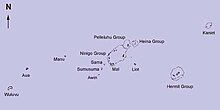

The Ninigo Islands are a group of 31 [1] islands within the Western Islands of the Bismarck Archipelago, Papua New Guinea. Their coordinates are 1°16′S144°15′E / 1.267°S 144.250°E . [1]
The Ninigo Islands are a group of 31 [1] islands within the Western Islands of the Bismarck Archipelago, Papua New Guinea. Their coordinates are 1°16′S144°15′E / 1.267°S 144.250°E . [1]
The first settlers on the Ninigo Islands were the Melanesians. Other groups later settled in the island group, including the Polynesians and Germans. These islands belong to Micronesian outliers.
The first sighting by Europeans of Ninigo islands was by the Spanish navigator Iñigo Órtiz de Retes on 27 July 1545 when on board of the carrack San Juan tried to return from Tidore to New Spain. He charted them as La Barbada (the bearded island in Spanish). [2] [3]
During World War II, the Imperial Japanese Army occupied large portions of the Pacific islands, including the Bismarck Archipelago, after their initial advances in the early years of the war. The Ninigo Islands were used by the Japanese military primarily for their strategic position and as a base for supply and communications.[ citation needed ]
The Ninigo Islands became part of the broader Allied campaign to retake control of the Pacific from Japanese forces in 1944. U.S. and Australian forces launched numerous air and naval strikes to weaken Japanese positions. However, limited direct combat actions were specifically tied to the islands, unlike other prominent locations, such as mainland New Guinea or the Solomon Islands.[ citation needed ]
The magnitude of the Ninigo Islands is more often mentioned in terms of their location as a stepping stone in the Allies' island-hopping strategy, designed to isolate and neutralize Japanese strongholds in the Pacific. After a series of intense campaigns, including the recapture of New Guinea and the Solomon Islands, Japanese resistance in the island group was significantly reduced in late 1944.[ citation needed ]
The Admiralty Islands are an archipelago group of 40 islands in the Bismarck Archipelago, to the north of New Guinea in the South Pacific Ocean. These are also sometimes called the Manus Islands, after the largest island.
During World War II, the United States Army divided its operations around the world into four theaters. Forces from many different Allied nations fought in these theaters. Other Allied countries have different conceptions of the theaters and/or different names for them.

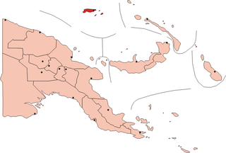
The Bismarck Archipelago is a group of islands off the northeastern coast of New Guinea in the western Pacific Ocean and is part of the Islands Region of Papua New Guinea. Its area is about 50,000 square kilometres (19,000 sq mi).

The Mariana Islands, also simply the Marianas, are a crescent-shaped archipelago comprising the summits of fifteen longitudinally oriented, mostly dormant volcanic mountains in the northwestern Pacific Ocean, between the 12th and 21st parallels north and along the 145th meridian east. They lie south-southeast of Japan, west-southwest of Hawaii, north of New Guinea, and east of the Philippines, demarcating the Philippine Sea's eastern limit. They are found in the northern part of the western Oceanic sub-region of Micronesia, and are politically divided into two jurisdictions of the United States: the Commonwealth of the Northern Mariana Islands and, at the southern end of the chain, the territory of Guam. The islands were named after the influential Spanish queen Mariana of Austria following their colonization in the 17th century.

German New Guinea consisted of the northeastern part of the island of New Guinea and several nearby island groups and was the first part of the German colonial empire. The mainland part of the territory, called Kaiser-Wilhelmsland, became a German protectorate in 1884. Other island groups were added subsequently. The Bismarck Archipelago, and the North Solomon Islands were declared a German protectorate in 1885. The Caroline Islands, Palau, and the Mariana Islands were bought from Spain in 1899. German New Guinea annexed the formerly separate German Protectorate of Marshall Islands, which also included Nauru, in 1906. German Samoa, though part of the German colonial empire, was not part of German New Guinea.

The Asiatic–Pacific Campaign Medal was a United States military award of the Second World War, which was awarded to any member of the United States Armed Forces who served in the Asiatic-Pacific Theater from 1941 to 1945. The medal was created on November 6, 1942, by Executive Order 9265 issued by President Franklin D. Roosevelt. The medal was designed by Thomas Hudson Jones; the reverse side was designed by Adolph Alexander Weinman which is the same design as used on the reverse of the American Campaign Medal and European-African-Middle Eastern Campaign Medal.

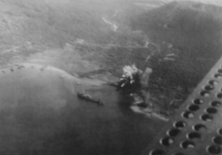
The Battle of the Bismarck Sea took place in the South West Pacific Area (SWPA) during World War II when aircraft of the U.S. Fifth Air Force and the Royal Australian Air Force (RAAF) attacked a Japanese convoy carrying troops to Lae, New Guinea. Most of the Japanese task force was destroyed, and Japanese troop losses were heavy.

The Solomon Islands campaign was a major campaign of the Pacific War of World War II. The campaign began with Japanese landings and capture of several areas in the British Solomon Islands and Bougainville, in the Territory of New Guinea, during the first six months of 1942. The Japanese occupied these locations and began the construction of several naval and air bases with the goals of protecting the flank of the Japanese offensive in New Guinea, establishing a security barrier for the major Japanese base at Rabaul on New Britain, and providing bases for interdicting supply lines between the Allied powers of the United States and Australia and New Zealand.

The New Guinea campaign of the Pacific War lasted from January 1942 until the end of the war in August 1945. During the initial phase in early 1942, the Empire of Japan invaded the Territory of New Guinea on 23 January and Territory of Papua on 21 July and overran western New Guinea beginning on 29 March. During the second phase, lasting from late 1942 until the Japanese surrender, the Allies—consisting primarily of Australian forces—cleared the Japanese first from Papua, then New Guinea, and finally from the Dutch colony.
The New Britain campaign was a World War II campaign fought between Allied and Imperial Japanese forces. The campaign was initiated by the Allies in late 1943 as part of a major offensive which aimed to neutralise the important Japanese base at Rabaul, the capital of New Britain, and was conducted in two phases between December 1943 and the end of the war in August 1945.
The Battle of Vella Lavella was fought from 15 August – 6 October 1943 between the Empire of Japan and the Allied forces from New Zealand and the United States at the end of the New Georgia campaign. Vella Lavella, an island located in the Solomon Islands, had been occupied by Japanese forces early during the war in the Pacific. Following the Battle of Munda Point, the Allies recaptured the island in late 1943, following a decision to bypass a large concentration of Japanese troops on the island of Kolombangara.

The South West Pacific theatre, during World War II, was a major theatre of the war between the Allies and the Axis. It included the Philippines, the Dutch East Indies, Borneo, Australia and its mandate Territory of New Guinea and the western part of the Solomon Islands. This area was defined by the Allied powers' South West Pacific Area (SWPA) command.

The Western Islands are a group of islands in the Bismarck Archipelago, and within Manus Province of the Islands Region, in northern Papua New Guinea.

The 345th Bombardment Group is an inactive United States Air Force unit. Its last assignment was with the Tactical Air Command at Langley Air Force Base, Virginia, where it was inactivated on 25 June 1959.

Operation Dexterity was a military operation, part of Operation Cartwheel in the South West Pacific Area (SWPA) for the Allies in the Pacific theater of World War II. The operation was directed by the Supreme Allied Commander in the SWPA, General Douglas MacArthur. Dexterity included amphibious landings at Arawe on 15 December 1943, and Cape Gloucester on 26 December 1943 in the northwest of New Britain, the capture of the Imperial Japanese held Tuluvu aerodrome on the 30 December 1943 and the amphibious landing at Saidor on 2 January 1944. The final battle was the landing at Talasea in March. The operation ended on 9 March 1944.

During World War II, the United States Army Air Forces engaged in combat against the air, ground and naval forces of the Empire of Japan in the South West Pacific Theatre.
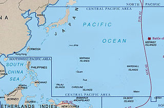
During World War II, the United States Army Air Forces fought the Empire of Japan in the Central Pacific Area. As defined by the War Department, this consisted of most of the Pacific Ocean and its islands, excluding the Philippines, Australia, the Netherlands East Indies, the Territory of New Guinea the Solomon Islands and areas to the south and east of the Solomons.

The Solomon Islands (archipelago) is an island group in the western South Pacific Ocean, north-east of Australia. The archipelago is in the Melanesian subregion and bioregion of Oceania and forms the eastern boundary of the Solomon Sea. The many islands of the archipelago are distributed across the sovereign states of Papua New Guinea and Solomon Islands. The largest island in the archipelago is Bougainville Island, which is a part of the Autonomous Region of Bougainville along with Buka Island, the Nukumanu Islands, and a number of smaller nearby islands. Much of the remainder falls within the territory of Solomon Islands and include the atolls of Ontong Java, Sikaiana, the raised coral atolls of Bellona and Rennell, and the volcanic islands of Choiseul, Guadalcanal, Makira, Malaita, New Georgia, the Nggelas, Santa Isabel, and the Shortlands. The Santa Cruz Islands are not a part of the archipelago.
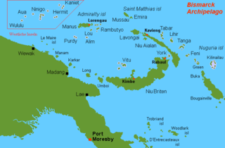
The Hermit Islands are a group of 17 islands within the Western Islands of the Bismarck Archipelago, Papua New Guinea. Their coordinates are 1°30′S145°4′E.
The neutralisation of Rabaul was an Allied campaign to render useless the Imperial Japanese base at Rabaul in eastern New Britain, Papua New Guinea. Japanese forces landed on Rabaul on 23 January 1942, capturing it by February 1942, after which the harbor and town were transformed into a major Japanese naval and air installation. The Japanese heavily relied on it, using it as a launching point for Japanese reinforcements to New Guinea and Guadalcanal. Throughout the Solomon Islands campaign, neutralizing Rabaul became the primary objective of the Allied effort in the Solomons.
Islands of Papua New Guinea | |
|---|---|
| Bismarck Archipelago | |
| Louisiade Archipelago | |
| North Solomon Islands | |
| | This Manus Province geography article is a stub. You can help Wikipedia by expanding it. |