Woodlark Island

Last updated
Woodlark
Native name:
Muyua, Muyuw
Karta PG Woodlark isl.png
Woodlark Islands
Papua New Guinea location map.svg
Red pog.svg
Woodlark
Woodlark Island (Papua New Guinea)
Geography
Location Melanesia
Coordinates 9°7′35″S152°48′20″E / 9.12639°S 152.80556°E / -9.12639; 152.80556
Highest elevation240 m (790 ft)
Highest pointMount Kabat
Administration
Province Milne Bay Province
Largest settlement Kulumadau (pop. 242 in 1990 (est. 2,500 in 2010 by unofficial census))
Demographics
Population~1,700 (est. 6,000 in 2010 by unofficial census) (1990)

Woodlark Island, known to its inhabitants simply as Woodlark or Muyua, is the main island of the Woodlark Islands archipelago, located in Milne Bay Province and the Solomon Sea, Papua New Guinea.

Contents

Although no formal census has been conducted since 1990, the current population is estimated at approximately 6000 people (see section below on Population Issues). There is one primary school on the island (in Kulumadau) that teaches about 200 students (60 students are from outer islands); to attend highschool/secondary school, all children must travel to Alotau on the mainland. [1]

Etymology

AS07-04-1609 (21 Oct. 1968) --- Woodlark Island in the Solomon Sea, east of New Guinea and northeast of Australia, as seen from the Apollo 7 spacecraft during its 158th revolution of Earth. Photographed from an altitude of 140 nautical miles, at ground elapsed time of 251 hours and 21 minutes. AS07-04-1609.jpg
AS07-04-1609 (21 Oct. 1968) --- Woodlark Island in the Solomon Sea, east of New Guinea and northeast of Australia, as seen from the Apollo 7 spacecraft during its 158th revolution of Earth. Photographed from an altitude of 140 nautical miles, at ground elapsed time of 251 hours and 21 minutes.

Woodlark Island is also called Woodlark or Woodlarks [2] by English language speakers. It is called Murua by the inhabitants of some other islands in the province. [2] The wider Woodlark Islands group also consists of Madau and Nusam to the west, Nubara to the east, and the Marshall Bennett group to the southwest.

History

The Australian whaling ship Woodlark (Captain George Grimes) called in the 1830s and the report of that visit led to Woodlark's name being attached to the island. [3] Other whaling ships visited for water and wood in the decades that followed and islanders sometimes served as crewmen on those vessels. The last recorded whaling ship to call was the American vessel Adeline Gibbs in October 1873. [4]

An Italian missionary order of Catholic clergy, the Pontifical Institute for Foreign Missions (P.I.M.E.), sent five priests and two brothers to Woodlark Island in 1852. Giovanni Battista (John) Mazzucconi was killed there in 1855 by an islander called Avicoar who opposed the missionaries and their religion. [5]

Richard Ede and Charles Lobb, who had a trading post on the nearby Laughlan (Nada) Islands, discovered gold on the island in 1895. [6] News of the find sparked off a gold-rush from Australia. By early 1897, steamers were arriving with gold seekers from Queensland every fortnight. In 1896–97, there were 400 white miners and 1,600 Papuan labourers on Woodlark who produced 20,000 ounces of gold. [7] Records show an estimated pre-World War II gold production, including alluvial sources, of about 220,000 ounces of gold.

Operation Chronicle was the name given to the landing of the United states's 112th Cavalry Regiment on Woodlark Island and Kiriwina on June 30, 1943, during World War II. Within a few months of the landing Seabees of the 60th Naval Construction Battalion had constructed a major airbase at Guasopa Bay, known as Woodlark Airfield (later Guasopa Airport).

The island has been extensively logged for ebony which has always been an important cash commodity to the communities on the island since the 1970s. Modern gold exploration was initiated on Woodlark Island in 1962 with the Bureau of Mineral Resources undertaking surface geochemistry, limited geophysics, and diamond drilling during 1962 and 1963 at Kulumadau. [8]

Population issue

The most recent figures are those of the 1990 census, which note about 1,700 people. The largest villages in the census were Kaulay (160), Moniveyova (140) and Wabunun (154), and these villages are the largest today. However, separate from the villages are the two post-colonial creations of Guasopa and Kulumadau (described in the census book as 'large rural non-villages'), which both have relatively large populations, 147 and 242 respectively. As such, Kulumadau is typically seen as the largest conglomeration of people on the island. Since the 1990 census, Guasopa has gained a health center, while Kulumadau has gained a medium-sized timber company (Milne Bay Logging) and a mining exploration camp (BHP).

In terms of the traditional divisions of the island, the eastern region (Muyuw) accounts for about 600 people (44% total population), central region (Wamwan) for 400 people (30% total population), and the southern region (Madau/Neyam) for 350 people (26% total population). An unofficial census in 2010 counts place the total population of Woodlark Island at around 6,000 people, with the largest conglomeration of people still in the non-villages of Kulumadau and Guasopa, and the largest village of Kaulay. [9]

Historically, the island may have lost up to two-thirds of its population between 1850 and 1920, according to Fred Damon, an anthropology professor from the University of Virginia who lived on Woodlark Island in the mid-1970s. That is, from an estimated 2,200 people on Woodlark Island during first European contact, the population had dropped to between 700 and 900 by about 1915, though it has rebounded over the years. [9]

Geography

Geology

The island includes a volcanic core of Tertiary age and a wide limestone belt, mainly originated by corals (coral reefs are still active around the island). Also intrusive rocks and sedimentary sands are found. [10] [11]

Fauna

Murua Gharial

An extinct gharial species, "Gavialis" papuensis (occasionally informally referred to as "Murua Gharial"), occurred in Woodlark Island during the Pleistocene or Holocene period. [12] A late surviving gryposuchine, this 2-3 meter long piscivore was the last known truly marine crocodilian (modern saltwater crocodiles that still occur in the Solomon only occasionally venture into the sea, preferring freshwater environments), found in association with sirenian and sea turtle remains. Like other insular Pleistocene megafauna, it was presumably hunted to extinction by the first human settlers of the islands.

Conservation

A plan by the Malaysian company Vitroplant to use 70% of the island for palm oil production was scrapped after opposition from the islands inhabitants. [13] [14] [15] The project was seen as a threat to endemic organisms on the island. [15] As of 2009, a full wildlife survey of the island had not yet been carried out. [13]

Endemic snakes

Due to its relative isolation, Woodlark Island is home to two endemic snake taxa.

There are no medically important terrestrial venomous snakes on Woodlark Island.

Demographics

Muyuw language, one of the Kilivila–Louisiades languages and part of the Austronesian language family, is spoken on the island.

Related Research Articles

<span class="mw-page-title-main">Boidae</span> Family of snakes

The Boidae, commonly known as boas or boids, are a family of nonvenomous snakes primarily found in the Americas, as well as Africa, Europe, Asia, and some Pacific islands. Boas include some of the world's largest snakes, with the green anaconda of South America being the heaviest and second-longest snake known; in general, adults are medium to large in size, with females usually larger than the males. Six subfamilies comprising 15 genera and 54 species are currently recognized.

<span class="mw-page-title-main">Bougainville Island</span> Island in Papua New Guinea

Bougainville Island is the main island of the Autonomous Region of Bougainville, which is part of Papua New Guinea. It was previously the main landmass in the German Empire-associated North Solomons. Its land area is 9,300 km2 (3,600 sq mi). The population of the whole province, including nearby islets such as the Carterets, is approximately 300,000. The highest point is Mount Balbi, on the main island, at 2,715 m (8,907 ft). The much smaller Buka Island, c. 500 km2 (190 sq mi), lies to the north, across the 400–500 m (1,300–1,600 ft) wide Buka Strait. Even though the strait is narrow, there is no bridge across it, but there is a regular ferry service between the key settlements on either side. The main airport in the north is in the town of Buka.

<span class="mw-page-title-main">Milne Bay Province</span> Place in Papua New Guinea

Milne Bay is a province of Papua New Guinea. Its capital is Alotau. The province covers 14,345 km² of land and 252,990 km² of sea, within the province there are more than 600 islands, about 160 of which are inhabited. The province has about 276,000 inhabitants, speaking about 48 languages, most of which belong to the Eastern Malayo-Polynesian branch of the Austronesian language family. Economically the province is dependent upon tourism, oil palm, and gold mining on Misima Island; in addition to these larger industries there are many small-scale village projects in cocoa and copra cultivation. The World War II Battle of Milne Bay took place in the province.

<span class="mw-page-title-main">Madau</span>

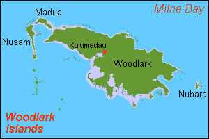
Madau is an island of the Woodlark Islands group, in the Solomon Sea and Milne Bay Province of Papua New Guinea.

<span class="mw-page-title-main">Misima Island</span>

Misima is a volcanic island in the northwest of Louisiade Archipelago within Milne Bay Province of Papua New Guinea.

Albert Stewart Meek was an English bird collector and naturalist.

<i>Candoia</i> Genus of snakes

Candoia is a genus of non-venomous boas found mostly in New Guinea, Melanesia and the Maluku Islands in Indonesia. Common names include bevel-nosed boas and keel-scaled boas.

<span class="mw-page-title-main">Nukumanu Islands</span> Atoll in Papua New Guinea

The 2007 Solomon Islands earthquake took place on 2 April 2007, near the provincial capital of Gizo on Ghizo Island, in the Solomon Islands. Its magnitude was estimated at 8.1 on the Mw scale, and 7.8 on the Ms scale. The tsunami that followed the earthquake killed 52 people. According to the USGS, the earthquake was recorded around 7:39:56 a.m. local time (UTC+11). The focus was 10 km (6 mi) deep and 40 km (25 mi) south southeast of Gizo township on New Georgia Islands in Western Province. There were numerous aftershocks, the largest of which had a magnitude of 6.2.

<span class="mw-page-title-main">Districts of Papua New Guinea</span> Second-level administrative division

This page is a list of districts of Papua New Guinea.

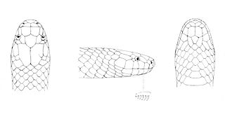
Ikanogavialis is an extinct genus of gavialid crocodilian. Fossils have been found in the Urumaco Formation in Urumaco, Venezuela and the Solimões Formation of Brazil. The strata from which remains are found are late Miocene in age, rather than Pliocene as was once thought. A possible member of this genus survived into the Late Holocene on Muyua or Woodlark Island in Papua New Guinea.

<span class="mw-page-title-main">Iwa Island</span>

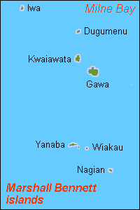
Iwa Island is an island located in the Solomon Sea, approximately 130 miles (200 km) from mainland New Guinea and 310 miles (500 km) from Port Moresby. It is part of the Marshall Bennett Islands group and considered part of Papua New Guinea.

Guasopa is a village on Woodlark Island, Milne Bay Province Papua New Guinea. It is served by Guasopa Airport. Its population during the 1990 census was 170, though it has since grown extensively. Guasopa is the location of the Guasopa Health Center; this health center serves as the regional health care center, and has a team of nine health workers who service the population of around 6,000 people on Woodlark Island. This team also provide support for the other aid posts on the island and carry out patrols to surrounding islands. There is one school in Guasopa, though most students in the area go to Kulumadau Primary School. Students must travel to Alotau on the mainland to attend secondary school.

Samarai-Murua District is a district of the Milne Bay Province of Papua New Guinea. Its capital is Murua. The population of the district was 58,590 at the 2011 census.

<i>Toxicocalamus</i> Genus of snakes

Toxicocalamus is a genus of snakes in the family Elapidae. The genus is endemic to New Guinea.

<span class="mw-page-title-main">Woodlark Basin</span> Oceanic basin located to the east of the island of New Guinea

The Woodlark Basin is a young geologic structural basin located in the southwestern Pacific Ocean, found to the southeast of the island country of Papua New Guinea. The basin is an extensional basin that is actively spreading and has a seafloor spreading center. This basin lies between the Indo-Australian Plate and the Solomon microplate and is located between the Louisiade Archipelago, Woodlark Island to the north and the northern Solomon Islands. The Woodlark Basin has an interesting and complex geologic history dating back twenty million years to the initial opening of the basin; the spreading of the basin, however, has occurred within the past 3.6 million years.

Kulumadau is a large, rural non-village on Woodlark Island, Milne Bay Province Papua New Guinea. It is served by Guasopa Airport. Its population during the 1990 census was 242, though it has since grown extensively; its current population is reported to be about 2,500 people, but there are no official sources for this number, as the last official census was taken in 1990. There is a large primary school in Kulumadau, where 200 students are taught. Students must travel to Alotau on the mainland to attend secondary school. Kulumadau was built in the post-colonial times, and as such, is not considered a traditional village of Woodlark, however, since its inception, Kulumadau has been the primary population center on Woodlark Island.

Murua Rural LLG is a local-level government (LLG) of Milne Bay Province, Papua New Guinea.

Candoia paulsoni, also known as the Solomon Islands ground boa, is a species of boa native to the Maluku Islands and Melanesia. Five subspecies are recognized.

Samuel Booker McDowell Jr was an American herpetologist who worked on the comparative anatomy of turtles and snakes and studied snakes of Oceania.

References

  1. Kent Harland (2011). "A Brief Overview of Woodlark Island" . Retrieved 2015-08-24.
  2. 1 2 Seligman, C.G. (1910). The Melanesians of British New Guinea. Cambridge: Cambridge University Press. p.  40.
  3. "Sydney's whaling fleet", dictionaryofsydney.org
  4. Robert Langdon (ed) (1884), Where the whalers went: An index to the Pacific ports and islands visited by American whalers (and some other ships) in the 19th century, Canberra, Pacific Manuscripts Bureau, p.189. ISBN   086784471X
  5. Thomas Mary Sennott (14 January 2009). "Blessed John Mazzucconi and the New Guinea Battlefield". catholicism.org.
  6. Nelson, Hank (1976) Black, white & gold: goldmining in Papua New Guinea, 1878-1930, Canberra, Australian National University Press, p.54. ISBN   0708104878
  7. Nelson, p.57
  8. KulaGolda (2014). "Woodlock Island Gold Project". Archived from the original on 2017-09-27. Retrieved 2015-08-24.
  9. 1 2 Michael Young (1990). "Fieldwork on Woodlark (Muyuw) Island" . Retrieved 2015-08-24.
  10. D.S.Trails (1961). "The geology of Woodlark Island" (PDF). Retrieved 2014-09-07.
  11. D.S.Trails (1967). "Geology of Woodlark Island, Papua" (PDF). Retrieved 2014-09-07.
  12. Molnar, R. E. 1982. A longirostrine crocodilian from Murua (Woodlark), Solomon Sea. Memoirs of the Queensland Museum 20, 675-685.
  13. 1 2 Gascoigne, Ingrid. Papua New Guinea (Cultures of the World). 2009-03. Benchmark Books. p. 54. ISBN   978-0-7614-3416-0.
  14. "70% of rainforest island to be cleared for palm oil". Mongabay.com. 2007-12-13. Retrieved 16 September 2010.
  15. 1 2 "Planned logging of Woodlark Island for biofuels opposed by islanders and scientists". Mongabay.com. 2007-11-12. Retrieved 16 September 2010.
  16. Smith, H.M., D. Chiszar, K. Tepedelen & F. van Breukelen 2001 A revision of the bevelnosed boas (Candoia carinata complex) (Reptilia: Serpentes). Hamadryad. 26 (2):283-315.
  17. McDowell, S.B. 1979 A catalogue of the snakes of New Guinea and the Solomons, with special reference to those in the Bernice P. Bishop Museum. Journal of Herpetology. 13(1):1-92.
  18. Boulenger, G.A. 1896 Description of a new genus of elapine snakes from Woodlark Island, British New Guinea. Annals and Magazine of Natural History. 6 (18) (104):152.

09°07′15″S152°44′10″E / 9.12083°S 152.73611°E / -9.12083; 152.73611