North Powder, Oregon

Last updated

North Powder, Oregon
A.B. Hudelson N. Powder.jpg
Building in downtown North Powder
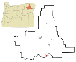
Union County Oregon Incorporated and Unincorporated areas North Powder Highlighted.svg
Location in Oregon
Coordinates: 45°01′48″N117°55′13″W / 45.03000°N 117.92028°W / 45.03000; -117.92028
Country United States
State Oregon
County Union
Incorporated 1903
Government
   Mayor Bonita Hebert[ citation needed ]
Area
[1]
  Total0.63 sq mi (1.63 km2)
  Land0.63 sq mi (1.63 km2)
  Water0.00 sq mi (0.00 km2)
Elevation
[2]
3,265 ft (995 m)
Population
 (2020) [3]
  Total504
  Density802.55/sq mi (310.07/km2)
Time zone UTC-8 (Pacific)
  Summer (DST) UTC-7 (Pacific)
ZIP code
97867
Area code 541
FIPS code 41-53300 [4]
GNIS feature ID2411277 [2]

North Powder is a city in Union County, Oregon, United States. The population was 439 at the 2010 census.

Contents

History

North Powder was platted in 1885 or 1886 along the Oregon Railroad and Navigation Company rail line, having been a stage stop before then. [5]

David Eccles, a Mormon businessman, created the Hall Brothers Lumber Company in the town once the railway arrived. [6]

North Powder prospered because it had an icehouse that supplied the refrigerator cars of Pacific Fruit Express until the icehouse burned down in the 1930s. [5]

Geography

According to the United States Census Bureau, the city has a total area of 0.64 square miles (1.66 km2), all of it land. [7]

Climate

This region experiences warm (but not hot) and dry summers, with no average monthly temperatures above 71.6 °F (22.0 °C). According to the Köppen Climate Classification system, North Powder has a warm-summer Mediterranean climate, abbreviated "Csb" on climate maps. [8]

Demographics

Historical population
CensusPop.Note
1890 185
1910 455
1920 61334.7%
1930 553−9.8%
1940 376−32.0%
1950 4037.2%
1960 399−1.0%
1970 304−23.8%
1980 43041.4%
1990 4484.2%
2000 4899.2%
2010 439−10.2%
2020 50414.8%
U.S. Decennial Census [9] [3]

2010 census

As of the census of 2010, there were 439 people, 184 households, and 111 families living in the city. The population density was 685.9 inhabitants per square mile (264.8/km2). There were 214 housing units at an average density of 334.4 per square mile (129.1/km2). The racial makeup of the city was 92.5% White, 0.5% African American, 1.6% Native American, 0.5% Asian, 2.3% from other races, and 2.7% from two or more races. Hispanic or Latino of any race were 8.9% of the population. [4]

There were 184 households, of which 27.2% had children under the age of 18 living with them, 50.5% were married couples living together, 7.6% had a female householder with no husband present, 2.2% had a male householder with no wife present, and 39.7% were non-families. 31.5% of all households were made up of individuals, and 10.9% had someone living alone who was 65 years of age or older. The average household size was 2.39 and the average family size was 3.10. [4]

The median age in the city was 43.1 years. 26.4% of residents were under the age of 18; 3.7% were between the ages of 18 and 24; 21.2% were from 25 to 44; 31.4% were from 45 to 64; and 17.3% were 65 years of age or older. The gender makeup of the city was 48.1% male and 51.9% female. [4]

2000 census

As of the census of 2000, there were 489 people, 184 households, and 130 families living in the city. The population density was 797.7 inhabitants per square mile (308.0/km2). There were 209 housing units at an average density of 340.9 per square mile (131.6/km2). The racial makeup of the city was 96.32% White, 0.61% African American, 0.61% Native American, 0.41% Asian, 0.20% Pacific Islander, and 1.84% from two or more races. Hispanic or Latino of any race were 3.07% of the population. [4]

There were 184 households, out of which 32.1% had children under the age of 18 living with them, 56.5% were married couples living together, 9.2% had a female householder with no husband present, and 29.3% were non-families. 25.0% of all households were made up of individuals, and 10.9% had someone living alone who was 65 years of age or older. The average household size was 2.66 and the average family size was 3.11. [4]

In the city, the population was spread out, with 30.3% under the age of 18, 5.1% from 18 to 24, 26.0% from 25 to 44, 22.3% from 45 to 64, and 16.4% who were 65 years of age or older. The median age was 39 years. For every 100 females, there were 97.2 males. For every 100 females age 18 and over, there were 93.8 males. [4]

The median income for a household in the city was $24,167, and the median income for a family was $27,188. Males had a median income of $27,500 versus $19,063 for females. The per capita income for the city was $11,231. About 22.1% of families and 25.9% of the population were below the poverty line, including 39.6% of those under age 18 and 12.1% of those age 65 or over. [4]

Recreation

Anthony Lakes ski area is west of North Powder, in the Elkhorn Mountains and Wallowa–Whitman National Forest.

Notable people

Related Research Articles

<span class="mw-page-title-main">Tingley, Iowa</span> City in Iowa, United States

Tingley is a city in northern Ringgold County, Iowa, United States. The population was 136 at the time of the 2020 census.

<span class="mw-page-title-main">Oregon, Missouri</span> City in Missouri, United States

Oregon is a city and county seat of Holt County, Missouri, United States. The population was 837 at the 2020 census.

<span class="mw-page-title-main">Martin, North Dakota</span> City in North Dakota, United States

Martin is a city in Sheridan County, North Dakota, United States. The population was 63 at the 2020 census.

<span class="mw-page-title-main">Happy Valley, Oregon</span> City in Oregon, United States

Happy Valley is a suburban city in the Portland, Oregon metropolitan area. Happy Valley is near the northwest edge of Clackamas County, Oregon, United States approximately 10 miles to the southeast of downtown Portland, Oregon. The population was 23,733 at the 2020 census.

<span class="mw-page-title-main">Canyonville, Oregon</span> City in Oregon, United States

Canyonville is a city in Douglas County, Oregon, United States. The population was 1,884 at the 2010 census. The main regional tourist attraction, the Seven Feathers Casino Resort is in Canyonville.

<span class="mw-page-title-main">Glendale, Oregon</span> City in Oregon, United States

Glendale is a city in Douglas County, Oregon, United States. The population was 874 at the 2010 census.

<span class="mw-page-title-main">Yoncalla, Oregon</span> City in Oregon, United States

Yoncalla is a city in Douglas County, Oregon, United States. The population was 1,047 at the 2010 census.

<span class="mw-page-title-main">Harrisburg, Oregon</span> City in Oregon, United States

Harrisburg is a city in Linn County, Oregon, United States. The population was 3,567 at the 2010 census.

<span class="mw-page-title-main">Donald, Oregon</span> City in Oregon, United States

Donald is a city in Marion County, Oregon, United States. The population was 1,009 at the 2020 census. It is part of the Salem Metropolitan Statistical Area.

<span class="mw-page-title-main">Hubbard, Oregon</span> City in Oregon, United States

Hubbard is a city in Marion County, Oregon, United States. The population was 3,426 at the 2020 census. It is part of the Salem Metropolitan Statistical Area.

<span class="mw-page-title-main">Grass Valley, Oregon</span> City in Oregon, United States

Grass Valley is a city in Sherman County, Oregon, United States. The population was 164 at the 2010 census.

<span class="mw-page-title-main">Wasco, Oregon</span> City in Oregon, United States

Wasco is a city in Sherman County, Oregon, United States. The population was 410 at the 2010 census.

<span class="mw-page-title-main">Rockaway Beach, Oregon</span> City in Oregon, United States

Rockaway Beach is a city in Tillamook County, Oregon, United States. The population was 1,312 at the 2010 census.

<span class="mw-page-title-main">Wheeler, Tillamook County, Oregon</span> City in Oregon, United States

Wheeler is a city in Tillamook County, Oregon, United States. The population was 414 at the 2010 census. It is named after Coleman Wheeler, who opened a sawmill in the town and had a lumber business; Coleman is a great-grandfather of Ted Wheeler, who as of 2023 is mayor of Portland, Oregon.

<span class="mw-page-title-main">Helix, Oregon</span> City in Oregon, United States

Helix is a city in Umatilla County, Oregon, United States. The population was 184 at the 2010 census. It is part of the Pendleton–Hermiston Micropolitan Statistical Area.

<span class="mw-page-title-main">Union, Oregon</span> City in Oregon, United States

Union is a city in Union County, Oregon, United States, originally platted in 1864, and located 15 miles (24 km) southeast of La Grande. It is the namesake of Union County, which references the Union states, or Northern States, of the American Civil War. The population was 2,152 at the 2020 census. The city is known for the numerous historic Victorian homes that line its Main Street, some of which are registered on the National Register of Historic Places. It is also home to Oregon State University's Eastern Oregon Agricultural Research Center, founded in 1888, which is contemporarily housed in the former Union train station.

<span class="mw-page-title-main">North Plains, Oregon</span> City in Oregon, United States

North Plains is a city in Washington County, Oregon, United States, off U.S. 26 on the northwest outskirts of the Portland metropolitan area. The population was 3,441 at the 2020 census.

<span class="mw-page-title-main">Yamhill, Oregon</span> City in Oregon, United States

Yamhill is a city in Yamhill County, Oregon, United States. Located in the northern part of the county, it is situated at the intersection of Oregon Route 47 and Oregon Route 240. The population was 1,147 at the 2020 census. Originally named North Yamhill, it was incorporated under that name by the Oregon Legislative Assembly on February 20, 1891.

<span class="mw-page-title-main">Powder River, Wyoming</span> Census-designated place in Wyoming, United States

Powder River is a census-designated place (CDP) in Natrona County, Wyoming, United States. It is part of the Casper, Wyoming Metropolitan Statistical Area. The population was 30 in the 2020 census and 44 in the 2010 census.

<span class="mw-page-title-main">Rivergrove, Oregon</span> City in Oregon, United States

Rivergrove is a city in Clackamas County, Oregon, United States. A small portion of the city extends into nearby Washington County. Its name is a portmanteau of the Tualatin River, which forms its southern border, and Lake Grove, a community that is now part of Lake Oswego. The population was 370 at the 2010 census.

References

  1. "ArcGIS REST Services Directory". United States Census Bureau. Retrieved October 12, 2022.
  2. 1 2 U.S. Geological Survey Geographic Names Information System: North Powder, Oregon
  3. 1 2 "Census Population API". United States Census Bureau. Retrieved October 12, 2022.
  4. 1 2 3 4 5 6 7 8 "U.S. Census website". United States Census Bureau . Retrieved December 21, 2012.
  5. 1 2 Bailey, Barbara Ruth (1982). Main Street: Northeastern Oregon. Oregon Historical Society. pp. 46, 70. ISBN   0-87595-073-6.
  6. Deumling, Dietrich (May 1972). The Roles of the Railroad in the Development of the Grande Ronde Valley (masters thesis). Flagstaff, Arizona: Northern Arizona University. pp. 51–52. OCLC   4383986.
  7. "US Gazetteer files 2010". United States Census Bureau. Archived from the original on July 2, 2012. Retrieved December 21, 2012.
  8. "North Powder, Oregon". Weatherbase. CantyMedia. Retrieved July 14, 2015.
  9. "Census of Population and Housing". Census.gov. Retrieved June 4, 2015.
  10. Lester, David (May 17, 2013). "Former Grandview Legislator Margaret Rayburn Dies". Yakima Herald Republic. Yakima, Washington.