Oaks Estate, Australian Capital Territory

Last updated

Oaks Estate
Australian Capital Territory
Australia Capital Territory location map.svg
Red pog.svg
Oaks Estate
Coordinates 35°20′25″S149°13′46″E / 35.34028°S 149.22944°E / -35.34028; 149.22944
Population375 (SAL 2021) [1]
Established1984
Postcode(s) 2620
Elevation583 m (1,913 ft)
Location
District Jerrabomberra
Territory electorate(s) Kurrajong
Federal division(s) Canberra
Localities around Oaks Estate:
Oaks Estate Queanbeyan
Queanbeyan Queanbeyan

Oaks Estate is a suburb in the district of Jerrabomberra, Canberra, Australian Capital Territory in Australia. It is situated on the northern side of the Australian Capital Territory and New South Wales border abutting the town of Queanbeyan in south-eastern New South Wales, Australia. The estate covers an area of approximately 40 hectares and is bound by the Molonglo River to the north, the Queanbeyan River to the east, 'The Oaks' to the west, and the Queanbeyan-Cooma railway to the south. Oaks Estate is located 12 kilometres from the centre of Canberra. The village is also noteworthy as the nucleus of Queanbeyan's industrial development during the second half of the 19th century. Oaks Estate takes its name from 'The Oaks', which was part of Duntroon, Robert Campbell's farming estate. [2] This makes Oaks Estate one of only a few place names in the ACT with significant connections to early colonial times.

Contents

History

Colonial

Timothy Beard, a pardoned convict and former innkeeper from Campbelltown in New South Wales was the first European to occupy the area. In the mid-1820s he drove cattle from Liverpool to graze near the junction of the Molonglo and Queanbeyan Rivers. His station huts which he named 'Queenbeeann’were located two kilometres downstream from the Molonglo/Queanbeyan River junction in what is today the abattoir paddock. The town of Queanbeyan was established in 1838 about 2 kilometres (1.2 mi) south east of Oaks Estate.

In 1877 John Bull, a farmer and grazier from Tarago NSW purchased from Charles Campbell, the son of Robert, 100 acres of land including the building known as 'The Oaks'. He operated the inn as the 'Elmsall Inn'. In the same year John Bull established Hazelbrook Works, a wool washing works and fellmonger near the junction of the Queanbeyan and Molonglo rivers. [3] [4]

In 1885 George Tompsitt bought Hazelbrook Works and renamed it the Hazelbrook Wool Scouring Works, Tannery and Wholesale Produce Warehouses. With a major business expansion Oaks Estate became the nucleus of Queanbeyan industry. [4] The Queanbeyan Railway Station opened in September 1887 and the auction of the sale of the first residential allotments in Oaks Estate took place a few months later. In the early 1890s a local businessman established the Queanbeyan Roller Flour Mill in the Oaks Estate. [2]

After federation

Two years after the passing of the Seat of Government Acceptance Act 1909, the Federal Capital Territory was brought into existence on 1 January 1911. [2] The Goulburn-Cooma railway line was prescribed as the eastern territorial boundary, Oaks Estate was excised from Queanbeyan by the federal Act of Parliament and a 20-metre long railway bridge. [5] The Queanbeyan railway station is located on the southern side of the tracks adjacent to Oaks Estate and a road bridge links Oaks Estate to Queanbeyan.

The Oaks burial ground was Queanbeyan's first cemetery established in 1838 until the Riverside cemetery was opened in 1846. The existence of Queanbeyan's earliest burial site was lost to time until 1991 when old human remains were unearthed. The earthly remains of more than 40 Queanbeyan settlers are buried there. [6]

Place names

McEwan Avenue Oaks Estate viewed from the McEwan Avenue Bridge on the ACT side.jpg
McEwan Avenue

The street names in Oaks Estate village mark the name of some significant historic figures in its development over the past 150 years.

Street nameProbable origin
Florence StreetFlorence Bull was John Bull’s daughter [4]
Railway StreetProximity of street to the railway easement
George StreetGeorge Tompsitt purchased a portion of John Bull’s land which included 'The Oaks' and the wool washing works and fellmongery [4]
Hazel StreetHazelbrook Works was a wool washing and fellmongering industry established in 1877 by John Bull and purchased by George Tompsitt in 1885. [4]
Hill StreetRoad name in use for many years
McEwen AvenueFormer Prime Minister and Minister for the Interior, John McEwen was instrumental in extending Canberra's water supply to Oakes Estate. The water tank is located at the end of this road [4]
River StreetThe road leads to the Molonglo River [4]
William StreetIn 1885 William Price, a Sydney merchant, purchased the remaining portion of John Bull’s land [4]

Amenities

Oaks Estate has a population of about 330. The village supports a mixture of industrial and commercial uses in storage, warehousing, light metal fabrication, liquor storage and retailing as well as some ACT Government public housing.

Located there is:

Education

Oaks Estate residents get preference for: [7]

Geology

Under Oaks Estate are rocks from the Pittman formation. These are from the Ordovician period and consist of chert, phyllite and quartz rich micaceous sandstone. This area of the ACT is structurally on the Cullarin Horst, an uplifted area. A small patch of black Acton Shale is in the south east end of the settlement. [8]

Related Research Articles

<span class="mw-page-title-main">Fyshwick, Australian Capital Territory</span> Retail and light industry suburb of Canberra, Australia

Fyshwick is a retail and light industrial suburb of Canberra, Australia, east of the South Canberra district. At the 2016 census, Fyshwick had a population of 56.

The history of Canberra details the development of the city of Canberra from the time before European settlement to the city's planning by the Chicago architect Walter Burley Griffin in collaboration with Marion Mahony Griffin, and its subsequent development to the present day.

<span class="mw-page-title-main">Molonglo River</span> River in Australia

The Molonglo River is a perennial river that is part of the Murrumbidgee catchment within the Murray–Darling basin. It is located in the Monaro and Capital Country regions of New South Wales and the Australian Capital Territory, in Australia.

<span class="mw-page-title-main">Queanbeyan</span> City in New South Wales, Australia

Queanbeyan is a city in the south-eastern region of New South Wales, Australia, located adjacent to the Australian Capital Territory in the Southern Tablelands region. Located on the Queanbeyan River, the city is the council seat of the Queanbeyan-Palerang Regional Council. At the 2021 census, the Queanbeyan part of the Canberra–Queanbeyan built-up area had a population of 37,511.

<span class="mw-page-title-main">Monaro Highway</span> Highway in Australia

Monaro Highway is a 285-kilometre-long (177 mi) highway in Victoria, New South Wales, and the Australian Capital Territory, in Australia, linking Cann River in Victoria to Canberra in the Australian Capital Territory (ACT) via the Monaro region. From its southern terminus, it follows the nearby Cann River upstream towards the New South Wales border through heavily forested terrain. Within New South Wales (NSW), it makes its way through further forest before reaching the pastures typical of the Monaro. There are multiple towns and villages along the highway, including Bombala, Nimmitabel, and Cooma. The terrain within the Monaro is largely hilly, and there are numerous crossings. The road also parallels the former Bombala railway line in several locations. Within the ACT, the road becomes a high volume roadway and serves the southern suburbs of Canberra. The highway has more recently had a grade-separated dual carriageway extension constructed within Canberra, as part of the Eastern Parkway construction project. It is designated part of route M23, and route A23 within Canberra, and route B23 within Victoria and New South Wales, with a concurrency where it also carries route B72 between the two sections of Snowy Mountains Highway.

<span class="mw-page-title-main">Queanbeyan River</span> River in Australian Capital Territory, Australia

The Queanbeyan River, a perennial stream that is part of the Molonglo catchment within the Murray–Darling basin, is located in the Monaro and Capital Country regions of New South Wales and the Australian Capital Territory, in Australia. The river is 104 kilometres (65 mi) in length with a catchment area of 96,000 hectares. The Queanbeyan River and the Cotter River meet the potable water supply needs of the Canberra and Queanbeyan region and whose water quality is specifically protected under Federal legislation.

The Seat of Government Acceptance Act 1909 is an Australian Commonwealth Government act, that in conjunction with the Seat of Government Surrender Act 1909 transferred land from the state of New South Wales to the Commonwealth for the creation of the Federal Capital Territory.

<span class="mw-page-title-main">Canberra railway station</span> Railway station in Canberra, Australia

Canberra railway station is located on the NSW TrainLink Regional Southern Line in the Australian Capital Territory, Australia. It is located in the Canberra suburb of Kingston.

<span class="mw-page-title-main">Springbank Island</span>

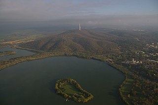
Springbank Island is an island located on Lake Burley Griffin in Canberra, Australian Capital Territory. Springbank Island is named after a former agricultural property that was partially submerged to create Lake Burley Griffin. An elevated part of the former property now comprises the island.

<span class="mw-page-title-main">Electorates of the Australian Capital Territory</span>

From 2016, the 25-member unicameral Australian Capital Territory Legislative Assembly is elected from five multi-member electorates, with five seats per electorate. Changes are made to the boundaries of each electorate prior to each general election.

<span class="mw-page-title-main">Parish of Queanbeyan</span> Cadastral in New South Wales, Australia

Queanbeyan Parish is a parish of Murray County, New South Wales, a cadastral unit for use on land titles. It covers the city of Queanbeyan. It was originally bounded by the Molonglo River to the north, but is now bounded by the NSW-ACT border in the north and west. Parts of the western area of the parish were transferred to the Australian Capital Territory in 1909, including what are now the Canberra suburbs of Fyshwick, Narrabundah, Kingston, Oaks Estate, Harman and part of Hume.

<span class="mw-page-title-main">Bombala railway line</span> Railway line in Australia

The Bombala railway line is a branch railway line in the south of New South Wales, Australia. The northern part of it forms part of the main line from Sydney to Canberra, but the southern part is closed. It branches off the Main South line at Joppa Junction, south of Goulburn. The line is used by NSW TrainLink Xplorer services running between Sydney Central and Canberra station.

Molonglo is a suburb currently under development in the Molonglo Valley district of Canberra, Australian Capital Territory, Australia. The suburb of Molonglo derives its name from an Aboriginal expression meaning "the sound of thunder".

Environa is a suburb and locality of Queanbeyan, located in the Queanbeyan–Palerang Regional Council, in New South Wales, Australia, west of Jerrabomberra Creek and nearby the New South Wales and Australian Capital Territory border. The development was described as a planned community, but it did not come to fruition. However, Environa has since been allocated as part of the South Jerrabomerra development of Queanbeyan for proposed development, including the proposed developments of Tralee and Poplars.

<span class="mw-page-title-main">Carwoola</span> Town in New South Wales, Australia

Carwoola is a locality in the state of New South Wales, Australia. It is immediately to the south of the Kowen district, which is located in the Australian Capital Territory. The Molonglo River passes through the Carwoola area before opening out into the Molonglo Plains. The Kings Highway and Captains Flat Road are the two major through routes. Carwoola is part of the Queanbeyan-Palerang Regional Council and the Southern Tablelands geographic area. The area also roughly aligns with the original Carwoola Parish.

<span class="mw-page-title-main">Denman Prospect, Australian Capital Territory</span> Suburb of Canberra, Australian Capital Territory

Denman Prospect is a suburb currently under development in the Molonglo Valley district of Canberra, located within the Australian Capital Territory, Australia.

<span class="mw-page-title-main">Beard, Australian Capital Territory</span> Suburb of Canberra, Australian Capital Territory

Beard is a suburb of Canberra in the District of Jerrabomberra, Australian Capital Territory, named after ex-convict Timothy Beard, the first recorded European settler in the vicinity of modern-day Queanbeyan.

<span class="mw-page-title-main">Jerrabomberra (district)</span> Place in Australian Capital Territory

Jerrabomberra is a district in the Australian Capital Territory in Australia. It is situated to the southeast of Canberra Central, south of the Molonglo River, east of Woden Valley and north east of Tuggeranong and west of the New South Wales border. It includes the suburbs of Beard, Hume, Oaks Estate and Symonston and the military communications and logistics facility HMAS Harman. At the 2016 census, it had a total population of 1,240, comprising 559 in Symonston, 430 in Hume and 251 in Oaks Estate and Beard At the 2011 census, 13 also lived in Harman. It is named after Jerrabomberra Creek, which runs through it, Jerrabomberra is derived from the Aboriginal word, meaning "afraid of lightning".

<span class="mw-page-title-main">Queanbeyan railway bridges over Queanbeyan and Molonglo Rivers</span> Bridge in New South Wales, Australia

The Queanbeyan railway bridges over Queanbeyan and Molonglo Rivers are two heritage-listed railway bridges that carry the Bombala railway line in the Queanbeyan-Palerang Region local government area of New South Wales, Australia. Both bridges were built between 1926 and 1927. The westernmost bridge crosses the Queanbeyan River from Queanbeyan to Queanbeyan East at 35.3424°S 149.2317°E, while the easternmost bridge crosses the Molonglo River at Burbong at 35.3371°S 149.3191°E. The two railway bridges are owned by Transport Asset Holding Entity, an agency of the Government of New South Wales. Together, the two bridges were added to the New South Wales State Heritage Register on 2 April 1999.

Strathnairn is a suburb in the Belconnen district of Canberra, located within the Australian Capital Territory, Australia. The suburb was gazetted in 2016 as part of the West Belconnen / Parkwood cross-border development near the Australian Capital Territory and New South Wales border.

References

  1. Australian Bureau of Statistics (28 June 2022). "Oaks Estate (suburb and locality)". Australian Census 2021 QuickStats. Retrieved 28 June 2022.  OOjs UI icon edit-ltr-progressive.svg
  2. 1 2 3 Monaro Consultants & Burnham Planning (2001), Oaks Estate Planning Study, ACT Government
  3. A fellmonger is someone who removes hair from animal hides in preparation for tanning
  4. 1 2 3 4 5 6 7 8 Savery N (2006), Public Place Names (Oaks Estate) Determination 2006 (No 1), ACT Parliamentary Counsel
  5. Williams, K (1997) 'Oaks Estate: No Man’s Land'. Published by Karen Williams, Canberra
  6. "Oaks Burial Ground - Australian Capitol Territory - Australia". www.interment.net.
  7. "Priority Enrolment Areas 2015 by Suburb" (Archived 14 February 2016 at the Wayback Machine ). Education Directorate, Australian Capital Territory. Retrieved 8 February 2016.
  8. Henderson, G. A. M.; Matveev, G. (1980). Geology of Canberra, Queanbeyan and Environs (Map). 1:50000.

Commons-logo.svg Media related to Oaks Estate, Australian Capital Territory at Wikimedia Commons