
Olson Mountain, also known as Mount Olson, is a 7,913-foot-elevation mountain summit located in the Livingston Range, of Glacier National Park in the U.S. state of Montana. Olson Mountain rises more than 3,700 feet (1,100 m) above the western shore of Waterton Lake. The mountain was named for a surveyor on the International Boundary Survey, with the name officially adopted in 1929. The nearest higher peak is Campbell Mountain, 1.13 miles (1.82 km) to the north, and Citadel Peaks is two miles to the south. Precipitation runoff from the mountain drains into Olson Creek before it empties to Waterton Lake.

Mount Noyes is a 3,080-metre (10,100-foot) mountain summit located in the Mistaya River valley of Banff National Park, in the Canadian Rockies of Alberta, Canada. Mount Noyes is situated at the confluence of Silverhorn Creek and Mistaya River, 3.5 km northwest of Mount Weed, and 9.2 km east of Howse Peak. Its nearest higher peak is Mount Patterson, 8.55 km (5.31 mi) to the south. Topographic relief is significant as it rises over 1,380 metres above the Icefields Parkway in two km.

Clyde Peak is an 8,610-foot-elevation (2,620-meter) mountain summit located in Glacier National Park in the U.S. state of Montana. The mountain straddles the border shared by Flathead County and Glacier County. It is situated on the Continental Divide so precipitation runoff from the west side of the mountain drains into Thompson Creek which is part of the Middle Fork Flathead River watershed, and the east side drains into headwaters of Red Eagle Creek, which flows to Red Eagle Lake, thence Saint Mary Lake. It is set in the Lewis Range, and the nearest higher neighbor is Mount Logan 1.44 mile to the northwest. Topographic relief is significant as the southwest aspect rises approximately 4,000 feet in one mile.

Spot Mountain is a 7,831-foot-elevation (2,387-meter) mountain summit located in the Two Medicine area of Glacier National Park, in Glacier County, Montana, United States. It is situated in the Lewis Range, nine miles northwest of East Glacier Park Village, and approximately five miles east of the Continental Divide. Precipitation runoff from the mountain drains into tributaries of Cut Bank Creek and Two Medicine River, which merge to form the Marias River. Topographic relief is significant as the south aspect rises nearly 3,000 feet above Lower Two Medicine Lake in two miles. The mountain's name was officially adopted in 1929 by the United States Board on Geographic Names.

Citadel Peaks is a mountain ridge located in the Goat Haunt area of Glacier National Park, in Glacier County of the U.S. state of Montana. This arête with a row of sharp points is part of the Livingston Range, and is approximately four miles east of the Continental Divide. Neighbors include Olson Mountain, two miles (3.2 km) to the north, Mount Cleveland four miles (6.4 km) to the east, and Kootenai Peak 2.7 miles (4.3 km) to the south. Topographic relief is significant as Citadel Peaks rises over 3,800 feet above Waterton Lake in less than two miles, and 3,000 feet above Lake Janet in one mile. Precipitation runoff from the mountain drains to the south end of Waterton Lake. The first ascent of Citadel Spire, a major pinnacle on the ridge, was made in 1967 by Jerry Kanzler, Jim Kanzler, Ray Martin, and Clare Pogreba. This geographical feature's name was officially adopted in 1929 by the United States Board on Geographic Names. To the Pikuni people, Citadel Peaks is known as "Ataniawxis", meaning "The Needles".

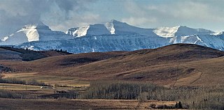
Argosy Mountain is an 8,155-foot (2,486-metre) summit located in Flathead County of the U.S. state of Montana.

Marmot Mountain is a 2,608-metre (8,556-foot) mountain summit located in Alberta, Canada.
Pyriform Mountain is a 2,739-metre (8,986-foot) mountain summit located 74 km (46 mi) southwest of Calgary in Kananaskis Country of Alberta, Canada. Pyriform Mountain is the third-highest officially named peak in the Highwood Range which is a subrange of the Canadian Rockies. Precipitation runoff from the mountain's west slope drains into headwaters of Junction Creek which is a tributary of the Sheep River; and the east slope drains to Trap Creek which is a tributary of the Highwood River. Topographic relief is modest as the summit rises approximately 740 metres (2,428 ft) above Junction Creek in 2 km (1.2 mi).

Nestor Peak is a 2,972-metre (9,751-foot) mountain summit located in Mount Assiniboine Provincial Park of British Columbia, Canada.

Indian Peak is a 2,992-metre (9,816-foot) mountain summit located in Mount Assiniboine Provincial Park of British Columbia, Canada.

Baldy Mountain is a 9,892-foot elevation (3,015 m) mountain summit on the common border shared by Beaverhead County, Montana, and Clark County, Idaho.

Black Mountain is a 10,941-foot (3,335-metre) summit located in Park County, Montana, United States.

Gardner Point is a 7,405-foot-elevation (2,257-meter) mountain summit in Flathead County, Montana.

Saint Paul Peak is a 7,714-foot-elevation (2,351-meter) mountain summit in Sanders County, Montana.

Rock Peak is a 7,583-foot-elevation (2,311-meter) mountain summit in Sanders County, Montana.

Engle Peak is a 7,583-foot-elevation (2,311-meter) mountain summit in Sanders County, Montana.

Elephant Peak is a 7,938-foot-elevation (2,420-meter) mountain summit located on the border shared by Lincoln and Sanders counties in Montana.

Flat Top Mountain is a 7,608-foot-elevation (2,319-meter) mountain summit located along the border shared by Lincoln and Sanders counties in Montana.

Ibex Peak is a 7,676-foot-elevation (2,340-meter) mountain summit in Sanders County, Montana.

A Peak is an 8,634-foot-elevation (2,632-meter) mountain summit located on the border shared by Lincoln and Sanders counties in Montana.


