
Washington County is located in the western part of the U.S. state of Maryland. As of the 2020 census, the population was 154,705. It is the most populous county in the Western Maryland region and its county seat is Hagerstown.

The National Road was the first major improved highway in the United States built by the federal government. Built between 1811 and 1837, the 620-mile (1,000 km) road connected the Potomac and Ohio Rivers and was a main transport path to the West for thousands of settlers. When improved in the 1830s, it became the second U.S. road surfaced with the macadam process pioneered by Scotsman John Loudon McAdam.

Boonsboro is a town in Washington County, Maryland, United States, located at the foot of South Mountain. It nearly borders Frederick County and is proximate to the Antietam National Battlefield. The population was 3,779 at the 2020 census.

Funkstown is a town in Washington County, Maryland, United States. The population was 904 at the 2010 census.

U.S. Route 40 or U.S. Highway 40 (US 40), also known as the Main Street of America, is a major east–west United States Highway traveling across the United States from the Mountain States to the Mid-Atlantic States. As with most routes whose numbers end in a zero, US 40 once traversed the entire United States. It is one of the first U.S. Highways created in 1926 and its original termini were in San Francisco, California, and Atlantic City, New Jersey. US 40 currently ends at a junction with I-80 in Silver Summit, Utah, just outside Salt Lake City. West of this point US 40 was functionally replaced with I-80, and as these segments of I-80 were constructed the western portion of US 40 was truncated several times.

U.S. Route 340 is a spur route of US 40, and runs from Greenville, Virginia, to Frederick, Maryland. In Virginia, it runs north–south, parallel and east of US 11, from US 11 north of Greenville via Waynesboro, Grottoes, Elkton, Luray, Front Royal, and Berryville to the West Virginia state line. A short separate piece crosses northern Loudoun County on its way from West Virginia to Maryland.

Western Maryland, also known as the Maryland panhandle, is the portion of the U.S. state of Maryland that typically consists of Washington, Allegany, and Garrett counties. The region is bounded by Preston County, West Virginia, to the west, the Mason–Dixon line (Pennsylvania) to the north, and the Potomac River and West Virginia to the south. At one point, at the town of Hancock, the northern and southern boundaries are separated by just 1.8 miles, the narrowest stretch in the state.

The Western Maryland Railway was an American Class I railroad (1852–1983) that operated in Maryland, West Virginia, and Pennsylvania. It was primarily a coal hauling and freight railroad, with a small passenger train operation.

Maryland Route 17 is a state highway in the U.S. state of Maryland. The state highway begins at the Virginia state line at the Potomac River in Brunswick, where the highway continues south as Virginia State Route 287. MD 17 runs 29.49 miles (47.46 km) north from the Brunswick Bridge to the Frederick–Washington county line near Wolfsville. The state highway serves as the main north–south highway of the Middletown Valley of western Frederick County. MD 17 connects Brunswick and Wolfsville with Rosemont, Burkittsville, Middletown, and Myersville. The state highway also connects those communities with the valley's main east–west highways, which include U.S. Route 340, US 40 Alternate, Interstate 70 (I-70), and US 40.

Maryland Route 144 is a collection of state highways in the U.S. state of Maryland. These highways are sections of old alignment of U.S. Route 40 between Cumberland and Baltimore. Along with US 40 Scenic, US 40 Alternate, and a few sections of county-maintained highway, MD 144 is assigned to what was once the main highway between the two cities, connecting those endpoints with Hancock, Hagerstown, Frederick, New Market, Mount Airy, Ellicott City, and Catonsville. MD 144 has seven disjoint sections of mainline highway that pass through the Appalachian Mountains in Allegany and Washington counties and the rolling Piedmont of Frederick, Carroll, Howard, and Baltimore counties.

Interstate 70 (I-70) is a part of the Interstate Highway System that runs from Cove Fort, Utah, to Woodlawn just outside of Baltimore, Maryland. In Maryland, the Interstate Highway runs 91.85 miles (147.82 km) from the Pennsylvania state line in Hancock east to the Interstate's eastern terminus at its junction with I-695. I-70 is the primary east–west Interstate in Maryland; the Interstate Highway connects Baltimore—and Washington, D.C., via I-270—with Western Maryland. The Interstate serves Frederick and Hagerstown directly and provides access to Cumberland via its junction with I-68 at Hancock. I-70 runs concurrently with its predecessor highway, U.S. Route 40 (US 40), from Hancock to Indian Springs in Washington County and from Frederick to West Friendship in Howard County.
U.S. Route 40 in the U.S. state of Maryland runs from Garrett County in Western Maryland to Cecil County in the state's northeastern corner. With a total length of 221 miles (356 km), it is the longest numbered highway in Maryland. Almost half of the road overlaps or parallels with Interstate 68 (I-68) or I-70, while the old alignment is generally known as US 40 Alternate, US 40 Scenic, or Maryland Route 144. West of Baltimore, in the Piedmont and Appalachian Mountains / Blue Ridge region of the Western Maryland panhandle of the small state, the portions where it does not overlap an Interstate highway are mostly two-lane roads. The portion northeast of Baltimore going toward Wilmington in northern Delaware and Philadelphia in southeastern Pennsylvania is a four-lane divided highway, known as the Pulaski Highway. This section crosses the Susquehanna River at the north end of the Chesapeake Bay on the Thomas J. Hatem Memorial Bridge.

U.S. Route 11 (US 11) is a part of the United States Numbered Highway System that runs from New Orleans, Louisiana, to Rouses Point, New York. In Maryland, the federal highway runs 12.83 miles (20.65 km) from the West Virginia state line at the Potomac River in Williamsport north to the Pennsylvania state line near Maugansville. US 11 is the primary north–south surface highway in central Washington County, connecting Hagerstown with Williamsport to the south and Hagerstown Regional Airport to the north. The federal highway was once a major long-distance highway, but that role has been assumed by Interstate 81 (I-81), which parallels US 11 not only in Maryland but for most of its course from Tennessee to Upstate New York. US 11 is maintained by the Maryland State Highway Administration except for the municipally-maintained portions within the corporate limits of Williamsport and Hagerstown.
The Hagerstown and Frederick Railway, now defunct, was an American railroad of central Maryland built in the 19th and 20th centuries.
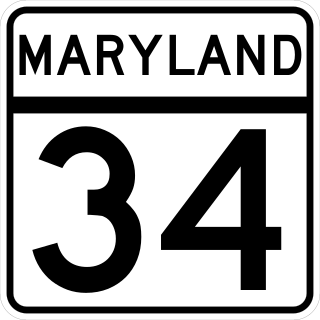
Maryland Route 34 is a state highway in the U.S. state of Maryland. Known for most of its length as Shepherdstown Pike, the state highway begins at the West Virginia state line at the Potomac River, where the highway continues south as West Virginia Route 480 through Shepherdstown. The state highway runs 9.95 miles (16.01 km) east to U.S. Route 40 Alternate in Boonsboro. MD 34 is the main east–west highway of southern Washington County, connecting Shepherdstown and Boonsboro with Sharpsburg and Keedysville. The state highway, which was preceded by the Boonsboro and Sharpstown Turnpike, was constructed as a modern highway in the late 1910s and early 1920s. MD 34's bypass of Keedysville opened around 1960. The western end of the state highway has had three bridges. A 19th-century bridge was destroyed in a 1936 flood and replaced by the James Rumsey Bridge in 1939. The present bridge, also named for James Rumsey, opened in 2005.

Maryland Route 68 is a state highway in the U.S. state of Maryland. The state highway runs 18.50 miles (29.77 km) from U.S. Route 40 in Clear Spring east to US 40 Alternate in Boonsboro. MD 68 crosses central Washington County to the south of Hagerstown, connecting Clear Spring and Boonsboro with Williamsport, where the highway runs concurrently with MD 63. A small segment of MD 68 west of Boonsboro was constructed around 1920, using as part of the route two early 19th-century stone bridges. The remainder of the highway between Boonsboro and Williamsport was constructed in the second half of the 1920s. MD 68 was extended west from Williamsport to Clear Spring in the mid-1950s. The state highway was relocated south of Williamsport for the construction of Interstate 81 (I-81) in the mid-1960s. Since the early 1990s, I-68 has also existed in Washington County; signs on I-70 aim to avoid confusion between I-68 and MD 68.
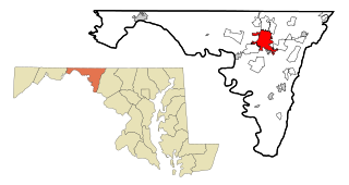
Hagerstown is a city in and the county seat of Washington County, Maryland, United States. The population was 43,527 at the 2020 census. Hagerstown ranks as Maryland's sixth-most populous incorporated city and is the most populous city in the Maryland Panhandle.
Boonsboro Historic District is a national historic district at Boonsboro, Washington County, Maryland, United States. The district includes 562 contributing elements. Its component buildings chronicle the town's development from its founding in 1792 through the mid 20th century. Most of the late 18th and early 19th century development in Boonsboro occurred along Main Street, then part of a principal market road between Williamsport, Hagerstown, Frederick, and Baltimore, Maryland. They are mainly of log, frame, or brick construction, with a few stone buildings interspersed. The majority of the buildings in the district date from the 1820-1850 period coinciding with peak use years of the National Road. Other features of the district include the Boonsboro Cemetery laid out about 1855 in a 19th-century curving plan with a number of exceptionally artistic gravestones, and the office/depot of the Hagerstown-Boonsboro Electric Railway. The period of significance, from 1792 to 1959 tracks the continuous growth and evolution of the town through the date by which the district had substantially achieved its current form and appearance.
U.S. Route 40 Alternate (US 40 Alternate) is an alternate route of US 40 in the U.S. state of Maryland. The highway runs 22.97 miles (36.97 km) from Potomac Street in Hagerstown east to US 40 in Frederick. US 40 Alternate parallels US 40 and much of Interstate 70 (I-70) to the south through eastern Washington County and western Frederick County. The alternate route connects Hagerstown and Frederick with Funkstown, Boonsboro, Middletown, and Braddock Heights. US 40 Alternate crosses two major north–south components of the Blue Ridge Mountains that separate the Great Appalachian Valley and the Piedmont: South Mountain between Boonsboro and Middletown and Catoctin Mountain, which is locally known as Braddock Mountain, at Braddock Heights.


