Olti okrug

Last updated
Olti okrug
Ольтинскій округъ
Coat of arms of Kars Oblast 1881.svg
Olti Okrug of Kars Oblast.png
Location in the Kars Oblast
Country Russian Empire
Viceroyalty Caucasus
Oblast Kars
Established1878
Treaty of Brest-Litovsk 3 March 1918
CapitalOlty
(present-day Oltu)
Area
  Total2,983.17 km2 (1,151.81 sq mi)
Population
 (1914)
  Total40,091
  Density13/km2 (35/sq mi)
   Urban
8.13%
   Rural
91.87%

The Olti okrug [lower-alpha 1] was a district ( okrug ) of the Kars Oblast of the Russian Empire existing between 1878 and 1918. Its capital was the town of Olty (present-day Oltu), presently part of the Erzurum Province of Turkey. The okrug bordered with the Kars okrug to the southeast, the Ardahan okrug to the northwest, the Kagizman okrug to its south, the Batum Oblast to the north, and the Erzurum vilayet of the Ottoman Empire to the west. [1]

Contents

History

The Olti okrug was one of the four territorial administrative subunits (counties) of the Kars Oblast created after its annexation into the Russian Empire in 1878 through the Treaty of San Stefano, following the defeat of the Ottoman Empire. [2]

During the First World War, the Kars oblast became the site of intense battles between the Russian Caucasus Army supplemented by Armenian volunteers and the Ottoman Third Army, the latter of whom was successful in briefly occupying Ardahan on 25 December 1914 before they were dislodged in early January 1915.

On 3 March 1918, in the aftermath of the October Revolution the Russian SFSR ceded the entire Kars Oblast including the Olti okrug through the Treaty of Brest-Litovsk to the Ottoman Empire, who had been unreconciled with its loss of the territory since 1878. Despite the ineffectual resistance of the Transcaucasian Democratic Federative Republic which had initially rejected the aforementioned treaty, the Ottoman Third Army was successful in occupying the Kars Oblast and forcefully expelling its 100,000 panic-stricken Armenian inhabitants. [3]

The Ottoman Ninth Army under the command of Yakub Shevki Pasha, the occupying force of the district by the time of the Mudros Armistice, were permitted to winter in Kars until early 1919, after which on 7 January 1919 Major General G.T. Forestier-Walker ordered their complete withdrawal to the pre-1914 Ottoman-frontier. Intended to hinder the westward expansion of the fledgling Armenian and Georgian republics into the Kars Oblast, Yukub Shevki backed the emergence of the short-lived South-West Caucasus Republic with moral support, also furnishing it with weapons, ammunition and instructors. [4]

The South-West Caucasus Republic administered the Olti okrug and neighboring formerly occupied districts for three months before provoking British intervention by order of General G.F. Milne, leading to its capitulation by Armenian and British forces on 10 April 1919. [5] [6] Consequently, the Kars Oblast largely came under the Armenian civil governorship of Stepan Korganian who wasted no time in facilitating the repatriation of the region's exiled refugees. [7]

Despite the apparent defeat of the Ottoman Empire, Turkish agitators were reported by Armenian intelligence to have been freely roaming the countryside of Kars encouraging sedition among the Muslim villages, culminating in a series of anti-Armenian uprisings on 1 July 1919. [8]

The Kars Oblast for the third time in six years saw invading Turkish troops, this time under the command of General Kâzım Karabekir in September 1920 during the Turkish-Armenian War. The disastrous war for Armenia resulted in the permanent expulsion of the region's ethnic Armenian population, many who inexorably remained befalling massacre, resulting in the region joining the Republic of Turkey through the Treaty of Alexandropol on 3 December 1920. Turkey's annexation of Kars and the adjacent Surmalu Uyezd was confirmed in the treaties of Kars and Moscow in 1921, by virtue of the new Soviet regime in Armenia. [9]

Administrative divisions

The subcounties ( uchastoks ) of the Olti okrug were: [10]

Name1912 populationArea
Oltinskiy uchastok (Ольтинскій участокъ)10,8741,888.85 square versts (2,149.63  km2 ; 829.98  sq mi )
Tauskerskiy uchastok (Таускерскій участокъ)6,400732.42 square versts (833.54  km2 ; 321.83  sq mi )

Demographics

Russian Empire Census

According to the Russian Empire Census, the Olti okrug had a population of 31,519 on 28 January [ O.S. 15 January] 1897, including 16,845 men and 14,674 women. The majority of the population indicated Turkish to be their mother tongue, with significant Kurdish, Armenian, and Greek speaking minorities. [11]

Linguistic composition of the Olti okrug in 1897 [11]
LanguageNative speakers%
Turkish 19,71962.56
Kurdish 3,50511.12
Armenian 3,1259.91
Greek 2,7048.58
Turkmen 9993.17
Russian 8702.76
Ukrainian 1680.53
Ossetian 620.20
Polish 480.15
Persian 440.14
Georgian 200.06
Avar-Andean 110.03
Dargin 80.03
German 70.02
Tatar [lower-alpha 2] 40.01
Karapapakh 10.00
Other2240.71
TOTAL31,519100.00

Kavkazskiy kalendar

According to the 1915 publication of Kavkazskiy kalendar , the Olti okrug had a population of 40,091 on 14 January [ O.S. 1 January] 1914, including 20,540 men and 19,551 women, 37,553 of whom were the permanent population, and 2,538 were temporary residents. The statistics indicated the town Olti to be overwhelmingly ethnic Armenian in population with a sizeable Yazidi minority, conversely, the rest of the okrug was mainly Yazidi, with sizeable Kurdish, Georgian, Asiatic Christian, and Armenian minorities: [14]

Nationality Urban Rural TOTAL
Number%Number%Number%
Yazidis 45814.0621,30957.8521,767[ sic ]54.29
Kurds 511.575,12813.925,17912.92
Armenians 2,18867.162,7657.514,95312.35
Georgians 782.394,01710.914,095[ sic ]10.21
Asiatic Christians 00.003,4549.383,4548.62
Russians 1775.43240.072010.50
Roma 1344.1100.001340.33
North Caucasians 631.93610.171240.31
Jews 00.00720.20720.18
Shia Muslims [lower-alpha 3] 581.7830.01610.15
Sunni Muslims [lower-alpha 4] 511.5700.0051[ sic ]0.13
TOTAL3,258100.0036,833100.0040,091100.00

Comparing with previous years' statistics and considering that the district was predominantly Turkish-majority, it is likely that the 1915 publication of the Caucasian Calendar, mistakenly put the number of Sunni Muslims (mainly Turks) in the Yazidis column. The large number of Georgians compared with previous years is also exceptional and likely to be another printing error.

Settlements

According to the 1897 census, there were 10 settlements in the Olti okrug with a population over 500 inhabitants. The religious composition of the settlements was as follows: [16]

Name Armenian Apostolic Muslim Eastern Orthodox MaleFemaleTOTAL
Gaziler (Бардус (Бардуз), Bardus (Barduz))519280260540
Ormanağzı (Каранаваз (Карнаваз), Karanavaz (Karnavaz))799401400801
Nişantaşı (Кейванк, Keyvank)499270229499
Ünlükaya (Нариман (Нориман Греческое), Nariman (Noriman Grecheskoye))497267239506
Oltu (Ольты, Olty)1,056 [lower-alpha 5] 4058411,6337402,373
Atlı (Ори, Ori)783394389783
Şenkaya (Ортули (Ортулу), Ortuli (Ortulu))627335297632
Yukarıkaracasu (Панаскерт Верхний, Panaskert Verkhniy)516269247516
Aşağıkaracasu (Панаскерт Нижний, Panaskert Nizhniy)764406358764
Çataksu (Таускер (Тавискар), Tausker (Taviskar))694379315694
TOTAL1,0565,0871,8574,6343,4748,108

Notes

  1. Prior to 1918, Azerbaijanis were generally known as "Tatars". This term, employed by the Russians, referred to Turkic-speaking Muslims of the South Caucasus. After 1918 with the establishment of the Azerbaijan Democratic Republic, and "especially during the Soviet era", the Tatar group identified itself as "Azerbaijani". [12] [13]
  2. Primarily Tatars. [15]
  3. Primarily Turco-Tatars. [15]
  4. Includes Armenian Catholics.

Related Research Articles

Kars <i>oblast</i> Oblast in Caucasus, Russian Empire

The Kars oblast was a province (oblast) of the Caucasus Viceroyalty of the Russian Empire between 1878 and 1917. Its capital was the city of Kars, presently in Turkey. The oblast bordered the Ottoman Empire to the west, the Batum Oblast to the north, the Tiflis Governorate to the northeast, and the Erivan Governorate to the east. The Kars oblast included parts of the contemporary provinces of Kars, Ardahan, and Erzurum Province of Turkey, and the Amasia Community of the Shirak Province of Armenia.

Batum <i>oblast</i> Oblast of the Russian Empire

The Batum oblast was a province (oblast) of the Caucasus Viceroyalty of the Russian Empire, with the Black Sea port of Batum as its administrative center. The Batum oblast roughly corresponded to most of present-day southwestern Georgia, and part of the Artvin Province of Turkey.

Surmalu <i>uezd</i> Uezd in Caucasus, Russian Empire

The Surmalu uezd was a county (uezd) of the Erivan Governorate of the Caucasus Viceroyalty of the Russian Empire. It bordered the governorate's Etchmiadzin and Erivan uezds to the north, the Kars Oblast to the west, Persia to the east, and the Ottoman Empire to the south. The district made up most of the Iğdır Province of present-day Turkey. As part of the Russian Transcaucasus, the Surmalu uezd possessed economical importance for its abundantly rich salt mines in Kulp (Tuzluca), and spiritual importance to Armenians as the location of the culturally significant Mount Ararat. The administrative centre of the county was Igdyr.

Kars <i>okrug</i> Okrug in Caucasus, Russian Empire

The Kars okrug was a district (okrug) of the Kars Oblast of the Russian Empire between 1878 and 1918. Its capital was the city of Kars, presently part of the Kars Province of Turkey and the Amasia District of Armenia. The okrug bordered with the Ardahan okrug in the north, the Kagizman okrug in the south, the Olti okrug in the west, and the Erivan Governorate to its east.

Ardahan <i>okrug</i> Okrug in Caucasus, Russian Empire

The Ardahan okrug was a district (okrug) of the Kars Oblast of the Russian Empire between 1878 and 1918. The district was eponymously named for its administrative center, the town of Ardagan, presently part of the Ardahan Province of Turkey. The okrug bordered with the Kars okrug to the south, the Olti okrug in the west, the Batum Oblast in the north, the Tiflis Governorate in the northeast, and from 1883 to 1903 the Kutais Governorate whilst the latter included the Artvin and Batum okrugs.

Kagizman <i>okrug</i> Okrug in Caucasus, Russian Empire

The Kagizman okrug was a district (okrug) of the Kars Oblast of the Russian Empire, existing between 1878 and 1918. Its capital was the town of Kagyzman, presently in the Kars Province of Turkey. The okrug bordered with the Kars okrug to the north, the Olti okrug to the northwest, the Erivan Governorate to the east, and the Erzurum Vilayet of the Ottoman Empire to the west.

Akhalkalaki <i>uezd</i> Uezd in Caucasus, Russian Empire

The Akhalkalaki uezd was a county (uezd) of the Tiflis Governorate of the Caucasus Viceroyalty of the Russian Empire, and then of Democratic Republic of Georgia, with its administrative centre in Akhalkalak. The county bordered the Gori uezd to the north, the Borchaly uezd to the east, the Alexandropol uezd of the Erivan Governorate and the Kars and Ardahan okrugs of the Kars Oblast to the south, and the Akhaltsikhe uezd to the west. The area of the county roughly corresponded to the contemporary Samtskhe–Javakheti region of Georgia.

Akhaltsikhe <i>uezd</i> Uezd in Caucasus, Russian Empire

The Akhaltsikhe uezd was a county (uezd) of the Tiflis Governorate of the Caucasus Viceroyalty of the Russian Empire, and then of Democratic Republic of Georgia, with its administrative center in Akhaltsikh. The uezd bordered the Gori uezd and the Kutaisi Governorate to the north, the Akhalkalaki uezd to the east, the Ardahan Okrug of the Kars Oblast to the south, and the Batum Okrug of the Batum Oblast to the west. The area of the uezd roughly corresponded to the contemporary Samtskhe-Javakheti region of Georgia.

Artvin <i>okrug</i> Okrug in Caucasus, Russian Empire

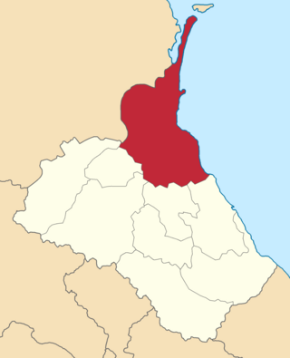
The Artvin okrug was a district (okrug) of the Batum Oblast of the Russian Empire, existing between 1878 and 1918. The district was eponymously named for its administrative centre, Artvin, presently part of the Artvin Province of Turkey. The district bordered with the Olti okrug to the south, the Ardahan okrug to the east, the Batumi okrug to the north, and the Ottoman Empire to the west. Between 1883 and 1903, the Artvin okrug formed a part of the Kutaisi Governorate.

Batumi <i>okrug</i> Okrug in Caucasus, Russian Empire

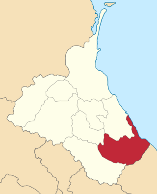
The Batumi okrug was a district (okrug) of the Batum Oblast of the Russian Empire existing between 1878 and 1918. The district was eponymously named for its administrative center, the town of Batum, now part of Adjara within Georgia. The okrug bordered with the Artvin okrug in the south, the Ardahan okrug of the Kars Oblast to the southeast, the Tiflis Governorate to the northeast, the Kutaisi Governorate to the north, and the Trebizond Vilayet of the Ottoman Empire to the west.

Batalpashinsky <i>otdel</i> Otdel in Caucasus, Russian Empire

The Batalpashinsky otdel was a Cossack district of the Kuban oblast of the Caucasus Viceroyalty of the Russian Empire. It bordered the Stavropol Governorate to the north, the Labinsky and Maykopsky otdels to the west, the Sochi and Sukhumi okrugs to the south, and the Terek Oblast to the east. The area of the Batalpashinsky otdel included most of the contemporary Karachay-Cherkessia region of Russia. The administrative capital was the city of Batalpashinskaya.

<i>Avarsky okrug</i> Okrug in Caucasus, Russian Empire

The Avarsky okrug was a district (okrug) of the Dagestan Oblast of the Caucasus Viceroyalty of the Russian Empire. The area of the Avarsky okrug is included in contemporary Dagestan of the Russian Federation. The district's administrative centre was Khunzakh.

<i>Andiysky okrug</i> Okrug in Caucasus, Russian Empire

The Andiysky okrug was a district (okrug) of the Dagestan Oblast of the Caucasus Viceroyalty of the Russian Empire. The area of the Andiysky okrug is included in contemporary Dagestan of the Russian Federation. The district's administrative centre was Botlikh.

<i>Gunibsky okrug</i> Okrug in Caucasus, Russian Empire

The Gunibsky okrug was a district (okrug) of the Dagestan Oblast of the Caucasus Viceroyalty of the Russian Empire. The area of the Gunibsky okrug is included in contemporary Dagestan of the Russian Federation. The district's centre was Gunib.

<i>Kazikumukhsky okrug</i> Okrug in Caucasus, Russian Empire

The Kazikumukhsky okrug was a district (okrug) of the Dagestan Oblast of the Caucasus Viceroyalty of the Russian Empire. The area of the Kazikumukhsky okrug is included in contemporary Dagestan of the Russian Federation. The district's administrative centre was Kumukh.

<i>Kyurinsky okrug</i> Okrug in Caucasus, Russian Empire

The Kyurinsky okrug was a district (okrug) of the Dagestan Oblast of the Caucasus Viceroyalty of the Russian Empire. The area of the Kyurinsky okrug is included in contemporary Dagestan of the Russian Federation. The district's administrative centre was Kasumkent.

<i>Samursky okrug</i> Okrug in Caucasus, Russian Empire

The Samursky okrug was a district (okrug) of the Dagestan Oblast of the Caucasus Viceroyalty of the Russian Empire. The area of the Samursky okrug is included in contemporary Dagestan of the Russian Federation. The district's administrative centre was Akhty.

<i>Temir-Khan-Shurinsky okrug</i> Okrug in Caucasus, Russian Empire

The Temir-Khan-Shurinsky okrug was a district (okrug) of the Dagestan Oblast of the Caucasus Viceroyalty of the Russian Empire. The area of the Temir-Khan-Shurinsky okrug is included in contemporary Dagestan of the Russian Federation. The district's administrative centre was Temir-Khan-Shura.

<i>Vedensky okrug</i> Okrug in Caucasus, Russian Empire

The Vedensky okrug was a district (okrug) of the Terek Oblast of the Caucasus Viceroyalty of the Russian Empire. The area of the Vedensky okrug made up part of the North Caucasian Federal District of Russia. The district was eponymously named for its administrative centre, Vedeno.

Pyatigorsky <i>otdel</i> Otdel in Caucasus, Russian Empire

The Pyatigorsky otdel was a Cossack district of the Terek oblast of the Caucasus Viceroyalty of the Russian Empire. The area of the Pyatigorsky otdel makes up part of the North Caucasian Federal District of Russia. The district was eponymously named for its administrative center, Pyatigorsk.

References

  1. Tsutsiev 2014.
  2. "КАРССКАЯ ОБЛАСТЬ — информация на портале Энциклопедия Всемирная история". w.histrf.ru. Retrieved 2021-12-05.
  3. Hovannisian, Richard G. (1971–1996). The Republic of Armenia. Berkeley: University of California Press. p. 27. ISBN   0-520-01805-2. OCLC   238471.
  4. Hovannisian, Richard G. (1971–1996). The Republic of Armenia. Berkeley: University of California Press. p. 201. ISBN   0-520-01805-2. OCLC   238471.
  5. Andersen, Andrew. "Armenia in the Aftermath of Mudros: Conflicting claims and Strife with the Neighbors".{{cite web}}: CS1 maint: url-status (link)
  6. Hovannisian, Richard G. (1971–1996). The Republic of Armenia. Berkeley: University of California Press. p. 220. ISBN   0-520-01805-2. OCLC   238471.
  7. Hovannisian, Richard G. (1971–1996). The Republic of Armenia. Berkeley: University of California Press. p. 204. ISBN   0-520-01805-2. OCLC   238471.
  8. Hovannisian, Richard G. (1971–1996). The Republic of Armenia. Berkeley: University of California Press. p. 66. ISBN   0-520-01805-2. OCLC   238471.
  9. De Waal, Thomas (2015). Great catastrophe : Armenians and Turks in the shadow of genocide. Oxford. p. 86. ISBN   978-0-19-935070-4. OCLC   897378977.
  10. Кавказский календарь на 1913 год, pp. 156–163.
  11. 1 2 "Демоскоп Weekly - Приложение. Справочник статистических показателей". www.demoscope.ru. Retrieved 2022-03-26.
  12. Bournoutian 2018, p. 35 (note 25).
  13. Tsutsiev 2014, p. 50.
  14. Кавказский календарь на 1915 год, pp. 234–237.
  15. 1 2 Hovannisian 1971, p. 67.
  16. Troinitsky, N. A. (1905). Населенные места Российской империи в 500 и более жителей с указанием всего наличного в них населения и числа жителей преобладающих вероисповеданий, по данным первой всеобщей переписи населения 1897 г. [Populated areas of the Russian Empire with 500 or more inhabitants, indicating the total population in them and the number of inhabitants of the predominant religions, according to the first general population census of 1897] (in Russian). Saint Petersburg: Tipografiya Obshchestvennaya polza. pp. 33–34. Archived from the original on 10 August 2022.

Bibliography

40°32′59″N41°59′59″E / 40.54972°N 41.99972°E / 40.54972; 41.99972