
Oxoboxo River is a census-designated place (CDP) in the town of Montville in New London County, Connecticut, United States. The population was 2,938 at the 2000 census, 3,165 at the 2010 census, and 2,955 at the 2020 census. The statistical area encompasses the town center of Montville, as well as the adjacent villages of Palmertown and Uncasville. The name of the statistical area is from the river of the same name running through the CDP.

Lockhart is a census-designated place in Orange County, Florida, United States. The population was 13,060 at the 2010 census. It is part of the Orlando–Kissimmee–Sanford, Florida Metropolitan Statistical Area. The community is named for David Lockhart.

Baldwinville is an unincorporated village and census-designated place (CDP) in the town of Templeton in Worcester County, Massachusetts, United States. The population was 2,028 at the 2010 census. The name also refers to the local post office or railroad station.

Red Lake is a census-designated place (CDP) within the Lower Red Lake unorganized territory located in Beltrami County, Minnesota, United States. As of the 2020 census, Red Lake had a total population of 1,786. The Red Lake Indian Reservation is based in Red Lake.

Onondaga is a town in Onondaga County, New York, United States, encompassing 65 square miles. As of the 2020 Census, the population was 22,937. The town is named after the native Onondaga tribe, part of the Iroquois Confederacy. Onondaga was incorporated April 2, 1798, and is located southwest of the city of Syracuse, which it borders. The villages and hamlets which make up the town are: Cedarvale, Howlett Hill, Navarino, Nedrow, Onondaga Hill, Sentinel Heights, South Onondaga, Southwood, Split Rock, and Taunton.

Harrisville is a census-designated place (CDP) and village in the town of Burrillville in Providence County, Rhode Island, United States. The population was 1,605 at the 2010 census. Much of the community composes a historic district listed on the National Register of Historic Places. The village was named after nineteenth century manufacturer Andrew Harris. Previously, the village was named Rhodesville, after Captain William Rhodes, an eighteenth century privateer.

Ashaway is an unincorporated village and census-designated place (CDP) in the town of Hopkinton, Rhode Island, USA. It is a principal village of Hopkinton, along with Hope Valley, although it is the smaller of the two. The population was 1,485 at the 2010 census. The name Ashaway is derived from the American Indian name for the river that runs through the village, the Ashawague or Ashawaug, which means "land in the middle" or "land between" in the Niantic and Mohegan languages. The name "Ashawague River" appears as late as 1832 on the Findley map of Rhode Island published in Philadelphia.

Wakefield-Peacedale is a census-designated place (CDP) in the town of South Kingstown in Washington County, Rhode Island, United States that includes the villages of Peace Dale and Wakefield. The population was 8,487 at the 2010 census.

Passamaquoddy Indian Township Reservation is one of two Indian reservations of the federally recognized Passamaquoddy tribe in Washington County, Maine, United States. The population was 760 at the 2020 census. Most of the 2,500 members of the tribe in the United States live in other parts of Maine. The reservation is located about 13 miles west-northwest of the city of Calais.

Allegany Reservation is a Seneca Nation of Indians reservation in Cattaraugus County, New York, U.S. In the 2000 census, 58 percent of the population within the reservation boundaries were Native Americans. Some 42% were European Americans; they occupy properties under leases from the Seneca Nation, a federally recognized tribe. The population outside of the rented towns was 1,020 at the 2010 census. The reservation's Native American residents are primarily members of the Seneca, but a smaller number of Cayuga, another Iroquois nation, also reside there, and at least one family is known to have descended from the Neutral Nation. Prior to the 17th century, this area was occupied by the Iroquoian-speaking Wenrohronon and Eriehronon. The more powerful Seneca eliminated these competing groups during the Beaver Wars beginning in 1638, as the Iroquois Confederacy sought to control the lucrative fur trade with the French and Dutch colonists.

The Tuscarora Reservation is an Indian reservation in Niagara County, New York. The population was 1,152 at the 2010 census. The Tuscarora are a federally recognized tribe and the Sixth Nation of the Haudenosaunee or Iroquois Confederacy active before the American Revolutionary War.
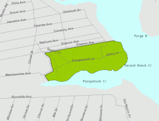
The Poospatuck Reservation is a Native American reservation of the Unkechaugi band in the community of Mastic, Suffolk County, New York, United States. It is one of two Native American reservations in Suffolk County, the other being the Shinnecock Reservation. The population was 436 at the 2020 census.

Shinnecock Reservation is a Native American reservation for members of the Shinnecock Indian Nation in the town of Southampton in Suffolk County, New York, United States. It is the furthermost east of the two Native American reservations in Suffolk County; the other being Poospatuck Reservation in the town of Brookhaven. It lies on the east side of Shinnecock Bay on southeastern Long Island, near Tuckahoe, Shinnecock Hills, and the village of Southampton. The population was 819 as of the 2020 census. Roughly that many tribal members additionally live off the reservation.
Cattaraugus Reservation is an Indian reservation located partly in Cattaraugus County, New York, United States. The population was 314 at the 2010 census. The majority of the residents are of the federally recognized Seneca Nation, one of the original Five Nations of the Iroquois Confederacy.
The Cattaraugus Reservation is an Indian reservation of the Seneca Nation of New York, located partly in Chautauqua County, New York, United States. The population of this portion of the reservation was 38 at the 2010 census. Most of the inhabitants are of the Seneca tribe.

Cattaraugus Reservation is an Indian reservation located partly in Erie County, New York, United States. The population was 1,833 at the 2010 census.

The Tonawanda Indian Reservation is an Indian reservation of the Tonawanda Seneca Nation located in western New York, United States. The band is a federally recognized tribe and, in the 2010 census, had 693 people living on the reservation. The reservation lies mostly in Genesee County, extending into Erie and Niagara counties. It is bordered by the Towns of Alabama, Pembroke, Newstead, and Royalton.
Duxbury is a census-designated place (CDP) in the town of Duxbury in Plymouth County, Massachusetts, United States. The population was 1,802 at the 2010 census.

Winchendon is a census-designated place (CDP) in the town of Winchendon in Worcester County, Massachusetts, United States. The population was 4,160 at the 2020 census.
Seymour is a census-designated place (CDP) in Eau Claire County, Wisconsin, United States. The population was 1,418 at the 2010 census. It is located within the town of Seymour and is part of the Eau Claire urban area.

