Village Green, New York

Last updated
Village Green, New York
Onondaga County New York incorporated and unincorporated areas Village Green highlighted.svg
Location in Onondaga County and the state of New York.
Coordinates: 43°7′54″N76°18′31″W / 43.13167°N 76.30861°W / 43.13167; -76.30861 Coordinates: 43°7′54″N76°18′31″W / 43.13167°N 76.30861°W / 43.13167; -76.30861
Country United States
State New York
County Onondaga
Area
[1]
  Total1.16 sq mi (3.01 km2)
  Land1.15 sq mi (2.99 km2)
  Water0.01 sq mi (0.02 km2)
Elevation
440 ft (134 m)
Population
 (2020)
  Total3,834
  Density3,322.36/sq mi (1,282.84/km2)
Time zone UTC-5 (Eastern (EST))
  Summer (DST) UTC-4 (EDT)
FIPS code 36-77513
GNIS feature ID1867421

Village Green is a hamlet (and census-designated place) in Onondaga County, New York, United States. The population was 3,891 at the 2010 census.

Contents

Village Green is in the eastern part of the town of Van Buren.

Geography

Village Green is located at 43°7′54″N76°18′31″W / 43.13167°N 76.30861°W / 43.13167; -76.30861 (43.131717, -76.308592). [2]

According to the United States Census Bureau, the region has a total area of 1.2 square miles (3.1 km2), all land.

The village is south of the Seneca River and southeast of Baldwinsville.

Most of the community is between Interstate 690 and New York State Route 48.

Demographics

Historical population
CensusPop.
2020 3,834
U.S. Decennial Census [3]

As of the census [4] of 2000, there were 3,945 people, 1,896 households, and 1,033 families residing in the community. The population density was 3,227.6 per square mile (1,248.5/km2). There were 2,053 housing units at an average density of 1,679.7/sq mi (649.7/km2). The racial makeup of the CDP was 96.76% White, 1.04% African American, 0.23% Native American, 0.74% Asian, 0.33% from other races, and 0.91% from two or more races. Hispanic or Latino of any race were 1.14% of the population.

There were 1,896 households, out of which 24.2% had children under the age of 18 living with them, 41.7% were married couples living together, 9.8% had a female householder with no husband present, and 45.5% were non-families. 38.4% of all households were made up of individuals, and 10.0% had someone living alone who was 65 years of age or older. The average household size was 2.08 and the average family size was 2.78.

In the CDP, the population was spread out, with 20.9% under the age of 18, 6.3% from 18 to 24, 35.2% from 25 to 44, 25.1% from 45 to 64, and 12.4% who were 65 years of age or older. The median age was 38 years. For every 100 females, there were 88.8 males. For every 100 females age 18 and over, there were 86.7 males.

The median income for a household in the CDP was $43,243, and the median income for a family was $50,278. Males had a median income of $36,686 versus $29,519 for females. The per capita income for the CDP was $23,559. About 5.9% of families and 6.2% of the population were below the poverty line, including 9.8% of those under age 18 and 6.1% of those age 65 or over.

Related Research Articles

<span class="mw-page-title-main">Indian River Estates, Florida</span> CDP in Florida, United States

Indian River Estates is a census-designated place (CDP) in St. Lucie County, Florida, United States. The population was 6,220 at the 2010 census. It is part of the Port St. Lucie Metropolitan Statistical Area.

<span class="mw-page-title-main">Kualapuu, Hawaii</span> Census-designated place in Hawaii, United States

Kualapuʻu is a census-designated place (CDP) on the island of Molokai in Maui County, Hawaiʻi, United States. The population was 2,110 at the 2020 census. Kualapuʻu can be literally translated as "hill overturned", but is thought to be a corruption of Puʻuʻuala: "sweet potato hill". The present settlement is a former pineapple cannery village once associated with Del Monte Foods.

<span class="mw-page-title-main">Wareham Center, Massachusetts</span> Census-designated place in Massachusetts, United States

Wareham Center is a census-designated place (CDP) in the town of Wareham in Plymouth County, Massachusetts, United States. The population was 2,896 at the 2010 census.

Adams Center is a hamlet and census-designated place (CDP) in the town of Adams in Jefferson County, New York, United States. The population was 1,492 during the 2020 decennial census.

<span class="mw-page-title-main">Galeville, New York</span> Census-designated place in New York, United States

Galeville is a hamlet in Onondaga County, New York, United States. The population was 4,617 at the 2010 census.

<span class="mw-page-title-main">Mattydale, New York</span> Census-designated place in New York, United States

Mattydale is a hamlet in Onondaga County, New York, United States. The population was 6,446 at the 2010 census.

<span class="mw-page-title-main">Seneca Knolls, New York</span> Census-designated place in New York, United States

Seneca Knolls is a hamlet in Onondaga County, New York, United States. The population was 2,011 at the 2010 census.

<span class="mw-page-title-main">Sand Ridge, New York</span> CDP in New York, United States

Sand Ridge is a hamlet in Oswego County, New York, United States. The population was 849 at the 2010 census.

Newfield is a census-designated place (CDP) in Tompkins County, New York, United States. The population was 759 at the 2010 census.

Whitfield is a census-designated place (CDP) in Berks County, Pennsylvania, United States. The population was 4,733 at the 2010 census.

Forestville is a census-designated place (CDP) in Schuylkill County, Pennsylvania, United States. The population was 431 at the 2000 census.

<span class="mw-page-title-main">Nuremberg, Pennsylvania</span> Census-designated place in Pennsylvania, United States

Nuremberg is a census-designated place (CDP) in Schuylkill and Luzerne counties, Pennsylvania, United States. The population was 434 at the 2010 census.

<span class="mw-page-title-main">Valley View, Schuylkill County, Pennsylvania</span> CDP in Pennsylvania, United States

Valley View is a census-designated place (CDP) in Schuylkill County, Pennsylvania, United States. The population was 1,677 at the 2000 census.

<span class="mw-page-title-main">Grantley, Pennsylvania</span> CDP in Pennsylvania, United States

Grantley is a census-designated place (CDP) in York County, Pennsylvania, United States. The population was 3,628 at the 2010 census.

<span class="mw-page-title-main">Valley Green, Pennsylvania</span> CDP in Pennsylvania, United States

Valley Green is a census-designated place (CDP) in York County, Pennsylvania, United States. The population was 3,429 at the 2010 census.

<span class="mw-page-title-main">Murillo, Texas</span> Census-designated place in Texas

Murillo, previously recorded as Nurillo, is a census-designated place (CDP) in Hidalgo County, Texas, United States. The population was 7,344 at the 2010 census, up from 5,056 at the 2000 census. It is part of the McAllen–Edinburg–Mission Metropolitan Statistical Area.

<span class="mw-page-title-main">Lake Stickney, Washington</span> CDP in Washington, United States

Lake Stickney is a census-designated place (CDP) in Snohomish County, Washington, United States. The population was 7,777 at the 2010 census. The CDP was known as Paine Field-Lake Stickney prior to 2010. The new Lake Stickney CDP no longer contains the Paine Field airport.

<span class="mw-page-title-main">Kennebunkport (CDP), Maine</span> Census-designated place in Maine, United States

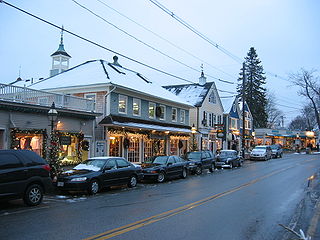
Kennebunkport is a census-designated place (CDP) consisting of the central village in the town of Kennebunkport in York County, Maine, United States. The population was 1,238 at the 2010 census, out of a total town population of 3,474. It is part of the Portland–South Portland–Biddeford, Maine Metropolitan Statistical Area.

<span class="mw-page-title-main">Constantia (CDP), New York</span> CDP in New York, United States

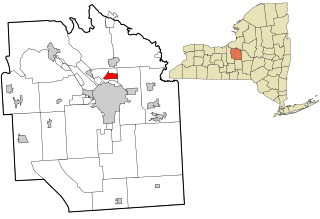
Constantia is a census-designated place (CDP) in the town of Constantia in Oswego County, New York, United States. Located on Oneida Lake, the community lies along State Route 49 and Scriba Creek. The population was 1,182 at the 2010 census.

<span class="mw-page-title-main">Minetto (CDP), New York</span> CDP in New York, United States

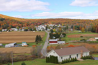
Minetto is a hamlet in Oswego County, New York, United States. The population was 1,069 at the 2010 census.

References

  1. "ArcGIS REST Services Directory". United States Census Bureau. Retrieved September 20, 2022.
  2. "US Gazetteer files: 2010, 2000, and 1990". United States Census Bureau. 2011-02-12. Retrieved 2011-04-23.
  3. "Census of Population and Housing". Census.gov. Retrieved June 4, 2016.
  4. "U.S. Census website". United States Census Bureau . Retrieved 2008-01-31.